Guinea, officially the Republic of Guinea, is a coastal country in West Africa. It borders the Atlantic Ocean to the west, Guinea-Bissau to the northwest, Senegal to the north, Mali to the northeast, Côte d'Ivoire to the southeast, and Sierra Leone and Liberia to the south. It is sometimes referred to as Guinea-Conakry, after its capital Conakry, to distinguish it from other territories in the eponymous region, such as Guinea-Bissau and Equatorial Guinea. Guinea has a population of 14 million and an area of 245,857 square kilometres (94,926 sq mi).

Ahmed Sékou Touré was a Guinean political leader and African statesman who was the first president of Guinea from 1958 until his death in 1984. Touré was among the primary Guinean nationalists involved in gaining independence of the country from France. He would later die in the United States in 1984.

Samory Toure, also known as Samori Toure, Samory Touré, or Almamy Samore Lafiya Toure, was a Mandinka Muslim cleric, military strategist, and founder of the Wassoulou Empire, an Islamic empire that was stretched across present-day north and eastern Guinea, north-eastern Sierra Leone, southern Mali, northern Côte d'Ivoire and part of southern Burkina Faso.

Kankan is the largest city in Guinea in land area, and the third largest in population, with a population of 198,013 people as of 2020. The city is located in eastern Guinea about 555 kilometres east of the national capital Conakry.

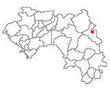
Siguiri is a city in northeastern Guinea on the River Niger. It is a sub-prefecture and capital of Siguiri Prefecture in the Kankan Region.

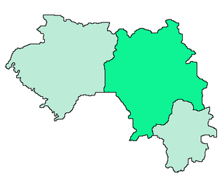
Kankan Region is a region of Guinea located in the east of the country. It is the largest region of Guinea by area. The region has five (5) prefectures.
The Wassoulou Empire, also referred to as the Ouassalou Empire, Mandinka Empire, Samory's Empire or the Samorian State, was a short-lived West African state that existed from roughly 1878 until 1898, although dates vary from source to source. It spanned from what is now southwestern Mali and upper Guinea, with its capital in Bissandugu; it expanded further south into Northern Sierra Leone and east into northern Ivory Coast before its downfall.

The Kénédougou Kingdom,, was a pre-colonial West African state established in the southeastern portion of present-day Mali, as well as parts of northern Côte d'Ivoire and western Burkina Faso.
Mandiana is a prefecture located in the Kankan Region of Guinea. The capital is Mandiana. The prefecture covers an area of 12,825 km.² and has a population of 335,999.

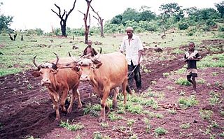
Kouroussa or Kurussa is a town located in northeastern Guinea, and is the capital of Kouroussa Prefecture. As of 2014 it had a population of 39,611 people. A trade center and river port from at least the time of the Mali Empire, Kouroussa has long relied upon its position near the upstream limit of navigation of the Niger River to make it an important crossroads for people and goods moving between the Guinea coast and the states of the western Soudan and Niger River valley. The town and surrounding area is a center of Malinke culture, and is known for its Djembe drumming tradition.
The Mandingo Wars were a series of conflicts from 1882 to 1898 between France and the Wassoulou Empire of the Mandingo people led by Samori Ture. Comparatively, the French faced serious resistance by the Mandinka, as they were able to make use of firearms and tactics that impeded French expansion in the area. The French were ultimately triumphant and established dominance over Mali, Guinea and the Ivory Coast.
The Diocese of Kankan is a Latin Church ecclesiastical territory or diocese of the Catholic Church in Guinea. It is a suffragan diocese in the ecclesiastical province of the metropolitan Archdiocese of Conakry, yet depends on the missionary Roman Congregation for the Evangelization of Peoples.
Tintioule is a town in the Kankan Region of Guinea. In 1875 it was the site of a meeting between Karamo Mori Kaba, ruler of the Bate Empire, and Samory Toure to formalize an alliance against the animist Conde clan.
Boula is a town and sub-prefecture in the Kankan Prefecture in the Kankan Region of eastern Guinea, near the borders of Mali and Ivory Coast. As of 2014 it had a population of 15,763 people.
Sabadou-Baranama is a town and sub-prefecture in the Kankan Prefecture in the Kankan Region of eastern Guinea. As of 2014 it had a population of 23,159 people.
Dialakoro is a town and sub-prefecture in the Mandiana Prefecture in the Kankan Region of eastern Guinea. As of 2014 it had a population of 63,159 people.
Koundianakoro is a town and sub-prefecture in the Mandiana Prefecture in the Kankan Region of eastern Guinea. As of 2014 it had a population of 31,489 people.
The Batè Empire was a pre-colonial state centred on Kankan in what is today Guinea. Founded by Mandinka and Soninke people as an Islamic merchant state in the 16th century, it survived until the late 19th century when it was conquered first by Samori Ture and then incorporated into French Guinea.

Abdoulaye Touré was a politician in the first Guinean republic. He was arrested after a coup in April 1984, and was executed in July 1985.

Ourembaya is a village of Mandinka people of Guinea, located at 12 kilometers south of Kankan.