Kita, Mali

Last updated
Kita
Commune and town
Kita Gare.jpg
Mali adm location map.svg
Red pog.svg
Kita
Location in Mali
Coordinates: 13°2′20″N9°29′15″W / 13.03889°N 9.48750°W / 13.03889; -9.48750
Country Flag of Mali.svg Mali
Region Kayes Region
Cercle Kita Cercle
Elevation
330 m (1,080 ft)
Population
 (2018 census) [1]
  Total463,787

Kita is a town and urban commune in western Mali. The town is the capital of the Kita Cercle in the Kayes Region. It lies on the eastern slope of Mount Kita (Bambara: "Kita-kulu"), known for its caves and rock paintings. Today, the town is known for its music, its annual Roman Catholic pilgrimage and its role as a processing center for the surrounding cotton- and peanut-growing region. Kita lies on the Dakar-Niger Railway and is the largest transit hub between Bamako (112 miles) and Kayes (205 miles). In the 2018 census the urban commune had a population of 463,787. [1]

Contents

In November 1955, Kita became a commune of average exercise. On March 2, 1966, Kita became a commune of full exercise. The town grew in the 1990s around the cotton industry, but this has since declined.

A fictionalized version of Kita features as the setting for Malian author Massa Makan Diabaté's "Kouta Trilogy" (Le lieutenant de Kouta, Le coiffeur de Kouta, and Le boucher de Kouta). [2]

History

Name

Kita proper has been called with different names throughout history. One of its earliest names was "Guénou Kourou". [3]

However, a second name "Sediousaba" [4] had been used for the small village, or rather an area in the town.

Birth & Settlements

Two major settlements have been considered the birth of the town of Kita, however the order of these settlements are still subjects to debate. One of the settlements was attributed to the Tounkara traders from Ouagadou, the Ghana empire. Their chief, Diouna Tounkara, created "Sediousaba", [4] which means "Three shea trees" as mentioned above. The second settlement was attributed to a Guinea trader, Siema Toloba Kamara, who created a village called "Fatali. Later, Siema Toloba Kamara and Diouna Tounkara allied with each other to form a new village called "Linguékoto". [4]

Population

In the Health Minister's 2018 census, Kita had a population of 463,787, [5] while in 2020, the urban area of Kita counted 65,908.[ citation needed ]

Climate

Kita has a fairly dry tropical savanna climate (Köppen Aw) with a hot to sweltering and arid dry season from November to late May and a hot, steamy wet season from late May to October. There is negligible rain and very low humidity in the dry season, whilst in the wet season rainfall totals around 900 millimetres or 35 inches with oppressive and uncomfortable humidity.

Climate data for Kita climate station (334 metres or 1,096 feet elevation) 1991-2020 averages
MonthJanFebMarAprMayJunJulAugSepOctNovDecYear
Average high °C (°F)33.6
(92.5)
36.0
(96.8)
39.1
(102.4)
40.6
(105.1)
39.3
(102.7)
35.8
(96.4)
32.1
(89.8)
30.1
(86.2)
32.1
(89.8)
34.6
(94.3)
35.8
(96.4)
34.2
(93.6)
35.2
(95.4)
Average low °C (°F)19.5
(67.1)
22.1
(71.8)
25.4
(77.7)
28.0
(82.4)
27.5
(81.5)
25.3
(77.5)
23.5
(74.3)
22.9
(73.2)
22.9
(73.2)
22.8
(73.0)
20.2
(68.4)
19.1
(66.4)
23.1
(73.6)
Average rainfall mm (inches)0.6
(0.02)
6.2
(0.24)
7.6
(0.30)
9.8
(0.39)
39.6
(1.56)
121.9
(4.80)
200.5
(7.89)
254.5
(10.02)
195.2
(7.69)
60.1
(2.37)
2.1
(0.08)
0.4
(0.02)
930.0
(36.61)
Average rainy days (≥ 1.0 mm)0.160.050.291.174.439.2313.1915.5513.595.730.370.1564.24
Mean monthly sunshine hours 249.7250.6290.4269.5262.3243.4202.9191.0217.0268.2254.3254.42,931.7
Source: Meteo Climat [6]

Notable residents

See also

Related Research Articles

<span class="mw-page-title-main">Massa Makan Diabaté</span> Malian historian, author, and playwright

Massa Makan Diabaté was a Malian historian, author, and playwright.

Essakane is a rural commune and village of the Cercle of Goundam in the Tombouctou Region of Mali. The commune includes around 16 small settlements. The small village of Essakane is around 70 kilometers west of the town of Timbuktu. The commune includes Lake Faguibine and two depressions, Lake Kamango and Lake Gouber, which fill with water in years when the annual flood of the Niger River is particularly extensive.

<span class="mw-page-title-main">Siby, Mali</span> Commune and village in Koulikoro Region, Mali

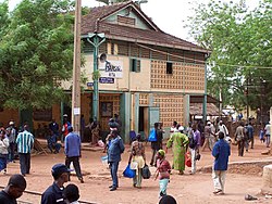
Siby is a village and rural commune in the Cercle of Kati in the Koulikoro Region of southern Mali. The commune contains 21 villages and in the 2009 census had a population of 26,632. The village lies 50 km southwest of the capital, Bamako, on the plain to the south of the Monts Mandingues. The RN5 road that links Bamako with Siguiri in Guinea runs through the village.

<span class="mw-page-title-main">Kita Cercle</span> Cercle in Kayes Region, Mali

Kita Cercle is an administrative subdivision of the Kayes Region of Mali. The administrative centre (chef-lieu) is the town of Kita. In the 2009 census the population of the cercle was 434,379.

<span class="mw-page-title-main">Banamba Cercle</span> Cercle in Koulikoro Region, Mali

Banamba Cercle is an administrative subdivision of the Koulikoro Region of Mali. Its seat is the town of Banamba, which is also its largest settlement. It lies at the center east of the region.

Andéramboukane is a town and cercle in Ménaka Region, Mali. It lies at the extreme east of the country, several kilometers north of the Nigerien border. It was previously a commune in Ménaka Cercle but was promoted to the status of a cercle when Ménaka Region was implemented in 2016.

Boudofo is a village and rural commune in the Cercle of Kita in the Kayes Region of south-western Mali. The commune includes 6 villages and in the 2009 census had a population of 4,885.

Makano or Makono is a small town and rural commune in the Cercle of Kita in the Kayes Region of southwestern Mali, near the border of Guinea. The commune includes 14 villages and in the 2009 census had a population of 9,826.

Namala or Namala Guimba is a small town and commune in the Cercle of Kita in the Kayes Region of south-western Mali. The commune contains 10 villages and in the 2009 census had a population of 15,667.

Gadougou I is a rural commune in the Cercle of Kita in the Kayes Region of south-western Mali. The commune includes 17 villages and in the 2009 census had a population of 25,775. The principal village is Sagabari.

Sirakoro is a village and rural commune in the Cercle of Kita in the Kayes Region of south-western Mali. The commune contains 10 villages and in the 2009 census had a population of 10,325.

Tambaga is a village and rural commune in the Cercle of Kita in the Kayes Region of south-western Mali. The commune contains 10 villages and in the 2009 census had a population of 11,152.

Séféto Nord is a rural commune in the Cercle of Kita in the Kayes Region of south-western Mali. The commune includes 6 villages and in the 2009 census had a population of 9,671. The principal village is Niagané.

Saboula is a rural commune in the Cercle of Kita in the Kayes Region of south-western Mali. The commune contains four villages and in the 2009 census had a population of 6,193. The principal town is Balandougou.

<span class="mw-page-title-main">M'Pessoba</span> Commune and town in Sikasso Region, Mali

M'Pessoba is a small town and commune in the Cercle of Koutiala in the Sikasso Region of southern Mali. The commune covers an area of 490 square kilometers and includes 19 settlements. In the 2009 census it had a population of 36,297. The town of M'Pessoba, the administrative centre (chef-lieu) of the commune, is 40 km northwest of Koutiala.

Ténenkou is a village and commune and seat of the Ténenkou Cercle in the Mopti Region of Mali. In 2009 the commune had a population of 11,310.

Diondiori is a small town and commune of the Cercle of Ténenkou in the Mopti Region of Mali. The commune includes 27 villages and in 2009 had a population of 20,160.

<span class="mw-page-title-main">Léré, Mali</span> Commune and town in Tombouctou Region, Mali

Léré is a small town and rural commune of the Cercle of Niafunké in the Tombouctou Region of Mali. The commune covers an area of approximately 1,342 square kilometers and contains the town and 18 villages. In the 2009 census the commune had a population of 16,072.

Kolonigué is a rural commune in the Cercle of Koutiala in the Sikasso Region of southern Mali. The commune covers an area of 456 square kilometers and includes 10 settlements. In the 2009 census it had a population of 32,447. The small town of Molobala, the administrative centre (chef-lieu) of the commune, is 38 km southeast of Koutiala.

<i>Le lieutenant de Kouta</i>

Le lieutenant de Kouta is a 1979 novel by Malian author Massa Makan Diabaté. Loosely based on the author's hometown of Kita, Mali, the novel tells the story of a recently returned lieutenant from the French Colonial Army, Siriman Keita, and his struggle to adjust to his village's changing customs. It is the first book in Diabaté's "Kouta trilogy," followed by Le coiffeur de Kouta and Le boucher de Kouta, which feature many of the same characters.

References

  1. 1 2 ANNUAIRE STATISTIQUE 2018 DU SYSTEME LOCAL D'INFORMATION SANITAIRE DU MALI (PDF) (in French), République de Mali: Ministere de la Sante et du Développement Social".
  2. Drame, Kandioura. "Diabaté, Massa Makan." The Encyclopedia of African Literatures. Ed. Simon Gikandi. p. 195.
  3. KEITA, MADIBA (22 July 2019). "Le saviez-vous ?: LES MILLE ET UN MYSTÈRES DE KITA". ESSOR.
  4. 1 2 3 TELLIER, G (1902). Autour de Kita - Etude Soudanaise (in French). Imprimerie et Librairie Henri Charles-Lavauzelle. p. 33.
  5. Ministère de la Santé et de l’Hygiène Publique. "Annuaire Statistique 2018 du Système Local d'Information Sanitaire ANNUAIRE STATISTIQUE 2018 DU SYSTEME LOCAL D'INFORMATION SANITAIRE DU MALI" (PDF). sante.gov.ml. Retrieved August 12, 2022.
  6. "Climate Normals 1991-2020". Meteo Climat. Retrieved 11 April 2021.