
The Mali Empire was an empire in West Africa from c. 1226 to 1670. The empire was founded by Sundiata Keita and became renowned for the wealth of its rulers, especially Mansa Musa. At its peak, Mali was the largest empire in West Africa, widely influencing the culture of the region through the spread of its language, laws, and customs.
Sundiata Keita was a prince and founder of the Mali Empire. He was also the great-uncle of the Malian ruler Mansa Musa, who is usually regarded as the wealthiest person of all time, although there are no reliable ways to accurately calculate his wealth.
In 1324, while staying in Cairo during his hajj, Mansa Musa, the ruler of the Mali Empire, told an Egyptian official whom he had befriended that he had come to rule when his predecessor led a large fleet in an attempt to cross the Atlantic Ocean and never returned. This account, recorded by the Arab historian al-Umari, has attracted considerable interest and speculation as a possible instance of pre-Columbian trans-oceanic contact. The voyage is popularly attributed to a Mansa Abu Bakr II, but no such mansa ever reigned. Rather, the voyage is inferred to have been undertaken by Mansa Muhammad ibn Qu.

Ségou is a town and an urban commune in south-central Mali that lies 235 kilometres (146 mi) northeast of Bamako on the right bank of the River Niger. The town is the capital of the Ségou Cercle and the Ségou Region. With 130,690 inhabitants in 2009, it is the fifth-largest town in Mali.

The Bamana Empire was one of the largest states of West Africa in the 18th century. Along with Kaarta it was one of the most important successors of the Songhai Empire. Based on an earlier kingdom established in 1640, it grew into a powerful empire in the early 18th century under Bitòn Coulibaly. The empire existed as a centralized state from 1712 until the 1861 invasion by the Toucouleur conqueror El Hadj Umar Tall.
Mansa Uli, also known as Yérélinkon, was the second mansa of the Mali Empire. He was the son and successor of Sunjata.
Abu Bakr, known as Bata Mande Bori in oral tradition, was the fifth mansa of the Mali Empire, reigning during the late 13th century. He was a son of a daughter of Sunjata, the founder of the Mali Empire, and may have been adopted by Sunjata as a son. Abu Bakr succeeded Khalifa, a tyrant who was deposed after a brief reign. Abu Bakr was the first mansa of the Mali Empire to succeed through the female line. It remains debated whether Abu Bakr's succession marked a return to a traditional pattern of succession that had been ignored by his predecessors or if it was a break from traditional succession caused by political instability. After an unremarkable reign, Abu Bakr was succeeded by Sakura, an enslaved court official who seized power in a coup.
Sakura was a mansa of the Mali Empire who reigned during the late 13th century, known primarily from an account given by Ibn Khaldun in his Kitāb al-ʻIbar. Sakura was not a member of the ruling Keita dynasty, and may have been formerly enslaved. He usurped the throne following a period of political instability and led Mali to considerable territorial expansion. During his reign, trade between the Mali Empire and the rest of the Muslim world increased. He was killed in the early 1300s while returning from the hajj and the Keita dynasty was restored to power.
Sunjata is an epic poem of the Malinke people that tells the story of the hero Sundiata Keita, the founder of the Mali Empire. The epic is an instance of oral tradition, going back to the 13th century and narrated by generations of jelis (griots). There is no single or authoritative version. Material pertaining to the epic first began to be collected during the early 20th century in French Sudan, notably by the French elite school École William Ponty, resulting in the "modern" version of the tale as considered standard today, based on the oral account by Djeli Mamoudou Kouyate, a jeli or traditional oral historian, translated into French by Djibril Tamsir Niane in 1960.
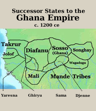
The Sosso Empire, also written as Soso or Susu, or alternatively Kaniaga, was kingdom of West Africa that originated as a vassal of the Ghana Empire before breaking away and conquering their former overlords. Inhabited by the Soninke ancestors of the modern-day Sosso people, it was centered in the region south of Wagadou and north of Beledougou. The empire peaked under the reign of Soumaoro Kante, who was defeated by the rising Mali Empire of Sundiata Keita.

Mansa Sulayman was mansa of the Mali Empire during the middle of the 14th century. He was the brother of Mansa Musa and succeeded Musa's son Magha as mansa.
Mansa Jata, commonly referred to as Mari Jata II, possibly incorrectly, known in oral histories as Konkodugu Kamissa was mansa of Mali from 1360 to 1374. He was an ineffective ruler, and his reign, recorded by the contemporary North African historian Ibn Khaldun, marked the beginning of the decline of the Mali Empire.

Cheick Modibo Diarra is a Malian astrophysicist, businessman, and politician who was acting Prime Minister of Mali from April 2012 to December 2012.

Siby is a village and rural commune in the Cercle of Kati in the Koulikoro Region of southern Mali. The commune contains 21 villages and in the 2009 census had a population of 26,632. The village lies 50 km southwest of the capital, Bamako, on the plain to the south of the Monts Mandingues. The RN5 road that links Bamako with Siguiri in Guinea runs through the village.
Mande Bori, also known as Mande Bakari and known in Arabic as Abu Bakr, is a heroic figure in Mande oral tradition who was involved in the founding of the Mali Empire. He was the brother and right-hand man of Sunjata, the founder of the empire, and served as the empire's kankoro-sigui, an office that has been translated as "viceroy" or "lieutenant-general". Though Mande Bori never himself reigned as mansa, his grandsons Musa and Suleyman ruled the Mali Empire at the apex of its power and prestige, and he is often erroneously cited as Mansa Abu Bakr II.

Nioro Cercle is an administrative subdivision of the Kayes Region of Mali. Its administrative center (chef-lieu) is the town of Nioro du Sahel. The commune is on the Mauritanian border and has long been a major stop on the trans-Saharan trade.
Nyamina is a small town and rural commune in the Cercle of Koulikoro in the Koulikoro Region of south-western Mali. The commune lies to the north of the Niger River and covers an area of 1,283 km2. It includes the town of Nyamina and 47 villages. In the 2009 census the commune had a population of 35,548. The town lies on the left bank of the river, 80 km northeast of Koulikoro.
Dankaran Touman was the first son of Naré Maghann Konaté in the Malian epic of Sundiata. He was also the King of Manden before the establishment of the Mali Empire.
Koli Tenguella was a Fulani warrior and leader who was pivotal in establishing the Empire of Great Fulo.
Diarra, also referred to as Kingui, Diafunu, or Kaniaga, was a Soninke state in what is now northwestern Mali, centered around the town of Diarra. Founded in the 11th century, it was occasionally independent but frequently under the domination of a series of Sahelian empires until its final destruction by the Toucouleur Empire in the 19th century.
