Kouniakary | |
|---|---|
Urban commune and town | |
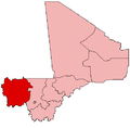
 Kouniakary Location in Mali | |
| Coordinates: 14°34′35″N10°54′0″W / 14.57639°N 10.90000°W | |
| Country | |
| Region | Kayes Region |
| Cercle | Kayes Cercle |
| Population (2009 census) [1] | |
• Total | 8,135 |
| Time zone | UTC+0 (GMT) |
Kouniakary or Koniakari is a town and urban commune in the Cercle of Kayes in the Kayes Region of south-western Mali. The town is located approximately 65 kilometres from Kayes city. In 2009 the commune had a population of 8135.
Koniakary was the capital of the kingdom of Khasso, and was sacked by Kaarta in 1800. [2] In 1855, El Hadj Umar Tall constructed a tata at Koniakari to protect against the soldiers of French Colonel Louis Archinard; the tata still stands today, and has become a tourist attraction. [3]