Kinnikinnick Creek

Last updated

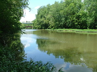
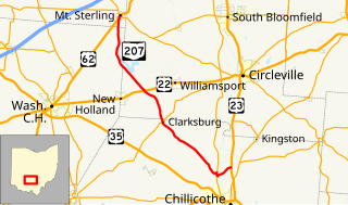
Kinnikinnick Creek is a shallow waterway that is part of the Scioto River watershed, flowing through southern Pickaway and northern Ross Counties in Ohio. The area through which the creek flows, which includes the villages of Wisler, Kingston and Kinnikinnick, Ohio is known locally as the Kinnikinnick Prairie.

Scioto River river in the United States of America

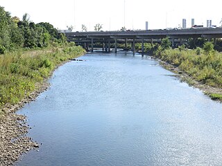
The Scioto River is a river in central and southern Ohio more than 231 miles (372 km) in length. It rises in Auglaize County in west central Ohio, flows through Columbus, Ohio, where it collects its largest tributary, the Olentangy River, and meets the Ohio River at Portsmouth. Early settlers and Native Americans used the river for shipping but it is now too small for modern commercial shipping. The primary economic importance for the river now is for recreation and drinking water. It is the longest river that is entirely within Ohio.

Ohio State of the United States of America

Ohio is a Midwestern state in the Great Lakes region of the United States. Of the fifty states, it is the 34th largest by area, the seventh most populous, and the tenth most densely populated. The state's capital and largest city is Columbus.

Kingston, Ohio Village in Ohio, United States

Kingston is a village in Ross County, Ohio, United States. The population was 1,032 at the 2010 census.

Contents

The Kinnikinnick has two branches, the main (north) branch, and the south branch. The creek’s northern headwaters form near the Pickaway County village of Leistville, Ohio, and flow south to the confluence of the creek’s southern branch, which has its head waters in Ross County. There, the creek begins its west-southwest path until it merges with the Scioto River north of the city of Chillicothe, Ohio.

Pickaway County, Ohio County in the United States

Pickaway County is a county located in the U.S. state of Ohio. As of the 2010 census, the population was 55,698. Its county seat is Circleville. Its name derives from the Pekowi band of Shawnee Indians, who inhabited the area.

Ross County, Ohio County in the United States

Ross County is a county located in the Appalachian region of the U.S. state of Ohio. As of the 2010 census, the population was 78,064. Its county seat is Chillicothe, the first and third capital of Ohio. Established on August 20, 1798, the county is named for Federalist Senator James Ross of Pennsylvania.

Chillicothe, Ohio City in Ohio, United States

Chillicothe is a city in and the county seat of Ross County, Ohio, United States. Located along the Scioto River 45 miles south of Columbus, Chillicothe was the first and third capital of Ohio.

The creek was named for the Native American tobacco product kinnikinnick. [1] The creek was a resource for Native Americans in the days before European Settlement. When white settlers moved into the region around 1800, Kinnikinnick was a significant source of fresh water for consumption, and crop irrigation.

Kinnikinnick is a Native American and First Nations herbal smoking mixture, made from a traditional combination of leaves or barks. Recipes for the mixture vary, as do the uses, from social, to spiritual to medicinal.

Water chemical compound

Water is a transparent, tasteless, odorless, and nearly colorless chemical substance, which is the main constituent of Earth's streams, lakes, and oceans, and the fluids of most living organisms. It is vital for all known forms of life, even though it provides no calories or organic nutrients. Its chemical formula is H2O, meaning that each of its molecules contains one oxygen and two hydrogen atoms, connected by covalent bonds. Water is the name of the liquid state of H2O at standard ambient temperature and pressure. It forms precipitation in the form of rain and aerosols in the form of fog. Clouds are formed from suspended droplets of water and ice, its solid state. When finely divided, crystalline ice may precipitate in the form of snow. The gaseous state of water is steam or water vapor. Water moves continually through the water cycle of evaporation, transpiration (evapotranspiration), condensation, precipitation, and runoff, usually reaching the sea.

Irrigation artificial application of water to the land

Irrigation is the application of controlled amounts of water to plants at needed intervals. Irrigation helps to grow agricultural crops, maintain landscapes, and revegetate disturbed soils in dry areas and during periods of less than average rainfall. Irrigation also has other uses in crop production, including frost protection, suppressing weed growth in grain fields and preventing soil consolidation. In contrast, agriculture that relies only on direct rainfall is referred to as rain-fed or dry land farming.

The Kinnikinnick is considered a major waterway feeder for the Scioto River by The Ohio State University Extension Services. Portions are navigable by canoe.

Location

See also

Related Research Articles

Franklin County, Ohio County in the United States

Franklin County is a county in the U.S. state of Ohio. As of 2017 census estimates, the population was 1,291,981, making it the most populous county in Ohio. Its county seat is Columbus, the state capital and most populous city in Ohio. The county was established on April 30, 1803, less than two months after Ohio became a state, and was named after Benjamin Franklin. Franklin County originally extended all the way north to Lake Erie before Ohio subdivided further into more counties.

Teays River

The Teays River was a major preglacial river that drained much of the present Ohio River watershed, but took a more northerly downstream course. Traces of the Teays across northern Ohio and Indiana are represented by a network of river valleys. The largest still existing contributor to the former Teays River is the Kanawha River in West Virginia, which is itself an extension of the New River. The name Teays from the Teays Valley is associated with this buried valley since 1910. The more appropriate name would be ancestral Kanawha Valley. The term Teays is used when discussing the buried portion of the ancestral Kanawha River. The Teays was comparable in size to the Ohio River. The River's headwaters were near Blowing Rock, North Carolina; it then flowed through Virginia, West Virginia, Ohio, Indiana and Illinois.. The largest tributary to the Teays River was the Old Kentucky River, which extended from southern Kentucky through Frankfort and subsequently flowed northeast, meeting other tributaries and eventually joining the Teays.

Olentangy River River in Ohio, United States of America

The Olentangy River is a 97-mile-long (156 km) tributary of the Scioto River in Ohio.

Pickaway Plains is a wide area of rolling hills beginning about 3 miles south of Circleville, Ohio, and extending several miles to the north and south. This geological area was formed by sand and gravel deposited by melting water from the last glacier to retreat from the region during the Ice Age. During the time of inhabitation by the Shawnee, the Pickaway Plains were covered by prairie vegetation, mainly grasses.

Ohio State Route 104 highway in Ohio

State Route 104 is a north–south highway in Southern Ohio. Its southern terminus is at U.S. Route 23 in Portsmouth, Ohio and its northern terminus is at U.S. Route 33 in Columbus. The route passes through or close to the towns of Portsmouth, Waverly, Chillicothe, Grove City, and Columbus. From Waverly to Chillicothe, it overlaps U.S. Route 23.

Paint Creek (Scioto River tributary) river in the United States of America

Paint Creek is a tributary of the Scioto River, 94.7 mi (152.5 km) long, in south-central Ohio in the United States. Via the Scioto and Ohio Rivers, it is part of the watershed of the Mississippi River. It drains an area of 1,143 mi² (2960 km²).

Ohio State Route 207 highway in Ohio

State Route 207 is a 31.23-mile (50.26 km) long north–south state highway in the southern portion of the U.S. state of Ohio. The southern terminus of SR 207 is at a diamond interchange with U.S. Route 23 (US 23) nearly 4 miles (6.4 km) north of Chillicothe. Its northern terminus is in Mount Sterling, following a 0.33-mile (0.53 km) long concurrenty with US 62 and SR 3, at the intersection where they meet SR 56.

Big Walnut Creek river in the United States of America

Big Walnut Creek starts near Mount Gilead, Ohio in Morrow County. It flows south to eastern Delaware County and parallels Alum Creek. It passes to the east of Sunbury and into Hoover Reservoir. The reservoir crosses into Franklin County and flows through Gahanna and Whitehall. Near Obetz it is joined by its principal tributaries Alum Creek and Blacklick Creek at the Three Creeks Columbus Metro Park. It flows through southern Franklin County and joins the Scioto River near the Franklin-Pickaway Counties line at 39°47′57″N83°00′34″W.

Ohio State Route 762 highway in Ohio

State Route 762 is an east–west state highway in central Ohio, a U.S. state. The highway has its western terminus at a signalized intersection with the concurrency of U.S. Route 62 and SR 3 just 0.25 miles (0.40 km) south of the village limits of Harrisburg. SR 762's eastern terminus is at an intersection of Pickaway County Route 385 near the Rickenbacker International Airport.

Lake Erie Basin

Lake Erie Basin consists of Lake Erie and surrounding watersheds, which are typically named after the river, creek, or stream that provides drainage into the lake. The watersheds are located in the states of Indiana, Michigan, New York, Ohio, and Pennsylvania in the United States, and in the Province of Ontario in Canada. The basin is part of the Great Lakes Basin and Saint Lawrence River Watershed, which feeds into the Atlantic Ocean. 80% of the lake's water flows in from the Detroit River, with only 9% coming from all of the remaining watersheds combined. A littoral zone serves as the interface between land and lake, being that portion of the basin where the lake is less than 15 feet (4.6 m) in depth.

Roxabell, Ohio human settlement in Ohio, United States of America

Roxabel is an unincorporated community in central Concord Township, Ross County, Ohio, United States. It lies at the intersection of Davis Hill and Jamison Roads, little more than 1 mile south of the village of Frankfort. Two parts of the North Fork of Paint Creek, a subsidiary of the Ohio River through the Scioto River, pass near Roxabel. It is located slightly more than 3 miles north of State Route 28, midway between the cities of Chillicothe — the county seat of Ross County — and Greenfield.

Simon Kenton Council

The Simon Kenton Council (#441) is a Boy Scouts of America council created in 1994 that serves members of the Cub Scouts, Scouts BSA, Venturing, Exploring and in-school programs in central and southern Ohio, and northern Kentucky. The council is divided into ten districts with headquarters in Columbus, Ohio and additional service centers located in Chillicothe and Portsmouth, Ohio. Simon Kenton Council is part of Area 4 of the Central Region, and is named in honor of frontiersman Simon Kenton.

Big Darby Creek river in the United States of America

The Big Darby Creek State Scenic River is a river located in northwestern central Ohio, and an important tributary to the Lower Scioto River. The river's major tributary is the Little Darby Creek.

Pickaway-Ross Career & Technology Center is a vocational-technical school serving Pickaway and Ross counties in Ohio. The school is located at 895 Crouse Chapel Road north of Chillicothe, Ohio and is governed by the Pickaway-Ross County Joint Vocational School District.

Kinnikinnick, Ohio Unincorporated community in Ohio, United States

Kinnikinnick is an unincorporated community in Ross County, Ohio, United States. Kinnikinnick is located at the junction of Ohio State Route 159 and Ohio State Route 180, 16.6 miles (26.7 km) north-northeast of Chillicothe.

Pee Pee Creek is a stream in Pike County, Ohio, in the United States.

References

  1. Overman, William Daniel (1958). Ohio Town Names. Akron, OH: Atlantic Press. p. 70.
  2. 1 2 U.S. Geological Survey Geographic Names Information System: Kinnikinnick Creek