
Canada has a vast geography that occupies much of the continent of North America, sharing a land border with the contiguous United States to the south and the U.S. state of Alaska to the northwest. Canada stretches from the Atlantic Ocean in the east to the Pacific Ocean in the west; to the north lies the Arctic Ocean. Greenland is to the northeast with a shared border on Hans Island. To the southeast Canada shares a maritime boundary with France's overseas collectivity of Saint Pierre and Miquelon, the last vestige of New France. By total area, Canada is the second-largest country in the world, after Russia. By land area alone, however, Canada ranks fourth, the difference being due to it having the world's largest proportion of fresh water lakes. Of Canada's thirteen provinces and territories, only two are landlocked while the other eleven all directly border one of three oceans.

The Nelson River is a river of north-central North America, in the Canadian province of Manitoba. The river drains Lake Winnipeg and runs 644 kilometres (400 mi) before it ends in Hudson Bay. Its full length is 2,575 kilometres (1,600 mi), it has mean discharge of 2,370 cubic metres per second (84,000 cu ft/s), and has a drainage basin of 1,072,300 square kilometres (414,000 sq mi), of which 180,000 square kilometres (69,000 sq mi) is in the United States.

The Manitoba Hydro-Electric Board, operating as Manitoba Hydro, is the electric power and natural gas utility in the province of Manitoba, Canada. Founded in 1961, it is a provincial Crown Corporation, governed by the Manitoba Hydro-Electric Board and the Manitoba Hydro Act. Today the company operates 16 interconnected generating stations. It has more than 527,000 electric power customers and more than 263,000 natural gas customers. Since most of the electrical energy is provided by hydroelectric power, the utility has low electricity rates. Stations in Northern Manitoba are connected by a HVDC system, the Nelson River Bipole, to customers in the south. The internal staff are members of the Canadian Union of Public Employees Local 998 while the outside workers are members of the International Brotherhood of Electrical Workers Local 2034.

Morden is a city located in the Pembina Valley region of southern Manitoba, Canada near the United States border. It is about 11 km (6.8 mi) west of the neighbouring city of Winkler; together Morden and Winkler are often referred to as Manitoba's Twin Cities. Morden, which is surrounded by the Rural Municipality of Stanley, is the eighth largest and fastest-growing city in Manitoba. According to Statistics Canada, the city had a population of 9,929 in 2021, an increase of 14.5% from 2016, making it Manitoba's fastest growing city.
Riding Mountain National Park is a national park in Manitoba, Canada. The park is located within Treaty 2 Territory and sits atop the Manitoba Escarpment. Consisting of a protected area 2,969 km2 (1,146 sq mi), the forested parkland stands in sharp contrast to the surrounding prairie farmland. It was designated a national park because it protects three different ecosystems that converge in the area; grasslands, upland boreal and eastern deciduous forests. It is most easily reached by Highway 10 which passes through the park. The south entrance is at the townsite of Wasagaming, which is the only commercial centre within the park boundaries.
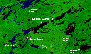
Cross Lake is a community in the Northern Region of the Canadian province of Manitoba, situated on the shores of the Nelson River where the river enters the namesake Cross Lake. An all-weather road, PR 374, connects the communities to PR 373 via the Kichi Sipi Bridge.

St. Clements is a rural municipality (RM) in Manitoba, Canada. It is located to the north-east of Winnipeg, stretching from East St. Paul and Birds Hill Provincial Park in the south to Lake Winnipeg and Grand Beach Provincial Park to the north. The Red River demarcates the western boundary of the municipality. St. Clements contains the communities of East Selkirk, and Lockport east of the Red River. It almost completely surrounds the Brokenhead 4 Indian reserve, with the exception of a small lakefront on Lake Winnipeg.

Whiteshell Provincial Park is a provincial park in southeast Manitoba, approximately 120 kilometres (75 mi) east of the city of Winnipeg. The park is considered to be a Class II protected area under the IUCN protected area management categories. It is 275,210 hectares in size.
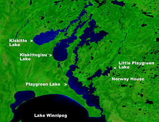
Playgreen Lake or Play Green Lake, is a lake in the province of Manitoba in Canada. The lake covers an area of 657 square kilometres (254 sq mi) and it is a part of the Nelson River watershed. The lake is the ninth largest lake in the province. It is located along the Nelson River some 10 kilometres (6.2 mi) north from the north end of Lake Winnipeg. It was first mapped by noted British surveyor, map-maker, chief fur trader and the explorer Peter Fidler in 1809.

The Antler River is located in the Prairie Pothole Region of North America's Great Plains in south-eastern Saskatchewan and south-western Manitoba in Canada in an area known as Palliser's Triangle. Its source is in Saskatchewan's Moose Mountain Upland and it is a major tributary of the Souris River. As a result, its flood levels are monitored by the United States Geological Survey.
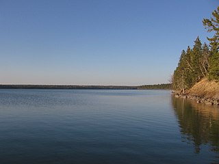
Cross Lake is a large lake in Manitoba on the Nelson River north of Lake Winnipeg. It is long and narrow and extends 102 kilometres (63 mi) east-northeast.
The Rural Municipality of Glenella is a former rural municipality (RM) in the Canadian province of Manitoba. It was originally incorporated as a rural municipality on April 10, 1920. It ceased on January 1, 2015, as a result of its provincially mandated amalgamation with the RM of Lansdowne to form the Municipality of Glenella – Lansdowne.

Provincial Road 373 is a highly recognized all-weather provincial road in Division 22 of Manitoba. The road was made famous by a group of singers from Norway House, who named their band Highway 373. PR 373 begins at an intersection with Highway 6 in Setting Lake, heads eastward through rural regions, and terminating at an intersection with local roads in Norway House. There is one major intersection along the way, Road 374, which heads north to Cross Lake. PR 373's entire length is declared a class A1 provincial road.

Split Lake is a lake on the Nelson River in Manitoba, Canada. The settlement of Split Lake is located on a peninsula on the northern shore. The lake is about 46 km long.
Kiskittogisu Lake is a lake in the province of Manitoba in Canada north of Lake Winnipeg. The lake is a part of the Nelson River watershed and is located west of Playgreen Lake and southeast of Kiskitto Lake on the west channel of the Nelson River. The west channel flows through the north ends of Playgreen Lake, Kiskittogisu Lake and Kiskitto Lake into Cross Lake at the Manitoba Hydro's Jenpeg Generating Station and Dam. The lake is about 46 km long.

Sipiwesk Lake is a large lake in the province of Manitoba in Canada north of Lake Winnipeg. The lake is a part of the Nelson River watershed and is located north of Cross Lake. The lake is about 78 km long.

Stephens Lake is a reservoir in the province of Manitoba in Canada north of Lake Winnipeg. The reservoir was created in 1971 by the Kettle Dam and received its official name of Stephens Lake in 1972. The lake is 32 kilometres (20 mi) long from the inflow of the Nelson River to the outflow at the Kettle Dam. The lake is located 45 kilometres (28 mi) northeast of Split Lake and 150 kilometres (93 mi) west of the Hudson Bay.
The D Division is the division of the Royal Canadian Mounted Police responsible for federal policing in Manitoba and, at times, northwestern Ontario. Headquartered in Winnipeg, the division is commanded by Assistant Commissioner Rob Hill and consists of 1089 police officers and 438 support staff.
Armit Meadows Ecological Reserve is an ecological reserve located in Porcupine Provincial Forest, Manitoba, Canada. It was established in 2015 under the Manitoba Ecological Reserves Act. It is 2.63 square kilometres (1.02 sq mi) in size.


