
Lake Winnipeg is a very large, relatively shallow 24,514-square-kilometre (9,465 sq mi) lake in North America, in the province of Manitoba, Canada. Its southern end is about 55 kilometres (34 mi) north of the city of Winnipeg. Lake Winnipeg is Canada's sixth-largest freshwater lake and the third-largest freshwater lake contained entirely within Canada, but it is relatively shallow excluding a narrow 36 m (118 ft) deep channel between the northern and southern basins. It is the eleventh-largest freshwater lake on Earth. The lake's east side has pristine boreal forests and rivers that were in 2018 inscribed as Pimachiowin Aki, a UNESCO World Heritage Site. The lake is 416 km (258 mi) from north to south, with remote sandy beaches, large limestone cliffs, and many bat caves in some areas. Manitoba Hydro uses the lake as one of the largest reservoirs in the world. There are many islands, most of them undeveloped.
Lake Manitoba is the 14th largest lake in Canada and the 33rd largest lake in the world with a total area of 4,624 square kilometres (1,785 sq mi). It is located within the Canadian province of Manitoba about 75 kilometres (47 mi) northwest of the province's capital, Winnipeg, at 50°59′N98°48′W.

The Nelson River is a river of north-central North America, in the Canadian province of Manitoba. The river drains Lake Winnipeg and runs 644 kilometres (400 mi) before it ends in Hudson Bay. Its full length is 2,575 kilometres (1,600 mi), it has mean discharge of 2,370 cubic metres per second (84,000 cu ft/s), and has a drainage basin of 1,072,300 square kilometres (414,000 sq mi), of which 180,000 square kilometres (69,000 sq mi) is in the United States.

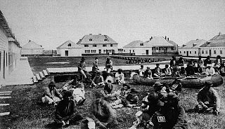
York Factory was a settlement and Hudson's Bay Company (HBC) factory located on the southwestern shore of Hudson Bay in northeastern Manitoba, Canada, at the mouth of the Hayes River, approximately 200 kilometres (120 mi) south-southeast of Churchill.

The Manitoba Hydro-Electric Board, operating as Manitoba Hydro, is the electric power and natural gas utility in the province of Manitoba, Canada. Founded in 1961, it is a provincial Crown Corporation, governed by the Manitoba Hydro-Electric Board and the Manitoba Hydro Act. Today the company operates 16 interconnected generating stations. It has more than 527,000 electric power customers and more than 263,000 natural gas customers. Since most of the electrical energy is provided by hydroelectric power, the utility has low electricity rates. Stations in Northern Manitoba are connected by a HVDC system, the Nelson River Bipole, to customers in the south. The internal staff are members of the Canadian Union of Public Employees Local 998 while the outside workers are members of the International Brotherhood of Electrical Workers Local 2034.

The Hayes River is a river in Northern Manitoba, Canada, that flows from Molson Lake to Hudson Bay at York Factory. It was historically an important river in the development of Canada and is now a Canadian Heritage River and the longest naturally flowing river in Manitoba.
Norway House is a population centre of over 5,000 people, some 30 km (19 mi) north of Lake Winnipeg, on the bank of the eastern channel of Nelson River, in the province of Manitoba, Canada. The population centre shares the name Norway House with the northern community of Norway House and Norway House 17, a First Nation reserve of the Norway House Cree Nation. Thus, Norway House has both a Chief and a Mayor.
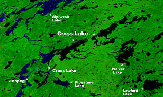
Cross Lake is a community in the Northern Region of the Canadian province of Manitoba, situated on the shores of the Nelson River where the river enters the namesake Cross Lake. An all-weather road, PR 374, connects the communities to PR 373 via the Kichi Sipi Bridge.

The Nelson River Hydroelectric Project refers to the construction of a series of dams and hydroelectric power plants on the Nelson River in Northern Manitoba, Canada. The project began to take shape in the late 1950s, with the planning and construction of the Kelsey dam and hydroelectric power station, and later was expanded to include the diversion of the upper Churchill River into the Nelson River and the transformation of Lake Winnipeg, the world's 11th largest freshwater lake, into a hydroelectric reservoir. The project is owned and operated by Manitoba Hydro, the electrical utility in the province.
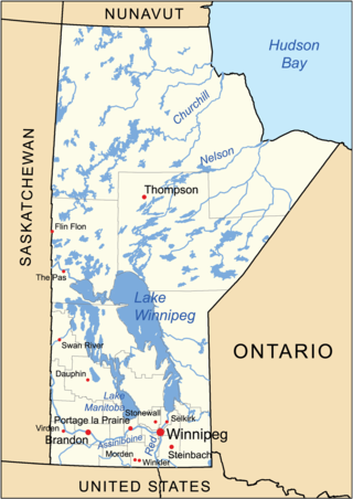
The geography of Manitoba addresses the easternmost of the three prairie Canadian provinces, located in the longitudinal centre of Canada. Manitoba borders on Saskatchewan to the west, Ontario to the east, Nunavut to the north, and the American states of North Dakota and Minnesota to the south. Although the border with Saskatchewan appears straight on large-scale maps, it actually has many right-angle corners that give the appearance of a slanted line. In elevation, Manitoba ranges from sea level on Hudson Bay to 2727 ft (831 m) on top of Baldy Mountain. The northern sixty percent of the province is on the Canadian Shield. The northernmost regions of Manitoba lie permafrost, and a section of tundra bordering Hudson Bay.
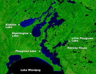
Playgreen Lake or Play Green Lake, is a lake in the province of Manitoba in Canada. The lake covers an area of 657 square kilometres (254 sq mi) and it is a part of the Nelson River watershed. The lake is the ninth largest lake in the province. It is located along the Nelson River some 10 kilometres (6.2 mi) north from the north end of Lake Winnipeg. It was first mapped by noted British surveyor, map-maker, chief fur trader and the explorer Peter Fidler in 1809.
Cross Lake is a large lake in Manitoba on the Nelson River north of Lake Winnipeg. It is long and narrow and extends 102 kilometres (63 mi) east-northeast.

Provincial Road 373 is a highly recognized all-weather provincial road in Division 22 of Manitoba. The road was made famous by a group of singers from Norway House, who named their band Highway 373. PR 373 begins at an intersection with Highway 6 in Setting Lake, heads eastward through rural regions, and terminating at an intersection with local roads in Norway House. There is one major intersection along the way, Road 374, which heads north to Cross Lake. PR 373's entire length is declared a class A1 provincial road.

Split Lake is a lake on the Nelson River in Manitoba, Canada. The settlement of Split Lake is located on a peninsula on the northern shore. The lake is about 46 km long.

Southern Indian Lake is a large lake in northern Manitoba, Canada. It has an area of 2,247 square kilometres (868 sq mi) with a surface elevation of 258 metres (846 ft).
Schist Lake is approximately 3 kilometres (1.9 mi) southeast of Flin Flon, Manitoba. The lake has a maximum depth of 30 metres (98 ft). It is composed of four main channels, the West Arm, Northwest Arm, Inlet Arm and Northeast Arm. It drains into Lake Athapapuskow via Schist Creek and is part of the Nelson River watershed. The Flin Flon/Channing Water Aerodrome is located on the north end of the Northwest Arm.
Kiskitto Lake is a lake in the province of Manitoba in Canada north of Lake Winnipeg. The lake is a part of the Nelson River watershed and is located northwest of Kiskittogisu Lake on the west channel of the Nelson River. The west channel flows through the north ends of Playgreen Lake, Kiskittogisu Lake and Kiskitto Lake into Cross Lake at the Manitoba Hydro's Jenpeg Generating Station and Dam. The lake is about 57 km long.

Sipiwesk Lake is a large lake in the province of Manitoba in Canada north of Lake Winnipeg. The lake is a part of the Nelson River watershed and is located north of Cross Lake. The lake is about 78 km long.

Stephens Lake is a reservoir in the province of Manitoba in Canada north of Lake Winnipeg. The reservoir was created in 1971 by the Kettle Dam and received its official name of Stephens Lake in 1972. The lake is 32 kilometres (20 mi) long from the inflow of the Nelson River to the outflow at the Kettle Dam. The lake is located 45 kilometres (28 mi) northeast of Split Lake and 150 kilometres (93 mi) west of the Hudson Bay.


