Kristiine

Last updated
Kristiine
District of Tallinn
Ohuvaade Kristiine linnaosa pohjaosale.png
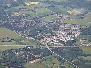
Aerial view of northern part of Kristiine, mostly Lilleküla.
Kristiine linnaosa lipp.svg
Kristiine linnaosa vapp.svg
Kristiine location Tallinn.svg
Location of Kristiine in Tallinn.
Coordinates: 59°25′01″N24°41′40″E / 59.41694°N 24.69444°E / 59.41694; 24.69444
Country Estonia
County Harju County
City Tallinn
Government
   District Elder Renata Lukk (Estonia 200)
Area
  Total9.4 km2 (3.6 sq mi)
Population
 (01.11.2014 [1] )
  Total31,739
  Density3,400/km2 (8,700/sq mi)
Website tallinn.ee

Kristiine (Estonian for 'Christina') is one of the 8 administrative districts (Estonian : linnaosa) of Tallinn, the capital of Estonia.

Contents

Kristiine is divided into 3 subdistricts (Estonian : asum):

The name of Kristiine originates from the Swedish Queen Christina under whose rule in 1653 the area was divided into 46 pieces (each of them 9 ha) and sold to businessmen and city officials for 100 riksdaler. The whole area was called Christinental (Valley of Christina) and later Kristiine hayfield. [2]

The elder of the district is Andrei Novikov (as of September 2013).

Population

Kristiine has a population of 31,739 (As of 1 November 2014). [1]

Ethnic composition 1989-2021
Ethnicity 1989 [3] 2000 [3] 2011 [4] 2021 [5]
amount%amount%amount%amount%
Estonians 2343357.42039367.12129672.92304770.5
Russians 1350833.1766225.2638621.8635919.4
Ukrainians ----5161.777712.36
Belarusians ----2911.002920.89
Finns ----1110.381780.54
Jews ----840.29720.22
Latvians ----440.151030.31
Germans ----290.10860.26
Tatars ----410.14490.15
Poles ----430.15440.13
Lithuanians ----480.16680.21
unknown00.003301.09290.102340.72
other38799.5020226.653101.0614024.29
Total40820100304071002922810032705100
Population development
Year20042005200620072008200920102011201220132014
Population29,42429,90829,81629,51129,47829,22129,39529,81030,05530,27431,256

Related Research Articles

<span class="mw-page-title-main">Saue</span> Town in Estonia

Saue is a town in north-western Estonia. It's the administrative centre of Saue Parish in Harju County.

<span class="mw-page-title-main">Haapsalu</span> Town in Estonia

Haapsalu is a seaside resort town located on the west coast of Estonia. It is the administrative centre of Lääne County, and on 1 January 2020 it had a population of 9,375.

<span class="mw-page-title-main">Rapla</span> Town in Estonia

Rapla is a town in central Estonia, the capital of Rapla County and the centre of Rapla Parish.

<span class="mw-page-title-main">Maardu</span> Town in Estonia

Maardu is a town and a municipality in Harju County, Estonia. It is part of Tallinn metropolitan area, located about 15 kilometres (9.3 mi) east of the capital city. The town covers an area of 22.76 km2 and has a population of 16,170.

<span class="mw-page-title-main">Jõhvi</span> Town in Estonia

Jõhvi is a town in northeastern Estonia, and the administrative seat of Ida-Viru County and Jõhvi Parish. The town is located about 50 km west of the Estonia–Russia international border.

<span class="mw-page-title-main">Keila</span> Town in Estonia

Keila is a town and an urban municipality in Harju County in north-western Estonia, 25 km (16 mi) southwest of Tallinn. Keila is also the location of administrative buildings of the surrounding Keila Parish, a rural municipality separate from the town itself.

<span class="mw-page-title-main">Kärdla</span> Town in Estonia

Kärdla is the only town on the island of Hiiumaa, Estonia. It is the capital of Hiiu County and the administrative center of Hiiumaa Parish.

<span class="mw-page-title-main">Kallaste</span> Town in Estonia

Kallaste is a town in Peipsiääre Parish, Tartu County, Estonia. It is located on the western shore of Lake Peipus. Most of the population are Russians, 15% being Estonians.

<span class="mw-page-title-main">Kunda, Estonia</span> Town in Estonia

Kunda is a town in the Viru-Nigula Parish of Estonia, located on the coast of the Gulf of Finland. Kunda is best known for its cement factory, port, and archaeological heritage.
<span class="mw-page-title-main">Põltsamaa</span> Town in Estonia

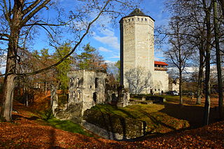
Põltsamaa is a town in Põltsamaa Parish, Jõgeva County, Estonia. The town stands on the Põltsamaa River, and it features a 13th-century castle.

<span class="mw-page-title-main">Türi</span> Town in Estonia

Türi is a town in Järva County, Estonia. It is the administrative centre of Türi Parish. Since 2000, Türi is known as the "spring capital" of Estonia. It has a railway station on the Tallinn - Viljandi railway line operated by Elron.

<span class="mw-page-title-main">Mustamäe</span> District of Tallinn, Estonia

Mustamäe is one of the 8 administrative districts of Tallinn, the capital of Estonia. The smallest by area, it is at the same time the second largest district by population with 66,305 inhabitants . It is located 5 km from the centre of Tallinn and is bordered by the districts of Haabersti, Nõmme, and Kristiine. Local housing is mostly represented by panel blocks of flats five to nine storeys high, built in the 1960 to 1970s.

<span class="mw-page-title-main">Kiviõli</span> Town in Estonia

Kiviõli is an industrial town in Ida-Viru County, Estonia, established in 1922. The main industry in the town is oil shale mining, which gives the town its name.

<span class="mw-page-title-main">Nõmme</span> District of Tallinn, Estonia

Nõmme is one of the eight administrative districts of Tallinn, the capital of Estonia. It has a population of 39,422 and covers an area of 28 km2 (11 sq mi), population density is 1,407.9/km2 (3,647/sq mi). The district is largely a middle-class suburban area, mostly consisting of listed private homes from the 1920s and 1930s and is sometimes referred to as the "Forest Town."

<span class="mw-page-title-main">Pirita</span> District of Tallinn, Estonia

Pirita is one of the eight administrative districts of Tallinn, the capital of Estonia.

<span class="mw-page-title-main">Haabersti</span> District of Tallinn, Estonia

Haabersti is one of the 8 administrative districts of Tallinn, the capital of Estonia.

<span class="mw-page-title-main">Lasnamäe</span> District of Tallinn

Lasnamäe is the most populous administrative district of Tallinn, the capital of Estonia. The district's population is about 119,000, the majority of which is Russian-speaking. Local housing is mostly represented by 5–16 stories high panel blocks of flats, built in the 1970–1990s.

<span class="mw-page-title-main">Kesklinn, Tallinn</span> District of Tallinn, Estonia

Kesklinn is one of the 8 administrative districts of Tallinn, the capital of Estonia. It is situated on the Tallinn Bay and bordered to the northwest by the district of Põhja-Tallinn, to the west by Kristiine, to the southwest by Nõmme, to the east by Lasnamäe and Pirita, and to the south by Rae Parish, beyond Lake Ülemiste. The island of Aegna, located in the Tallinn Bay, also falls within this administrative district. Kesklinn has an area of 30.6 km2 (11.8 sq mi) and a population of 57,731 ; population density is 1,886.6/km2 (4,886/sq mi).

<span class="mw-page-title-main">Põhja-Tallinn</span> District of Tallinn

Põhja-Tallinn is one of the eight administrative districts of Tallinn, the capital of Estonia.
<span class="mw-page-title-main">Tamsalu</span> Town in Estonia

Tamsalu is a town in Tapa Parish, Lääne-Viru County, Estonia.

References

  1. 1 2 "Tallinna elanike arv" (in Estonian). Tallinn City Government. Retrieved 27 November 2014.
  2. Niin, Jaan (21 March 2007). "Rootsi kuninganna Kristina" (in Estonian). Kesknädal. Archived from the original on 22 September 2013. Retrieved 30 May 2012.
  3. 1 2 2000. aasta rahva ja eluruumide loendus (PDF) (in Estonian and English). Tallinn: Statistikaamet. 2001. pp. 69, 78. ISBN   9985-74-167-6.
  4. "RL0429: RAHVASTIK RAHVUSE, SOO, VANUSERÜHMA JA ELUKOHA JÄRGI, 31. DETSEMBER 2011". Estonian Statistical Database (in Estonian).
  5. "RL21429: RAHVASTIK RAHVUSE, SOO, VANUSERÜHMA JA ELUKOHA (HALDUSÜKSUS) JÄRGI, 31. DETSEMBER 2021". Estonian Statistical Database (in Estonian).