Kristine M. Larson

Last updated

Kristine M. Larson
Kristine M Larson (cropped).jpg
Born
Alma mater
Known for Geodesy
Scientific career
Institutions

Kristine Marie Larson is an American academic. She is Emeritus Professor of Aerospace Engineering at the University of Colorado Boulder. Her research considers the development of algorithms for high-precision Global Positioning System (GPS) data analysis. She was the first to demonstrate that GPS could be used to detect seismic waves. She was awarded the 2015 European Geosciences Union Christiaan Huygens Medal.

Contents

Early life and education

Larson was born in Southern California. [1] Her father Valdemar F. Larson, "Swede", worked on the Deep Sea Drilling Project. [2] She studied engineering science and mechanics at Harvard University and graduated in 1985. Larson joined the University of California, San Diego for her doctoral studies, and earned a PhD in geophysics at the Scripps Institution of Oceanography in 1990. [1] Her dissertation evaluated the accuracy of the Global Positioning System (GPS) and was supervised by Duncan Agnew. [3] She was a member of the technical staff at the Jet Propulsion Laboratory, where she worked with the team that developed the GPS infrared positioning system, GIPSY. [1] [3]

Research and career

Larson was appointed to the faculty at the University of Colorado Boulder in 1990. [3] She developed new algorithms for the analysis of Global Positioning System (GPS) data. [4] She used GPS to identify plate velocities, boundary zone deformation and ice sheet motion. [3] She completed a visiting professorship at the Goddard Space Flight Center. Larson started to develop GPS for new applications in geoscience in 2000. She led a team of scientists that was the first to demonstrate that GPS could be used to detect seismic waves in 2003. [5] [6] [7] Her approach was used to evaluate earthquake triggering near the Denali rupture zone. GPS seismology is now used routinely in earth surveillance, including in the monitoring of tsunamis as well as in seismic source models. [5]

Larson has also worked on hydrogeodesy, as well as advising the US Federal Government on geodetic infrastructure. [8] Larson noticed that there were errors caused by the interference of GPS signals, which correlated with the water content in the surfaces close to the receiving antenna. [4] She showed that geodetic GPS receivers can be used to detect the water content of soil, as well as the depth of snow, snow water equivalent, and vegetation water content. She first demonstrated this capability in 2012, when she transformed a GPS network to be capable of interferometric reflectometry (GPS IR). GPS-IR was used in the Earthscope Plate Boundary Observatory. [4]

Larson also showed that it is possible to measure sea level changes, which allows the monitoring of subsidence and ground motion caused by earthquakes. These GPS receivers act as tide gauges, and can be tied to a terrestrial reference frame. She used them to monitor tidal levels in Kachemak Bay, and found that GPS was in good agreement with records from traditional tide gauges. [4] Larson showed that the strength of the GPS signal is correlated to the density of volcanic ash. [9]

In 2015 she became the first woman to win the European Geosciences Union Christiaan Huygens Medal. [10] In 2017 she became a Humboldt Fellow at GFZ German Research Centre for Geosciences. She became an Emeritus Professor at the University of Colorado Boulder in 2018. [11]

Awards and honours

Selected publications

Related Research Articles

<span class="mw-page-title-main">Geodesy</span> Science of the geometric shape, orientation in space, and gravitational field of Earth

Geodesy is the Earth science of accurately measuring and understanding Earth's figure, orientation in space, and gravity. The field also incorporates studies of how these properties change over time and equivalent measurements for other planets. Geodynamical phenomena, including crustal motion, tides and polar motion, can be studied by designing global and national control networks, applying space geodesy and terrestrial geodetic techniques and relying on datums and coordinate systems. The job title is geodesist or geodetic surveyor.

<span class="mw-page-title-main">Geophysics</span> Physics of the Earth and its vicinity

Geophysics is a subject of natural science concerned with the physical processes and physical properties of the Earth and its surrounding space environment, and the use of quantitative methods for their analysis. The term geophysics sometimes refers only to solid earth applications: Earth's shape; its gravitational and magnetic fields; its internal structure and composition; its dynamics and their surface expression in plate tectonics, the generation of magmas, volcanism and rock formation. However, modern geophysics organizations and pure scientists use a broader definition that includes the water cycle including snow and ice; fluid dynamics of the oceans and the atmosphere; electricity and magnetism in the ionosphere and magnetosphere and solar-terrestrial physics; and analogous problems associated with the Moon and other planets.

<span class="mw-page-title-main">Figure of the Earth</span> Size and shape used to model the Earth for geodesy

Figure of the Earth is a term of art in geodesy that refers to the size and shape used to model Earth. The size and shape it refers to depend on context, including the precision needed for the model. A sphere is a well-known historical approximation of the figure of the Earth that is satisfactory for many purposes. Several models with greater accuracy have been developed so that coordinate systems can serve the precise needs of navigation, surveying, cadastre, land use, and various other concerns.

<span class="mw-page-title-main">Satellite laser ranging</span>

In satellite laser ranging (SLR) a global network of observation stations measures the round trip time of flight of ultrashort pulses of light to satellites equipped with retroreflectors. This provides instantaneous range measurements of millimeter level precision which can be accumulated to provide accurate measurement of orbits and a host of important scientific data. The laser pulse can also be reflected by the surface of a satellite without a retroreflector, which is used for tracking space debris.

<span class="mw-page-title-main">GRACE and GRACE-FO</span> Joint American-German space mission to map Earths gravitational field

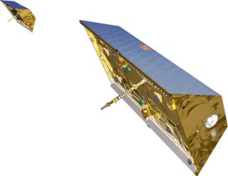
The Gravity Recovery and Climate Experiment (GRACE) was a joint mission of NASA and the German Aerospace Center (DLR). Twin satellites took detailed measurements of Earth's gravity field anomalies from its launch in March 2002 to the end of its science mission in October 2017. The GRACE Follow-On (GRACE-FO) is a continuation of the mission on near-identical hardware, launched in May 2018.

<span class="mw-page-title-main">Satellite geodesy</span> Measurement of the Earth using satellites

Satellite geodesy is geodesy by means of artificial satellites—the measurement of the form and dimensions of Earth, the location of objects on its surface and the figure of the Earth's gravity field by means of artificial satellite techniques. It belongs to the broader field of space geodesy. Traditional astronomical geodesy is not commonly considered a part of satellite geodesy, although there is considerable overlap between the techniques.

<span class="mw-page-title-main">International Union of Geodesy and Geophysics</span> International non-governmental organization

The International Union of Geodesy and Geophysics is an international non-governmental organization dedicated to the scientific study of Earth and its space environment using geophysical and geodetic techniques.

UNAVCO is a non-profit university-governed consortium that facilitates geoscience research and education using Geodesy. UNAVCO is funded by the National Science Foundation (NSF) and the National Aeronautics and Space Administration (NASA) to support geoscience research around the world. UNAVCO operates the GAGE Facility on behalf of the NSF and NASA. As a university-governed consortium, UNAVCO supports the goals of the academic scientific community. UNAVCO has 120 US academic members and supports over 110 organizations globally as associate members.

<span class="mw-page-title-main">Peter Fox (professor)</span> American data scientist (1959–2021)

Peter Arthur Fox was a data science and Semantic eScience researcher at Rensselaer Polytechnic Institute (RPI), United States. He was a Tetherless World Constellation chair and professor of Earth and Environmental Science, Computer Science and Cognitive Science, and director of the Information Technology and Web Science Program at RPI. He was known for defining informatics and data science in earth sciences, bringing Semantic Web research to that community, as well as defining the sun-earth connection research agenda and co-convening the community. Fox was born in Devonport, Tasmania, Australia and resided in Troy, NY, United States until his death on 27 March 2021, at the age of 61.

<span class="mw-page-title-main">Diane McKnight</span>

Diane McKnight is a professor of civil, environmental, and architectural engineering at the University of Colorado Boulder and a fellow at the Institute of Arctic and Alpine Research (INSTAAR). McKnight is a founding principal investigator of the National Science Foundation's Long-Term Ecological Research (LTER) program in the McMurdo Dry Valleys of Antarctica.

Joan S. Gomberg is a research geophysicist at the United States Geological Survey. She serves as an adjunct professor at the University of Washington. She is interested in subduction zone science, and studies how earthquakes trigger each other and how faults can slip. Gomberg is a Fellow of the American Geophysical Union. She was the first person to demonstrate how dynamic stress associated with seismic waves can trigger other earthquakes.

Alik Ismail-Zadeh is a mathematical geophysicist known for his contribution to computational geodynamics and natural hazard studies, pioneering work on data assimilation in geodynamics as well as for outstanding service to the Earth and space science community. He is Senior Research Fellow at the Karlsruhe Institute of Technology in Germany.

<span class="mw-page-title-main">Véronique Dehant</span> Belgian geodesist and geophysicist

Véronique Dehant is a Belgian geodesist and geophysicist. She specializes in modeling the deformation of the Earth's interior in response to forcing from the Sun, Moon, and the Earth's rotation. She has used similar techniques to study Mercury, Venus, Mars and icy satellites of the outer planets. She primarily works at the Royal Observatory of Belgium, but also serves as an Extraordinary Professor at the Université Catholique de Louvain.

Éric Calais is a French geologist-geophysicist, born in 1964, internationally recognized practitioner of high-precision spatial geodesy and a pioneer in its applications to measure seismic deformations at the boundaries of tectonic plates and in their interiors.

<span class="mw-page-title-main">Laura Wallace</span> American geophysicist

Laura Martin Wallace is a geodetic principal scientist who works between the University of Texas at Austin and GNS Science in New Zealand. She was elected Fellow of the Royal Society Te Apārangi in 2018.

<span class="mw-page-title-main">Whitney Maria Behr</span> Geologist

Whitney Maria Behr is an American Earth Scientist known for her contributions to understanding mechanics and kinematics of deformation in Earth's lithosphere. She was educated in the United States following which she held academic positions there. Since 2018, she has been the chair of the Structural Geology & Tectonics Group in the Geological Institute at ETH Zürich.

The Ann and H.J. Smead Department of Aerospace Engineering Sciences is a department within the College of Engineering & Applied Science at the University of Colorado Boulder, providing aerospace education and research. Housed primarily in the Aerospace Engineering Sciences building on the university's East Campus in Boulder, it awards baccalaureate, masters, and PhD degrees, as well as certificates, graduating approximately 225 students annually. The Ann and H.J. Smead Department of Aerospace Engineering Sciences is ranked 10th in the nation in both undergraduate and graduate aerospace engineering education among public universities by US News & World Report.

The Christiaan Huygens Medal, named after the mathematician and natural philosopher Christiaan Huygens, is a prize awarded by the European Geosciences Union to promote excellence in geosciences and space science.

Annie Souriau is a seismologist known for her research into Earth's inner and outer cores.

Anne Sheehan is a geologist known for her research using seismometer data to examine changes in the Earth's crust and mantle.

References

  1. 1 2 3 "Background". Kristine M. Larson. October 4, 2015. Retrieved June 25, 2019.
  2. "Deep Ocean Drill Bits-Deep Sea Drilling Project Operations Manager". library.ucsd.edu. 1970. Retrieved June 25, 2019.
  3. 1 2 3 4 5 "Larson Receives Geodesy Section Award". Honors Program. Retrieved June 25, 2019.
  4. 1 2 3 4 "User Profile: Dr. Kristine M. Larson | Earthdata". earthdata.nasa.gov. Retrieved June 25, 2019.
  5. 1 2 Larson, Kristine M. (March 1, 2009). "GPS seismology". Journal of Geodesy. 83 (3): 227–233. Bibcode:2009JGeod..83..227L. doi:10.1007/s00190-008-0233-x. ISSN   1432-1394. S2CID   8131084.
  6. Axelrad, Penina. "Larson Receives Geodesy Section Award". American Geophysical Union. Retrieved June 30, 2019.
  7. "GPS tracks seismic waves" . New Civil Engineer. July 1, 2003. Retrieved June 30, 2019.
  8. Read "Precise Geodetic Infrastructure: National Requirements for a Shared Resource" at NAP.edu.
  9. Nestler, Ralf (April 19, 2017). ""Funny Signals" - Kristine Larson uses GPS data for detecting soil moisture and measuring volcanic ash plumes". GFZ German Research Centre for Geosciences . Retrieved June 30, 2019.
  10. "Christiaan Huygens Medal". European Geosciences Union (EGU). Retrieved June 25, 2019.
  11. "Kristine Larson". Ann and H.J. Smead Aerospace Engineering Sciences. July 29, 2014. Retrieved June 25, 2019.
  12. 1 2 David. "Creativity Prize (Co-Winners)". psipw.org. Retrieved June 25, 2019.
  13. "Bowie Lectures". Geodesy Section. Retrieved June 25, 2019.
  14. "Jubilee professors | Chalmers". www.chalmers.se. Retrieved June 25, 2019.
  15. "Fellows Alphabetical List". Honors Program. Retrieved June 25, 2019.
  16. "BFA". Kristine M. Larson. December 23, 2015. Retrieved June 25, 2019.
  17. "Kristine M. Larson". European Geosciences Union (EGU). Retrieved June 25, 2019.
  18. "Prof. Dr. Kristine M. Larson". www.humboldt-foundation.de. Retrieved June 25, 2019.
  19. "Science journalist, geodesist and a physicist named Chalmers honorary doctors of 2017 | Chalmers". www.chalmers.se. Retrieved June 25, 2019.
  20. "Breakthrough GPS work earns 2017 Governor's Award". Ann and H.J. Smead Aerospace Engineering Sciences. August 18, 2017. Retrieved June 25, 2019.
  21. "Kristine Larson to share groundbreaking GPS work on Dec. 5 as Distinguished Research Lecturer". Research & Innovation Office. November 13, 2018. Retrieved June 25, 2019.