P'anmun Station is a railway station located in the Kaesŏng Industrial Region, North Hwanghae province, North Korea. It is on located on the P'yŏngbu Line, which was formed from part of the Kyŏngŭi Line to accommodate the shift of the capital from Seoul to P'yŏngyang.
Pongdong Station is a railway station located in Pongsan County, North Hwanghae province, North Korea. It is on located on the P'yŏngbu Line, which was formed from part of the Kyŏngŭi Line to accommodate the shift of the capital from Seoul to P'yŏngyang; though this line physically connects P'yŏngyang to Pusan via Dorasan, in operational reality it ends at Kaesŏng due to the Korean Demilitarized Zone.

Sonha Station is a railway station located in Kaesŏng-t'ŭkkŭpsi, North Hwanghae province, North Korea. It is on located on the P'yŏngbu Line, which was formed from part of the Kyŏngŭi Line to accommodate the shift of the capital from Seoul to P'yŏngyang; though this line physically connects P'yŏngyang to Pusan via Dorasan, in operational reality it ends at Kaesŏng due to the Korean Demilitarized Zone.
Kaesŏng Station is a railway station located in Kaesŏng, North Hwanghae province, North Korea. It is on located on the P'yŏngbu Line, which was formed from part of the Kyŏngŭi Line to accommodate the shift of the capital from Seoul to P'yŏngyang; though this line physically connects P'yŏngyang to Pusan via Dorasan, in operational reality trains terminate here due to the Korean Demilitarized Zone.
Kaep'ung Station is a railway station located in Kaep'ung-ŭp, Kaep'ung County, North Hwanghae province, North Korea. It is on located on the P'yŏngbu Line, which was formed from part of the Kyŏngŭi Line to accommodate the shift of the capital from Seoul to P'yŏngyang; though this line physically connects P'yŏngyang to Pusan via Dorasan, in operational reality it ends at Kaesŏng due to the Korean Demilitarized Zone.
Ryŏhyŏn Station is a railway station located in Ryŏhyŏl-li, Kaep'ung County, North Hwanghae province, North Korea. It is on located on the P'yŏngbu Line, which was formed from part of the Kyŏngŭi Line to accommodate the shift of the capital from Seoul to P'yŏngyang; though this line physically connects P'yŏngyang to Pusan via Dorasan, in operational reality it ends at Kaesŏng due to the Korean Demilitarized Zone.
Hanp'o Station is a railway station located in Hanp'o-ri, P'yŏngsan County, North Hwanghae province, North Korea. It is on located on the P'yŏngbu Line, which was formed from part of the Kyŏngŭi Line to accommodate the shift of the capital from Seoul to P'yŏngyang; though this line physically connects P'yŏngyang to Pusan via Dorasan, in operational reality it ends at Kaesŏng due to the Korean Demilitarized Zone.
Taebaeksansŏng Station is a railway station in Sansŏng-ri, P‘yŏngsan County, North Hwanghae province, North Korea. It is on the P'yŏngbu Line, which was formed from part of the Kyŏngŭi Line to accommodate the shift of the capital from Seoul to P'yŏngyang. Though this line physically connects P'yŏngyang to Pusan via Dorasan, in operational reality it ends at Kaesŏng due to the Korean Demilitarized Zone.
Mulgae Station is a railway station located in P‘yŏngsan County, North Hwanghae province, North Korea. It is on located on the P'yŏngbu Line, which was formed from part of the Kyŏngŭi Line to accommodate the shift of the capital from Seoul to P'yŏngyang; though this line physically connects P'yŏngyang to Pusan via Dorasan, in operational reality it ends at Kaesŏng due to the Korean Demilitarized Zone.
Sokhyon Station is a railway station located in Sinmak-ri, Sŏhŭng Country, North Hwanghae province, North Korea. It is on located on the P'yŏngbu Line, which was formed from part of the Kyŏngŭi Line to accommodate the shift of the capital from Seoul to P'yŏngyang; though this line physically connects P'yŏngyang to Pusan via Dorasan, in operational reality it ends at Kaesŏng due to the Korean Demilitarized Zone.
Sŏhŭng Station is a railway station located in Sŏhŭng-ŭp, Sŏhŭng Country, North Hwanghae province, North Korea. It is on located on the P'yŏngbu Line, which was formed from part of the Kyŏngŭi Line to accommodate the shift of the capital from Seoul to P'yŏngyang; though this line physically connects P'yŏngyang to Pusan via Dorasan, in operational reality it ends at Kaesŏng due to the Korean Demilitarized Zone.
Munmu Station is a railway station located in Munmu-ri, Sŏhŭng County, North Hwanghae province, North Korea. It is on located on the P'yŏngbu Line, which was formed from part of the Kyŏngŭi Line to accommodate the shift of the capital from Seoul to P'yŏngyang; though this line physically connects P'yŏngyang to Pusan via Dorasan, in operational reality it ends at Kaesŏng due to the Korean Demilitarized Zone.
Hŭngsu Station is a railway station located in Hŭngsu-ri, Pongsan County, North Hwanghae province, North Korea. It is on located on the P'yŏngbu Line, which was formed from part of the Kyŏngŭi Line to accommodate the shift of the capital from Seoul to P'yŏngyang; though this line physically connects P'yŏngyang to Pusan via Dorasan, in operational reality it ends at Kaesŏng due to the Korean Demilitarized Zone.
Ch'ŏnggye Station is a railway station located in Pongsan County, North Hwanghae province, North Korea. It is on located on the P'yŏngbu Line, which was formed from part of the Kyŏngŭi Line to accommodate the shift of the capital from Seoul to P'yŏngyang; though this line physically connects P'yŏngyang to Pusan via Dorasan, in operational reality it ends at Kaesŏng due to the Korean Demilitarized Zone.
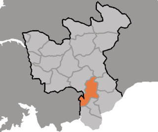
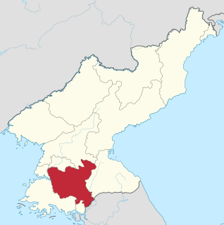
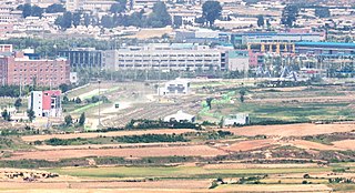
Sariwŏn Ch'ŏngnyŏn Station is the central railway station of Sariwŏn, North Hwanghae province, North Korea. It is on located on the P'yŏngbu Line, which was formed from part of the Kyŏngŭi Line to accommodate the shift of the capital from Seoul to P'yŏngyang; though this line physically connects P'yŏngyang to Pusan via Dorasan, in operational reality it ends at Kaesŏng due to the Korean Demilitarized Zone. It is also the northern terminus of the Hwanghae Ch'ŏngnyŏn Line.
Chŏngbang Station is a railway station located in Sariwŏn, North Hwanghae province, North Korea. It is on located on the P'yŏngbu Line, which was formed from part of the Kyŏngŭi Line to accommodate the shift of the capital from Seoul to P'yŏngyang; though this line physically connects P'yŏngyang to Pusan via Dorasan, in operational reality it ends at Kaesŏng due to the Korean Demilitarized Zone.
Kindŭng Station is a railway station in Ryonggung-ri, Hwangju County, North Hwanghae Province, North Korea. It is on located on the P'yŏngbu Line, which was formed from part of the Kyŏngŭi Line to accommodate the shift of the capital from Seoul to P'yŏngyang; though this line physically connects P'yŏngyang to Pusan via Dorasan, in operational reality it ends at Kaesŏng due to the Korean Demilitarized Zone.
Hŭkkyo Station is a railway station located in Hŭkkyo-ri, Hwangju county, North Hwanghae province, North Korea. It is on located on the P'yŏngbu Line, which was formed from part of the Kyŏngŭi Line to accommodate the shift of the capital from Seoul to P'yŏngyang; though this line physically connects P'yŏngyang to Pusan via Dorasan, in operational reality it ends at Kaesŏng due to the Korean Demilitarized Zone.

Pyongyang Station is the central railway station of P'yŏngyang, North Korea. It is located in Yŏkchŏn-dong, Chung-guyŏk.
Tongp'yŏngyang Station is a railway station located in P'yŏngyang, North Korea, on the P'yŏngdŏk Line of the Korean State Railway.