LaPlanche Street

Last updated
A view from LaPlanche Street near Sackville, NB LaPlancheCBC.jpg
A view from LaPlanche Street near Sackville, NB

LaPlanche Street is the historic connector between Nova Scotia and New Brunswick, Canada. Located on the Isthmus of Chignecto, LaPlanche crosses the Tantramar Marshes between Amherst, NS and Sackville, NB. Historically, it hosted the key forts of peninsular Nova Scotia and continental Acadia and witnessed the Battle of Fort Beauséjour, the key battle between the two colonies during the Seven Years' War, and the Battle of Fort Cumberland of the American Revolutionary War.

Contents

History

Fort Beausejour - Fort Cumberland National Historic Site of Canada Beausejour2006.jpg
Fort Beauséjour - Fort Cumberland National Historic Site of Canada

When originally settled by the Acadians, the Tantramar community was called Beaubassin. La Planche means "the plank" and describes a plank-bridge route over what is now also called Laplanche River. This would eventually extend into the principal route between Continental Acadia (New Brunswick) and (then) Peninsular Acadia (Nova Scotia).

1700s

As the major throughway between two rival colonies, British Nova Scotia and Acadia, early LaPlanche was guarded by two forts. In 1750 Fort Lawrence (located in the present-day community called Fort Lawrence on the Missaguash River, just west of Amherst, NS) was built by British troops on LaPlanche Street to defend the border of Nova Scotia. In response, the French built Fort Beauséjour on Beauséjour ridge (now Aulac Ridge). In the Battle of Fort Beauséjour (1755), the opening mark of the French and Indian War, Fort Beauséjour fell to the British, led by Lieutenant-Colonel Monckton. Recognizing its superiority, the British burned their own Fort Lawrence and moved into Fort Beauséjour, renaming it Fort Cumberland. [1] Acadia's Great Upheaval began in Beaubassin immediately after this battle.

The southern dock of the Chignecto Ship Railway, on the Missaguash River, Fort Lawrence Shiprailwaydock.jpg
The southern dock of the Chignecto Ship Railway, on the Missaguash River, Fort Lawrence

Two decades later, Jonathan Eddy tried to bring the American Revolutionary War to Nova Scotia with Battle of Fort Cumberland. Eddy and his militia of 400 men stormed the fort in 1776. The British successfully defended and thus ensured loyalty to the British throne for Nova Scotia during the revolution. [2] In the decades to follow Amherst, Sackville and Aulac (LaPlanche Street's midpoint) would be populated by waves of English-speaking settlers, namely the New England Planters and the Yorkshire settlers. [3]

1800s

Maleable Iron Works, LaPlanche Street, Amherst, Nova Scotia Malleable Iron Works.jpg
Maleable Iron Works, LaPlanche Street, Amherst, Nova Scotia

La Planche Street would also serve as the southern end of the Chignecto Ship Railway - had it been completed. Designed by Henry Ketchum, the ship railway would have been one of the most impressive engineering feats of its day. The railway would use two steam locomotives to transport small cargo and passenger ships between the upper Bay of Fundy and the Northumberland Strait, with the potential to reduce the 800 kilometre journey-by-sea around Nova Scotia to a mere 24 kilometres. It ran between Fort Lawrence, Nova Scotia, outside Amherst, and Tidnish on the, Northumberland Strait. In 1891, federal funding was withdrawn and the project never saw fruition. [4]

1900s

The historic Hampton Diner. Hampton Diner NS.jpg
The historic Hampton Diner.

Both Sackville and Amherst would develop into industrial towns. On the western end of LaPlanche Street (now called Bridge Street, NB Route 106) was Sackville's downtown core. On the eastern end (still called LaPlanche Street, NS Route 204) was Amherst's old industrial park immediately before its downtown. The LaPlanche industrial park manufactured railway passenger and freight cars, boilers, engines, automobile parts and generator plants and was home to the Rhodes Curry Company, the Canadian Car and Foundry Co., Robb Engineering Co., Malleable Iron Co., McLean Milling Co., Oxford Worsted Co., Hewson Woolen Mills, Eastern Pants Co., M. Shane & Co., News Publishing Co., and E. Biden & Sons. [5] As more advanced industrial centres developed elsewhere, LaPlanche's industry fell into disuse. In the 1960s it was replaced by a newer, smaller industrial park on the Trans-Canada Highway.

As the major throughway between mainland Canada and Nova Scotia and Prince Edward Island, LaPlanche hosted many tourist-oriented businesses. It sustained three diners famous in local memory: Mel's Tea Room (Sackville), Eva's Place (Aulac), and The Hampton Diner (Fort Lawrence). Nova Scotia built its Tourist Welcome Centre on LaPlanche Street in Fort Lawrence, placing it between the east and west-bound lanes.

Now

The 1960s saw the Trans-Canada Highway system being upgraded to four-lane expressways. This included a new route between Sackville and Amherst running roughly parallel to LaPlanche Street (Nova Scotia Highway 104-Nova Scotia Trunk 2 meeting New Brunswick Highway 2). Services inevitably became concentrated at the Aulac exit, where the PEI route branches, and LaPlanche Street's economy began to fade. Various bridges and sections of LaPlanche Street were dismantled and the street was divided into three disconnected segments. The Sackville segment (Bridge Street) remains vital, while Aulac and Amherst's host numerous dilapidated shops, plants and motels, and serve the fringe economy and culture of the two communities, masking the centuries of history for which it was stage.

Geography

Chignecto Isthmus

An historic map of the Chignecto Isthmus. Chignecto historic map.jpg
An historic map of the Chignecto Isthmus.

LaPlanche Street traverses the low-lying, southern edge of the Chignecto Isthmus, which connects Nova Scotia with New Brunswick and thus mainland Canada. The Isthmus runs from the Petitcodiac River in Dieppe, New Brunswick to Amherst, Nova Scotia and has as its two oceanic boundaries the Chignecto Bay, a sub-basin of the Bay of Fundy, and the Northumberland Strait, an arm of the Gulf of St. Lawrence. The isthmus is made up of the Tantramar Marshes, at sea level, and four ridges that emerge from the Bay of Fundy and rise north-easterly: [6]

The Missaguash River. Missaguash River.jpg
The Missaguash River.

Tantramar Marshes

The Tantramar Marshes were once salt marshes that stretched 10 km inland from the Chignecto Bay. Diked by the Acadians, they are now fertile hay fields and a National Wildlife Area. The marshes are drained by four tidal rivers:

Related Research Articles

<span class="mw-page-title-main">Sackville, New Brunswick</span> Place in New Brunswick, Canada

Sackville is a former town in southeastern New Brunswick, Canada. It held town status prior to 2023 and is now part of the town of Tantramar.

<span class="mw-page-title-main">Memramcook</span> Village in New Brunswick, Canada

Memramcook, sometimes also spelled Memramcouke or Memramkouke, is a village in Westmorland County, New Brunswick, Canada. Located in south-eastern New Brunswick, the community is predominantly people of Acadian descent who speak the Chiac derivative of the French language. An agricultural village, it has a strong local patrimony, key to the history of the region. It was home to Mi'kmaqs for many years and was the arrival site of Acadians in 1700. A large part of these Acadians were deported in 1755, but the village itself survived.

<span class="mw-page-title-main">Chignecto Bay</span>

Chignecto Bay is an inlet of the Bay of Fundy located between the Canadian provinces of New Brunswick and Nova Scotia and separated from the waters of the Northumberland Strait by the Isthmus of Chignecto. It is a unit within the greater Gulf of Maine Watershed. Chignecto Bay forms the northeastern part of the Bay of Fundy which splits at Cape Chignecto and is delineated on the New Brunswick side by Martin Head. Chignecto Bay is a Ramsar site.

<span class="mw-page-title-main">Tantramar Marshes</span>

The Tantramar Marshes, also known as the Tintamarre National Wildlife Area, is a tidal saltmarsh around the Bay of Fundy on the Isthmus of Chignecto. The area borders between Route 940, Route 16 and Route 2 near Sackville, New Brunswick. The government of Canada proposed the boundaries of the Tantramar Marshes in 1966 and was declared a National Wildlife Area in 1978.

The Isthmus of Chignecto is an isthmus bordering the Maritime provinces of New Brunswick and Nova Scotia that connects the Nova Scotia peninsula with North America.

Beaubassin was an important Acadian village and trading centre on the Isthmus of Chignecto in what is now Nova Scotia, Canada. The area was a significant place in the geopolitical struggle between the British and French empires. It was established in the 1670s on an upland close to an extensive area of saltwater marsh. Settlers reclaimed the land to engage in cattle ranching and trade.

<span class="mw-page-title-main">Fort Beauséjour</span> Fort in Aulac, New Brunswick, Canada

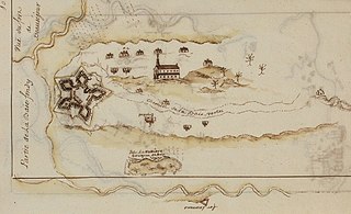
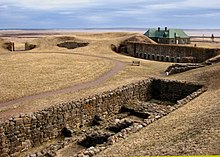
Fort Beauséjour, renamed Fort Cumberland in 1755, is a large, five-bastioned fort on the Isthmus of Chignecto in eastern Canada, a neck of land connecting the present-day province of New Brunswick with that of Nova Scotia. The site was strategically important in Acadia, a French colony that included primarily the Maritimes, the eastern part of Quebec, and northern Maine of the later United States. The fort was built by the French from 1751 to 1752. They surrendered it to the British in 1755 after their defeat in the Battle of Fort Beauséjour, during the Seven Years' War. The British renamed the structure as Fort Cumberland. The fort was strategically important throughout the Anglo-French rivalry of 1749–63, known as the French and Indian Wars by British colonists. Less than a generation later, it was the site of the 1776 Battle of Fort Cumberland, when the British forces repulsed sympathisers of the American Revolution.

<span class="mw-page-title-main">Fort Lawrence (Nova Scotia)</span>

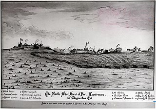
Fort Lawrence was a British fort built during Father Le Loutre's War and located on the Isthmus of Chignecto.

<span class="mw-page-title-main">Battle of Fort Beauséjour</span> 1755 battle of the French and Indian War

The Battle of Fort Beauséjour was fought on the Isthmus of Chignecto and marked the end of Father Le Loutre's War and the opening of a British offensive in the Acadia/Nova Scotia theatre of the Seven Years' War, which would eventually lead to the end of the French colonial empire in North America. The battle also reshaped the settlement patterns of the Atlantic region, and laid the groundwork for the modern province of New Brunswick.

<span class="mw-page-title-main">Robert Monckton</span> Army officer and colonial administrator in British North America

Lieutenant-General Robert Monckton was an officer of the British Army and colonial administrator in British North America. He had a distinguished military and political career, being second in command to General James Wolfe at the battle of Quebec and later being named the Governor of the Province of New York. Monckton is also remembered for his role in a number of other important events in the French and Indian War, most notably the capture of Fort Beauséjour in Acadia, and the island of Martinique in the West Indies, as well as for his role in the deportation of the Acadians from British controlled Nova Scotia and also from French-controlled Acadia. The city of Moncton, New Brunswick, and Fort Monckton in Port Elgin, New Brunswick, are named for him. A second more important Fort Monckton in Gosport, England, is also named for him. It remains an active military establishment, and currently houses the British Secret Intelligence Service (MI6) training section. Monckton sat in the British House of Commons between 1774 and 1782. Although never legally married, he raised and was survived by three sons and a daughter.

<span class="mw-page-title-main">Fort Gaspareaux</span>

Fort Gaspareaux was a French fort at the head of Baie Verte near the mouth of the Gaspareaux River and just southeast of the modern community of Strait Shores, New Brunswick, Canada, on the Isthmus of Chignecto. It was built during Father Le Loutre's War and is now a National Historic Site of Canada overlooking the Northumberland Strait.

Aulac is a Canadian community in Westmorland County, New Brunswick. It is located between the college town of Sackville and the provincial border with Nova Scotia.

<span class="mw-page-title-main">Missaguash River</span>

The Missaguash River is a small Canadian river that forms the southern portion of the inter-provincial boundary between Nova Scotia and New Brunswick on the Isthmus of Chignecto. It had historic significance in the 18th century as the de facto border between French and English-controlled territories.

<span class="mw-page-title-main">History of New Brunswick</span>

The history of New Brunswick covers the period from the arrival of the Paleo-Indians thousands of years ago to the present day. Prior to European colonization, the lands encompassing present-day New Brunswick were inhabited for millennia by the several First Nations groups, most notably the Maliseet, Mi'kmaq, and the Passamaquoddy.

Fort Lawrence is a Canadian rural community located on the Isthmus of Chignecto in Cumberland County, Nova Scotia, which is named after Fort Lawrence.

<span class="mw-page-title-main">Jean-Louis Le Loutre</span>

Abbé Jean-Louis Le Loutre was a Catholic priest and missionary for the Paris Foreign Missions Society. Le Loutre became the leader of the French forces and the Acadian and Mi'kmaq militias during King George's War and Father Le Loutre's War in the eighteenth-century struggle for power between the French, Acadians, and Miꞌkmaq against the British over Acadia.

Mount Whatley is a community in the Canadian province of New Brunswick, located in Westmorland County on New Brunswick Highway 16. Mount Whatley is situated upon the Aulac Ridge, a prominent rise running west–east across the Tantramar Marshes on the Isthmus of Chignecto,on the shore of the Missaguash River which forms the southern part of the inter-provincial boundary with Nova Scotia.The community is linked by a small bridge to Fort Lawrence Nova Scotia.

<span class="mw-page-title-main">Sackville Parish, New Brunswick</span> Parish in New Brunswick, Canada

Sackville is a civil parish in Westmorland County, New Brunswick, Canada.

<span class="mw-page-title-main">Acadian Exodus</span> Flight and Relocation of Acadians during Father Le Loutres War

The Acadian Exodus happened during Father Le Loutre's War (1749–1755) and involved almost half of the total Acadian population of Nova Scotia deciding to relocate to French controlled territories. The three primary destinations were: the west side of the Mesagoueche River in the Chignecto region, Isle Saint-Jean and Île-Royale. The leader of the Exodus was Father Jean-Louis Le Loutre, whom the British gave the code name "Moses". Le Loutre acted in conjunction with Governor of New France, Roland-Michel Barrin de La Galissonière, who encouraged the Acadian migration. A prominent Acadian who transported Acadians to Ile St. Jean and Ile Royal was Joseph-Nicolas Gautier. The overall upheaval of the early 1750s in Nova Scotia was unprecedented. Present-day Atlantic Canada witnessed more population movements, more fortification construction, and more troop allocations than ever before in the region. The greatest immigration of the Acadians between 1749 and 1755 took place in 1750. Primarily due to natural disasters and British raids, the Exodus proved to be unsustainable when Acadians tried to develop communities in the French territories.

<span class="mw-page-title-main">Tantramar, New Brunswick</span> Town in New Brunswick, Canada

Tantramar is a town in the Canadian province of New Brunswick. It was formed through the 2023 New Brunswick local governance reforms.

References

  1. History: Fort Beauséjour – Fort Cumberland National Historic Site of Canada. Parks Canada, Government of Canada
  2. Ernest Clarke, The siege of Fort Cumberland, 1776, McGill Queen's University Press, 1995. pp. 215-
  3. Migration from Yorkshire to Nova Scotia
  4. Ircha M. C., "The Chignecto Ship Railway: a 19th century engineering innovation." Canadian Journal of Civil Engineering 19, 1 (1992): 164-177.
  5. The History of Amherst Archived 2009-05-22 at the Wayback Machine by J. A. Blanche. Cumberland Regional Library
  6. History of Chignecto Archived 2009-05-22 at the Wayback Machine , by W. C. Milner. "Cumberland Regional Library."