
Santander is a department of Colombia. Santander inherited the name of one of the nine original states of the United States of Colombia. It is located in the central northern part of the country, borders the Magdalena River to the east, Boyacá to the south and southeast, the Norte de Santander Department to the northeast, the Cesar Department to the north, the Bolivar and Antioquia Departments to the west. Its capital is the city of Bucaramanga.

Cesar Department or simply Cesar is a department of Colombia located in the north of the country in the Caribbean region, bordering to the north with the Department of La Guajira, to the west with the Department of Magdalena and Department of Bolivar, to the south with Department of Santander, to the east with the Department of North Santander, and further to the east with the country of Venezuela. The department capital city is Valledupar.

Valledupar is a city and municipality in northeastern Colombia. It is the capital of Cesar Department. Its name, Valle de Upar, was established in honor of the Amerindian cacique who ruled the valley; Cacique Upar. The city lies between the mountains of the Sierra Nevada de Santa Marta and the Serranía del Perijá to the borders of the Guatapurí and Cesar rivers.

Aracataca is a town and municipality and town located in the Department of Magdalena, in Colombia's Caribbean Region. Aracataca is a river town founded in 1885. The town stands beside a small river of the same name, the Aracataca river, that flows from the nearby Sierra Nevada de Santa Marta mountain range into the Ciénaga Grande de Santa Marta, a lagoon of the Caribbean Sea. Aracataca is 80 kilometres (50 mi) south of the Department capital Santa Marta. The town is best known as the birthplace of Nobel literature laureate Gabriel García Márquez.

Puerto Boyacá is a Colombian river-port town and municipality by the Magdalena River in the Boyacá Department, where is also considered a Special Trade Zone due to its port status. Its main industries are oil exploration and processing. In the 1980s and early 1990s, Puerto Boyacá was affected intensively by the Colombian Armed Conflict.
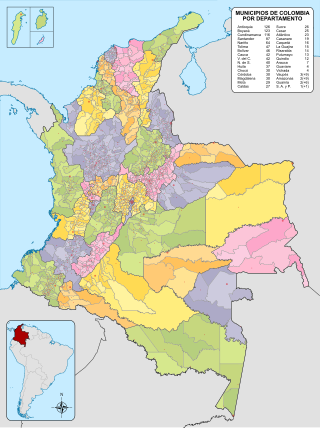
The municipalities of Colombia are decentralized subdivisions of the Republic of Colombia. Municipalities make up most of the departments of Colombia with 1,122 municipalities (municipios). Each one of them is led by a mayor (alcalde) elected by popular vote and represents the maximum executive government official at a municipality level under the mandate of the governor of their department which is a representative of all municipalities in the department; municipalities are grouped to form departments.

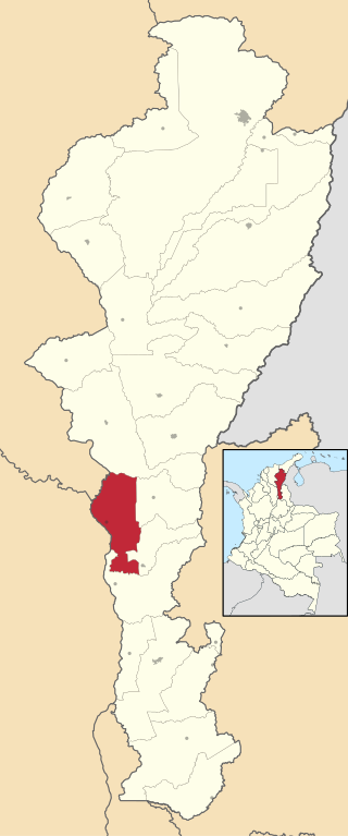
El Paso is a municipality in the Cesar Department of Colombia. El Paso is mostly known for having the second largest coal mine in Colombia, located in the corregimiento of La Loma.

Magangué is a municipality of Colombia in the Department of Bolivar. The town is located in the Magdalena River; 20 km north of the mouth of the Cauca River, the Magdalena River. According to projections, the city has a population of over 198,000 inhabitants, becoming the twenty-seventh largest city in Colombia, with about 800,000 inhabitants in the Association Sabana Metropolitan, making it the eighth largest metropolitan area in Colombia. It is the second largest city of the Department, and the ninth largest of the Caribbean Region. Magangué was home to the country's largest port, now badly damaged by the problems of political corruption. It has been shown that the city has great national potential, due to its strategic location.

Mompox or Mompós, officially Santa Cruz de Mompox, is a town and municipality in northern Colombia, in the Bolívar Department. The town initially grew from its proximity to the Magdalena river and has preserved much of its colonial character. It also played an important role in the liberation of South America from Spain. Today, Mompox depends upon tourism, fishing, and some commerce generated by the local cattle raising. The municipality has a population of 46,408 and is adjacent to the municipalities of Pinillos and San Fernando. The historic center of Mompox was made a UNESCO World Heritage Site in 1995, owing to its preserved colonial architecture and mixture of architectural styles.

San Juan del Cesar is a municipality and town located in the La Guajira Department, Colombia.

The Caribbean region of Colombia or Caribbean coast region is in the north of Colombia and is mainly composed of 8 departments located contiguous to the Caribbean. It's the second most populated region in the country after Andean Region with approximately 11 million residents according to the Colombian Census 2018. The area covers a total land area of 110,000 km2 (42,000 sq mi), including the Archipelago of San Andrés, Providencia and Santa Catalina in the Caribbean Sea.

Pueblo Bello, is a village and municipality in the northern region of the Department of Cesar, Colombia. It is located in the mountains of the Sierra Nevada de Santa Marta and is home to Amerindians pertaining to the Arhuaco ethnicity, whom consider Pueblo Bello a sanctuary but by the name of Arumake in their language. Pueblo Bello is the main producer of coffee in the Caribbean Region of Colombia.

Aguachica, is a small city and municipality in the southern region of the Cesar Department, Colombia. There is no historical support on the date of its foundation; however, August 16, 1748 has been chosen by the community. Saint Roch is the patron saint of the municipality and August 16 is the date on which the Catholic Church celebrates its festival.

Chimichagua is a city and municipality in the central region of the Department of Cesar, Colombia. Approximately one third of the municipality of Chimichagua is water. The municipality seat lies by the Cienaga de Zapatosa marshes.

La Guajira is a department of Colombia. It occupies most of the Guajira Peninsula in the northeast region of the country, on the Caribbean Sea and bordering Venezuela, at the northernmost tip of South America. The capital city of the department is Riohacha.

Astrea is a municipality and town of the Department of Cesar in northern Colombia.

Bosconia is a town and municipality in the Colombian Department of Cesar.
Tamalameque is a town and municipality in the Colombian Department of Cesar. It was originally the site of a Chimila settlement, Thamara. Tamalameque is located on the right bank of the Magdalena River and borders Chimichagua and Pailitas in the north, Pelaya in the east, La Gloria in the south and in the west the departments of Bolívar and Magdalena.

Regidor is a town and municipality located in the Bolívar Department, northern Colombia in a lowland area along the banks of the Magdalena River. The principal industry of Regidor is cultivation of Oil Palm. Many subsistence farmers have been pressured to sell their land to oil palm companies and to displace.

Gambote is a corregimiento in the northern part of the department of Bolívar, Colombia. It is part of the municipality of Arjona and has a population of 1,531 as of 2018. It is located approximately 39 km south of Cartagena. The town is situated on the banks of the Canal del Dique and is responsible for the administration of fresh water supply for the northern part of the department. The town is also known for the Gambote Bridge which cuts through the town.


