La Haute-Beaume

Last updated

La Haute-Beaume
Location of La Haute-Beaume
La Haute-Beaume
France location map-Regions and departements-2016.svg
Red pog.svg
La Haute-Beaume
Provence-Alpes-Cotes d'Azur region location map.svg
Red pog.svg
La Haute-Beaume
Coordinates: 44°33′52″N5°37′43″E / 44.5644°N 5.6286°E / 44.5644; 5.6286
Country France
Region Provence-Alpes-Côte d'Azur
Department Hautes-Alpes
Arrondissement Gap
Canton Serres
Intercommunality Buëch Dévoluy
Government
  Mayor (20202026) Roger Aquino [1]
Area
1
7.13 km2 (2.75 sq mi)
Population
 (2021) [2]
8
  Density1.1/km2 (2.9/sq mi)
Time zone UTC+01:00 (CET)
  Summer (DST) UTC+02:00 (CEST)
INSEE/Postal code
05066 /05140
Elevation993–1,690 m (3,258–5,545 ft)
(avg. 1,100 m or 3,600 ft)
1 French Land Register data, which excludes lakes, ponds, glaciers > 1 km2 (0.386 sq mi or 247 acres) and river estuaries.

La Haute-Beaume (French pronunciation: [laotbom] ; Occitan : La Bauma Auta) is a commune in the Hautes-Alpes department in southeastern France.

Contents

Population

Historical population
YearPop.±% p.a.
1968 6    
1975 14+12.87%
1982 10−4.69%
1990 10+0.00%
1999 10+0.00%
2007 9−1.31%
2012 10+2.13%
2017 9−2.09%
Source: INSEE [3]

See also

Related Research Articles

<span class="mw-page-title-main">Hautes-Alpes</span> Department in Provence-Alpes-Côte dAzur, France

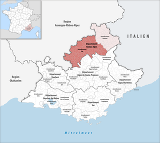
Hautes-Alpes is a department in the Provence-Alpes-Côte d'Azur region of Southeastern France. It is located in the heart of the French Alps, after which it is named. Hautes-Alpes had a population of 141,220 as of 2019, which makes it the third least populated French department. Its prefecture is Gap; its sole subprefecture is Briançon. Its INSEE and postal code is 05.

<span class="mw-page-title-main">Arrondissement of Gap</span> Arrondissement in Provence-Alpes-Côte dAzur, France

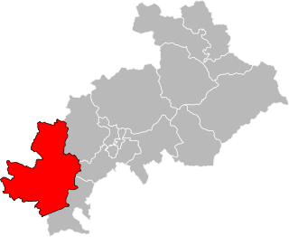
The arrondissement of Gap is an arrondissement of France in the Hautes-Alpes department in the Provence-Alpes-Côte d'Azur region. It has 126 communes. Its population is 105,841 (2016), and its area is 3,410.5 km2 (1,316.8 sq mi).

<span class="mw-page-title-main">Beaumes-de-Venise</span> Commune in Provence-Alpes-Côte dAzur, France

Beaumes-de-Venise is a commune in the Vaucluse department in the Provence-Alpes-Côte d'Azur region in southeastern France.

<span class="mw-page-title-main">La Brillanne</span> Commune in Provence-Alpes-Côte dAzur, France

La Brillanne is a commune in the department of Alpes-de-Haute-Provence in southeastern France.

<span class="mw-page-title-main">La Bâtie-Neuve</span> Commune in Provence-Alpes-Côte dAzur, France

La Bâtie-Neuve is a commune in the Hautes-Alpes department in southeastern France.

<span class="mw-page-title-main">Blieux</span> Commune in Provence-Alpes-Côte dAzur, France

Blieux is a rural commune in the Alpes-de-Haute-Provence department in the Provence-Alpes-Côte d'Azur region in Southeastern France.

<span class="mw-page-title-main">Clamensane</span> Commune in Provence-Alpes-Côte dAzur, France

Clamensane is a commune in the Alpes-de-Haute-Provence department in southeastern France.

<span class="mw-page-title-main">La Rochegiron</span> Commune in Provence-Alpes-Côte dAzur, France

La Rochegiron is a commune in the Alpes-de-Haute-Provence department in southeastern France.

<span class="mw-page-title-main">Le Castellet, Alpes-de-Haute-Provence</span> Commune in Provence-Alpes-Côte dAzur, France

Le Castellet is a rural commune in the Alpes-de-Haute-Provence department in the Provence-Alpes-Côte d'Azur region in Southeastern France. It is located north of Valensole, east of the Valley of the Durance. In 2021 it had a population of 301.

<span class="mw-page-title-main">La Garde, Alpes-de-Haute-Provence</span> Place in Provence-Alpes-Côte dAzur, France

La Garde is a commune in the Alpes-de-Haute-Provence department in southeastern France.

<span class="mw-page-title-main">La Rochette, Alpes-de-Haute-Provence</span> Commune in Provence-Alpes-Côte dAzur, France

La Rochette is a commune in the Alpes-de-Haute-Provence department in southeastern France.

<span class="mw-page-title-main">Le Noyer, Hautes-Alpes</span> Commune in Provence-Alpes-Côte dAzur, France

Le Noyer is a commune in the Hautes-Alpes department in southeastern France. With its neighbouring hamlets of Le Serre, Le Martouret and Le Villard, it lies on the banks of the river Drac, close to the Écrins National Park.

<span class="mw-page-title-main">La Rochette, Hautes-Alpes</span> Commune in Provence-Alpes-Côte dAzur, France

La Rochette is a commune in the Hautes-Alpes department in southeastern France. It is located about 10 km north east of Gap.

<span class="mw-page-title-main">La Beaume</span> Commune in Provence-Alpes-Côte dAzur, France

La Beaume is a commune in the Hautes-Alpes department in southeastern France.

<span class="mw-page-title-main">La Saulce</span> Commune in Provence-Alpes-Côte dAzur, France

La Saulce is a commune in the Hautes-Alpes department in southeastern France.

<span class="mw-page-title-main">La Salle-les-Alpes</span> Commune in Provence-Alpes-Côte dAzur, France

La Salle-les-Alpes is a commune in the Hautes-Alpes department in the Provence-Alpes-Côte d'Azur region in Southeastern France.

<span class="mw-page-title-main">La Roche-des-Arnauds</span> Commune in Provence-Alpes-Côte dAzur, France

La Roche-des-Arnauds is a commune in the Hautes-Alpes department in southeastern France.

<span class="mw-page-title-main">Oze, Hautes-Alpes</span> Commune in Provence-Alpes-Côte dAzur, France

Oze is a commune in the Hautes-Alpes department in southeastern France.

The canton of Aspres-sur-Buëch is a former administrative division in southeastern France. It was disbanded following the French canton reorganisation which came into effect in March 2015. It consisted of 8 communes, which joined the canton of Serres in 2015. It had 1,976 inhabitants (2012).

<span class="mw-page-title-main">Canton of Serres</span> Canton in Provence-Alpes-Côte dAzur, France

The canton of Serres is an administrative division in southeastern France. At the French canton reorganisation which came into effect in March 2015, the canton was expanded from 12 to 41 communes :

References

  1. "Répertoire national des élus: les maires". data.gouv.fr, Plateforme ouverte des données publiques françaises (in French). 2 December 2020.
  2. "Populations légales 2021" (in French). The National Institute of Statistics and Economic Studies. 28 December 2023.
  3. Population en historique depuis 1968, INSEE