La Vida Mineral Springs

Last updated

La Vida Mineral Springs
La Vida (or LaVida) Hot Springs
La Vida Mineral Springs Well
La Vida Hot Soda Springs
Spring at La Vida probably circa 1920.jpg
La Vida c.1920(Edward W. Cochems, UC Irvine Libraries)
La Vida Mineral Springs
Coordinates 33°56′06″N117°47′33″W / 33.935°N 117.7926°W / 33.935; -117.7926
Elevation790 ft (240 m) [1]
Type Thermal
Discharge76 L/min (20 US gal/min) [2]
Temperature43 °C (109 °F) [2]
Depth2,035 ft (620 m) [1]

La Vida Hot Springs were a historically significant natural spring and nearby hot-water well in Carbon Canyon, Chino Hills, Orange County, California, United States.

Contents

Geography

The La Vida springs were located about halfway between Pomona and Anaheim. [2] They are very close to the point where the borders of Los Angeles, Orange, and San Bernardino counties meet, specifically about 1.35 mi (2.17 km) southwest of the Orange County line. [1] The water well was about 150 ft (46 m) north of Carbon Canyon Road, and the bottling plant that existed for a time was adjacent to the well. [1] The closest human settlement is historic Olinda. [1] The La Vida subdivision of the geologic Puente Formation is named for rock layers found in the vicinity of La Vida Mineral Springs. [3]

History

La Vida is the site of two separate water sources, a natural spring or seep known to indigenous people, and a water well drilled in 1893 as part of the exploration of the Brea-Olinda Oil Field. [4] [5] [6]

La Vida Mineral Springs, sometimes called LaVida Hot Springs, was operated as a resort and spa from the 1910s to the 1980s. [7] The resort had swimming pools, a café, and cabins and a motel for visitors. The springs were also the site of LaVida Beverage bottling plant. [8] (La Vida Beverage later moved many operations to Fullerton.) [9]

Major development of the site began with a $150,000 investment in 1924, [10] and with the paving of the Carbon Canyon Road in 1925, which was touted as a "benefit to ranchers". [11] This development might have also been beneficial to bootleggers that were based at La Vida during the Prohibition era. [5] [12] At least one of the buildings on the site had a "Thirties Deco look," and the owners of the beverage company were based in downtown Los Angeles in the early 1930s. [6] [13] [14] Former boxer Archie Rosenbaum had a stake in the place at one time, and La Vida eventually became a popular resort for Southern California's Jewish community in the mid-20th century. [5]

La Vida Mineral Springs and Carbon Canyon Mineral Springs c. 1949 (USGS Yorba Linda quandrangle map) Springs in Carbon Canyon excerpt from USGS 1 to 24000-scale Quadrangle for Yorba Linda, CA 1949.jpg
La Vida Mineral Springs and Carbon Canyon Mineral Springs c.1949(USGS Yorba Linda quandrangle map)

The site was bought and operated by a Japanese-American family in the 1970s and 1980s but was closed following a 1988 fire. [5] Only a restaurant survived, which became a popular biker bar. [12] The 2008 Freeway Complex Fire destroyed most of the remaining infrastructure on the site except the concrete water tank. [15]

Water profile

The well produced 25,000 to 30,000 gallons a day. [6] Despite the common name "hot springs," La Vida is classified by geothermal energy researchers as a warm spring; the water temperature was 43 °C (109 °F). [2]

See also

Related Research Articles

<span class="mw-page-title-main">Brea, California</span> City in California, United States

Brea is a city in northern Orange County, California. The population as of the 2010 census was 39,282. It is 33 miles (53 km) southeast of Los Angeles. Brea is part of the Los Angeles metropolitan area.

<span class="mw-page-title-main">Scovern Hot Springs</span> Former settlement in California, United States

Scovern Hot Springs is a thermal spring system, and former settlement in the Kern River Valley of the Southern Sierra Nevada, in Kern County, California.

The Olinda Landfill is a landfill situated in Orange County, California, west of the northern portion of Chino Hills State Park in Carbon Canyon in Olinda neighborhood of Brea City.

<span class="mw-page-title-main">Seminole Hot Springs, California</span> Unincorporated community in California, United States

Seminole Hot Springs is an unincorporated community in Los Angeles County, California, United States. Seminole Hot Springs is located in the Santa Monica Mountains near Cornell, 3.6 miles (5.8 km) south-southeast of Agoura Hills at an elevation of 932 feet (284 m).

<span class="mw-page-title-main">Bimini Baths</span> Los Angeles natatorium (1903–1951)

Bimini Baths was a geothermal mineral water public bathhouse and plunge in what is now Koreatown, Los Angeles, California, US. It was situated just west of downtown, near Third Street and Vermont Avenue. Bimini Baths contained a natatorium, swimming pools, swimming plunge, Turkish baths, a medical treatment department, and bottling works.

<span class="mw-page-title-main">Wheeler Springs, California</span> Unincorporated community in California, United States

Wheeler Springs is an unincorporated community that grew around a set of sulphurated hot springs in Ventura County, California. It is located 6 miles north of the Ojai Valley, within Los Padres National Forest. It is named for Wheeler Blumberg, who founded the town in 1891, and the many natural hot springs.

<span class="mw-page-title-main">Tuscan Springs</span> Geothermal feature in California

Tuscan Springs are a group of springs in the U.S. state of California. Tuscan Springs was named for the fact its borax-impregnated waters were chemically similar to the springs of Tuscany, in Italy.

<span class="mw-page-title-main">Sespe Hot Springs</span> Thermal springs

Sespe Hot Springs are a system of thermal springs and seeps that form a hot spring creek in the mountains near the Sespe Condor Sanctuary near Ojai, California.

<span class="mw-page-title-main">Encino Hot Springs</span> Thermal springs

Encino Hot Springs are historic thermal springs located at the site of Siutcanga village, a settlement of the Tongva-Kizh people of the area now known as Southern California. It was used by several tribes of Indigenous peoples for thousands of years. Later, after settlement, the artesian springs were used as a water source for Rancho Los Encinos in what is now the San Fernando Valley region of Los Angeles County, California. In the 1880s it was a rest stop on the Butterfield Stagecoach route. The springs are located in the modern-day Los Encinos State Historic Park.

<span class="mw-page-title-main">San Juan Hot Springs</span> Historic geothermal site in California

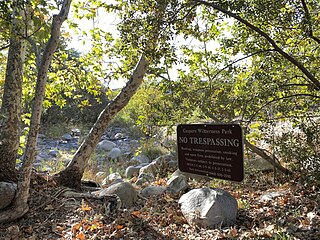
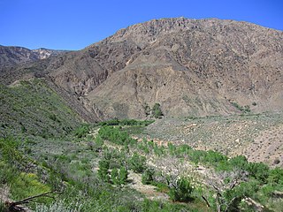
San Juan Hot Springs, also San Juan Capistrano Hot Springs, is a geothermal area in what is now Ronald W. Caspers Wilderness Park, near Cleveland National Forest, in Orange County, California in the United States. The springs were used by the Indigenous peoples of the region, and were an integral part of the dominion of Misíon San Juan Capistrano. They were later developed and used, on and off for a hundred years, as a resort area of post-settlement Southern California. The 52 springs were designated Orange County Historic Landmark No. 38 in 1989.

<span class="mw-page-title-main">Soboba Hot Springs</span> Geothermal site in California

Soboba Hot Springs are a historic hot springs and resort in Riverside County, California, United States. The springs issued from the side of a steep ravine "with narrow, precipitous sides, and the rock exposed is largely a crushed gneiss...the thermal character of the springs is due to crushing and slipping of the rocks". The Soboba Hot Springs resort was adjacent to the reservation of the Soboba Band of Luiseño Indians. Soboba means hot water in the Luiseño language.

<span class="mw-page-title-main">Eden Hot Springs</span> Geothermal site in California

Eden Hot Springs was a historic hot springs and resort in Riverside County, California, United States.

<span class="mw-page-title-main">Gaviota Hot Springs</span> Geothermal site in California

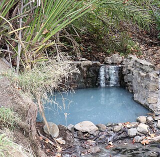
Gaviota Hot Springs is a geothermal feature in Santa Barbara County, California, United States. The two pools are accessible from the Gaviota Peak trail in Gaviota State Park. Gaviota Hot Springs is sometimes called Las Cruces Hot Springs or Sulphur Springs. The hot springs lie within the Hot Springs Creek watershed, near the junction of U.S. Route 101 and California State Route 1.

<span class="mw-page-title-main">Veronica Springs</span> Historic mineral spring, California

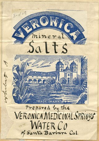
Veronica Springs, also Veronica Medicinal Springs, was a cluster of natural springs along Arroyo Burro creek in Santa Barbara County, California, United States. Veronica spring water was not a therapeutic spa water or a table water but a medicinal mineral water with high magnesium levels. The waters had a yellowish tinge and a strongly purgative-laxative effect, and beginning around 1887, the water was bottled and sold as a health tonic. Veronica Water peaked as a brand in the 1910s. The springs were capped off in 1962.

<span class="mw-page-title-main">Alvarado Hot Springs</span> Defunct water source in California

Alvarado Hot Springs was a 20th-century geothermal well in Los Angeles County, California, United States. A bathhouse was built next to the water and a therapeutic spa was operated on the site for several decades.

<span class="mw-page-title-main">Tolenas Springs</span> Water source in California

Tolenas Springs is a group of natural carbonated-water soda springs in the hills of Solano County, California, United States. The springs emerge from a formation of travertine that has been intermittently quarried for building material. The springs are located on private property and are closed to the public.

<span class="mw-page-title-main">Console Springs</span> Body of water, California

Console Springs was a natural spring in Reche Canyon, Riverside County, California, United States. The waters were bottled for sale in the early 20th century.

<span class="mw-page-title-main">Delonegha Hot Springs</span> Geothermal site in California

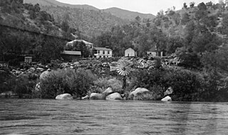
Delonegha Hot Springs are located in Kern County, California, United States, northeast of the city of Bakersfield and southeast of Glennville. Delonegha is one of several hot springs adjacent to the Kern River and State Route 178. The springs lie within the boundaries of Sequoia National Forest, "100 yd (91 m) down a steep dirt trail" from the highway. Except for a brief period in the first years of the 20th century when there was a small resort at the site, the Delonegha springs have remained largely undeveloped.

<span class="mw-page-title-main">Democrat Hot Springs</span> Geothermal site in California

Democrat Hot Springs, named for the Democratic political party, is a geothermally heated spring located 17 miles (27 km) northeast of Bakersfield, California, United States, on the south bank of the Kern River and on the north side of California State Route 178.

<span class="mw-page-title-main">Ontario Hot Springs</span> Geothermal site in California

Ontario Hot Springs is a hot-water well in southern San Luis Obispo County, California, United States. The geothermally heated water from the well is the central feature of a resort called Avila Hot Springs near Avila Beach.

References

  1. 1 2 3 4 5 South Coastal Basin Irrigation Report (1933), p. 44.
  2. 1 2 3 4 Higgins, Therberge & Ikelman (1980).
  3. Durham & Yerkes (1964), p. B12.
  4. Berkstresser (1968), p. A-9.
  5. 1 2 3 4 Schrader, Esther (July 22, 1997). "Hoping Hot Springs Are Hot Spot Again". Los Angeles Times. Retrieved 2024-06-14.
  6. 1 2 3 Sammon (1986), p. 144.
  7. Spitzzeri, Paul (October 17, 2020). "In Hot Water in Carbon Canyon". Champion Newspapers. Retrieved 2024-06-14.
  8. Falk, Tracy Smith (February 9, 2024). "La Vida Mineral Springs of Carbon Canyon – Orange County Historical Society" . Retrieved 2024-06-14.
  9. "The Historical volume and reference works v.2". HathiTrust. hdl:2027/uc1.31210011866041 . Retrieved 2024-06-14.
  10. "Business". Rio Vista Banner. January 25, 1924. p. 5. Retrieved 2024-06-14.
  11. "Paving Canyon Road is Indorsed". The Bulletin. June 6, 1925. p. 8. Retrieved 2024-06-14.
  12. 1 2 Orange County. Arcadia Publishing. 2005. p. 34. ISBN   978-0-7385-3054-3.
  13. "Bulletin no.107 1932". HathiTrust. hdl:2027/uc1.31210017404276 . Retrieved 2024-06-14.
  14. "California mineral production and directory of mineral producers for 1932 / by Henry H. Symons no.109 1933". HathiTrust. hdl:2027/osu.32435026407494 . Retrieved 2024-06-14.
  15. Prs (December 31, 2014). "Carbon Canyon Chronicle: La Vida Mineral Springs Tank: Vandalism or Deterioration?". Carbon Canyon Chronicle. Retrieved 2024-06-14.

Sources