Lajas, Lajas, Puerto Rico

Last updated
Lajas
Barrio
Lajas, Lajas, Puerto Rico locator map.png
Location of Lajas within the municipality of Lajas shown in red
Caribbean location map.svg
Red pog.svg
Lajas
Location of Puerto Rico
Coordinates: 18°03′27″N67°02′58″W / 18.05742°N 67.04952°W / 18.05742; -67.04952 [1]
Commonwealth Flag of Puerto Rico.svg  Puerto Rico
Municipality Flag of Lajas (PR).svg Lajas
Area
[1]
  Total1.6 sq mi (4 km2)
  Land1.6 sq mi (4 km2)
  Water0 sq mi (0 km2)
Elevation
[2]
217 ft (66 m)
Population
 (2010)
  Total2,694
  Density1,683.8/sq mi (650.1/km2)
 Source: 2010 Census
Time zone UTC−4 (AST)

Lajas is a barrio in the municipality of Lajas, Puerto Rico. Its population in 2010 was 2,694. [3] [4] [5]

Historical population
CensusPop.Note
1940 900
1950 2,544182.7%
1960 2,369−6.9%
1970 0−100.0%
1980 2,095
1990 2,1663.4%
2000 2,3317.6%
2010 2,69415.6%
U.S. Decennial Census
1940-1950 [6] 1980-2000 [7] 2010 [8]

See also

Related Research Articles

<span class="mw-page-title-main">Monacillo Urbano, San Juan, Puerto Rico</span> Barrio of San Juan, Puerto Rico

Monacillo Urbano is one of 18 barrios in the municipality of San Juan, Puerto Rico. The barrio was originally part of Monacillo. In 2010, it had a population of 22,342 living in a land area of 3.23 square miles (8.68 km2). Monacillo Urbano is surrounded by Gobernador Piñero barrio to the north, El Cinco barrio to the east, Monacillo barrio to the south, and the municipality of Guaynabo to the west.

<span class="mw-page-title-main">Oriente, San Juan, Puerto Rico</span> Barrio of Puerto Rico

Oriente is one of the 18 barrios of the municipality of San Juan, Puerto Rico. It is composed of 3 subbarrios: Borinquen, López Sicardó, and San José. Before 1951, it was a barrio of the former municipality of Rio Piedras. In 2010, it had a population of 31,374. It is surrounded by the barrios of Sabana Llana Norte to the east, Sabana Llana Sur to the south, Hato Rey Central and Hato Rey Norte to the west, and Santurce barrio and the San Jose Lagoon to the north.

<span class="mw-page-title-main">Río Lajas, Dorado, Puerto Rico</span> Barrio of Puerto Rico

Río Lajas is a barrio in the municipality of Dorado, Puerto Rico. Its population in 2010 was 2,559.

<span class="mw-page-title-main">Lajas Arriba</span> Barrio of Lajas, Puerto Rico

Lajas Arriba is a barrio in the municipality of Lajas, Puerto Rico. Its population in 2010 was 2,456.

<span class="mw-page-title-main">Sabana Yeguas</span> Barrio of Lajas, Puerto Rico

Sabana Yeguas is a barrio in the municipality of Lajas, Puerto Rico. Its population in 2010 was 2,082.

<span class="mw-page-title-main">Buena Vista, Hatillo, Puerto Rico</span> Barrio of Puerto Rico

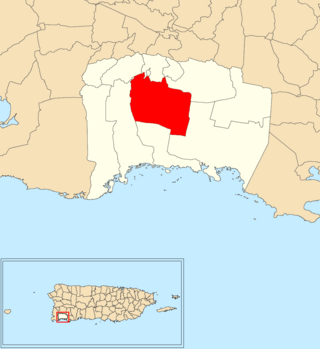
Buena Vista is a rural barrio in the municipality of Hatillo, Puerto Rico. Its population in 2010 was 2,490.

<span class="mw-page-title-main">Llanos, Lajas, Puerto Rico</span> Barrio of Puerto Rico

Llanos is a barrio in the municipality of Lajas, Puerto Rico. Its population in 2010 was 675.

<span class="mw-page-title-main">Campo Alegre, Hatillo, Puerto Rico</span> Barrio of Puerto Rico

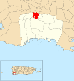
Campo Alegre is a rural barrio in the municipality of Hatillo, Puerto Rico. Its population in 2010 was 5,210.

<span class="mw-page-title-main">Jauca</span> Barrio of Jayuya, Puerto Rico

Jauca is a barrio in the municipality of Jayuya, Puerto Rico. Its population in 2010 was 116. In 1948, Jauca was established from part of what was Jayuya Arriba .

<span class="mw-page-title-main">Pica, Jayuya, Puerto Rico</span> Barrio of Puerto Rico

Pica is a barrio in the municipality of Jayuya, Puerto Rico. Its population in 2010 was 153. In 1948, Pica was established from part of what was Jayuya Arriba .

<span class="mw-page-title-main">Zamas, Jayuya, Puerto Rico</span> Barrio of Puerto Rico

Zamas is a barrio in the municipality of Jayuya, Puerto Rico. Its population in 2010 was 499.

<span class="mw-page-title-main">Carenero</span> Barrio of Guánica, Puerto Rico

Carenero is a barrio in the municipality of Guánica, Puerto Rico. Its population in 2010 was 2,670.

<span class="mw-page-title-main">Santa Rosa, Lajas, Puerto Rico</span> Barrio of Puerto Rico

Santa Rosa is a barrio in the municipality of Lajas, Puerto Rico. Its population in 2010 was 1,603.

<span class="mw-page-title-main">Candelaria, Lajas, Puerto Rico</span> Barrio of Puerto Rico

Candelaria is a barrio in the municipality of Lajas, Puerto Rico. Its population in 2010 was 3,599.

<span class="mw-page-title-main">Palmarejo, Lajas, Puerto Rico</span> Barrio of Puerto Rico

Palmarejo is a barrio in the municipality of Lajas, Puerto Rico. Its population in 2010 was 3,750.

<span class="mw-page-title-main">Plata, Lajas, Puerto Rico</span> Barrio of Puerto Rico

Plata is a barrio in the municipality of Lajas, Puerto Rico. Its population in 2010 was 2,620.

<span class="mw-page-title-main">Río Lajas, Toa Alta, Puerto Rico</span> Barrio of Puerto Rico

Río Lajas is a barrio in the municipality of Toa Alta, Puerto Rico. Its population in 2010 was 2,566.

<span class="mw-page-title-main">París, Lajas, Puerto Rico</span> Barrio of Puerto Rico

París is a barrio in the municipality of Lajas, Puerto Rico. Its population in 2010 was 968.

<span class="mw-page-title-main">Costa, Lajas, Puerto Rico</span> Barrio of Puerto Rico

Costa is a barrio in the municipality of Lajas, Puerto Rico. Its population in 2010 was 1,628.

<span class="mw-page-title-main">St. Just, Trujillo Alto, Puerto Rico</span> Barrio of Puerto Rico

St. Just is a barrio in the municipality of Trujillo Alto, Puerto Rico. A newer barrio, its population is counted starting with the 2000 Census, and in 2010 was 14,635.

References

  1. 1 2 "US Gazetteer 2019". US Census. US Government.
  2. U.S. Geological Survey Geographic Names Information System: Lajas barrio
  3. Picó, Rafael; Buitrago de Santiago, Zayda; Berrios, Hector H. Nueva geografía de Puerto Rico: física, económica, y social, por Rafael Picó. Con la colaboración de Zayda Buitrago de Santiago y Héctor H. Berrios. San Juan Editorial Universitaria, Universidad de Puerto Rico,1969.
  4. Gwillim Law (20 May 2015). Administrative Subdivisions of Countries: A Comprehensive World Reference, 1900 through 1998. McFarland. p. 300. ISBN   978-1-4766-0447-3 . Retrieved 25 December 2018.
  5. Puerto Rico: 2010 Population and Housing Unit Counts.pdf (PDF). U.S. Dept. of Commerce, Economics and Statistics Administration, U.S. Census Bureau. 2010.
  6. "Table 4-Area and Population of Municipalities Urban and Rural: 1930 to 1950" (PDF). United States Census Bureau. Archived (PDF) from the original on August 30, 2015. Retrieved September 21, 2014.
  7. "Table 2 Population and Housing Units: 1960 to 2000" (PDF). United States Census Bureau. Archived (PDF) from the original on July 24, 2017. Retrieved September 21, 2017.
  8. Puerto Rico: 2010 Population and Housing Unit Counts.pdf (PDF). U.S. Dept. of Commerce Economics and Statistics Administration U.S. Census Bureau. 2010. Archived (PDF) from the original on 2017-02-20. Retrieved 2019-08-02.