Lake Gregory (Western Australia)

Last updated

Lake Gregory
(Paraku)
Gregory lake.jpg
Lake Gregory from space, September 1993. The main body of the lake appears bluish-turquoise in the center of the picture. The multi-braided channels (upper right) that feed water into Lake Gregory from the northeast are part of the Sturt Creek drainage system. There appears to be an excess of standing water in the channels (muddy-looking, yellowish) north and west of the main part of the lake. The surrounding landscape consists of grasslands with numerous sand ridges (thin, dark, parallel lines on the lower left side of the image).
Australia Western Australia relief location map.png
Red pog.svg
Lake Gregory
(Paraku)
Location in Western Australia
Location Kimberley, Western Australia
Coordinates 20°12′S127°27′E / 20.200°S 127.450°E / -20.200; 127.450
Type Brackish water
Native nameParaku (Walmajarri)
Primary inflows Sturt Creek
Primary outflows internal drainage
Basin  countriesAustralia
References [1]
Lake Gregory (Western Australia)

Lake Gregory, or Paraku in the Walmajarri language, [2] is a permanent brackish lake located in the Kimberley region of Western Australia, situated between the Great Sandy Desert and the Tanami Desert. Following monsoonal rains it may hold fresh water, but becomes more saline after a number of dry years. [3]

Contents

Location

The lake is situated approximately 220 kilometres (137 mi) south of Halls Creek near where the Tanami Desert meets the Great Sandy Desert. The nearest town is the Mulan Community located 8 kilometres (5 mi) to the east of the lake shore. The boundaries of two pastoral leases also encompass parts of the lake; Billiluna Station to the north and Lake Gregory Station to the south. [3]

Lake Gregory is situated on the edge of Mulan Aboriginal Community, home to the Walmajarri people. It is a traditional site to the people, containing several culturally significant sites. The Paraku Indigenous Protected Area works with traditional owners and rangers to monitor and maintain the lake and its surroundings. [4]

Description

The lake is about 200 metres (656 ft) above sea level. The system includes an area of about 400 square kilometres (154 sq mi) that is subject to regular flooding within a much larger, approximately 5,000 square kilometres (1,931 sq mi), paleolake bed. [3]

The depth of the lake can vary from 1 to 10 metres (3 to 33 ft). [5]

It lies at the far southwest extremity of the Tanami subregion of the Tanami Interim Biogeographic Regionalisation of Australia region. The Tanami subregion is composed mainly red Quaternary sandplains overlying Permian and Proterozoic strata that are exposed as hills and ranges around the area. Alluvial and lacustrine calcareous deposits occur throughout the subregion. In the north they are associated with Sturt Creek drainage and further south as part of the lake bed. [3]

The lake lies in the northeast Canning Basin, within the Gregory sub-basin and is underlain by almost 16 kilometres (10 mi) of sedimentary rocks, ranging in age from Ordovician to mid-Triassic. The rocks are covered by alluvium and lacustrine sediments to a maximum thickness of approximately 30 metres (98 ft). The bed of the lake is clay with the formation of some salt and gypsum pans. [3]

The Lake Gregory System consists of several interconnected waterbodies and is fed primarily by Sturt Creek. The creek has a catchment area of approximately 65,000 square kilometres (25,097 sq mi) and flows north to south as a single channel until a short distance south of Halls Creek. After this, it breaks into an anastomosing channel system forming a series of shallow interconnected basins. The western tributary of Sturt Creek feeds into Rillya, Kurdu, Yuenbi and Bulbi Lakes. The eastern tributary discharges through Leira waterhole into Mulan Lake which is the largest lake and can remain full for several years following stream flow events. [3]

History

The lake was once part of a inland sea some ten times larger than the current lake around 300,000 years ago. It is now part of a larger system of freshwater and salt water lakes fed by Sturt Creek. [6] The waters of the lake are dependent on water coming in from the creek and from monsoonal rains. Water loss from the lake is due to evaporation and infiltration into the paleochannel. There is no outflow from the lake. [5]

The lake appeared as Gregory's Salt Sea on Alfred Canning's map of the area when he was surveying the Canning Stock Route. It was named to honour the explorer Augustus Gregory who traversed the area in 1856. [6]

The country around the lake and river systems provides an abundant source of plant and animal life that attracted the attention of the pastoral industry in the early 1900s. The Canning Stock Route, established in 1910 from Halls Creek south to the rail-head at Wiluna to drove cattle from the east Kimberley, runs down the western margin of the lake system. [6]

Lake Gregory Station covers 270,000 hectares (667,185 acres) and has a potential carrying capacity of 6,720 cattle. It had not operated as a cattle station from the 1980s to 2016 when it was acquired by the Aboriginal Land Trust. It has been sub-leased to the Yougawalla Pastoral Company. [7] [8]

In 2001 the High Court of Australia formally recognised the Walmajarri peoples as the traditional owners of the area and awarded them native title over the land. A handover ceremony was conducted on the shores of the lake. [9]

Stone artefacts in situ in sediments recovered from an archaeological dig in 2008 at the Parnkupirti site at Lake Gregory, give optically stimulated luminescence age determinations of at least 37,000 years, making Lake Gregory among the oldest-known inhabited sites in Australia. [10]

Flora

The sandplains around the lake support mixed shrub steppes of Hakea species, desert bloodwoods, a variety of Acacia and Grevillea species over soft spinifex hummock grasslands. Wattle scrub over soft spinifex hummock grass communities occur on the ranges of the area. The drainage lines of the creeks support ribbon and Flinders grasses and other short grasslands, often as savannas with stands of River red gums. [3]

Birds

A pair of brolgas amongst other waterbirds in the Northern Territory Brolga2.jpg
A pair of brolgas amongst other waterbirds in the Northern Territory

The lake serves as a major migratory stop-over area for a variety of shorebirds. It also provides a major breeding habitat of several species of water birds, including cormorants and terns. It has been identified by BirdLife International as an Important Bird Area (IBA) because it supports over 1% of the world populations of hardheads, grey teals, pink-eared ducks, little black cormorants, brolgas, sharp-tailed sandpipers. It sometimes supports similarly important numbers of magpie geese, Pacific black ducks, freckled ducks and Oriental plovers, as well as providing habitat for Australian bustards. [11]

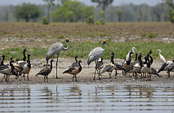
The lake regularly supports over 100,000 water birds, more than any other inland fresh water lake in Australia. In 1988 more than half a million water birds were recorded at the lake representing at least 67 different species. [5]

See also

Related Research Articles

<span class="mw-page-title-main">Great Sandy Desert</span> Desert in Northern Western Australia

The Great Sandy Desert is an interim Australian bioregion, located in the northeast of Western Australia straddling the Pilbara and southern Kimberley regions and extending east into the Northern Territory. It is the second largest desert in Australia after the Great Victoria Desert and encompasses an area of 284,993 square kilometres (110,036 sq mi). The Gibson Desert lies to the south and the Tanami Desert lies to the east of the Great Sandy Desert.

The Tjurabalan (Jura-palan) is a nomadic desert tribe from the edge of the Tanami Desert near Sturt Creek and The Paraku Lake system, Lake Gregory in the Kimberley region of Western Australia.

<span class="mw-page-title-main">Fitzroy River (Western Australia)</span> River in Western Australia

The Fitzroy River, also known as Martuwarra, is located in the West Kimberley region of Western Australia. It has 20 tributaries and its catchment occupies an area of 93,829 square kilometres (36,228 sq mi), within the Canning Basin and the Timor Sea drainage division.

<span class="mw-page-title-main">Tanami Road</span> Road in the Northern Territory and Western Australia

The Tanami Road, also known as the Tanami Track, Tanami Highway, and the McGuire Track, is a road in Australia that runs between the Stuart Highway in the Northern Territory and the Great Northern Highway in Western Australia. It is also known as State Route 5 in the Northern Territory. Its southern junction is 19 kilometres (12 mi) north of Alice Springs and the northern junction is 17 kilometres (11 mi) south-west of Halls Creek. It follows a cattle droving route northwest from the MacDonnell Ranges area of central Australia to Halls Creek in the Kimberley.

<span class="mw-page-title-main">Deserts of Australia</span> Deserts in Australia

The deserts of Australia or the Australian deserts cover about 2,700,000 km2 (1,000,000 sq mi), or 18% of the Australian mainland, but about 35% of the Australian continent receives so little rain, it is practically desert. Collectively known as the Great Australian desert, they are primarily distributed throughout the Western Plateau and interior lowlands of the country, covering areas from South West Queensland, Far West region of New South Wales, Sunraysia in Victoria and Spencer Gulf in South Australia to the Barkly Tableland in Northern Territory and the Kimberley region in Western Australia.

Newhaven Wildlife Sanctuary, once a cattle station known as Newhaven Station is an Australian nature reserve. It lies around 300–400 kilometres (186–249 mi) north-west of Alice Springs in the Northern Territory of Australia. It is jointly operated by Birds Australia and the Australian Wildlife Conservancy.

<span class="mw-page-title-main">Balgo, Western Australia</span> Community in Western Australia

Balgo, previously Balgo Hills and Balgo Mission, is a community in Western Australia that is linked with both the Great Sandy Desert and the Tanami Desert. The community is in the Shire of Halls Creek, off the Tanami Road, and was established by German missionaries in 1939. In the 2021 census Balgo's population numbered 430.

<span class="mw-page-title-main">Shire of Halls Creek</span> Shire in the Kimberley region of Western Australia

The Shire of Halls Creek is one of the four local government areas in the Kimberley region of northern Western Australia, covering an area of 143,030 square kilometres (55,224 sq mi), most of which is sparsely populated. The Shire's seat of government is the town of Halls Creek. Many Aboriginal communities are located within the shire.

<span class="mw-page-title-main">Geography of Western Australia</span>

Western Australia occupies nearly one third of the Australian continent. Due to the size and the isolation of the state, considerable emphasis has been made of these features; it is the second largest administrative territory in the world, after Yakutia in Russia, despite the fact that Australia is only the sixth largest country in the world by area, and no other regional administrative jurisdiction in the world occupies such a high percentage of a continental land mass. It is also the only first level administrative subdivision to occupy the entire continental coastline in one cardinal direction.

Mulan is a small Aboriginal community in Western Australia's east Kimberley. The community is in the Shire of Halls Creek, 44 km to the southwest of Balgo and about 10 km east of Lake Gregory. At the 2006 census, Mulan had a population of 114.

Tanami Downs is an Indigenous Australian-owned cattle station in the Northern Territory of Australia.

Ruby Plains Station is a pastoral lease and cattle station located about 41 kilometres (25 mi) south of Halls Creek in the Kimberley region of Western Australia. It is situated along the Tanami Track and is used as a stopping place along the Canning Stock Route.

Supplejack Downs, also known as Suplejack Downs, is a pastoral lease operating as a cattle station in the Northern Territory of Australia.

<span class="mw-page-title-main">Moola Bulla</span> Pastoral lease in Western Australia

<i>Acacia maconochieana</i> Species of legume

Acacia maconochieana, also known as Mullan wattle, is a shrub or tree of the genus Acacia and the subgenus Plurinerves that is endemic to an arid area of central Australia.

<span class="mw-page-title-main">Strzelecki Creek</span> River in South Australia, Australia

The Strzelecki Creek, part of the Lake Eyre basin, is an ephemeral watercourse located in the Australian state of South Australia.

<span class="mw-page-title-main">Billiluna Station</span> Pastoral lease in Western Australia

Billiluna Station is a pastoral lease that operates as a cattle station in Western Australia.

The Ngurrara and Ngururrpa are overlapping groupings of Aboriginal Australian peoples of the Great Sandy Desert, in the central Pilbara and southern Kimberley regions of Western Australia. Both groups are represented by various Aboriginal corporations which look after their native title interests.

The Djaru people are an Aboriginal Australian people of the southern Kimberley region of Western Australia.

Lake Mackay is a locality in the Northern Territory of Australia located on the territory’s south-west adjoining the border with the state of Western Australia about 1,202 kilometres (747 mi) south of the territory capital of Darwin and about 458 kilometres (285 mi) west of the municipal seat in Alice Springs.

References

  1. "Lake Gregory". Gazetteer of Australia online. Geoscience Australia, Australian Government.
  2. Monroe, M. H. (20 November 2013). "Aboriginal Occupation - Populating the Continent - Desert". Australia: The Land Where Time Began. Retrieved 23 August 2015.
  3. 1 2 3 4 5 6 7 Daniel, Glen; Kern, Stephen; Pinder, Adrian; Nowicki, Anna (August 2009). "Resource Condition Report for a Significant Western Australian Wetland" (PDF). Bentley, WA: Department of Environment and Conservation. Retrieved 5 May 2020.
  4. Shain, Kathryn (22 December 2004). "Paraku Indigenous Protected Area". Agreements, treaties and negotiated settlements project. Indigenous Studies Program, The University of Melbourne . Retrieved 23 August 2015.
  5. 1 2 3 "Lake Gregory - Paruku". WaNowandThen. Retrieved 4 March 2017.
  6. 1 2 3 "Paruka - Lake Gregory - Gregory's Salt Sea". Mira Canning Stock Route Archive Project. 2010. Retrieved 4 March 2017.
  7. Brammer, Jenne (31 July 2018). "Historic deal to sublease Kimberley station". West Australian. Perth, WA. Retrieved 5 May 2020.
  8. Liz Wells (30 November 2016). "Aboriginal Land Trust seeks operator with a difference for Kimberley's Lake Gregory". Beef Central. Nascon Media Pty Ltd. Retrieved 6 March 2017.
  9. "Paruku (Lake Gregory)". Australia's North West. Retrieved 4 March 2017.
  10. Veth, P.; Smith, M.; Bowler, J.; Fitzsimmons, K.; Williams, A.; Hiscock, P. (2009). "Excavations at Parnkupirti, Lake Gregory, Great Sandy Desert: OSL Ages for Occupation before the Last Glacial Maximum". Australian Archaeology. 69 (1): 1–10. doi:10.1080/03122417.2009.11681896. S2CID   141138103.
  11. "IBA: Lake Gregory/Paraku". Birdata. Birds Australia. Archived from the original on 6 July 2011. Retrieved 26 July 2011.