
The Assiniboine River is a 1,070-kilometre (660 mi) river that runs through the prairies of Western Canada in Saskatchewan and Manitoba. It is a tributary of the Red River. The Assiniboine is a typical meandering river with a single main channel embanked within a flat, shallow valley in some places and a steep valley in others. Its main tributaries are the Qu'Appelle, Souris, and Whitesand Rivers. For early history and exploration see Assiniboine River fur trade.

The Souris River or Mouse River is a river in central North America. Approximately 435 miles (700 km) in length, it drains about 23,600 square miles (61,100 km2) in Canada and the United States.

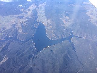
Oroville Dam is an earthfill embankment dam on the Feather River east of the city of Oroville, California, in the Sierra Nevada foothills east of the Sacramento Valley. At 770 feet (235 m) high, it is the tallest dam in the U.S. and serves mainly for water supply, hydroelectricity generation, and flood control. The dam impounds Lake Oroville, the second-largest reservoir in California, capable of storing more than 3.5 million acre-feet (1.1×10^12 US gal; 4.3×10⁹ m3).

A reservoir is an enlarged lake behind a dam, usually built to store fresh water, often doubling for hydroelectric power generation.
Burrinjuck Dam is a heritage-listed major gated concrete-walled gravity hydro-electric dam at Burrinjuck, Yass Valley Shire, New South Wales, Australia. It has three spillways across the Murrumbidgee River located in the South West Slopes region of New South Wales, Australia. The dam's purpose includes flood mitigation, hydro-power, irrigation, water supply and conservation. The impounded reservoir is called Lake Burrinjuck. It was designed by Lawrence Augustus Burton Wade and built from 1907 to 1927 by Lane & Peters, Sydney. It is also known as Barren Jack Dam and Barrenjack. The property was owned by Department of Planning and Infrastructure. It was added to the New South Wales State Heritage Register on 2 April 1999.
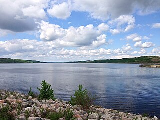
The Shellmouth Reservoir is a man-made reservoir on the Assiniboine River in Manitoba and Saskatchewan, Canada.

Isabella Dam is an embankment dam located in the Kern River Valley, about halfway down the Kern River course, between the towns of Kernville and Lake Isabella in Kern County, California.

The North Saskatchewan River is a glacier-fed river that flows from the Canadian Rockies continental divide east to central Saskatchewan, where it joins with the South Saskatchewan River to make up the Saskatchewan River. Its water flows eventually into the Hudson Bay.

The Grant Devine Dam, formerly Alameda Dam, is an embankment dam located in the Canadian province near Alameda and Oxbow. It was constructed in 1994 to control flows on Moose Mountain Creek and Souris River. It provides flood protection and irrigation for this area of Saskatchewan, along with protection for Minot, North Dakota. The Grant Devine Reservoir provides opportunities for recreational use such as boating and fishing. At the full supply level of 562 metres (1,844 ft), the reservoir holds 105,000,000 m3 (3.7×10⁹ cu ft) of water. The project is owned and operated by the Saskatchewan Water Security Agency (formerly Saskatchewan Watershed Authority).

Lake Qaraoun is an artificial lake or reservoir located in the southern region of the Beqaa Valley, Lebanon. It was created near Qaraoun village in 1959 by building a 61 m-high (200 ft) concrete-faced rockfill dam in the middle reaches of the Litani River. The reservoir has been used for hydropower generation, domestic water supply, and for irrigation of 27,500 ha.
The Fairbairn Dam is an earth-filled embankment dam across the Nogoa River, located southwest of Emerald in Central Queensland, Australia. Constructed in 1972 for the primary purpose of irrigation, the impoundment created by the dam serves as one of the major potable water supplies for the region and assists with some flood mitigation.

The Dahla Dam, also known as Arghandab Dam and Kasa, is located in the Shah Wali Kot District of Kandahar Province in Afghanistan, approximately 40 km (25 mi) northeast of the provincial capital Kandahar. Its name derives from Dahla, which is the historical name of the area where the dam was built. It is the second largest dam in Afghanistan after the Kajaki Dam in neighboring Helmand Province. In 2019, the Afghan government planned to spend $450 million in upgrading the dam. The project includes raising the dam's walls by around 13 meters so the reservoir could hold nearly a billion cubic meters of fresh water and installing three turbines to produce 22 megawatts (MW) of electricity.

The Upper Wardha Dam is an earthfill straight gravity dam across the Wardha River, a tributary of the Godavari River, near Simbhora village in Morshi taluk in Amravati district in the Indian state of Maharashtra. The dam provides multipurpose benefits of irrigation, drinking water supply, flood control and hydropower generation.

Idamalayar Dam is a multipurpose concrete gravity dam located at Ennakkal between Ayyampuzha and Bhoothathankettu in Ernakulam district of Kerala on the Idamalayar, a tributary of the Periyar River in Kerala, South India. The dam however extends east as far as Malakkappara. Completed in 1985, with a length of 373 metres (1,224 ft) and a height of 102.8 metres (337 ft), the dam created a multipurpose reservoir covering 28.3 km2 (10.9 sq mi) in the scenic hills of the Anamalais.

The Bhadra Dam or Lakkavalli Dam, which has created the Bhadra Reservoir, is located on the Bhadra River a tributary of Tungabhadra River. Bhadra Dam is located in the border of Bhadravathi and Tarikere, in the western part of Karnataka in India. The benefits derived from the reservoir storage are irrigation with gross irrigation potential of 162,818 hectares, hydro power generation of 39.2 MW, drinking water supply and industrial use. The dam commissioned in 1965 is a composite earth cum masonry structure of 59.13 metres (194.0 ft) height with length of 1,708 metres (5,604 ft) at the crest level, which submerges a land area of 11,250.88 hectares.

Zengwen Dam, also spelled Tsengwen Dam, is a major earthen dam in Dapu Township, Chiayi County, Taiwan on the Zengwen River. It is the third tallest dam in Taiwan, and forms Zengwen Reservoir (曾文水庫), the biggest reservoir in Taiwan by volume. The dam stores water for irrigation of the Chianan Plain, Taiwan's most productive agricultural region, and provides flood control along the Zengwen River which flows through Tainan City. The dam supports a 50 megawatt hydroelectric power station.

McDonald Lake, also known as Rafferty Reservoir, is a reservoir in the south-eastern part of the Canadian province of Saskatchewan. It was created when the Rafferty Dam was built on the Souris River in 1994. Before the dam was built that flooded the Souris Valley, McDonald Lake was a small lake and marsh on the valley floor adjacent to the Souris River.

In February 2017, heavy rainfall damaged Oroville Dam's main and emergency spillways, prompting the evacuation of more than 180,000 people living downstream along the Feather River and the relocation of a fish hatchery.
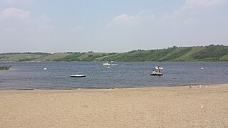
Moosomin Lake, also known as Moosomin Reservoir, is a man-made lake in south-eastern part of the Canadian province of Saskatchewan. Created by the damming of Pipestone Creek in 1954, Moosomin Lake is located about 10 kilometres (6.2 mi) south of the town of Moosomin and is in the Souris River watershed. The reservoir's uses include irrigation, water supply, and recreation. Moosomin Lake Regional Park is on lake's western shore.
Reid Lake, also known as Duncairn Reservoir, is a man-made reservoir in the Canadian Province of Saskatchewan. Reid Lake was formed with the construction of the Duncairn Dam in a glacial meltwater channel along the course of Swift Current Creek in 1942. The reservoir was originally built to supply water for the city of Swift Current, for irrigation projects, and to regulate Swift Current Creek levels downstream. The entire lake is part of the Duncairn Reservoir Migratory Bird Sanctuary.


