Lakeshore Road

Last updated
Lakeshore Road
MissyLakeshoreSign.png
LakeshoreInMississauga.png
Lakeshore Road within Mississauga
Maintained byCity of Burlington
Town of Oakville
City of Mississauga
Length38.5 km (23.9 mi) [1]
Location Burlington, Mississauga, Oakville
West endOntario QEW crown.svg  Queen Elizabeth Way / Eastport Drive in Burlington
Major
junctions
East end MississaugaToronto boundary (continues as Lake Shore Boulevard)
Nearby arterial roads
  Queen Elizabeth Way
Lakeshore Road
N/A
 

Lakeshore Road (originally Lake Shore Road) is a historic roadway in the Canadian province of Ontario, running through the city of Burlington and the town of Oakville in Halton Region, as well as the city of Mississauga in Peel Region. As its name implies, the road closely follows the shoreline of Lake Ontario, although the lake itself is not visible from the road in most areas. Lakeshore Road was once a key section of the historic Highway 2 (as well as a short section of Highway 20), which traversed the province, but has since been downloaded to local municipalities. Despite this historical role as a major route, however, most of the road is a lower-capacity picturesque residential and historic commercial street with only two through lanes until it becomes a four-lane, higher-volume artery after it enters Mississauga and jogs to the north.

Contents

Lakeshore Road historically continued east into Toronto, as far east as the Parkdale neighbourhood, where it tied into Queen Street, but that section was later redesignated as Lake Shore Boulevard as it was gradually extended into the city's downtown during the first half of the 20th century.

Route description

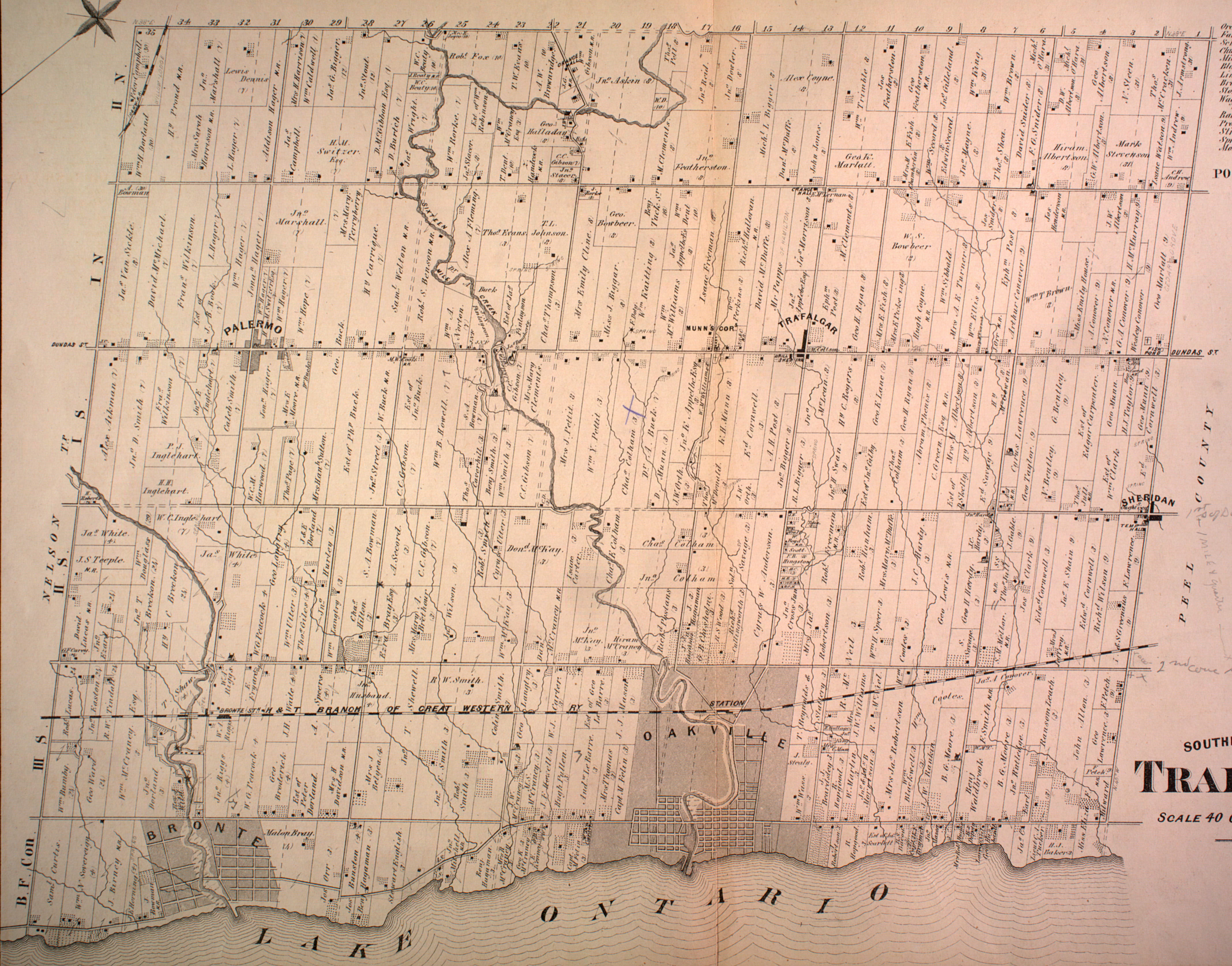
Lakeshore Road begins in Burlington beside the Burlington Bay James N. Allan Skyway (which carries the Queen Elizabeth Way over the canal cut across the sandbar separating Hamilton Harbour from the main body of Lake Ontario) where Eastport Drive continues an offramp from the QEW. The road formerly interlined with Beach Boulevard in Hamilton via the Burlington Canal Lift Bridge (and was formerly a part of Highway 20 through this stretch), but the construction of Eastport Drive in 1982 resulted in that link being severed as the new road was routed over the bridge. [2] [ failed verification ] Lakeshore proceeds along Burlington Beach as a three-lane road (the third being a centre turning lane), passing the Joseph Brant Hospital. It comes to the intersection of North Shore Boulevard, where it turns right, the former Highway 2 came in from the west to follow its course eastwards, and where Highway 20 terminated. [3]

The road continues east along the downtown Burlington waterfront and passes the Brant Street Pier. East of downtown, Lakeshore enters a long, predominantly wealthy, leafy residential stretch consisting of a mix of lakefront mansions, parklands, and a few apartment buildings, a setting which characterizes the road through most of Halton Region. Upon entering Oakville, the street passes through an area of newer residential developments that were built on the site of a closed oil refinery; the Shell Oakville Refinery. Shortly thereafter, Lakeshore crosses the Bronte Creek and enters the once-independent historic Bronte Village. After passing through more residential areas, it travels through Kerr Village, crosses the Sixteen Mile Creek and comes into downtown Oakville. Further east, the road continues on through the Eastlake neighbourhood before leaving Oakville at Winston Churchill Boulevard.

Lakeshore Road in Port Credit, Mississauga Lakeshore Rd E 2021.jpg
Lakeshore Road in Port Credit, Mississauga

The posh residential surroundings end abruptly as Lakeshore enters Mississauga (and Peel Region), coming into a semi-rural industrial zone which contains a cement plant and another oil refinery; the Mississauga Lubricants Centre, among other industries. [4] At the refinery, the road bends sharply to the left and turns into Southdown Road, along which it jogs north for 2 kilometres (1.2 mi) until reaching Royal Windsor Drive in Clarkson Village, where it turns right, widens to four lanes, and returns to attractive surroundings once again. East of Clarkson, it passes through Lorne Park, originally a cottage resort community, and Jack Darling Park. Lakeshore then enters another historic district, Port Credit, crosses the Credit River, and intersects Hurontario Street (formerly Highway 10), which is Mississauga's main street and a historic route to Collingwood. Beyond Port Credit, the street traverses older and more typical mixed residential and commercial suburban areas through Lakeview, where the Lakeview Generating Station, a coal-fired power plant decommissioned in 2005, was located. Lakeshore ends at Mississauga's eastern boundary at the Etobicoke Creek beside Marie Curtis Park, where it continues as Toronto's Lake Shore Boulevard.

History

Establishment of the route

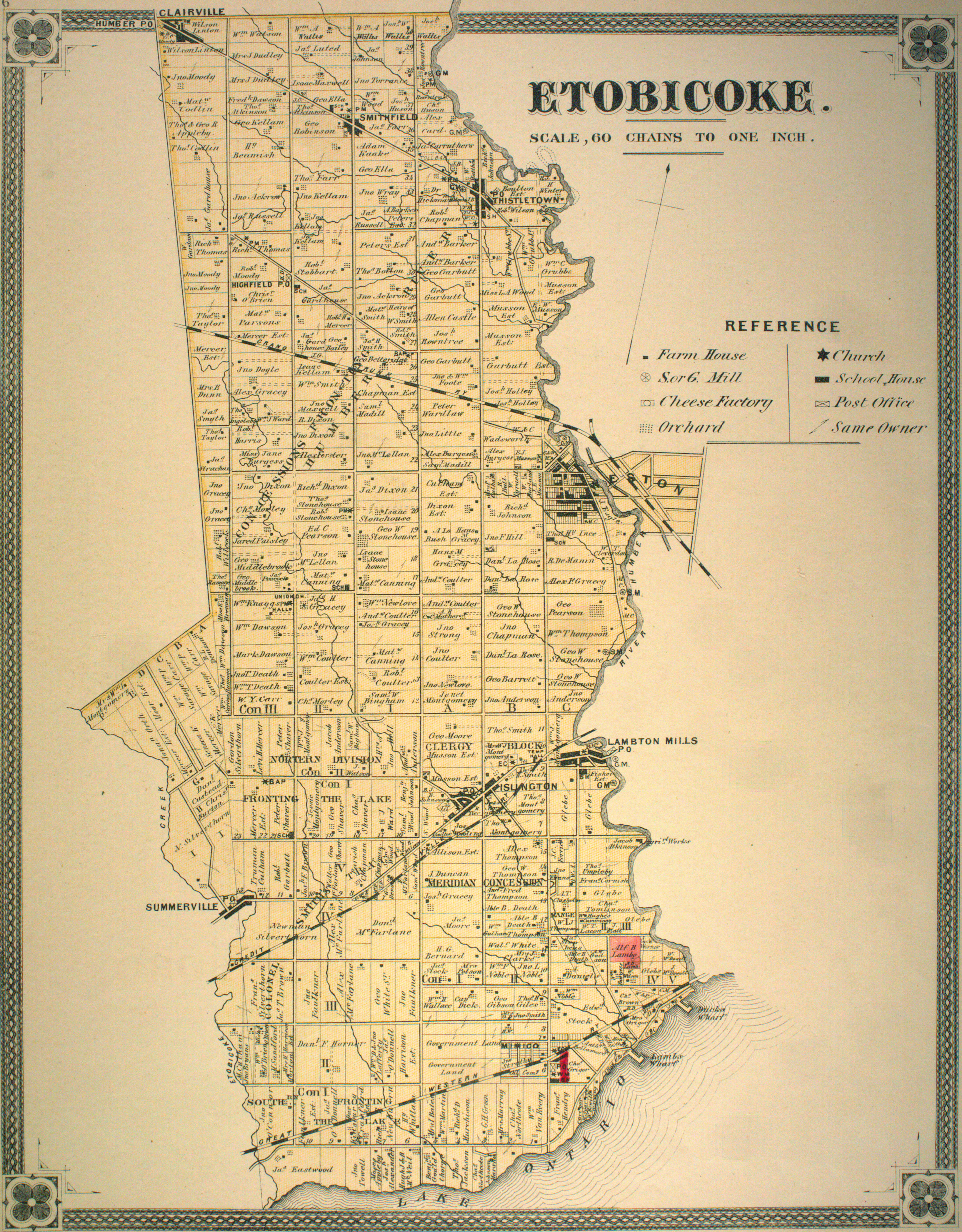
Lakeshore Road originated as a Native trail running along the shore of Lake Ontario east from the vicinity of present-day downtown Burlington as far as today's Fourth Line in Oakville. Later, in the colonial era, after the concession road system was laid out, it was improved and linked to continue east along the Third Concession South of Dundas Street, [5] [ failed verification ] in the historic Nelson, Trafalgar, and Toronto townships; and the First Concession in Etobicoke Township. [6] [ failed verification ] The sections in the old village cores of Burlington, Bronte, and Oakville, were named Water Street, Triller Street, and Colborne Street, respectively. [7] [8]

Street railways on Lakeshore

An interurban radial line operated by the Toronto and Mimico Electric Railway and Light Company ran along (then) "Lake Shore" Road beginning in 1892, running west as a short stub from Parkdale in Toronto to the Humber River. The line was extended to Mimico on July 10, 1893 and reached Long Branch on July 1, 1895. It arrived in Port Credit, first to Hurontario Street on December 24, 1905, and then to the Credit River, on November 19 of the following year.

The line was proposed to be extended to Oakville to meet up with the Hamilton Radial Electric Railway interurban line running from Hamilton on a private right-of-way north of the road, but the connection was never constructed due to financial difficulties.

Long Branch Loop in 1935, showing the last radial car to go west to Port Credit LongBranchLoop.jpg
Long Branch Loop in 1935, showing the last radial car to go west to Port Credit

The line was taken over by the Toronto Transportation Commission on December 1, 1920, and in 1928 the portion from Mimico to Long Branch was converted to a double-track urban streetcar line which still carries cars along Lake Shore Blvd. in Toronto to the present day. The remainder of the route west to Port Credit was abandoned in 1935, due to competition from automobiles and intercity bus service. [9] The Hamilton Radial Electric Railway's radial line shut down completely in 1929. [10]

But street railways would return to Lake Shore Road west of Toronto, albeit only temporarily: During World War II. the TTC extended its Long Branch route tracks a short distance into Toronto Township (now Mississauga) and ran city streetcars to serve an armaments factory from October 1942 until October 1945, but removed them shortly after the end of the war. [11]

Upgrading to highway status

Lake Shore Road was macadamized during the 19th century, although it was frequently damaged by erosion.[ citation needed ] With the advent of automobile use in the early 20th century, it was chosen as the route of the proposed Toronto–Hamilton Highway in 1914 [12] as part of the Provincial Highway (Highway 2). The Toronto-to-Hamilton highway which, when completed in 1917, was both Ontario's first concrete highway and one of the longest such inter-city stretches in the world. [13]

Over the next decade, vehicle usage increased substantially, and by 1920 Lake Shore Road was again congested, particularly during weekends. [14] In response, the Department of Highways examined improving another road between Toronto and Hamilton. The road was to be more than twice the width of Lake Shore Road at 12 m (39 ft) and would carry two lanes of traffic in either direction. [15] The new highway was named The Middle Road , which later became the Queen Elizabeth Way. As a result of the new highway, Lake Shore was relieved of its heavy traffic, and was able to retain its narrow width for most of its length, which it still has today.

At about the same time, Lake Shore Rd. was extended east towards Exhibition Place, and in the 1950s, all the way into downtown Toronto and beyond. The portion in what became Metropolitan Toronto was rechristened as Lake Shore Boulevard during this time period, officially truncating it to the Etobicoke Creek at what is today's Mississauga-Toronto city limits.

Related Research Articles

<span class="mw-page-title-main">Oakville, Ontario</span> Town in Ontario, Canada

Oakville is a town in Halton Region, Ontario, Canada. It is located on Lake Ontario between Toronto and Hamilton. At its 2021 census population of 213,759, it is Ontario's largest town. Oakville is part of the Greater Toronto Area, one of the most densely populated areas of Canada.

<span class="mw-page-title-main">Etobicoke</span> District of Toronto, Ontario, Canada

Etobicoke is an administrative district and city within Toronto, Ontario, Canada. Comprising the city's west-end, Etobicoke is bordered on the south by Lake Ontario, on the east by the Humber River, on the west by Etobicoke Creek, the cities of Brampton, and Mississauga, the Toronto Pearson International Airport, and on the north by the city of Vaughan at Steeles Avenue West.

The Queen Elizabeth Way (QEW) is a 400-series highway in the Canadian province of Ontario linking Toronto with the Niagara Peninsula and Buffalo, New York. The freeway begins at the Peace Bridge in Fort Erie and travels 139.1 kilometres (86.4 mi) around the western end of Lake Ontario, ending at Highway 427 as the physical highway continues as the Gardiner Expressway into downtown Toronto. The QEW is one of Ontario's busiest highways, with an average of close to 200,000 vehicles per day on some sections. Major highway junctions are at Highway 420 in Niagara Falls, Highway 405 in Niagara-on-the-Lake, Highway 406 in St. Catharines, the Red Hill Valley Parkway in Hamilton, Highway 403 and Highway 407 in Burlington, Highway 403 at the Oakville–Mississauga boundary, and Highway 427 in Etobicoke. Within the Regional Municipality of Halton the QEW is signed concurrently with Highway 403. The speed limit is 100 km/h (62 mph) throughout most of its length, with the exceptions being between Hamilton and St. Catharines where the posted limit is 110 km/h (68 mph).

<span class="mw-page-title-main">New Toronto</span> Neighbourhood in Toronto, Ontario, Canada

New Toronto is a neighbourhood and former municipality in Toronto, Ontario, Canada. It is located in the south-west area of Toronto, along Lake Ontario. The Town of New Toronto was established in 1890, and was designed and planned as an industrial centre by a group of industrialists from Toronto who had visited Rochester, New York. New Toronto was originally a part of the Township of Etobicoke. It was an independent municipality from 1913 to 1967, being one of the former 'Lakeshore Municipalities' amalgamated into the Borough of Etobicoke, and eventually amalgamated into Toronto. The neighbourhood has retained the name.

<span class="mw-page-title-main">Mimico</span> Neighbourhood in Toronto, Ontario, Canada

Mimico is a neighbourhood in Toronto, Ontario, Canada, being located in the south-west area of Toronto on Lake Ontario. It is in the south-east corner of the former Township of Etobicoke, and was an independent municipality from 1911 to 1967.

King's Highway 403, or simply Highway 403, is a 400-series highway in the Canadian province of Ontario that travels between Woodstock and Mississauga, branching off from and reuniting with Highway 401 at both ends and travelling south of it through Hamilton and Mississauga. It is concurrent with the Queen Elizabeth Way (QEW) for 22 km (14 mi) from Burlington to Oakville. The Highway 403 designation was first applied in 1963 to a short stub of freeway branching off the QEW, and the entire route was completed on August 15, 1997, when the section from Brantford to the then-still independent Town of Ancaster was opened to traffic. The section of Highway 403 between Woodstock and Burlington was formally dedicated as the Alexander Graham Bell Parkway on April 27, 2016, in honour of Alexander Graham Bell.

<span class="mw-page-title-main">Lake Shore Boulevard</span> Street in Toronto

Lake Shore Boulevard is a major arterial road running along more than half of the Lake Ontario waterfront in the city of Toronto, Ontario, Canada. Prior to 1998, two segments of Lake Shore Boulevard were designated as part of Highway 2, with the highway following the Gardiner Expressway between these two sections.

<span class="mw-page-title-main">Kipling Avenue</span> Road in Toronto, Canada

Kipling Avenue is a street in the cities of Toronto and Vaughan in Ontario, Canada. It is a concession road, 6 concessions (12 km) west from Yonge Street, and is a major north–south arterial road. It consists of three separate sections, with total combined length of 26.4 km. (16.4 mi.).

<span class="mw-page-title-main">Bronte, Ontario</span> Unincorporated community in Ontario, Canada

Bronte is the community that makes up much of the west end of Oakville, in Ontario, Canada. Twelve Mile Creek flows through the middle of town and empties into Lake Ontario. Main roads include Bronte Road (north-south), Lakeshore Road West and Rebecca Street (east-west). Streets in the business section include Lakeshore, Jones, Marine, and Ontario Street. Bronte is also accessed via a superhighway located to the north of the former village. Other main roads include Third Line, Speers Road and Burloak Drive to the west

King's Highway 5, commonly referred to as Highway 5 and historically as the Dundas Highway and Governor's Road, is a provincially maintained highway in the Canadian province of Ontario. The east–west highway travels a distance of 12.7 km (7.9 mi) between Highway 8 at Peters Corners, north of Hamilton, and Highway 6 at Clappison's Corners. Prior to several sections being downloaded to the municipalities in which they were located, Highway 5 served as bypass to Highway 2, connecting with it in both Paris and Toronto, a distance of 114.3 km (71.0 mi).

<span class="mw-page-title-main">Toronto and Mimico Electric Railway and Light Company</span> Former operator of the Mimico radial line in Toronto

The Toronto and Mimico Electric Railway and Light Company was incorporated in 1890, and operated the Mimico radial line in the Toronto area. The line started operation in 1892 as a short suburban line that later was extended to Port Credit. In 1904, the railway was acquired by the Toronto and York Radial Railway (T&YRR) and became the T&YRR Mimico Division. In 1922, the City of Toronto acquired the T&YRR and contracted Ontario Hydro to manage the four T&YRR lines including the Mimico line. In 1927, the TTC took over the operation of the Mimico line and extended its service eastward to Roncesvalles Avenue. In 1928, the TTC double-tracked the line from Humber to Long Branch and made that portion part of the Lake Shore streetcar line. The portion beyond Long Branch to Port Credit became the Port Credit line, and continued operation as a single-track radial line until its closure on February 9, 1935.

<span class="mw-page-title-main">Islington-City Centre West</span> Neighbourhood in Toronto, Ontario, Canada

Islington-City Centre West is a commercial and residential neighbourhood in Toronto, Ontario, Canada. One of four central business districts outside Downtown Toronto, it is bounded by Rathburn Road to the north, Islington Avenue to the east, Bloor Street to the south, Mimico Creek to the west.

<span class="mw-page-title-main">The Queensway–Humber Bay</span> Neighbourhood in Toronto, Ontario, Canada

The Queensway–Humber Bay, known officially as Stonegate–Queensway, is a neighbourhood in the southwest of Toronto, Ontario, Canada. It is located in the southeast area of the former City of Etobicoke.

<span class="mw-page-title-main">Royal York Road</span> Thoroughfare in Toronto, Ontario

Royal York Road, historically known as Church Street or New Church Street, is a north-south arterial road in Toronto, Ontario, Canada. It is a concession road, 5 concessions (10 km) west of Yonge Street, and runs through many residential neighbourhoods, most notably Mimico and the Kingsway. It is classified as a "minor arterial" road by the city of Toronto.

<span class="mw-page-title-main">Long Branch, Toronto</span> Neighbourhood in Toronto, Ontario, Canada

Long Branch is a neighbourhood and former municipality in the south-west of Toronto, Ontario, Canada. It is located in the south-western corner of the former Township of Etobicoke on the shore of Lake Ontario. The Village of Long Branch was a partially independent municipality from 1930 to 1967. Long Branch is located within a land grant from the government to Colonel Samuel Smith in the late 18th century. After Smith's death, a small portion of it was developed as a summer resort in the late 1800s.

The Middle Road was the name for a historic highway in the Canadian province of Ontario, which served to link the cities of Toronto and Hamilton. The name was used between 1931 and 1939, after which the road became the northern section of the Queen Elizabeth Way. It borrowed the name of Middle Road from a concession road in Toronto Township between 1st Concession South and 2nd Concession South during the early 1800s.

<span class="mw-page-title-main">Long Branch Loop</span> Streetcar loop in Toronto, Canada

Long Branch Loop is the westernmost streetcar stop within the Toronto streetcar system, operated by the Toronto Transit Commission (TTC). It is located in the Long Branch neighbourhood in southwestern Toronto, close to the boundary with Mississauga. Long Branch Loop is the western terminus for four streetcar routes but is principally served by the 507 Long Branch route. Several TTC and MiWay bus routes terminate at the loop.

<span class="mw-page-title-main">Burnhamthorpe Road</span> Road in the Greater Toronto Area in Ontario, Canada

Burnhamthorpe Road is a major arterial road in the cities of Toronto and Mississauga, Ontario; beginning at Dundas Street, near Islington Avenue, running west and becoming a rural road in the Town of Oakville, where it terminates at Tremaine Road, where it changes name.

<span class="mw-page-title-main">Dundas Street</span> Major arterial road in Ontario, Canada

Dundas Street is a major historic arterial road in Ontario, Canada. The road connects the city of Toronto with its western suburbs and several cities in southwestern Ontario. Three provincial highways—2, 5, and 99—followed long sections of its course, although these highway segments have since been downloaded to the municipalities they passed through. Originally intended as a military route to connect the shipping port of York to the envisioned future capital of London, Ontario, the street today connects Toronto landmarks such as Yonge–Dundas Square and the city's principal Chinatown to rural villages and the regional centres of Hamilton and London.

References

  1. Google (March 31, 2017). "Lakeshore Road route minus the 2 km. jog" (Map). Google Maps . Google. Retrieved March 31, 2017.
  2. "1974 photo of Burlington Canal Lift Bridge and road network". thekingshighway.ca.
  3. "History of King's Highway 20:". thekingshighway.ca.[ self-published source ]
  4. "Google Maps view of transition of Lakeshore Rd. from residential to industrial".
  5. "Southern Trafalgar Township map". The Canadian County Atlas Digital Project. McGill University.
  6. "Etobicoke Township map". The Canadian County Atlas Digital Project. McGill University.
  7. "'Downtown' Burlington - 1877". Burlington's History: Maps.
  8. "Postcard: Triller and Trafalgar Streets, Bronte, Ont". Trafalgar Township Historical Society Digital Collections.
  9. "Route 507 - The Long Branch Streetcar (Deceased)". Transit Toronto.
  10. "The Last Days". The Hamilton Radial Electric Railway (HRER).
  11. "The Short History of Small Arms Loop". Transit Toronto.
  12. "Toronto–Hamilton Highway Proposed". The Toronto World. January 22, 1914. p. 14. Retrieved March 23, 2017 via Google News.
  13. Shragge p. 55 "...the Toronto-to-Hamilton highway which, when completed in 1917, was both Ontario's first concrete highway and one of the longest such inter-city stretches in the world."[ full citation needed ]
  14. "Increased Volume of Traffic". County And Suburbs. Toronto World. June 26, 1920. p. 7. Retrieved February 12, 2010 via Google News.
  15. Shragge pp. 79–81.[ full citation needed ]