Lakewood Village, Long Beach, California

Last updated • 5 min readFrom Wikipedia, The Free Encyclopedia

Lakewood Village
Nickname: 
The Village
Lakewood Village, Long Beach, California
Coordinates: 33°50′27″N118°07′56″W / 33.8408°N 118.1321°W / 33.8408; -118.1321
Country Flag of the United States.svg United States
State Flag of California.svg  California
County Flag of Los Angeles County, California.svg Los Angeles
City Flag of Long Beach, California.png Long Beach

Lakewood Village, or simply known as The Village, is a neighborhood in the northeast portion of the city of Long Beach, California. It is bordered on the west, north and east sides by the City of Lakewood. It is located south of Del Amo Boulevard, north of Carson Street, east of Lakewood Boulevard and west of Bellflower Boulevard.

Contents

History

Between 1869 and 1897, the Rancho Los Cerritos land skyrocketed in value - from $5,000 for the entire ranch in 1869, to $50 an acre in 1897—when the Bixby Investment Company sold to the brothers William A. Clark and J. Ross Clark of Montana. In 1897, the Clarks purchased 8,139 acres of rancho land for $405,000. The land extended from Signal Hill to Bellflower and from Cherry Avenue to the San Gabriel River. [1]

In 1904, the future sites of the City of Lakewood and of the Lakewood Village in the City of Long Beach came under the ownership of the Clarks' newly formed Montana Land Company. The farming operation was named "Montana Ranch", with 2,000 acres of the land devoted to sugar beets and the remainder of the acreage was devoted to raising alfalfa and to pasture for dairy cattle and sheep. [1]

When William A. Clark and his brother J. Ross Clark died (in 1925 and 1936 respectively), management of the Montana Ranch passed to J. Ross Clark's nephew, Clark J. Bonner, a Los Angeles insurance executive. When the Los Alamitos sugar mill closed in 1926, due to declining beet production, Bonner envisioned turning part of the Montana Ranch into an upper-middle-class suburb to take advantage of the local real estate boom due to the discovery of oil wells. The new subdivision was a leisurely commute from downtown Long Beach, removed from the smells and noise of the oil fields around Signal Hill, and 25 miles away from downtown Los Angeles. [1]

By the early 1930s, Bonner has filed his plans and turned to noted Charles B. Hopper to subdivide the land and sell house lots. In August 1932, the Los Angeles Times announced "Huge New Tract Launched; 9,000 Acre Development Near Los Alamitos Being Built Around Golf Course Project." It is suggested that Bonner selected the name "Lakewood" because 1) the land featured boggy remains of the former Bouton Lake, and 2) he named it after the winter resort of Lakewood, New Jersey where his uncle William A. Clark had built estates at the end of the 19th century. [1]

Several houses had been built in the rural area known as Lakewood Village. The houses were favored with a pleasant setting and the proximity of the Lakewood Country Club. It has been suggested that Bouton Lake, located on the golf course and formed in 1895 when drilling operations opened an artesian well, is the source for the name “Lakewood.”

The Second World War began an era of profound change for the future Lakewood area. The Douglas Aircraft Company completed a massive defense plant and home for the Douglas workers were begun in what is now Lakewood Village. Yet even as the defense workers moved into their new homes, the fields between South Street and Lakewood Village remained empty.

By 1949, most of the land comprising west Lakewood—some 3,500 acres (14 km2)—had been purchased for nearly $9 million by Louis Boyar, Ben Weingart, and Mark Taper. From their experience as homebuilders in Long Beach and Norwalk, they knew that the Lakewood area was ready for planned development. Together, they formed the Lakewood Park Corporation and, with the financial assistance of the Prudential Insurance Company, began building the first of 17,000 new homes.

Setting

A number of architectural styles are found in this neighborhood, with styles including: English Tudor, Cape Cod, Country, French Country, Medieval, Ranch, Spanish Colonial, Mediterranean, Contemporary, Asian, Tropical/Tiki, Streamline Moderne/Art Deco, Craftsman, and many more.

Lakewood Village is located in the center of the Lakewood/Long Beach area, and is close to the 91, 710, 605 and 405 Freeways. Lakewood Village is part of the 90808 ZIP Code that also includes communities such as the El Dorado Park Estates, Los Altos, and Rancho Park Estates.

The Village Shoppes

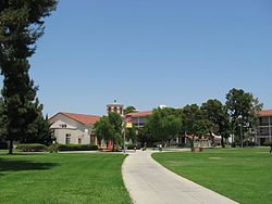
Along Viking Way (the southeast corner of Lakewood Village). Since the 1950s, "Parkview Village" (originally known as "The Triangle") has included a collection of shops, restaurants, and service providers along Viking Way and Village Road in the heart of the residential community of Lakewood Village. The Village is located at the intersection of Bellflower Boulevard and Carson Street adjacent to Heartwell Park and the Long Beach City College Liberal Arts Campus, and near Long Beach Municipal Airport and Skylinks Golf Course. Parkview Village has the characteristics of an outdoor shopping "main street" with over 100,000 square feet (10,000 m2) and more than seventy businesses.


Along Norse Way (the southwest corner of Lakewood Village). This shopping center, built in 1941, was originally used by the Douglas Aircraft Company workers. The Sunnyspot Diner, Bank of America, grocery store and ration stamp office have since left. It was the beginning of Lonnies Sporting Goods, Rex L. Hodges Real Estate and the First Lakewood Village Walk In Theater. Rexall Drugs and a malt shop are fond memories of early LBCC Students. A wide variety of stores and businesses are offered along this street. One can find several restaurants ranging from Thai, Vietnamese, Chinese, Greek, Mexican, and even Classic American food from Dale's Diner. These shops are located near the intersection of Lakewood Boulevard and Carson Street. Many of these businesses offer discounts to Boeing employees since Boeing is located just across the street. The shops are also near the Long Beach City College Liberal Arts Campus.

Schools

The Long Beach City College's Liberal Arts Campus is located in Lakewood Village LBCC LAC Bldg A.jpg
The Long Beach City College's Liberal Arts Campus is located in Lakewood Village

Part of the Long Beach Unified School District, this area's schools include Mark Twain Elementary School and Bancroft Middle School, both California Distinguished Elementary Schools. There are several Christian elementary schools at local churches in the Village. The area high school is Lakewood High School. Long Beach City College's Liberal Arts Campus is also located in the Village.

Notable residents

See also

Related Research Articles

<span class="mw-page-title-main">Long Beach, California</span> City in California, United States

Long Beach is a coastal city in southeastern Los Angeles County, California, United States. It is the 44th-most populous city in the United States, with a population of 451,307 as of 2022. A charter city, Long Beach is the 7th-most populous city in California, the 2nd-most populous city in Los Angeles County, and the largest city in California that is not a county seat.

<span class="mw-page-title-main">Hawaiian Gardens, California</span> City in California, United States

Hawaiian Gardens is a city in Los Angeles County, California, United States. It is the smallest city in the county in area and was incorporated on April 9, 1964. The population was 14,149 at the 2020 census, down slightly from 14,254 at the 2010 census.

<span class="mw-page-title-main">Manhattan Beach, California</span> City in California, United States

Manhattan Beach is a city in southwestern Los Angeles County, California, United States, on the Pacific coast south of El Segundo, west of Hawthorne and Redondo Beach, and north of Hermosa Beach. As of the 2020 census, the population was 35,506.

<span class="mw-page-title-main">Los Alamitos, California</span> City in California, United States

Los Alamitos is a city in Orange County, California. The city was incorporated in March 1960. The population was 11,780 at the 2020 census, up from 11,449 at the 2010 census. The adjacent unincorporated community of Rossmoor uses the same 90720 ZIP code in its mailing address, but is not part of the city. The Los Alamitos Race Course is named for the city, but lies in the neighboring city of Cypress.

<span class="mw-page-title-main">California State Route 19</span> State highway in Los Angeles County, California, United States

State Route 19 is a state highway in the U.S. state of California, running along Lakewood Boulevard and Rosemead Boulevard in the Los Angeles area. An additional "hidden" state highway, State Route 164, is also signed as part of SR 19, despite having a legal description separate from Route 19. The combined route is a north–south four-to-six lane suburban roadway, lying east of the Long Beach Freeway and west of the San Gabriel River Freeway, and connecting the eastern parts of Long Beach and Pasadena via the Whittier Narrows. Under their legal descriptions, SR 19 runs north to Gallatin Road in Pico Rivera, then SR 164 goes from Gallatin Road to Pasadena. Since 1998, several pieces have been relinquished to local governments, and more transfers are authorized by state law.

The Long Beach Unified School District is a school district headquartered in Long Beach, California, United States. Established in 1885, Long Beach Unified School District now educates 81,000 students in 84 public schools in the cities of Long Beach, Lakewood, Signal Hill, Carson, and Avalon on Catalina Island. The school district is the third largest in California and serves one of the most diverse large cities in the United States. The student population is 53.1 percent Hispanic, 15.6 percent African American, 15.2 percent white, 11.2 percent Asian, 3 percent multi-race, 1.7 percent Pacific Islander and 0.2 percent Native American. More than two-thirds of the student population come from lower-income households and qualify for free and reduced price meals. The school district employs more than 8,000 people, making it the largest employer in Long Beach.

<span class="mw-page-title-main">California's 44th congressional district</span> U.S. House district for California

California's 44th congressional district is a congressional district in the U.S. state of California. The district is centered in South Los Angeles and the Los Angeles Harbor Region. It is currently represented by Democrat Nanette Barragán. The 44th district was created as a result of the redistricting cycle after the 1980 census.

<span class="mw-page-title-main">North Long Beach, Long Beach, California</span> Neighborhood of Long Beach in Los Angeles, California, United States

North Long Beach is a predominantly working-class area of Long Beach, California. The neighborhood is bounded to the west, north and east by the Long Beach city limits, and to the south by a Union Pacific railroad track and the Bixby Knolls neighborhood. The north boundary with Paramount is only a few blocks north of the Artesia Freeway.

Bixby Knolls is a neighborhood in Long Beach, California, named after the Bixby family.

<span class="mw-page-title-main">Puvunga</span> Indigenous sacred site in Long Beach, California, US

Puvunga is an ancient village and sacred site of the Tongva nation, the Indigenous people of the Los Angeles Basin, and the Acjachemen, the Indigenous people of Orange County. The site is now located within the California State University, Long Beach campus and surrounding areas. The Tongva know Puvunga as the "place of emergence" and it is where they believe "their world and their lives began". Puvunga is an important ceremonial site and is the terminus of an annual pilgrimage for the Tongva, Acjachemen, and Chumash.

<span class="mw-page-title-main">Rancho Los Alamitos</span> Historic house in California, United States

Rancho Los Alamitos takes its name from an 1834 Mexican partition of the 1784 Rancho Los Nietos, a Spanish concession, covering an area in present-day California's southwestern Los Angeles County and northwestern Orange County. Los Alamitos means the Little Cottonwoods or Poplars in Spanish, after the native Fremont Cottonwood trees there.

<span class="mw-page-title-main">Los Cerritos Ranch House</span> Historic house in California, United States

Los Cerritos Ranch House, also known as Rancho Los Cerritos or Casa de los Cerritos, in Long Beach, California, was "the largest and most impressive adobe residence erected in southern California during the Mexican period". Los Cerritos means "the little hills" in English. It was declared a National Historic Landmark in 1970. It is currently a museum.

The Southern California Association of Governments (SCAG) is the metropolitan planning organization (MPO) of six of the ten counties in Southern California, serving Imperial County, Los Angeles County, Orange County, Riverside County, San Bernardino County, and Ventura County. San Diego County's MPO is the San Diego Association of Governments, which is an unrelated agency.

<span class="mw-page-title-main">Alamitos Beach, Long Beach, California</span> Neighborhood in Long Beach, California, US

Alamitos Beach is a coastal neighborhood in the southern portion of the city of Long Beach, California. Although it was in unincorporated Los Angeles County when annexed by the City of Long Beach, it had been planned as its own community with a townsite.

<span class="mw-page-title-main">Rosecrans Avenue</span> Street in Los Angeles

Rosecrans Avenue is a major west-east thoroughfare in Los Angeles and Orange Counties, California, USA. It has a total length of 27.5 miles (44.3 km). The street is named after U.S. Union General William S. Rosecrans, who purchased 13,000 acres (5,300 ha) of Rancho Sausal Redondo southwest of Los Angeles in 1869. Rosecrans Avenue was originally named Drexel Avenue, and ran through the Rosecrans Rancho which is part of modern-day Gardena.

Rancho Los Cerritos was a 27,054-acre (109.48 km2) 1834 land grant in present-day southern Los Angeles County and Orange County, California The grant was the result of a partition of the Rancho Los Nietos grant. "Cerritos" means "little hills" in Spanish. The rancho lands include the present-day cities of Cerritos, Paramount, Bellflower and Long Beach.

<span class="mw-page-title-main">Lakewood, California</span> City in California, United States

Lakewood is a city in Los Angeles County, California, United States. The population was 82,496 at the 2020 census. It is bordered by Long Beach on the west, northwest and south, Bellflower on the north, Cerritos on the northeast, Cypress on the east, and Hawaiian Gardens on the southeast. Major thoroughfares include Lakewood, Bellflower, and Del Amo Boulevards and Carson and South Streets. The San Gabriel River Freeway (I-605) runs through the city's eastern regions.

<span class="mw-page-title-main">Bixby family</span> California real estate family

The Bixby family is an American family that was heavily involved in the development of California ranches and real estate in the 19th and 20th centuries. Through various companies, they controlled at one time or another large swathes of California real estate, much of it derived from Mexican land grants. Over several generations, their holdings included Rancho Los Cerritos and Rancho Los Alamitos, and parts of Rancho San Justo and Rancho Palos Verdes, totaling well over 100,000 acres. Parts of the towns of Long Beach, Bellflower, Paramount, Signal Hill, Lakewood, and Los Alamitos emerged from former Bixby-held lands. Within Long Beach, the neighborhoods Bixby Hill, Bixby Knolls, and Bixby Village are named after the family, as well as Bixby Park in the Alamitos Beach neighborhood.

The Bixby land companies were a group of California-based land companies founded by various members of the Bixby and Flint families from Maine. In the late 19th and early 20th centuries, the firms of Flint, Bixby & Company, J. Bixby & Company, J. W. Bixby & Company, the Alamitos Land Company, and the Bixby Land Company controlled large swathes of California real estate, much of it derived from Mexican land grants. At various times their holdings included Rancho Los Cerritos, Rancho Los Alamitos, half of Rancho San Justo, and part of Rancho Palos Verdes together with other property in San Benito, Santa Barbara, and Los Angeles counties. Parts of the towns of Long Beach, Bellflower, Paramount, Signal Hill, Lakewood, and Los Alamitos emerged from former Bixby-held lands.

Los Altos Center is a regional shopping mall in the Los Altos area of northeastern Long Beach, California along Bellflower Boulevard, 4 miles south of Lakewood Center Mall and 5 miles east of Downtown Long Beach.

References

  1. 1 2 3 4 "City of Lakewood, California - Lakewood History Chapter 1". www.lakewoodcity.org. Retrieved 2019-06-19.