Guisborough is a market town and civil parish in the borough of Redcar and Cleveland, North Yorkshire, England. It lies north of the North York Moors National Park. Roseberry Topping, midway between the town and Great Ayton, is a landmark in the national park. It was governed by an urban district and rural district in the North Riding of Yorkshire.

Redcar and Cleveland is a unitary authority area with borough status in the ceremonial county of North Yorkshire, England. Its council has been a unitary authority since 1996.
Bodelwyddan is a village, electoral ward and community in Denbighshire, Wales, approximately 5 miles (8 km) south of Rhyl. The parish includes several smaller hamlets such as Marli and Pengwern.
Loftus is a market town and civil parish in the Redcar and Cleveland borough of North Yorkshire, England. The town is located north of the North York Moors and sits between Whitby and Skelton-in-Cleveland. The parish includes the villages of Carlin How, Easington, Liverton, Liverton Mines and Skinningrove. It is near Brotton, Saltburn and Skelton-in-Cleveland.

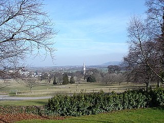
Great Ayton is a village and civil parish in North Yorkshire, England. The River Leven flows through the village, which lies just north of the North York Moors. According to the 2021 Census, the parish has a population of 4,346.

Langbaurgh was a liberty or wapentake of the North Riding of Yorkshire. It covered an area of the shire's north-eastern tip. The wapentake took its name from Langbaurgh hamlet, in present-day Great Ayton parish.

Nunthorpe is a village and civil parish in the Borough of Middlesbrough in North Yorkshire, England.
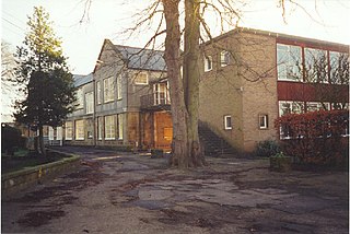
Great Ayton Friends' School (1841–1997) in Great Ayton, North Yorkshire, England, was a private, co-educational, agricultural boarding school, run by the Religious Society of Friends.
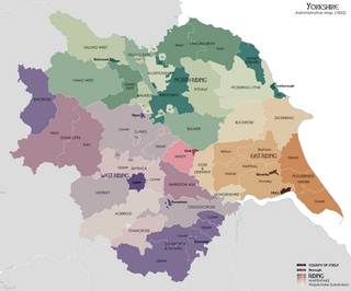
Langbaurgh West was a division of the wapentake of Langbaurgh in the North Riding of the ancient county of Yorkshire. The area along with Langbaurgh East forms the Anglo-Saxon baronial Liberty of Cleveland and roughly covers the modern districts of Middlesbrough, the western, urbanised portion of Redcar & Cleveland, the southern portion of Stockton-on-Tees, the northern parts of Hambleton and the northern parts of the Borough of Scarborough.

Ingleby Greenhow is a village and civil parish in the former Hambleton District of North Yorkshire, England. It is on the border of the North York Moors and 3 miles (4.8 km) south of Great Ayton.

Kildale is a village and civil parish in Hambleton district of North Yorkshire, England. It lies approximately 3 miles (4.8 km) south-east from Great Ayton, within the North York Moors National Park and on the Cleveland Way National Trail. The parish occupies 5,730 acres (23.2 km2), with 3,416 acres (13.82 km2) being taken up by moorland.

Great Hinton is a small village and civil parish about 3 miles (4.8 km) south of Melksham and 3.5 miles (5.6 km) north-east of Trowbridge in Wiltshire, England. The parish includes the hamlets of Bleet and Cold Harbour.
The High Sheriff of Cleveland was a High Sheriff title which was in existence from 1974 until 1996, covering Cleveland, England.

Great Broughton is a village in the Great and Little Broughton civil parish of the Hambleton District of North Yorkshire in northern England.

Kettleness, is a hamlet in the Scarborough District of North Yorkshire, England. The settlement only consists of half-a-dozen houses, but up until the early 19th century, it was a much larger village. However, most of that village, which was on the headland, slipped into the sea as a result of instability caused by quarrying for the alum industry. Kettleness became a smaller settlement, with houses rebuilt slightly further inland.

The Church of All Saints is a grade I listed building and former parish church for Great Ayton, North Yorkshire, England. The churchyard is known to contain several graves to family members of Captain Cook, a noted seafarer.

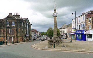
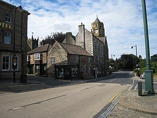
Stokesley Town Hall is a municipal building in the Market Place in Stokesley, North Yorkshire, England. The structure, which accommodates the offices and meeting place of Stokesley Town Council, is a grade II listed building.
Pickering Lythe was one of twelve wapentakes within the historical county of the North Riding of Yorkshire, England. It was recognised within the Domesday Book as Dic, an area covering the Vale of Pickering, and swathes of land east towards the North Yorkshire coast.
Great Ayton is a civil parish in the former Hambleton District of North Yorkshire, England. It contains 64 listed buildings that are recorded in the National Heritage List for England. Of these, one is listed at Grade I, the highest of the three grades, one is at Grade II*, the middle grade, and the others are at Grade II, the lowest grade. The parish contains the village of Great Ayton, the smaller settlement of Langbaurgh, and the surrounding countryside and moorland. Most of the listed buildings are houses, cottages and associated structures, farmhouses and farm buildings. The others include churches and items in a churchyard, a former chapel, a shooting box, boundary stones, schools, a police station, a memorial and a telephone kiosk.
