
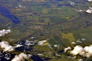
The Fishing Lakes, also called the Calling Lakes or the Qu'Appelle Lakes, are a chain of four lakes in the Qu'Appelle Valley cottage country about 40 miles (64 km) to the north-east of Regina in the Canadian province of Saskatchewan. The lakes are in a region called the Prairie Pothole Region of North America, which extends throughout three Canadian provinces and five U.S. states. It is also within Palliser's Triangle and the Great Plains ecoregion. The Fishing Lakes all follow the course of the Qu'Appelle River, which flows from the west to the east and is part of the Hudson Bay drainage basin. The lakes sit in the deep-cut Qu'Appelle Valley that was formed about 14,000 years ago during the last ice age. Meltwater from the glaciers carved out the valley and as water levels rose and fell, alluvium was left in the wake. These piles of alluvium are what created the separations between the lakes.

Wollaston Lake is a lake in north-eastern part of the Canadian province of Saskatchewan. It is about 550 kilometres (340 mi) north-east of Prince Albert. With a surface area of 2,286 square kilometres (883 sq mi), it is the largest bifurcation lake in the world – that is, a lake that drains naturally in two directions.

Last Mountain Lake, also known as Long Lake, is a prairie lake formed from glaciation 11,000 years ago. It is located in south central Saskatchewan, Canada, about 40 kilometres (25 mi) north-west of the city of Regina. It flows into the Qu'Appelle River via Last Mountain Creek, which flows past Craven. It is approximately 93 km (58 mi) long, and 3 km (1.9 mi) wide at its widest point. It is the largest naturally occurring body of water in southern Saskatchewan. Only Lake Diefenbaker, which is man-made, is larger. The lake is a popular resort area for residents of south-eastern Saskatchewan.
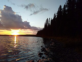
Little Bear Lake is a lake in the boreal forest ecozone in the Canadian province of Saskatchewan. The lake is in a hilly plateau called Cub Hills and the landforms, such as the lakes and streams, of the Cub Hills were formed over 10,000 years ago during the last ice age. Little Bear Lake is accessed from the Hanson Lake Road, which runs along the eastern side of the lake, and by a small airport called Little Bear Lake Airport.

Narrow Hills Provincial Park is a northern boreal forest provincial recreational park in the Canadian province of Saskatchewan. It is located in a hilly plateau called the Cub Hills and contains several recreational facilities and over 25 accessible lakes within its boundaries. The geographical features of the park, including the lakes, valleys, and lowlands were formed over 10,000 years ago during the last ice age. The town of Smeaton is the closest community and it is located 70 kilometres (43 mi) to the south.
Pelican Pointe is a resort village in the Canadian province of Saskatchewan within Census Division No. 6. It is on the shores of Last Mountain Lake in the Rural Municipality of McKillop No. 220.
Moose Mountain Upland, Moose Mountain Uplands, or commonly Moose Mountain, is a hilly plateau located in the south-east corner of the Canadian province of Saskatchewan, that covers an area of about 13,000 km2 (5,000 sq mi). The upland rises about 200 m (660 ft) above the broad, flat prairie which is about 600 m (2,000 ft) above sea level. The highest peak is "Moose Mountain" at 830 m (2,720 ft) above sea level. The area was named Moose Mountain because of the large number of moose that lived in the area. When it was originally used by fur traders, Métis, and the Indigenous peoples, the plateau was called Montagne a la Bosse, which is French for "The Mountain of The Bump or Knob."

Pipestone Creek is a river in the Souris River watershed. Its flow begins in southeastern Saskatchewan, just south of the town of Grenfell and travels in a southeastern direction into Manitoba in the Westman Region where it empties into Oak Lake through the Oak Lake Marsh.

Moose Mountain Creek is a river in the Canadian province of Saskatchewan. Its source is the Chapleau Lakes near Montmartre and it is a tributary of the Souris River, which, in turn, is a tributary of the Assiniboine River. The whole system is part of the Red River watershed, which is part of the Hudson Bay drainage basin and in a region called the Prairie Pothole Region of North America, which extends throughout three Canadian provinces and five U.S. states. It is also within Palliser's Triangle and the Great Plains ecoregion.
Porcupine Hills Provincial Park is the newest provincial park in the Canadian Province of Saskatchewan. It was created in 2018 through the amalgamation of five pre-existing provincial recreation sites south-east of the town of Hudson Bay. The park is in the Porcupine Provincial Forest in the Porcupine Hills, which is a geographical feature in eastern Saskatchewan and western Manitoba. The hills are part of a range of hills called the Manitoba Escarpment.
Last Mountain Creek is a river in south-central Saskatchewan. It is a tributary of the Qu'Appelle River in a region called the Prairie Pothole Region of North America, which extends throughout three Canadian provinces and five U.S. states. It is also within Palliser's Triangle and the Great Plains ecoregion.

Last Mountain House Provincial Park is a provincial park in the Canadian province of Saskatchewan in the RM of Longlaketon. The park is located on the southern end on the eastern shore of Last Mountain Lake, the largest natural lake in southern Saskatchewan.

Lanigan Creek is a river in the Canadian province of Saskatchewan. It is located in the south central part of the province in a region called the Prairie Pothole Region of North America, which extends throughout three Canadian provinces and five U.S. states. It is also within Palliser's Triangle and the Great Plains ecoregion.
Arm River is a river in the Canadian province of Saskatchewan. It is located in the south central part of the province in a region called the Prairie Pothole Region of North America, which extends throughout three Canadian provinces and five U.S. states. It is also within Palliser's Triangle and the Great Plains ecoregion.
Rowan's Ravine Provincial Park is a provincial park in the Canadian province of Saskatchewan. It is on the eastern shore of Last Mountain Lake near a coulee named Rowan's Ravine in the RM of McKillop No. 220. Highway 220 provides access to the park and the town of Strasbourg is about 25 kilometres (16 mi) away. The hamlet of Uhl's Bay is less than a mile away just off of Highway 220.
Pasquia Hills are hills in the Canadian province of Saskatchewan. They are located in the east central part of the province in the RM of Hudson Bay No. 394 near the Manitoba border. The hills are the northern most in a series of hills called the Manitoba Escarpment. The Manitoba Escarpment marks the western edge of the pre-historical glacial Lake Agassiz. The other four hills include Porcupine Hills, Duck Mountain, and Riding Mountain.

Fir River is a river in the Canadian province of Saskatchewan. The river's source is in the east central part of the province in the heart of the Pasquia Hills, which is one of four landforms that make up the Manitoba Escarpment. It flows in a southward direction until it meets up with the Red Deer River south of the town of Hudson Bay in Hudson Bay Regional Park. The river is in the boreal forest. Fir River is in the Nelson River drainage basin.
First Mustus Lake is a lake in Meadow Lake Provincial Park in the Canadian Province of Saskatchewan in the boreal forest ecozone of Canada. The lake is the first of four lakes in a row named Mustus in the Rusty Creek watershed. The other lakes are Second, Third, and Fourth Mustus. Rusty Creek and the lakes are part of the Waterhen River drainage basin. The Waterhen River is a tributary of the Beaver River, which flows north into Lac Île-à-la-Crosse and the Churchill River, a major tributary in the Hudson Bay drainage basin. Highway 224 provides access to both First and Second Mustus Lakes.
Pepaw River, also spelt Peepaw, is a river in the east-central part of the Canadian province of Saskatchewan in the boreal forest ecozone of Canada. It begins in the Porcupine Hills and flows northward and meets up with the Etomami River south of the town of Hudson Bay. Much of the river is within Saskatchewan's Porcupine Provincial Forest and as such has various recreational opportunities along its course.
Piwei River is a river in the east-central part of the Canadian province of Saskatchewan in the boreal forest ecozone of Canada. It begins at the western end of the Porcupine Hills at Piwei Lakes and heads in an easterly direction through a glacier-formed valley and into the Etomami River, which is a tributary of the Red Deer River.
