The former Township of Longford, was surveyed in 1861 by Brookes Wright Gossage, as one of ten townships sold to the Canadian Land and Emigration Company. Longford was the only one of the townships within Victoria County. In 1867 John Thomson purchased by auction the right to cut timber in the township, from the Canadian Land and Emigration Company, to supply timber for his mill at Longford Mills, named for the township. Thomson later purchased the township outright from the Company.
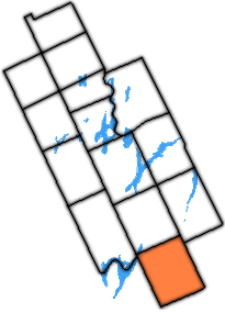
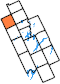
New Longford Township within Kawartha Lakes
The former township should not be confused with the extant Longford Township, a township wholly owned by Longford Reserve Limited, and contains no permanent inhabitants. The extant township is adjacent to the former (populated) township.
The old Digby fire tower was situated on rocky outcropping straight north of the village of Uphill, where the old fire trail used to exist, along the former alignment of the Victoria Rd. The tower was de-commissioned in the late 1960s. The area now is mostly swamp, but can be accessed on a newer private road to the west.
The township is also home to a few ghost settlements from the bygone logging/ farming era of the 19th century. These include: Ragged Rapids and the eastern part of Uphill.
1) This area lies on the border of an adjacent region, but is part of the Kawartha Lakes census.
Related Research Articles
Lindsay is a community of 22,367 people on the Scugog River in the Kawartha Lakes region of south-eastern Ontario, Canada. It is approximately 43 km (27 mi) west of Peterborough. It is the seat of the City of Kawartha Lakes, and the hub for business and commerce in the region.
Coboconk, often shortened to Coby, is a community in the city of Kawartha Lakes, in the south-central portion of the Canadian province of Ontario. The village lies at the junction of Highway 35 and former Highway 48, on the northern tip of Balsam Lake, the highest point on the Trent–Severn Waterway. Coboconk has a prominent role in the logging, limestone, and tourism industries of the Kawartha Lakes region over the past 150 years.
The County of Victoria, or Victoria County, was a county in the Canadian province of Ontario. It was formed in 1854 as The United Counties of Peterborough and Victoria, and separated from Peterborough in 1863. In 2001, the county was dissolved and reformed as the city of Kawartha Lakes. Though first opened to settlement in 1821, the area that was encompassed by Victoria County has a history of Indian occupation, first by the Hurons.
The City of Kawartha Lakes is a unitary municipality in Central Ontario, Canada. It is a municipality legally structured as a single-tier city; however, Kawartha Lakes is the size of a typical Ontario county and is mostly rural. It is the second largest single-tier municipality in Ontario by land area.
Ramara is a lower-tier township municipality in Simcoe County, Ontario, Canada.
Haliburton—Kawartha Lakes—Brock is a federal electoral district in central Ontario, Canada, that has been represented in the House of Commons of Canada since 1968.
Norland is a small rural farming community, from 1854-1967 known as Norland, Victoria, Canada West, British Colonial America, then on the 1 July 1867 it became known as Norland, Laxton Township, Victoria, Ontario, Canada until 1 July 2001 when it was amalgamation to became part of the city of Kawartha Lakes, in the Canadian province of Ontario. It is located in a scenic spot on the Gull River at the north end of Shadow Lake, the northernmost Kawartha lake in the Trent River chain. Here, a series of three waterfalls reflect the change in elevation of the land leading north to the Haliburton Highlands.
Durham County is an historic county in Ontario, Canada. It was named for the English County Durham and city of Durham. It was created in 1792 but was later merged Northumberland County to form the United Counties of Northumberland and Durham. In 1974, the two counties were split and reorganized, with the former portions of Durham County reorganized into the Regional Municipality of Durham.
The United Townships of Dysart, Dudley, Harcourt, Guilford, Harburn, Bruton, Havelock, Eyre and Clyde, commonly known as the Municipality of Dysart et al, is a municipality in Haliburton County in Central Ontario, Canada. The original townships were of the Canadian Land and Emigration Company.
Omemee is a community within the city of Kawartha Lakes, Ontario, Canada, formerly known as Victoria County. Located on Ontario Highway 7, which is the Trans-Canada Highway, Omemee is one of the communities in the Kawartha Lakes, as the proclaimed "city" is vastly rural and has but one major population centre. The community had a population of 1,247 in the Canada 2011 Census. It is located between the city of Peterborough and the community of Lindsay. Lindsay is the largest population centre in the city of Kawartha Lakes, and serves as the administrative centre as it did with Victoria County.
The Township of Bexley was a municipality located in the northern half of the former Victoria County, now the city of Kawartha Lakes, in the Canadian province of Ontario.
The Township of Mariposa was a municipality located in the southwest corner of the former Victoria County, now the city of Kawartha Lakes, in the Canadian province of Ontario. The other municipal neighbours of Mariposa are Ops and Fenelon on the east, Eldon on the north, Brock on the west, and Scugog on the south, with the latter two located in the Durham Regional Municipality. The former township includes the communities of Little Britain, Manilla, Mariposa, Valentia, and Oakwood. Today, most of the former township is represented in the City of Kawartha Lakes by the Ward 8 Councillor, John Pollard, and Ward 4 Councillor Andrew Veale.
The Township of Emily was a municipality located in the south-eastern corner of the former Victoria County, now the city of Kawartha Lakes, in Ontario, Canada.
The Township of Manvers was a municipality in the former Victoria County, now the city of Kawartha Lakes, in the Canadian province of Ontario.
The Township of Dalton was a municipality located in the northwest corner of the former Victoria County, now a geographic township in the city of Kawartha Lakes, in the Canadian province of Ontario. It was named after John Dalton (1766–1844), an English scientist who contributed to the foundations of atomic theory.
The Township of Verulam was a rural municipality within the former Victoria County, now the city of Kawartha Lakes. It was bounded on the north by the geographic township of Somerville, the south by the geographic township of Emily, the west by the geographic township of Fenelon, and the east by the County of Peterborough. For the purposes of government, land surveying and reference, it is now properly referred to as the "Geographic Township of Verulam".
Haliburton—Kawartha Lakes—Brock is a provincial electoral district in Central Ontario, Canada. It elects one member to the Legislative Assembly of Ontario.
St. Mary's was the site of a planned village within early Victoria County, in the Canadian province of Ontario. The site was laid aside in the surveying of the county in the 1830s, but was later found to be unusable when limestone was discovered two inches below the ground. Today its site marks one end of a man-made canal between Balsam Lake and Lake Simcoe, part of the Trent-Severn Waterway.
Kawartha Lakes Road 35, also known as Victoria Road and Fennel Road, is a municipally-maintained road located in the city of Kawartha Lakes, in the Canadian province of Ontario. The road is mostly straight, running in a north–south orientation throughout its length. It began at the hamlet of Glenarm and travels 30.5 kilometres (19.0 mi) to Uphill.
This page is based on this Wikipedia article Text is available under the CC BY-SA 4.0 license; additional terms may apply. Images, videos and audio are available under their respective licenses.