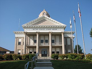
Wythe County is a county located in the southwestern part of the U.S. state of Virginia. As of the 2020 census, the population was 28,290. Its county seat is Wytheville.

Sago is an unincorporated community in Upshur County, West Virginia, United States. It is located along the Buckhannon River and is the site of the Sago Mine, scene of the 2006 Sago Mine disaster.
Melville is an unincorporated community in Logan County, West Virginia, United States. The community of Melville was established in 1967.
Bartley is a census-designated place (CDP) located in McDowell County, West Virginia, United States. It lies along the Norfolk and Western Railroad on the Dry Fork. As of the 2010 census, its population was 224. According to the Geographic Names Information System, Bartley has also been known as Bartlett and Peeryville.

Uneeda is an unincorporated community on the Pond Fork River in Boone County in the U.S. state of West Virginia. The town lies along West Virginia Route 85.
Stotesbury is an unincorporated community and former coal town in Raleigh County in the U.S. state of West Virginia that flourished during the 1930s. The community was named for Edward T. Stotesbury, then the president of Beaver Coal Company.
Bream is an unincorporated community along Indian Creek Rd in Kanawha County, West Virginia, United States. It is the first community after State Route 114 turns across the Elk River to Big Chimney. Bream is located between Milliken and Pinch, and is usually omitted from the map, because of its size.
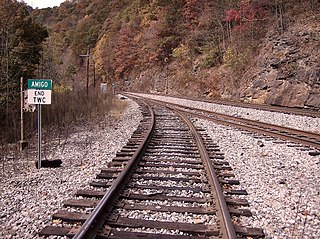
Amigo is an unincorporated community in Raleigh County, West Virginia, United States. The community is located on West Virginia Route 16 at the confluence of the Guyandotte River and Winding Gulf. The Amigo Post Office closed on October 22, 2011; it was established in 1915.

Idamay is a census-designated place (CDP) in Marion County, West Virginia, United States. Idamay is located along West Virginia Route 218, 1 mile (1.6 km) south of Farmington. Idamay has a post office with ZIP code 26576. As of the 2010 census, its population was 611.

Six is an unincorporated community in McDowell County, West Virginia, United States. Six is located on West Virginia Route 16, 5 miles (8.0 km) southwest of Welch.
Summerlee is an unincorporated community and coal town in Fayette County, West Virginia, United States. Summerlee is 2 miles (3.2 km) north-northwest of Oak Hill. The Summerlee Mine was located here and was owned by the New River Coal Company.

Layland is an unincorporated community in Fayette County, West Virginia, United States. Layland is located on West Virginia Route 41, 6.5 miles (10.5 km) west-northwest of Meadow Bridge. Layland has a post office with ZIP code 25864.
Cunard is an unincorporated community in Fayette County, West Virginia, United States. Cunard is 5 miles (8.0 km) southeast of Fayetteville.
Boomer is a census-designated place (CDP) in Fayette County, West Virginia, United States. Boomer is located on the north bank of the Kanawha River, 2 miles (3.2 km) southeast of Smithers. Boomer has a post office with ZIP code 25031. As of the 2010 census, its population was 615.
Mead is an unincorporated community in Raleigh County, West Virginia, United States. Mead is located on County Route 33 and Stonecoal Creek, 2.7 miles (4.3 km) east-northeast of Rhodell. Mead had a post office, which closed on June 10, 1989. It was also known as Vanwood.
Edwight is an unincorporated community in Raleigh County, West Virginia. Edwight was also known as Launa.
Beury is an unincorporated community and coal town in Fayette County, West Virginia, United States.
Nuttallburg was an unincorporated community located in Fayette County, West Virginia, named by English pioneer John Nuttall who discovered coal in the area. Nuttallburg had a post office until 1955. It is no longer inhabited and is just outside Winona.
Olcott is an unincorporated community and coal town in Kanawha County, West Virginia, United States. Its post office is closed.

Wickham is an unincorporated community in Raleigh County, West Virginia, United States. Its post office is closed.


