
Marion County is a county in the U.S. state of West Virginia. As of the 2010 census, the population was 56,418. Its county seat is Fairmont. The county was named in honor of General Francis Marion, known to history as "The Swamp Fox".

Stringtown is a town in Atoka County, Oklahoma, United States. The population was 410 at the 2010 census, an increase of 3.5 percent from 396 at the 2000 census. It is the second largest town in Atoka County.
Stringtown is the name of several places in the U.S. state of West Virginia:

Stringtown is an unincorporated community in Marion County, West Virginia, United States.
Stringtown can refer to the following:
Stringtown is a small, unincorporated community located along the Stringtown Road near Belington in Barbour County, West Virginia. It traces its route from east to west beginning on West Virginia Route 92, until it intersects with Cross Road, which exits back onto WV 92, turns south until it intersects with Laurel Mountain Road. On the way, it also intersects with Hunters Fork Road which travels north and also empties back onto WV 92.
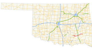
State Highway 43 is a state highway in Oklahoma, United States. It runs 65.3 miles west-to-east through Coal, Atoka, Pushmataha and Pittsburg counties.
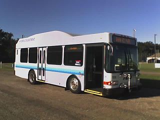
Metropolitan Evansville Transit System (METS) is a public transit system consisting primarily of bus service in the city of Evansville, Indiana.

The Huntington–Ashland metropolitan area is the largest metropolitan statistical area in West Virginia and includes seven counties across three states: West Virginia, Kentucky, and Ohio. New definitions from February 28, 2013 placed the population at 361,580. The MSA is nestled along the banks of the Ohio River within the Appalachian Plateau region. The area is referred to locally as the "Tri-State area". In addition, the three largest cities are referred to as the River Cities.

Center Township is one of twelve townships in Boone County, Indiana. As of the 2010 census, its population was 18,030 and it contained 7,934 housing units. It was named from its location at the geographic center of Boone County.

Maryland Route 121 is a state highway in the U.S. state of Maryland. Known as Clarksburg Road, the highway runs 3.96 miles (6.37 km) from MD 117 in Boyds north to Stringtown Road between Interstate 270 (I-270) and MD 355 in Clarksburg. MD 121 connects Boyds and Clarksburg in northern Montgomery County. The highway was paved from Clarksburg to Boyds in the early to mid-1910s. MD 121 was extended to north of Clarksburg in the late 1920s and early 1930s. MD 121 was relocated through Clarksburg in the mid-1950s when I-270 was constructed through the area. The highway's northern end was rolled back to MD 355 in the mid-1970s. MD 121 was relocated in Boyds in the mid-1980s. The highway's northern end was moved to its present terminus just north of I-270 when Stringtown Road was constructed in the mid-2000s. In addition to the Boyds–Clarksburg route, MD 121 has also included three disjoint segments in Dawsonville and Germantown. All three of these routes were segments of the original MD 119.

Stringtown is an unincorporated community in Cass Township, Sullivan County, in the U.S. state of Indiana.
Tyler Mountain is an unincorporated community in Kanawha County, West Virginia, United States. Tyler Mountain is located at the junction of West Virginia Route 62 and West Virginia Route 501 5.5 miles (8.9 km) west-northwest of Charleston.
Stringtown is an unincorporated community in Roane County, West Virginia, United States. Stringtown is located on County Route 52 9.25 miles (14.89 km) south of Spencer.
Alvy is an unincorporated community in Tyler County, West Virginia, United States. Alvy is located along County Route 13 and Indian Creek, 16 miles (26 km) east-southeast of Middlebourne. Alvy was once Moore, VA changed to Alvy c. 1850 and had a post office, which closed on February 1, 1997; the post office used the name Alvy.

Indian Creek is a tributary of Middle Island Creek, 14.8 miles (23.8 km) long, in northern West Virginia in the United States. Via Middle Island Creek and the Ohio River, it is part of the watershed of the Mississippi River, draining an area of 32.3 square miles (84 km2) in a rural region on the unglaciated portion of the Allegheny Plateau.

Stringtown is an unincorporated community in Center Township, Vanderburgh County, in the U.S. state of Indiana.
Stringtown is an unincorporated community in Washington Township, Ripley County, in the U.S. state of Indiana.
Kentucky Route 292 (KY 292) is a 43.2-mile-long (69.5 km) state highway in the U.S. state of Kentucky. The highway connects mostly rural areas of Pike and Martin counties with South Williamson and Warfield. Nearly the entire highway is located near the West Virginia state line.


