Lindsay, Reeves County, Texas

Last updated

Lindsay, Texas
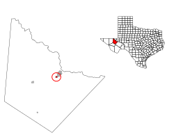
Reeves County Lindsay.svg
Location of Lindsay, Texas
Country United States
State Texas
County Reeves
Area
  Total1.0 sq mi (3 km2)
  Land1.0 sq mi (3 km2)
  Water0.0 sq mi (0 km2)
Population
 (2020)
  Total452
  Density450/sq mi (170/km2)
Time zone UTC-6 (Central (CST))
  Summer (DST) UTC-5 (CDT)

Lindsay is a census-designated place (CDP) in Reeves County, Texas, United States. The population was 452 at the 2020 census.

Contents

Geography

Lindsay is located at 31°22′5″N103°32′12″W / 31.36806°N 103.53667°W / 31.36806; -103.53667 (31.368075, -103.536789). [1]

According to the United States Census Bureau, the CDP has a total area of 1.0 square mile (2.7 km2), all land.

Demographics

Historical population
CensusPop.Note
2000 394
2010 271−31.2%
2020 45266.8%
U.S. Decennial Census [2]
1850–1900 [3] 1910 [4]
1920 [5] 1930 [6] 1940 [7]
1950 [8] 1960 [9] 1970 [10]
1980 [11] 1990 [12] 2000 [13]
2010 [14] 2020 [15]

As of the census [16] of 2000, there were 394 people, 115 households, and 100 families residing in the CDP. The population density was 379.4 inhabitants per square mile (146.5/km2). There were 126 housing units at an average density of 121.3 per square mile (46.8/km2). The racial makeup of the CDP was 87.82% White, 0.25% African American, 0.76% Native American, 3.30% from other races, and 7.87% from two or more races. Hispanic or Latino of any race were 91.62% of the population.

There were 115 households, out of which 46.1% had children under the age of 18 living with them, 74.8% were married couples living together, 8.7% had a female householder with no husband present, and 13.0% were non-families. 12.2% of all households were made up of individuals, and 6.1% had someone living alone who was 65 years of age or older. The average household size was 3.43 and the average family size was 3.78.

In the CDP, the population was spread out, with 35.3% under the age of 18, 9.9% from 18 to 24, 26.1% from 25 to 44, 17.5% from 45 to 64, and 11.2% who were 65 years of age or older. The median age was 29 years. For every 100 females, there were 92.2 males. For every 100 females age 18 and over, there were 93.2 males.

The median income for a household in the CDP was $12,188, and the median income for a family was $18,897. Males had a median income of $23,906 versus $8,229 for females. The per capita income for the CDP was $5,142. About 41.6% of families and 43.0% of the population were below the poverty line, including 41.2% of those under age 18 and 51.1% of those age 65 or over.
Related Research Articles

<span class="mw-page-title-main">Lakehills, Texas</span> CDP in Texas, United States

Lakehills is a census-designated place (CDP) in Bandera County, Texas, United States. The population was 5,295 at the 2020 census, making it the most populous place in Bandera County. It is part of the San Antonio Metropolitan Statistical Area.

<span class="mw-page-title-main">Circle D-KC Estates, Texas</span> CDP in Texas, United States

Circle D-KC Estates is a census-designated place (CDP) in Bastrop County, Texas, United States. The population was 2,588 at the 2020 census.

<span class="mw-page-title-main">Bixby, Texas</span> CDP in Texas, United States

Bixby is a census-designated place (CDP) in Cameron County, Texas, United States. The population was 352 at the 2020 census. It is part of the Brownsville–Harlingen Metropolitan Statistical Area.

<span class="mw-page-title-main">Cameron Park, Texas</span> CDP in Texas, United States

Cameron Park is a census-designated place (CDP) in Cameron County, Texas, United States. The population was 6,099 at the 2020 census. It is part of the Brownsville–Harlingen Metropolitan Statistical Area.

<span class="mw-page-title-main">Del Mar Heights, Texas</span> Census-designated place in Texas, United States

Del Mar Heights is a census-designated place (CDP) in Cameron County, Texas, United States. The population was 78 at the 2020 census. It is part of the Brownsville–Harlingen Metropolitan Statistical Area.

<span class="mw-page-title-main">Green Valley Farms, Texas</span> Census-designated place in Texas, United States

Green Valley Farms is a census-designated place (CDP) in Cameron County, Texas, United States. The population was 655 at the 2020 census, down from 1,272 at the 2010 census. It is part of the Brownsville–Harlingen Metropolitan Statistical Area.

<span class="mw-page-title-main">Ratamosa, Texas</span> Census-designated place in Texas, United States

Ratamosa is a census-designated place (CDP) in Cameron County, Texas, United States. The population was 197 at the 2020 census. It is part of the Brownsville–Harlingen Metropolitan Statistical Area.

Butterfield is a census-designated place (CDP) in El Paso County, Texas, United States. The population was 100 at the 2020 census. It is part of the El Paso Metropolitan Statistical Area. The ZIP Code encompassing the CDP area is 79938.

<span class="mw-page-title-main">Morning Glory, Texas</span> Census-designated place in Texas, United States

Morning Glory is a census-designated place (CDP) in El Paso County, Texas, United States. The population was 522 at the 2020 census, down from 651 at the 2010 census. It is part of the El Paso Metropolitan Statistical Area. The ZIP Code encompassing the CDP area is 79836.

<span class="mw-page-title-main">Pinewood Estates, Texas</span> Census-designated place in Texas, United States

Pinewood Estates is an unincorporated community and census-designated place (CDP) in Hardin County, Texas, United States. The population was 1,641 at the 2020 census. It is part of the Beaumont–Port Arthur Metropolitan Statistical Area.

<span class="mw-page-title-main">Indian Hills, Texas</span> Census-designated place in Texas

Indian Hills is a census-designated place (CDP) in Hidalgo County, Texas, United States. At the 2020 United States Census, the population was 2,694. It is part of the McAllen–Edinburg–Mission Metropolitan Statistical Area.

<span class="mw-page-title-main">Relampago, Texas</span> Census-designated place in Texas

Relampago is a census-designated place (CDP) in Hidalgo County, Texas, United States. The population was 129 at the 2020 United States Census. It is part of the McAllen–Edinburg–Mission Metropolitan Statistical Area.

<span class="mw-page-title-main">Lipscomb, Texas</span> Census-designated place in Texas, United States

Lipscomb is an unincorporated community and census-designated place (CDP) in Lipscomb County, Texas, United States. It is the Lipscomb county seat. The population was 66 at the 2020 census.

<span class="mw-page-title-main">Coyanosa, Texas</span> Village in Texas, United States

Coyanosa is an unincorporated desert village in Pecos County, located in the Permian Basin in West Texas, United States. Its population was 155 at the 2020 census. Part of the Coyanosa Draw runs adjacent to the town, 2.2 miles to the west. There is a food store, two Mexican restaurants, a public library, an RV park and a post office at Coyanosa by way of businesses and services.

<span class="mw-page-title-main">Redford, Texas</span> CDP in Texas, United States

Redford is a census-designated place (CDP) in Presidio County, Texas, United States. The population was 43 at the 2020 census.

<span class="mw-page-title-main">El Refugio, Texas</span> CDP in Texas, United States

El Refugio is a census-designated place (CDP) in Starr County, Texas, United States. The population was 407 at the 2020 census. El Refugio gained area in the 2010 census.

<span class="mw-page-title-main">Garceno, Texas</span> CDP in Texas, United States

Garceno is a census-designated place (CDP) in Starr County, Texas, United States. The population was 440 at the 2020 census, an increase from the figure of 420 tabulated in 2010.

<span class="mw-page-title-main">La Victoria, Texas</span> CDP in Texas, United States

La Victoria is a census-designated place (CDP) in Starr County, Texas, United States. La Victoria underwent some changes prior to the 2010 census. It gained area, had portions taken to form new CDPs, and lost additional area. Only a small part of 2010 La Victoria CDP was within the 2000 La Victoria CDP. The population was only 171 at the 2010 census, a decline from the figure of 1,683 tabulated at the 2000 census.

<span class="mw-page-title-main">North Escobares, Texas</span> CDP in Texas, United States

North Escobares is a census-designated place (CDP) in Starr County, Texas, United States. The population was 118 at the 2010 census, a decline from the figure of 1,692 tablulated in 2000.

<span class="mw-page-title-main">Botines, Texas</span> CDP in Texas, United States

Botines is a census-designated place (CDP) in Webb County, Texas, United States. The population was 149 at the 2020 census. Botines is located 5 miles (8.0 km) north of Laredo. The town's name originates from the Spanish term botín, which means buskin, boot, or legging.

References

  1. "US Gazetteer files: 2010, 2000, and 1990". United States Census Bureau. February 12, 2011. Retrieved April 23, 2011.
  2. "Decennial Census by Decade". United States Census Bureau .
  3. "1900 Census of Population - Population of Texas By Counties And Minor Civil Divisions" (PDF). United States Census Bureau .
  4. "1910 Census of Population - Supplement for Texas" (PDF). United States Census Bureau .
  5. "1920 Census of Population - Number of Inhabitants - Texas" (PDF). United States Census Bureau .
  6. "1930 Census of Population - Number of Inhabitants - Texas" (PDF). United States Census Bureau .
  7. "1940 Census of Population - Number of Inhabitants - Texas" (PDF). United States Census Bureau .
  8. "1950 Census of Population - Number of Inhabitants - Texas" (PDF). United States Census Bureau .
  9. "1960 Census of Population - Number of Inhabitants - Texas" (PDF). United States Census Bureau .
  10. "1970 Census of Population - Number of Inhabitants - Texas" (PDF). United States Census Bureau .
  11. "1980 Census of Population - Number of Inhabitants - Texas" (PDF). United States Census Bureau .
  12. "1990 Census of Population - Population and Housing Unit Counts - Texas" (PDF). United States Census Bureau .
  13. "2000 Census of Population - Population and Housing Unit Counts - Texas" (PDF). United States Census Bureau .
  14. "2010 Census of Population - Population and Housing Unit Counts - Texas" (PDF). United States Census Bureau .
  15. "Census Bureau profile: Lindsay, Texas". United States Census Bureau. May 2023. Retrieved June 11, 2024.
  16. "U.S. Census website". United States Census Bureau . Retrieved January 31, 2008.