List of Canadian provinces and territories by historical population

Last updated

This is a list of Canadian historical population by province and territory, drawn from the Canadian census of population data and pre-Confederation censuses of Newfoundland and Labrador. Since 1871, Canada has conducted regular national census counts. The data for 1851 to 1976 is drawn primarily from Historical Statistics of Canada, 2nd edition. [1] Data for 1981 through 2021 are from the respective year's respective census. Newfoundland and Labrador pre-Confederation data is from the 1945 Census of Newfoundland and Labrador, volume 1. [2] Data for 1841 and some 1851 data drawn from the 1931 Canadian census. [3] With the exception of Nunavut prior to 1996, the population figures largely reflect modern provincial boundaries; prior to 1996, the population of modern Nunavut is reported with Northwest Territories. Although the census has worked to count First Nations populations since 1871, the it is likely Indigenous Canadians are undercounted by the census. [4] Shaded blocks indicate periods before the province or territory joined the Canadian Confederation. Instances where the reported figure came from a different year's population count (primarily pre-1861 and for Newfoundland) are noted. Total Canadian population row includes the population of Newfoundland and Labrador.

Contents

1700 to 1825

Estimates from The Canada Year Book (1867) based on various provincial census records. [5]

Name170017251750177518001825
Civil Ensign of the United Kingdom.svg  Lower Canada 14,00029,00054,50096,000225,000450,000
Flag of Nova Scotia (1868-1929).png New Brunswick [lower-alpha 1]     10,00075,000
Flag of Newfoundland (1862-1870).svg Newfoundland 5005,00010,00016,00010,00045,759
Flag of Nova Scotia (1868-1929).png  Nova Scotia [lower-alpha 2] 1,3005,00014,00020,00057,000150,000
Flag of Nova Scotia (1868-1929).png Prince Edward Island [lower-alpha 3]  3002,50010,00020,00028,600
Civil Ensign of the United Kingdom.svg  Upper Canada    8,00050,000158,027
Total15,80039,30081,000150,000382,000907,386

1841 to 1931

NameConfederated [lower-alpha 4] 1841185118611871 [lower-alpha 5] 188118911901191119211931
Flag of Alberta.svg  Alberta 1905     25,277 [lower-alpha 6] 73,022374,295588,454731,605
Flag of British Columbia.svg  British Columbia 187162,10055,00051,52436,24749,45998,173178,657392,480524,582694,263
Flag of Manitoba.svg  Manitoba 18704,704 [lower-alpha 7] 5,391 [lower-alpha 8] 25,22862,260152,506255,211461,394610,118700,139
Flag of New Brunswick.svg  New Brunswick 1867156,162 [lower-alpha 9] 193,800252,047285,594321,233321,263331,120351,889387,876408,219
Flag of Newfoundland and Labrador.svg  Newfoundland and Labrador [lower-alpha 10] 194996,296 [lower-alpha 11] 101,600124,288 [lower-alpha 12] 146,536 [lower-alpha 13] 197,335 [lower-alpha 14] 202,040 [lower-alpha 15] 220,984 [lower-alpha 16] 242,619 [lower-alpha 17] 263,033 [lower-alpha 18] 289,588 [lower-alpha 19]
Flag of the Northwest Territories.svg  Northwest Territories 1870 5,7006,69148,00056,44662,54020,1296,5078,1439,316
Flag of Nova Scotia.svg  Nova Scotia 1867202,575 [lower-alpha 20] 276,854330,857387,800440,572450,396459,574492,338523,837512,846
Flag of Nunavut.svg  Nunavut [lower-alpha 21] 1999          
Flag of Ontario.svg  Ontario 1867466,831 [lower-alpha 22] 952,004 [lower-alpha 23] 1,396,091 [lower-alpha 23] 1,620,8511,926,9222,114,3212,182,9472,527,2922,933,6623,431,683
Flag of Prince Edward Island.svg  Prince Edward Island 187347,04262,678 [lower-alpha 24] 80,85794,021108,891109,078103,25993,72888,61588,038
Flag of Quebec.svg  Quebec 1867716,670 [lower-alpha 25] 890,261 [lower-alpha 26] 1,111,566 [lower-alpha 26] 1,191,5161,359,0271,488,5351,648,8982,005,7762,360,5102,874,662
Flag of Saskatchewan.svg  Saskatchewan 1905     11,150 [lower-alpha 6] 91,279492,432757,510921,785
Flag of Yukon.svg  Yukon 1898      27,2198,5124,1574,230
Flag of Canada (Pantone).svg  Canada [lower-alpha 27]  1,752,3802,543,2883,353,9213,835,7934,522,1455,035,2795,592,2997,449,2628,787,94910,666,374

1941 to 1991

Name1941195119561961196619711976198119861991
Flag of Alberta.svg  Alberta 796,169939,5011,123,1161,331,9441,463,2031,627,8741,838,0372,213,6502,365,8252,545,553
Flag of British Columbia.svg  British Columbia 817,8611,165,2101,398,4641,629,0821,873,6742,184,6212,466,6082,713,6152,883,3673,282,061
Flag of Manitoba.svg  Manitoba 729,744776,541850,040921,686963,066988,2471,021,5061,013,7051,063,0161,091,942
Flag of New Brunswick.svg  New Brunswick 457,401515,697554,616597,936616,788634,557677,250689,375709,442723,900
Flag of Newfoundland and Labrador.svg  Newfoundland and Labrador [lower-alpha 10] 316,294 [lower-alpha 28] 361,416415,074457,853493,396522,104557,725563,750568,349568,474
Flag of the Northwest Territories.svg  Northwest Territories 12,02816,00419,31322,99828,73834,80742,60945,54052,23857,649
Flag of Nova Scotia.svg  Nova Scotia 577,962642,584694,717737,007756,039788,960828,571839,805873,176899,942
Flag of Nunavut.svg  Nunavut [lower-alpha 21]           
Flag of Ontario.svg  Ontario 3,787,6554,597,5425,404,9336,236,0926,960,8707,703,1068,264,4658,534,2659,101,69410,084,885
Flag of Prince Edward Island.svg  Prince Edward Island 95,04798,42999,285104,629108,535111,641118,229121,225126,646129,765
Flag of Quebec.svg  Quebec 3,331,8824,055,6814,628,3785,259,2115,780,8456,027,7646,234,4456,369,0656,532,4616,895,963
Flag of Saskatchewan.svg  Saskatchewan 895,992831,728880,665925,181955,344926,242921,323956,4401,009,613988,928
Flag of Yukon.svg  Yukon 4,9149,09612,19014,62814,38218,38821,83623,07523,50427,797
Flag of Canada (Pantone).svg  Canada 11,828,474 [lower-alpha 27] 14,009,42916,080,79118,238,24720,014,88021,568,31122,992,60424,083,51025,309,33127,296,859

1996 to 2021

Name199620012006201120162021
Flag of Alberta.svg  Alberta 2,696,8262,974,8073,290,3503,645,2574,067,1754,262,635
Flag of British Columbia.svg  British Columbia 3,724,5003,907,7384,113,4874,400,0574,648,0555,000,879
Flag of Manitoba.svg  Manitoba 1,113,8981,119,5831,148,4011,208,2681,278,3651,342,153
Flag of New Brunswick.svg  New Brunswick 738,133729,498729,997751,171747,101775,610
Flag of Newfoundland and Labrador.svg  Newfoundland and Labrador [lower-alpha 10] 551,792512,930505,469514,536519,716510,550
Flag of the Northwest Territories.svg  Northwest Territories 39,67237,36041,46441,46241,78641,070
Flag of Nova Scotia.svg  Nova Scotia 909,282908,007913,462921,727923,598969,383
Flag of Nunavut.svg  Nunavut 24,73026,74529,47431,90635,94436,858
Flag of Ontario.svg  Ontario 10,753,57311,410,04612,160,28212,851,82113,448,49414,223,942
Flag of Prince Edward Island.svg  Prince Edward Island 134,557135,294135,851140,204142,907154,331
Flag of Quebec.svg  Quebec 7,138,7957,237,4797,546,1317,903,0018,164,3618,501,833
Flag of Saskatchewan.svg  Saskatchewan 990,237978,933968,1571,033,3811,098,3521,132,505
Flag of Yukon.svg  Yukon 30,76628,67430,37233,89735,87440,232
Flag of Canada (Pantone).svg  Canada 28,846,76130,007,09431,612,89733,476,68835,151,72836,991,981

Notes

  1. Split from Nova Scotia in 1784.
  2. Includes population of the Colony of Cape Breton (1784–1820)
  3. Split from Nova Scotia in 1769.
  4. Dates for when the province or territory entered the Canadian Confederation.
  5. First national census, as required in the British North America Act of 1867.
  6. 1 2 Extracted from Northwest Territories enumeration.
  7. Assiniboine and Red River, 1840
  8. Assiniboine and Red River, 1849
  9. 1840
  10. 1 2 3 Originally Newfoundland Colony and from 1907–1949 Dominion of Newfoundland
  11. 1845
  12. 1857: 122,638 in Newfoundland; 1,650 in Labrador
  13. 1869: 144,286 in Newfoundland; 2,150 in Labrador
  14. 1884: 193,124 in Newfoundland; 4,211 in Labrador
  15. 197,934 in Newfoundland; 4,106 in Labrador
  16. 217,037 in Newfoundland; 3,947 in Labrador
  17. 238,670 in Newfoundland; 2,949 in Labrador
  18. 259,259 in Newfoundland; 3,774 in Labrador
  19. 1935: 284,872 in Newfoundland; 4,716 in Labrador
  20. 1838
  21. 1 2 Included in count for Northwest Territories
  22. Upper Canada
  23. 1 2 Canada West
  24. 1849
  25. Lower Canada
  26. 1 2 Canada East
  27. 1 2 Includes population of Newfoundland and Labrador prior to confederation
  28. 1945: 316,294 in Newfoundland; 5,525 in Labrador

Related Research Articles

<span class="mw-page-title-main">Provinces and territories of Canada</span> Top-level subdivisions of Canada

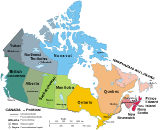
Canada has ten provinces and three territories that are sub-national administrative divisions under the jurisdiction of the Canadian Constitution. In the 1867 Canadian Confederation, three provinces of British North America—New Brunswick, Nova Scotia, and the Province of Canada —united to form a federation, becoming a fully independent country over the next century. Over its history, Canada's international borders have changed several times as it has added territories and provinces, making it the world's second-largest country by area.

<span class="mw-page-title-main">Population of Canada by province and territory</span> Population of Canada by province and territory

Canada is divided into 10 provinces and three territories. The majority of Canada's population is concentrated in the areas close to the Canada–US border. Its four largest provinces by area are also its most populous; together they account for 86.5% of the country's population. The territories account for over a third of Canada's area but are home to only 0.32% of its population, which skews the national population density value.

Statistics Canada, formed in 1971, is the agency of the Government of Canada commissioned with producing statistics to help better understand Canada, its population, resources, economy, society, and culture. It is headquartered in Ottawa.

<span class="mw-page-title-main">Population of Canada</span> Overview of the population of Canada

Canada ranks 37th by population, comprising about 0.5% of the world's total, with over 39 million Canadians as of 2022. Being, however, the fourth-largest country by land area, the vast majority of the country is sparsely inhabited, with most of its population south of the 55th parallel north and just over 60 percent of Canadians live in just two provinces: Ontario and Quebec. Though Canada's population density is low, many regions in the south, such as the Quebec City–Windsor Corridor, have population densities higher than several European countries. Canada's largest population centres are Toronto, Montreal, Vancouver, Calgary, Edmonton and Ottawa, with those six being the only ones with more than one million people.

<span class="mw-page-title-main">Languages of Canada</span>

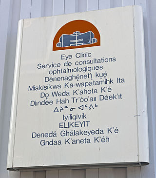
A multitude of languages have always been spoken in Canada. Prior to Confederation, the territories that would become Canada were home to over 70 distinct languages across 12 or so language families. Today, a majority of those indigenous languages are still spoken; however, most are endangered and only about 0.6% of the Canadian population report an Indigenous language as their mother tongue. Since the establishment of the Canadian state, English and French have been the co-official languages and are, by far, the most-spoken languages in the country.

<span class="mw-page-title-main">Channel-Port aux Basques</span> Town in Newfoundland and Labrador, Canada

Channel-Port aux Basques is a town at the extreme southwestern tip of Newfoundland fronting on the western end of the Cabot Strait. A Marine Atlantic ferry terminal is located in the town which is the primary entry point onto the island of Newfoundland and the western terminus of the Newfoundland and Labrador Route 1 in the province. The town was incorporated in 1945 and its population in the 2021 census was 3,547.

<span class="mw-page-title-main">District of Ungava</span>

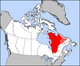
The District of Ungava was a regional administrative district of Canada's Northwest Territories from 1895 to 1920, although it effectively ceased operation in 1912. It covered the northern portion of what is today Quebec, the interior of Labrador, and the offshore islands to the west and north of Quebec, which are now part of Nunavut.

Canadian Senate divisions refers to two aspects of the Senate of Canada. First, it refers to the division of Canada into four regional Senate divisions of 24 senators each, as set out in section 22 of the Constitution Act, 1867. The four regions are the Western Provinces, Ontario, Quebec and the Maritimes. These regions are intended to serve the Senate's purpose of providing regional representation in the Parliament of Canada, in contrast to the popular representation that the House of Commons is intended to provide. While not within any of the original four Senate divisions, Senate seats are also allocated to Newfoundland and Labrador and the three territories. The four divisions can be expanded when the need arises to have an extra two senators appointed to each regional division.

Statistics Canada conducts a national census of population and census of agriculture every five years and releases the data with a two-year lag.

Virgin Arm–Carter's Cove is a local service district and designated place on New World Island in the Canadian province of Newfoundland and Labrador. Virgin Arm-Carter's Cove is located approximately 90 km Northwest of Gander in Subdivision H of Division No. 8.

The timeline of elections in Canada covers all the provincial, territorial and federal elections from when each province was joined Confederation through to the present day. The table below indicates which party won the election. Several provinces held elections before joining Canada, but only their post-Confederation elections are shown. These include:

<span class="mw-page-title-main">Demographics of Newfoundland and Labrador</span>

Newfoundland and Labrador is a province of Canada on the country's Atlantic coast in northeastern North America. The province has an area of 405,212 square kilometres and a population in 2023 of 531,948, with approximately 95% of the provincial population residing on the Island of Newfoundland, with nearly half of the population residing on the Avalon Peninsula. People from Newfoundland and Labrador are called "Newfoundlanders," "Labradorians", or "Newfoundlanders and Labradorians".

The Northwest Territories is a territory of Canada. It has an area of 1,171,918 square kilometres and a population of 41,786 as of the 2016 Census.

<span class="mw-page-title-main">Wabana, Newfoundland and Labrador</span> Town in Newfoundland and Labrador, Canada

Wabana is a Canadian town and the largest, and only incorporated, community on Bell Island in the province of Newfoundland and Labrador.

<span class="mw-page-title-main">Outline of Canada</span> Overview of and topical guide to Canada

The following outline is provided as an overview of and topical guide to Canada:

<span class="mw-page-title-main">Bibliography of Canadian provinces and territories</span>

This is a bibliography of works on the Provinces and territories of Canada.

<span class="mw-page-title-main">South Dildo</span> Local service district / designated place in Newfoundland and Labrador, Canada

South Dildo is a local service district and designated place in the Canadian province of Newfoundland and Labrador.

References

  1. Basavarajappa, K.G.; Ram, Bali (1983). "Section A: Population and Migration" (PDF). Historical Statistics of Canada (2nd ed.). Ottawa, Ontario: Statistics Canada. Retrieved February 13, 2022.
  2. Census of Newfoundland and Labrador, 1945. Vol. 1. Ottawa, Ontario: Dominion Bureau of Statistics. 1945. Retrieved February 13, 2022.
  3. Seventh Census of Canada, 1931 (PDF). Vol. 1. Ottawa, Canada: Dominion Bureau of Statistics. 1931. Retrieved February 13, 2022.
  4. Guimond, Eric; Kerr, Don; Beaujot, Roderic (2003). Charting the Growth of Canada's Aboriginal Populations: Problems, Options and Implications (Technical report). PSC Discussion Papers. Vol. 17. 5. Retrieved February 13, 2022.
  5. "Canada Year Book (CYB) Historical Collection: Progress of Population, 1700 to 1825". www65.statcan.gc.ca. Statistics Canada. March 31, 2008. Retrieved May 10, 2022.