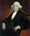
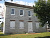
Marker title Image Date dedicated Location Marker type Topics Bethel A.M.E. Church May 9, 2009 131 E Pomfret St., Carlisle City African American, Religion, Underground Railroad Big Spring Presbyterian Church August 18, 1985 S. Corporation St. at church, Newville 40°10′22″N 77°23′50″W / 40.17272°N 77.39736°W / 40.17272; -77.39736 (Big Spring Presbyterian Church ) Roadside Religion Blaine House December 6, 1949 S. Hanover St. between Pomfret & High Sts., Carlisle 40°12′03″N 77°11′21″W / 40.20075°N 77.18907°W / 40.20075; -77.18907 (Blaine House ) City American Revolution, George Washington, Military, Whiskey Rebellion Braddock Expedition November 3, 1961 US 11 (W. King St.), Shippensburg 40°02′53″N 77°31′36″W / 40.04797°N 77.52655°W / 40.04797; -77.52655 (Braddock Expedition ) Roadside French & Indian War, Military Carlisle July 30, 1947 Near Walnut Bottom Rd. & Washington St. intersection, at Thornwall Park entrance, Carlisle 40°11′37″N 77°11′53″W / 40.19357°N 77.19817°W / 40.19357; -77.19817 (Carlisle ) Roadside Cities & Towns, Early Settlement, Military, Whiskey Rebellion Carlisle July 30, 1947 US 11N, east of Carlisle 40°12′41″N 77°10′51″W / 40.21144°N 77.18074°W / 40.21144; -77.18074 (Carlisle ) Roadside American Revolution, Cities & Towns, Early Settlement, Government & Politics, Whiskey Rebellion Carlisle July 30, 1947 U.S. 11 W of Carlisle 40°12′06″N 77°12′42″W / 40.20167°N 77.21158°W / 40.20167; -77.21158 (Carlisle ) Roadside American Revolution, Cities & Towns, Government & Politics, Whiskey Rebellion Carlisle July 30, 1947 PA 34 S of Carlisle, between Noble Blvd. & W Ridge St. 40°11′32″N 77°11′25″W / 40.19227°N 77.19037°W / 40.19227; -77.19037 (Carlisle ) Roadside American Revolution, Cities & Towns, Government & Politics, Whiskey Rebellion Carlisle July 30, 1947 PA 34 N of Carlisle, at PA Turnpike overpass 40°13′13″N 77°11′12″W / 40.22017°N 77.18666°W / 40.22017; -77.18666 (Carlisle ) Roadside Cities & Towns Carlisle Barracks n/a U.S. 11 opposite War College, NE end Carlisle 40°12′45″N 77°10′43″W / 40.21258°N 77.17875°W / 40.21258; -77.17875 (Carlisle Barracks ) Roadside American Revolution, Military, Native American Carlisle Fort November 3, 1961 W. High St. between Pitt & Hanover Sts., Carlisle 40°12′06″N 77°11′27″W / 40.20156°N 77.19075°W / 40.20156; -77.19075 (Carlisle Fort ) City American Revolution, Military Carlisle Indian Industrial School August 31, 2003 North side of Claremont Road, 50 feet East of the Carlisle Barracks entrance 40°12′27″N 77°10′15″W / 40.20754°N 77.17075°W / 40.20754; -77.17075 (Carlisle Indian Industrial School ) Roadside Education, Native American Carlisle Iron Works August 4, 1947 PA 174 just E of Boiling Springs 40°09′02″N 77°07′28″W / 40.15061°N 77.12449°W / 40.15061; -77.12449 (Carlisle Iron Works ) Roadside Business & Industry, Coal, Furnaces, Iron Charles Albert "Chief" Bender October 17, 2003 Indian Field, Carlisle Barracks, off U.S. 11, Carlisle 40°12′33″N 77°10′31″W / 40.20907°N 77.17532°W / 40.20907; -77.17532 (Charles Albert "Chief" Bender ) Roadside Baseball, Education, Native American, Sports Cumberland County May 17, 1982 Old Courthouse, High & Hanover Sts., Carlisle 40°12′05″N 77°11′22″W / 40.20129°N 77.1894°W / 40.20129; -77.1894 (Cumberland County ) City Government & Politics, Government & Politics 18th Century, Roads, Transportation Cumberland Riflemen May 25, 1948 At park, Market St. between 24th & 25th Sts., Camp Hill 40°14′28″N 76°55′31″W / 40.24099°N 76.9254°W / 40.24099; -76.9254 (Cumberland Riflemen ) Roadside American Revolution, Military Cumberland Valley Railroad May 1, 1992 4 Strawberry Alley, Mechanicsburg 40°12′50″N 77°00′31″W / 40.21377°N 77.00872°W / 40.21377; -77.00872 (Cumberland Valley Railroad ) Roadside Railroads, Transportation Daniel Drawbaugh May 1, 1965 155 Lake Rd. (SR 2033) at Eberly's Mill, 1 mile W of New Cumberland 40°13′27″N 76°54′25″W / 40.22423°N 76.90683°W / 40.22423; -76.90683 (Daniel Drawbaugh ) Roadside Business & Industry, Invention, Professions & Vocations Daniel Kaufman May 25, 2002 301 Front Street, Boiling Springs 40°08′18″N 77°07′38″W / 40.1384°N 77.12717°W / 40.1384; -77.12717 (Daniel Kaufman ) Roadside African American, Early Settlement, Underground Railroad Dickinson College July 1, 1947 W High St., near 74N intersection at campus, Carlisle 40°12′08″N 77°11′44″W / 40.20223°N 77.19549°W / 40.20223; -77.19549 (Dickinson College ) Roadside Education Dickinson School of Law October 20, 1949 S. College St. near South St. at Law School, Carlisle 40°11′58″N 77°11′49″W / 40.19933°N 77.19696°W / 40.19933; -77.19696 (Dickinson School of Law ) City Education Episcopal Square October 20, 1949 NE corner, High & Hanover Sts., Carlisle 40°12′06″N 77°11′20″W / 40.20161°N 77.18888°W / 40.20161; -77.18888 (Episcopal Square ) City Government & Politics 18th Century, Religion Farthest North of Confederates - PLAQUE October 1929 PA 34 (E side), .7 mile N of Carlisle Springs Plaque Civil War, Military First Presbyterian Church October 21, 1949 NW corner, High & Hanover Sts., Carlisle 40°12′06″N 77°11′21″W / 40.20172°N 77.18926°W / 40.20172; -77.18926 (First Presbyterian Church ) City Buildings, George Washington, Religion Forbes Road (Raystown Path) January 7, 1952 US 11 just W of Carlisle 40°12′05″N 77°12′44″W / 40.20144°N 77.21228°W / 40.20144; -77.21228 (Forbes Road -Raystown Path ) Roadside French & Indian War, Military, Roads, Transportation Forbes Road (Raystown Path) January 7, 1952 US 11, 1 mile NE of Shippensburg 40°04′16″N 77°29′24″W / 40.07105°N 77.49013°W / 40.07105; -77.49013 (Forbes Road -Raystown Path ) Roadside French & Indian War, Military, Roads, Transportation Fort Couch August 10, 1947 8th & Ohio Sts., Lemoyne 40°14′46″N 76°54′15″W / 40.24607°N 76.90425°W / 40.24607; -76.90425 (Fort Couch ) Roadside Civil War, Forts, Military Fort Couch October 13, 1953 Indiana Ave., betw. 8th St. & West Park, Lemoyne 40°14′48″N 76°54′17″W / 40.24669°N 76.90478°W / 40.24669; -76.90478 (Fort Couch ) City Civil War, Forts, Military Fort Franklin n/a U.S. 11 in Shippensburg (MISSING) Roadside Early Settlement, Forts, French & Indian War, Military, Native American Fort Morris November 3, 1961 King (US 11) & Queen Sts., Shippensburg 40°03′16″N 77°30′54″W / 40.0545°N 77.51511°W / 40.0545; -77.51511 (Fort Morris ) Roadside Forts, French & Indian War, Military Fort Morris - PLAQUE October 1, 1921 N side of W King St. (US 11), betw. Spring & Morris, Shippensburg 40°03′16″N 77°30′54″W / 40.0545°N 77.51511°W / 40.0545; -77.51511 (Fort Morris - PLAQUE ) Plaque Forts, French & Indian War, Military, Native American Frederick Watts June 11, 1994 Ritner Hwy. (US 11) & Shearer Dr. at entrance to Watts Bus. Park, W of Carlisle 40°11′34″N 77°14′11″W / 40.19287°N 77.23634°W / 40.19287; -77.23634 (Frederick Watts ) Roadside Agriculture, Education, Environment, Government & Politics, Professions & Vocations Gen. John Armstrong November 30, 1949 NE corner, High & Bedford Sts., Carlisle 40°12′04″N 77°11′11″W / 40.20111°N 77.18647°W / 40.20111; -77.18647 (Gen. John Armstrong ) City American Revolution, Government & Politics, Military Gen. William Irvine November 30, 1949 SE corner, High & Bedford Sts., Carlisle 40°12′04″N 77°11′12″W / 40.201123°N 77.18657°W / 40.201123; -77.18657 (Gen. William Irvine ) City American Revolution, Government & Politics 18th Century, Medicine & Science, Military, Professions & Vocations George Washington October 20, 1949 W High & West Sts., Carlisle 40°12′07″N 77°11′36″W / 40.20186°N 77.19345°W / 40.20186; -77.19345 (George Washington ) City American Revolution, George Washington, Military, Whiskey Rebellion Gettysburg Campaign April 25, 2001 5115 East Trindle Road, Mechanicsburg 40°13′26″N 76°58′32″W / 40.22389°N 76.97544°W / 40.22389; -76.97544 (Gettysburg Campaign ) Roadside Civil War, Military Gettysburg Campaign June 21, 1997 5002 Carlisle Pike, Hampden Township(@ Ye Olde Ale House) 40°14′24″N 76°55′57″W / 40.23997°N 76.93239°W / 40.23997; -76.93239 (Gettysburg Campaign ) Roadside Civil War, Military Gettysburg Campaign July 29, 1947 PA 74 just E of Carlisle near I-81 40°11′43″N 77°10′04″W / 40.19517°N 77.1679°W / 40.19517; -77.1679 (Gettysburg Campaign ) Roadside Civil War, Military Gettysburg Campaign July 29, 1949 PA 34, .3 mile S of Carlisle near I-81 40°10′43″N 77°11′25″W / 40.17874°N 77.19034°W / 40.17874; -77.19034 (Gettysburg Campaign ) Roadside Civil War, Military Gettysburg Campaign July 29, 1947 Walnut Bottom Rd. (SR 3023), .5 mile SW of Carlisle near I-81 40°11′18″N 77°12′18″W / 40.18822°N 77.20499°W / 40.18822; -77.20499 (Gettysburg Campaign ) Roadside Civil War, Military Gettysburg Campaign June 28, 1963 3025 Market St., Camp Hill 40°14′24″N 76°55′57″W / 40.23997°N 76.93239°W / 40.23997; -76.93239 (Gettysburg Campaign ) Roadside Civil War, Military Green Tree Inn November 30, 1949 S. Hanover St. between Pomfret & High Sts., Carlisle 40°12′03″N 77°11′22″W / 40.20086°N 77.18943°W / 40.20086; -77.18943 (Green Tree Inn ) City Business & Industry, George Washington, Native American, Inns & Taverns Harrisburg August 1, 1947 Front St., at Market St., Wormleysburg 40°15′11″N 76°53′45″W / 40.253067°N 76.89576°W / 40.253067; -76.89576 (Harrisburg ) Roadside Cities & Towns, Early Settlement, Government & Politics Henszey's Wrought Iron Arch Bridge November 22, 2004 Valley Road on edge of campus of Central Pennsylvania College, Enola 40°18′20″N 76°56′00″W / 40.30543°N 76.9334°W / 40.30543; -76.9334 (Henszey's Wrought Iron Arch Bridge ) Roadside Bridges, Business & Industry, Iron, Transportation Irving Female College September 29, 1954 E. Main St. (Pa. 641) near Filbert St., Mechanicsburg 40°12′56″N 76°59′59″W / 40.21547°N 76.99963°W / 40.21547; -76.99963 (Irving Female College ) City Education, Women James Wilson October 20, 1949 SW corner, High & Pitt Sts., Carlisle 40°12′05″N 77°11′31″W / 40.20141°N 77.19194°W / 40.20141; -77.19194 (James Wilson ) City Government & Politics, Government & Politics 18th Century, Professions & Vocations John Bannister Gibson November 30, 1949 E. High St. between Hanover & Bedford Sts., Carlisle 40°12′05″N 77°11′17″W / 40.20141°N 77.18794°W / 40.20141; -77.18794 (John Bannister Gibson ) City Government & Politics, Government & Politics 19th Century, Professions & Vocations, Writers John W. Geary (1819-1873) June 10, 1995 3rd & Bridge Sts., New Cumberland 40°13′32″N 76°51′50″W / 40.22568°N 76.86383°W / 40.22568; -76.86383 (John W. Geary ) City Civil War, Government & Politics, Government & Politics 19th Century, Governors, Military Joseph Ritner October 11, 1951 US 11, 6 miles SW of Carlisle 40°09′36″N 77°19′11″W / 40.16003°N 77.31985°W / 40.16003; -77.31985 (Joseph Ritner ) Roadside Education, Government & Politics, Government & Politics 19th Century, Governors Laughlin Mill July 29, 1947 PA 641 at E end of Newville 40°10′29″N 77°23′30″W / 40.17476°N 77.39155°W / 40.17476; -77.39155 (Laughlin Mill ) Roadside Buildings, Business & Industry, Mills Locust Grove Cemetery May 28, 2007 100 block of N Queen St., Shippensburg Roadside African American, Civil War, Military Major Andre December 6, 1949 S. Hanover St. between South & Pomfret Sts., Carlisle 40°11′57″N 77°11′22″W / 40.19918°N 77.1894°W / 40.19918; -77.1894 (Major Andre ) City American Revolution, Military Marcus A. Reno September 9, 2001 3rd & Reno Sts., New Cumberland 40°13′31″N 76°51′55″W / 40.22526°N 76.86534°W / 40.22526; -76.86534 (Marcus A. Reno ) City Civil War, Military Marianne Moore (1887-1972) April 25, 2002 343 N Hanover Street, Carlisle 40°12′22″N 77°11′15″W / 40.20614°N 77.18754°W / 40.20614; -77.18754 (Marianne Moore ) City Education, Women, Writers Middle Spring Church November 6, 1950 SR 4001 (old PA 696), 2.6 miles N of Shippensburg 40°04′54″N 77°32′28″W / 40.08162°N 77.54112°W / 40.08162; -77.54112 (Middle Spring Church ) Roadside Buildings, Ethnic & Immigration, Religion Molly Pitcher November 30, 1949 S. Hanover St. between Walnut & South Sts., Carlisle 40°11′51″N 77°11′22″W / 40.19762°N 77.18935°W / 40.19762; -77.18935 (Molly Pitcher ) City American Revolution, Military, Women Old Court House November 18, 1947 E King St. (US 11) & Queen St., Shippensburg 40°05′04″N 77°30′47″W / 40.08456°N 77.51296°W / 40.08456; -77.51296 (Old Court House ) Roadside Buildings, Government & Politics, Government & Politics 18th Century, Inns & Taverns One-Room Schoolhouse May 29, 1970 N Earl St./Newburg Rd. (PA 696) at the University, Shippensburg 40°03′21″N 77°31′27″W / 40.05594°N 77.52427°W / 40.05594; -77.52427 (One-Room Schoolhouse ) Roadside Buildings, Education Peace Church Pa. 641 (Trindle Rd.) at St. John's Rd. W of Camp Hill 40°13′54″N 76°57′18″W / 40.23169°N 76.95499°W / 40.23169; -76.95499 (Peace Church ) Roadside Buildings, Religion Peace Church May 25, 1948 Carlisle Pike (SR 1010) at St. John's Rd., 1.2 miles W. of Camp Hill 40°14′15″N 76°57′42″W / 40.23757°N 76.96156°W / 40.23757; -76.96156 (Peace Church ) Roadside Buildings, Religion Robert Whitehill (1735-1813) December 15, 1991 1903 Market St., Camp Hill 40°14′24″N 76°54′59″W / 40.23988°N 76.9163°W / 40.23988; -76.9163 (Robert Whitehill ) Roadside Government & Politics, Government & Politics 18th Century, Mansions & Manors, William Penn Shippensburg June 1, 1948 E King St. (US 11) near Walnut Bottom Rd. (Rt. 174), E end of Shippensburg 40°03′34″N 77°30′25″W / 40.05935°N 77.50686°W / 40.05935; -77.50686 (Shippensburg ) Roadside Cities & Towns Shippensburg - PLAQUE June 1, 1925 King St. (US 11) & Prince St., on Vigilant Hose Co. #1 bldg., Shippensburg 40°03′34″N 77°30′25″W / 40.05935°N 77.50686°W / 40.05935; -77.50686 (Shippensburg - PLAQUE ) Plaque Cities & Towns, Early Settlement Silver Spring Presbyterian Church n/a 444 Silver Spring Rd., at church, S of Carlisle Pk. (US 11), Mechanicsburg 40°14′20″N 77°00′28″W / 40.23893°N 77.00765°W / 40.23893; -77.00765 (Silver Spring Presbyterian Church ) Roadside Early Settlement, Ethnic & Immigration, Religion Simpson Ferry Road September 29, 1954 Simpson St. near Walnut St., Mechanicsburg 40°12′47″N 77°00′04″W / 40.21296°N 77.00122°W / 40.21296; -77.00122 (Simpson Ferry Road ) City Early Settlement, Roads, Transportation St. Patrick's Church October 19, 1986 140 E. Pomfret St. at church, Carlisle 40°11′58″N 77°11′09″W / 40.19952°N 77.18578°W / 40.19952; -77.18578 (St. Patrick's Church ) City Buildings, Native American, Religion State Police School July 29, 1970 Walnut St. near Big Spring Ave., Newville 40°10′12″N 77°24′05″W / 40.16993°N 77.40149°W / 40.16993; -77.40149 (State Police School ) Roadside Education, Police and Safety Thomas Butler October 21, 1949 W. High St. between Pitt & West Sts., Carlisle 40°12′09″N 77°11′33″W / 40.20253°N 77.19253°W / 40.20253; -77.19253 (Thomas Butler ) City American Revolution, Military, Professions & Vocations Thompson's Rifle Battalion November 11, 1986 E. South St. at Old Graveyard, Carlisle (MISSING) City American Revolution, Military Union Church September 29, 1954 39 E. Main St. (Pa. 641) at church, Mechanicsburg 40°12′49″N 77°00′25″W / 40.21372°N 77.00688°W / 40.21372; -77.00688 (Union Church ) City Buildings, Religion Williams Grove October 19, 1980 Williams Grove Rd. (SR 2011), .5 mile S of Wms. Grove Park Roadside Agriculture, Railroads, Transportation