The City Loop is a mostly-underground and partly surface-level subway and rail system in the central business district (CBD) of Melbourne, Victoria, Australia.

Parliament railway station is an underground railway station in Melbourne, Australia. It is one of the five stations on the City Loop, which encircles the Melbourne CBD. In 2017/2018 it was the fourth busiest station on Melbourne's metropolitan network, with 10.19 million passenger movements.

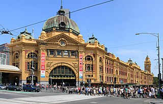
Flagstaff railway station is an underground station on the metro network in Melbourne, Australia. It is one of five stations on the City Loop, which encircles the Melbourne CBD. The station takes its name from the nearby Flagstaff Hill, a significant site in Melbourne's early history, and services Melbourne's legal district. It runs under La Trobe and William Streets, near the north western corner of the CBD.

North Melbourne railway station is the junction station for the Craigieburn, Flemington Racecourse, Sunbury, Upfield, Werribee and Williamstown lines in Victoria, Australia. It serves the north-western Melbourne suburb of West Melbourne, and it opened on 6 October 1859.

South Kensington railway station is located on the Werribee and Williamstown lines in Victoria, Australia. It serves the inner north-western Melbourne suburb of Kensington, and it opened on 11 March 1891.

Footscray railway station is the junction station for the Sunbury, Werribee and Williamstown lines in Victoria, Australia. It serves the western Melbourne suburb of Footscray, and it opened on 17 January 1859.

Newport railway station is the junction station for the Werribee and Williamstown lines in Victoria, Australia. It serves the western Melbourne suburb of Newport, and opened on 1 March 1859 as Geelong Junction. It was renamed Williamstown Junction in January 1869, and renamed Newport on 1 November 1881.

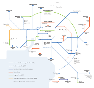
Proposals for expansion of the Melbourne rail network are commonly presented by political parties, government agencies, industry organisations and public transport advocacy groups. The extensions proposed take a variety of forms: electrification of existing routes to incorporate them into the suburban rail system; reconstruction of former passenger rail lines along pre-existing easements; entirely new routes intended to serve new areas with heavy rail or provide alternative routes in congested areas; or track amplification along existing routes to provide segregation of services. Other proposals are for the construction of new or relocated stations on existing lines, to provide improved access to public transport services.
The Sunbury railway line is a suburban electric railway in Melbourne, Australia. It has 15 stations, in Myki ticketing Zones 1 and 2. It is the electrified section of the Bendigo railway within metropolitan Melbourne. Prior to the line extension to Sunbury, the line was known as the Sydenham railway line, and prior to the extension of electrification to Sydenham, the line was known as the St Albans railway line.

Melbourne Central railway station is an underground station on the electrified railway network in Melbourne, Australia. It is one of five stations on the City Loop, which encircles the Melbourne CBD. The station is located under La Trobe Street, between Swanston and Elizabeth Streets, on the northern edge of the central business district (CBD). The station is named after the Melbourne Central Shopping Centre, which it is beneath. It feeds into Melbourne's main metro network station, Flinders Street, and also Southern Cross, Melbourne's main regional terminus. In 2017/2018, it was the third-busiest station on the Melbourne metropolitan rail network, with 15.859 million passenger movements.

The Melbourne rail network is a passenger and freight train system in the city of Melbourne, Victoria, Australia. It is the core of the larger Victorian railway network, with links to both intrastate and interstate systems. A large suburban passenger network centred on the CBD also operates, with a limited degree of segregation from longer-distance passenger and freight trains.

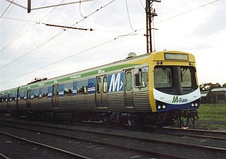
M-Train was a train operator in Melbourne, Australia, and operated some of the city's suburban rail operations. Formed in October 1997 as Bayside Trains, a business unit of the Public Transport Corporation, it was privatised in August 1999 becoming a subsidiary of National Express.

The Doncaster railway line was a long-proposed suburban railway in the eastern suburbs of Melbourne, Victoria, Australia, that was anticipated to be built before December 2027, as a branch, along with the Hurstbridge line, of the planned future Clifton Hill Loop Line, as part of the 2013 PTV Network Development Plan.

The 1969 Melbourne Transportation Plan was a road and rail transport plan for Melbourne, the state capital of Victoria, Australia, instituted by Henry Bolte's state government. Most prominently, the plan recommended the provision of an extensive freeway network, much of which has since been built.

The Metro Tunnel is a metropolitan rail infrastructure project currently under construction in Melbourne, Australia. It includes the construction of twin 9-kilometre rail tunnels between South Kensington and South Yarra with five new underground stations. The southern portal for the tunnel is to be located to the south of South Yarra station. As a result, the tunnel will connect the Pakenham and Cranbourne lines with the Sunbury line, and allow these lines to bypass Flinders Street station and the City Loop while still stopping in the Melbourne central business district.
The Network Development Plan Metropolitan Rail is a long-term development plan for the rail network of Melbourne, Australia. It was carried out by Public Transport Victoria (PTV) and released to the public on 27 March 2013 however, a revised version was leaked in 2019 making a few changes to the plan.
Melbourne Airport Rail is a proposed rail link from the Melbourne CBD to Melbourne Airport at Tullamarine. The planned link is to run through the under-construction Metro Tunnel, running 27 km from the airport to Town Hall station in the city centre with 12 km of new track between the airport and Sunshine station. The link will be a new branch of the Melbourne Metro rail network and run High-Capacity Metro Trains at a 10 minute frequency. The project is being delivered by the Victorian state government agency Rail Projects Victoria.

Rail Projects Victoria (RPV) is an agency of the Government of Victoria, Australia, responsible for the management of certain major infrastructure projects on the Victorian rail network. Originally established as the Melbourne Metro Rail Authority (MMRA), to deliver the Melbourne Metro Rail Project, the office was later expanded in its responsibilities to include the management and planning of a number of major infrastructure programs on V/Line's regional rail services. It was renamed RPV in 2018 to reflect its expanded scope, and later became one of several project teams comprising the Department of Transport's Major Transport Infrastructure Authority.

Melbourne Metro 2 (MM2) is a proposed extension to the Melbourne rail network, consisting of a tunnel from Newport to Clifton Hill via the city centre. Conceived as a follow-up project to the under-construction Metro Tunnel, MM2 would link the Werribee and Mernda suburban rail lines and include stations in the Fishermans Bend development precinct, at Southern Cross and at Parkville, allowing passengers to connect with Metro Tunnel and City Loop lines. Although MM2 has been proposed and refined by a number of government-led and independent reports and proposals, no funding or policy commitment to its planning or construction is in place as of 2019.

The Suburban Rail Loop (SRL) is a proposed fully autonomous orbital line of the rail network of Melbourne, Victoria, Australia. The rapid transit line would traverse suburbs 15–25 kilometres (9.3–15.5 mi) from the Central Business District (CBD) along an approximately 90 km (56 mi) route.


