List of baronies of Northern Ireland

Last updated

This is a list of the historic baronies of Northern Ireland. Baronies were subdivisions of counties, mainly cadastral but with some administrative functions prior to the Local Government (Ireland) Act 1898.

Barony (Ireland) historical subdivision of a county of Ireland

In Ireland, a barony is a historical subdivision of a county, analogous to the hundreds into which the counties of England were divided. Baronies were created during the Tudor reconquest of Ireland, replacing the earlier cantreds formed after the original Norman invasion. Some early baronies were later subdivided into half baronies with the same standing as full baronies.

Northern Ireland Part of the United Kingdom lying in the north-east of the island of Ireland, created 1921

Northern Ireland is a part of the United Kingdom in the north-east of the island of Ireland, variously described as a country, province or region. Northern Ireland shares a border to the south and west with the Republic of Ireland. In 2011, its population was 1,810,863, constituting about 30% of the island's total population and about 3% of the UK's population. Established by the Northern Ireland Act 1998 as part of the Good Friday Agreement, the Northern Ireland Assembly holds responsibility for a range of devolved policy matters, while other areas are reserved for the British government. Northern Ireland co-operates with the Republic of Ireland in some areas, and the Agreement granted the Republic the ability to "put forward views and proposals" with "determined efforts to resolve disagreements between the two governments".

Counties of Ireland Administrative division of Ireland, historically 32 in number

The counties of Ireland are sub-national divisions that have been, and in some cases continue to be, used to geographically demarcate areas of local government. These land divisions were formed following the Norman invasion of Ireland in imitation of the counties then in use as units of local government in the Kingdom of England. The older term "shire" was historically equivalent to "county". The principal function of the county was to impose royal control in the areas of taxation, security and the administration of justice at the local level. Cambro-Norman control was initially limited to the southeastern parts of Ireland; a further four centuries elapsed before the entire island was shired. At the same time, the now obsolete concept of county corporate elevated a small number of towns and cities to a status which was deemed to be no less important than the existing counties in which they lay. This double control mechanism of 32 counties plus 10 counties corporate remained unchanged for a little over two centuries until the early 19th century. Since then, counties have been adapted and in some cases divided by legislation to meet new administrative and political requirements.

Contents

County Antrim

There were 15 baronies in County Antrim: [1] [2]

Antrim Lower Place in Northern Ireland, United Kingdom

Antrim Lower is a barony in County Antrim, Northern Ireland. It is bordered by six other baronies: Antrim Upper to the south; Toome Upper to the south-west; Toome Lower to the west; Kilconway to the north-west; Glenarm Lower to the north-east; and Glenarm Upper to the east. The River Braid flows through this barony.

Antrim Upper Place in Northern Ireland, United Kingdom

Antrim Upper is a barony in County Antrim, Northern Ireland. It is bordered by six other baronies: Antrim Lower to the north; Toome Upper to the west; Massereene Lower to the south-west; Belfast Upper to the south; Belfast Lower to the south-east; and Glenarm Upper to the east.

Belfast Lower Place in Northern Ireland, United Kingdom

Belfast Lower is a barony in County Antrim, Northern Ireland. To its east lies the east-Antrim coast and Belfast Lough, and it is bordered by four other baronies: Belfast Upper to the south, Carrickfergus to the east, Antrim Upper to the west; Glenarm Upper to the north. The Forth and Milewater rivers both flow through Belfast Lower, with Larne harbour also situated in the barony.

County Armagh

There were 8 baronies in County Armagh: [1] [2]

Armagh (barony) Place in Northern Ireland, United Kingdom

Armagh is a barony in County Armagh, Northern Ireland. It lies in the west of the county, bordering County Tyrone with its north-western boundary, and bordering the Republic of Ireland with its southern boundary. It is bordered by five other baronies in Northern Ireland: Tiranny to the west, Dungannon Middle to the north-west, Oneilland West to the north-east, Fews Lower to the east, and Fews Upper to the south-east. It also borders to the south the barony of Cremorne in the Republic of Ireland.

Fews Lower Place in Northern Ireland, United Kingdom

Fews Lower is a barony in County Armagh, Northern Ireland. Its lies in the center of the county, with an enclave lying just to the south-east. The main portion is bordered by four other baronies: Armagh to the west; Oneilland West to the north; Orior Lower to the east; and Fews Upper to the south. Fews Upper and Orior Lower also border the enclave to its north and west, with Orior Upper to its south-west. The Fews Mountains run through both Fews Lower and Upper, the highest peak of which in Fews Lower is, Deadman's Hill, which stands at 1,178 ft. Fews Lower and Upper formed the barony of The Fews until it was sub-divided.

Fews Upper Place in Northern Ireland, United Kingdom

Fews Upper is a barony in County Armagh, Northern Ireland. It lies in the south of the county bordering the Republic of Ireland with its southern and south-western borders. It is bordered by four other baronies in Northern Ireland: Armagh to the west; Fews Lower to the north and west; Orior Lower to the north-west; and Orior Upper to the east. It also borders three baronies in the Republic of Ireland: Cremorne to the west; Dundalk Upper to the south; and Farney to the south-west. Fews Lower and Upper formed the barony of The Fews until it was sub-divided.

County Down

There were 14 baronies in County Down: [1] [2]

Ards Lower Place in Northern Ireland, United Kingdom

Ards Lower, alternatively known as North Ards, is a barony in County Down, Northern Ireland. It lies on the northern half of the Ards Peninsula in the north-east of the county, with the Irish Sea to its east and Strangford Lough to its south-west. It is bordered by two other baronies: Ards Upper to the south; and Castlereagh Lower to the west.

Ards Upper Place in Northern Ireland, United Kingdom

Ards Upper is a barony in County Down, Northern Ireland. It lies on the southern half of the Ards Peninsula in the east of the county, with the Irish Sea to its east and Strangford Lough to its west. It is bordered by two other baronies: Ards Lower to the north; and Lecale Lower just across the mouth of Strangford Lough to the south.

Castlereagh Lower Place in Northern Ireland, United Kingdom

Castlereagh Lower is a historic barony in County Down, Northern Ireland. It was created by 1841 with the division of Castlereagh into two. It is bordered by three other baronies: Ards Lower to the east; Dufferin to the south; and Castlereagh Upper to the west and south-west. Castlereagh Lower is also bounded by Belfast Lough to the north and Strangford Lough to the south-east.

County Fermanagh

There were 8 baronies in County Fermanagh: [1] [2]

Clanawley Place in Northern Ireland, United Kingdom

Clanawley is a barony in County Fermanagh, Northern Ireland. To its east lies Upper Lough Erne, and it is bordered by three other baronies: Magheraboy to the north; Tirkennedy and Knockninny to the east. It also borders three baronies in the Republic of Ireland: Tullyhaw to the south; and Drumahaire and Rosclogher to the west.

Clankelly Place in Northern Ireland, United Kingdom

Clankelly is a barony in County Fermanagh, Northern Ireland. It is the only barony in County Fermanagh not connected to Lough Erne. It is bordered by two other baronies in Northern Ireland: Coole to the south-west; and Magherastephana to the north-west. It also borders two baronies in the Republic of Ireland: Monaghan to the north-east; and Dartree to the south-east.

Coole (barony) Place in Northern Ireland, United Kingdom

Coole is a barony in County Fermanagh, Northern Ireland. To its west lies Upper Lough Erne, and it is bordered by three other baronies in Northern Ireland: Knockninny to the west; Magherastephana to the north; and Clankelly. It also borders three baronies in the Republic of Ireland: Dartree to the east; Tullygarvey and Loughtee Lower to the south.

County Londonderry

There were 6 baronies in County Londonderry: [1] [2]

County Tyrone

There were 8 baronies in County Tyrone: [1] [2]

See also

Related Research Articles

County Antrim Place in Antrim, Northern Ireland

County Antrim is one of six counties that form Northern Ireland. Adjoined to the north-east shore of Lough Neagh, the county covers an area of 3,046 square kilometres (1,176 sq mi) and has a population of about 618,000. County Antrim has a population density of 203 people per square kilometre or 526 people per square mile. It is also one of the thirty-two traditional counties of Ireland, as well as part of the historic province of Ulster.

County Down Place in Northern Ireland, United Kingdom

County Down is one of six counties that form Northern Ireland, in the northeast of the island of Ireland. It covers an area of 2,448 km2 and has a population of 531,665. It is also one of the thirty-two traditional counties of Ireland and is within the province of Ulster. It borders County Antrim to the north, the Irish Sea to the east, County Armagh to the west, and County Louth across Carlingford Lough to the southwest.

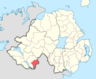
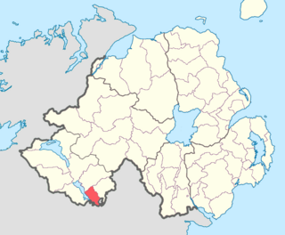
The Route, also historically known as Reuta, Rowte, or in Irish: an Rúta, was a medieval territory in County Antrim, Northern Ireland, consisting of the baronies of Dunluce Upper, Dunluce Lower, Toome Lower, and the North East Liberties of Coleraine. It also formed part of the more ancient kingdoms of Dál Riata and Dál nAraidi, as well as part of the Earldom of Ulster. It was once ruled by the MacQuillans and later the MacDonnells.

Loughinsholin Place in Northern Ireland, United Kingdom

Loughinsholin is a barony in County Londonderry, Northern Ireland. Its southeast borders the northwest shore of Lough Neagh, and itself is bordered by seven other baronies: Dungannon Upper to the south; Strabane Upper to the west; Keenaght and Coleraine to the north; Kilconway, Toome Upper, and Toome Lower to the east. It was formed largely on the extent of the medieval Irish túath of Uí Tuirtri.

North East Liberties of Coleraine in Northern Ireland, United Kingdom

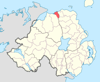
The North East Liberties of Coleraine is a barony in County Londonderry, Northern Ireland. It borders the north-Londonderry coastline, and is bordered by three other baronies: Coleraine to the west; Dunluce Lower to the north-east; Dunluce Upper to the south-east. The North East Liberties of Coleraine formed the north-western part of the medieval territory known as the Route.

Dunluce Upper Place in Northern Ireland, United Kingdom

Dunluce Upper is a barony in County Antrim, Northern Ireland. It is bordered by six other baronies: Dunluce Lower to the north; Cary to the north-east; North East Liberties of Coleraine to the north-west; Coleraine to the west; Kilconway to the south; and Glenarm Lower to the east. Dunluce Upper also formed part of the medieval territory known as the Route.

Kilconway Place in Northern Ireland, United Kingdom

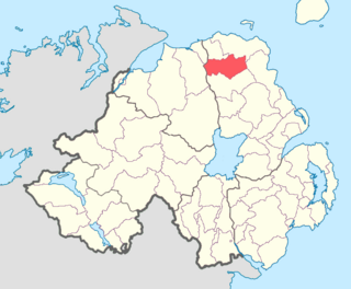
Kilconway is a barony in County Antrim, Northern Ireland. It is bordered by six other baronies: Dunluce Upper to the north; Glenarm Lower to the east; Antrim Lower to the south-east; Toome Lower to the south; Loughinsholin to the south-west; and Coleraine to the north-east. Kilconway also formed part of the medieval territory known as the Route. Springmount Bog is located within the barony.

Massereene Upper Place in Northern Ireland, United Kingdom

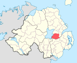
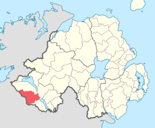
Massereene Upper is a barony in County Antrim, Northern Ireland. To its east lies Belfast Lough, and it is bordered by four other baronies: Massereene Lower to the north; Belfast Upper to the east; Castlereagh Upper to the south-east; and Iveagh Lower, Lower Half to the south-west.

Dungannon Middle in Northern Ireland, United Kingdom

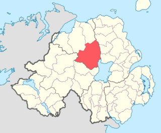
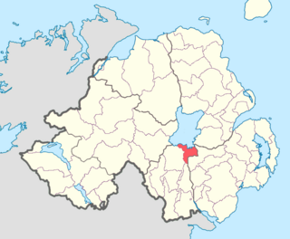
Dungannon Middle is a barony in County Tyrone, Northern Ireland. It was created in 1851 with the splitting of the barony of Dungannon. It is bordered by Lough Neagh to the east and six other baronies: Dungannon Upper to the north; Oneilland West to the south-east; Armagh and Tiranny to the south; Dungannon Lower to the south-west; and Omagh East to the west.

Oneilland West Place in Northern Ireland, United Kingdom

Oneilland West is a barony in County Armagh, Northern Ireland. It is also called Clancann, after the McCann clan. It lies in the north of the county on the south-western shore of Lough Neagh and the border of County Tyrone. Oneilland West is bordered by five other baronies: Armagh to the west; Dungannon Middle to the north-west; Oneilland East to the north-east; Orior Lower to the south-east; and Kinelarty to the south.

Oneilland East Place in Northern Ireland, United Kingdom

Oneilland East is a barony in the north-east of County Armagh, Northern Ireland. It is also called Clanbrasil. It lies in the north-east corner of the county, on the south-eastern shore of Lough Neagh and the boundary with County Down. Oneilland East is bordered by three other baronies: Oneilland West to the west; Iveagh Lower to the east; and Orior Lower to the south.

Orior Lower Place in Northern Ireland, United Kingdom

Orior Lower is a barony in County Armagh, Northern Ireland. It lies in the east of the county and borders County Down with its eastern boundary. It is bordered by seven other baronies: Fews Upper to the south-west; Fews Lower to the west; Oneilland West to the north-west; Oneilland East to the north; Iveagh Lower, Lower Half to the north-east; Iveagh Upper, Upper Half to the east; and Orior Upper to the south. A small enclave of Orior Lower resides in the east of Orior Upper.

Orior Upper Place in Northern Ireland, United Kingdom

Orior Upper is a barony in County Armagh, Northern Ireland. It lies in the south-east of the county and borders the Republic of Ireland with its southern boundary. It is bordered by five other baronies in Northern Ireland: Fews Upper and an enclave of Fews Lower to the west; Orior Lower to the north; Iveagh Upper, Upper Half to its west, which is divided in two by the Lordship of Newry. It also borders two baronies in the Republic of Ireland: Dundalk Lower and Dundalk Upper to the south.

Iveagh Upper, Lower Half Place in Northern Ireland, United Kingdom

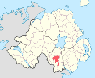
Iveagh Upper, Lower Half is the name of a barony in County Down, Northern Ireland. It was created by 1851 with the division of the barony of Iveagh Upper into two. It lies in the centre of the county, and is bordered by six other baronies: Iveagh Upper, Upper Half and Lordship of Newry to the west; Mourne to the south; Kinelarty and Lecale Upper to the east; and Iveagh Lower, Upper Half to the north.

Iveagh Lower, Upper Half Place in Northern Ireland, United Kingdom

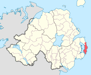
Iveagh Lower, Upper Half is the name of a barony in County Down, Northern Ireland. It was created by 1851 with the division of the barony of Iveagh Lower into two. It is bordered by five other baronies: Iveagh Upper, Lower Half to the south; Iveagh Upper, Upper Half to the south-west; Iveagh Lower, Lower Half to the west and north; Castlereagh Upper to the north-east; and Kinelarty to the west.

Iveagh Lower, Lower Half Place in Northern Ireland, United Kingdom

Iveagh Lower, Lower Half is the name of a barony in County Down, Northern Ireland. It was created by 1851 with the division of the barony of Iveagh Lower into two. It is bordered by six other baronies: Massereene Upper to the north; Castlereagh Upper to the east; Iveagh Lower, Upper Half and Iveagh Upper, Upper Half to the south; Oneilland East and Orior Lower to the west.

Castlereagh Upper Place in Northern Ireland, United Kingdom

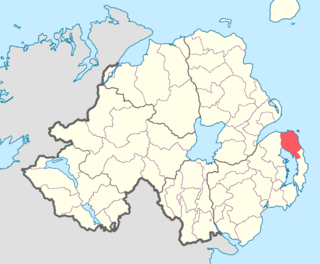
Castlereagh Upper is a historic barony in County Down, Northern Ireland. It was created by 1841 with the division of Castlereagh into two. It is bordered by eight other baronies: Castlereagh Lower and Dufferin to the east; Lecale Lower and Kinelarty to the south; Iveagh Lower, Lower Half, Iveagh Lower, Upper Half, and Massereene Upper to the west; and Belfast Upper to the north.

References

  1. 1 2 3 4 5 6 "Baronies of Northern Ireland". Placenames Database of Ireland. Retrieved 11 April 2015.
  2. 1 2 3 4 5 6 "Baronies of Northern Ireland". IreAtlas Townland Database. Retrieved 11 April 2015.