List of cities and towns in Namibia

Last updated

Map of Namibia Namibia map.png
Map of Namibia
Windhoek, Capital of Namibia Windhoek aerial.jpg
Windhoek, Capital of Namibia
Walvis Bay Walvis Bay aerial.jpg
Walvis Bay
Swakopmund Mole, Jetty and Lighthouse Swakopmund, Namibia.jpg
Swakopmund

Cities and towns in Namibia are distinguished by the status the Government of Namibia has vested in them: Places in Namibia that are governed by a municipality are cities, places with a town council are towns. [1]
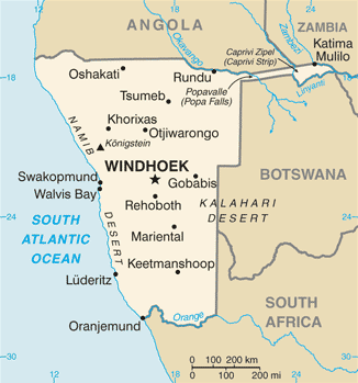
Contents

Cities

As of 2015 Namibia has thirteen cities, each of them governed by a municipality council that has between 7 and 15 seats. Compared to towns, cities have the authority to set up facilities like public transport, housing schemes, museums, and libraries without the approval of the Minister of Urban and Rural Development. They may also decide to privatise certain services and to enter into joint ventures with the private sector without asking for explicit approval. The thirteen cities are: [2]

Cities in Namibia
CityRegionCensus 1991Census 2001 [3] Census 2011 [3] Census 2023 [4]
Windhoek Khomas 147,056233,529325,858486,169
Walvis Bay Erongo 22,99943,61162,096118,625
Swakopmund Erongo 17,68123,80844,72575,921
Henties Bay Erongo 3,2854,7207,569
Omaruru Erongo 4,7616,30010,670
Otjiwarongo Otjozondjupa 15,92119,61428,24949,022
Okahandja Otjozondjupa 11,04014,03922,63945,159
Grootfontein Otjozondjupa 14,24916,63226,839
Mariental Hardap 9,83612,47815,475
Outjo Kunene 6,0138,44515,063
Gobabis Omaheke 13,85619,10133,404
Tsumeb Oshikoto 14,92919,27534,960
Keetmanshoop ǁKaras 15,03215,77820,97727,862

Towns

As of 2015 Namibia has 26 towns, each of them governed by a town council that has between 7 and 12 seats. Compared to villages, towns have the authority to set up facilities like ambulance and fire fighting services and electricity supply without the approval of the Minister of Urban and Rural Development. They are also responsible for erecting and maintaining community buildings, and they may buy and sell movable property without asking for explicit approval. The 26 towns are: [2]

Towns in Namibia
TownRegionCensus 1991Census 2001 [3] Census 2011 [3] 2023 Census [4]
Karasburg ǁKaras 4,0754,4016,621
Lüderitz ǁKaras 13,29512,53716,125
Oranjemund ǁKaras 4,4513,9087,441
Arandis Erongo 3,9745,2145,726
Karibib Erongo 3,7265,1326,938
Usakos Erongo 2,9263,5835,094
Aranos Hardap 3,6835,493
Rehoboth Hardap 21,43921,30828,84340,788
Rundu Kavango East 19,36636,96463,431118,625
Nkurenkuru Kavango West 61810,261
Khorixas Kunene 5,8906,7969,371
Opuwo Kunene 5,1017,65712,335
Eenhana Ohangwena 2,8145,52816,588
Helao Nafidi Ohangwena ------ (established 2004)19,37528,508
Okahao Omusati 1,6654,519
Oshikuku Omusati 2,7615,499
Outapi Omusati 2,6406,43713,671
Ruacana Omusati 2,9855,939
Oshakati Oshana 21,60328,25536,54158,696
Ondangwa Oshana 7,92610,90022,82230,679
Ongwediva Oshana 6,19710,74220,26027,784
Omuthiya Oshikoto 3,7947,560
Oniipa Oshikoto ---4,740
Okakarara Otjozondjupa 3,2964,7097,123
Otavi Otjozondjupa 3,8135,24210,756
Katima Mulilo Zambezi 13,37722,13428,36246,401

See also

Related Research Articles

<span class="mw-page-title-main">Windhoek</span> Capital and largest city of Namibia

Windhoek is the capital and largest city of Namibia. It is located in central Namibia in the Khomas Highland plateau area, at around 1,700 m (5,600 ft) above sea level, almost exactly at the country's geographical centre. The population of Windhoek, which was 486,169 in 2023, is constantly growing due to a continued migration from other regions in Namibia.

<span class="mw-page-title-main">Oranjemund</span> Town in ǁKaras Region, Namibia

Oranjemund is a diamond mining town of 4,000 inhabitants situated in the ǁKaras Region of the extreme southwest of Namibia, on the northern bank of the Orange River mouth at the border to South Africa.

<span class="mw-page-title-main">Gobabis</span> City in Omaheke Region, Namibia

Gobabis is a town in eastern Namibia. It is the regional capital of the Omaheke Region, and the district capital of the Gobabis electoral constituency. Gobabis is situated 200 km (120 mi) down the B6 motorway from Windhoek to Botswana. The town is 113 km (70 mi) from the Buitepos border post with Botswana, and serves as an important link to South Africa on the tarred Trans-Kalahari Highway. Gobabis is in the heart of the cattle farming area. In fact Gobabis is so proud of its cattle farming that a statue of a large Brahman bull with the inscription "Cattle Country" greets visitors to the town. Gobabis also has its own local airport.

<span class="mw-page-title-main">Grootfontein</span> City in the Otjozondjupa Region of central Namibia

Grootfontein is a town with 26,839 inhabitants in the Otjozondjupa Region of central Namibia. It is one of the three towns in the Otavi Triangle, situated on the B8 national road that leads from Otavi to the Caprivi Strip.

<span class="mw-page-title-main">Keetmanshoop</span> City in ǁKaras Region, Namibia

Keetmanshoop is a town in the ǁKaras Region of southern Namibia, lying on the Trans-Namib Railway from Windhoek to Upington in South Africa. It is named after Johann Keetman, a German industrialist and benefactor of the city.

<span class="mw-page-title-main">Karibib</span> Town in Erongo Region, Namibia

Karibib is a town in the Erongo Region of western Namibia. It has 3,800 inhabitants and owns 97 square kilometres (37 sq mi) of town land. Karibib is the district capital of the Karibib electoral constituency. It is situated on the Khan River, halfway between Windhoek and Swakopmund on the B2, the main road between Walvis Bay and Johannesburg. The town is known for its aragonite marble quarries and the Navachab Gold Mine.

<span class="mw-page-title-main">Katima Mulilo</span> Town in Zambezi Region, Namibia

Katima Mulilo or simply Katima is the capital of the Zambezi Region in Namibia. It had 46,401 inhabitants in 2023, and comprises two electoral constituencies, Katima Mulilo Rural and Katima Mulilo Urban. It is located on the B8 national road on the banks of the Zambezi River in the Caprivi Strip in lush riverine vegetation with tropical birds and monkeys. The town receives annual average rainfall of 654 millimetres (25.7 in).

Okahandja is a city of 45,159 inhabitants in Otjozondjupa Region, central Namibia, and the district capital of the Okahandja electoral constituency. It is known as the Garden Town of Namibia. It is located 70 km north of Windhoek on the B1 road. It was founded around 1800, by two local groups, the Herero and the Nama.

<span class="mw-page-title-main">Mariental, Namibia</span> City in Hardap Region, Namibia

Mariental is a town of 10,000 inhabitants in south-central Namibia, lying on the B1 national road 232 kilometres (144 mi) north of Keetmanshoop and 274 kilometres (170 mi) southeast of Windhoek. It lies at an elevation of 1,090 metres (3,580 ft). Mariental is connected to the TransNamib railway line from Windhoek to Keetmanshoop. The town and the surrounding area are situated in a hot, arid region.

<span class="mw-page-title-main">Rundu</span> Town in Kavango-East Region, Namibia

Rundu is the capital and largest city of the Kavango-East Region in northern Namibia. It lies on the border with Angola on the banks of the Kavango River about 1,000 metres above sea level. Rundu's population is growing rapidly. The 2001 census counted 36,964 inhabitants; and for the 2011 census it has climbed to 63,430.

<span class="mw-page-title-main">Oshakati</span> Town in Oshana Region, Namibia

Oshakati is a town in northern Namibia. It is the regional capital of the Oshana Region and one of Namibia's largest cities both by population and as an economic center.

<span class="mw-page-title-main">Karasburg</span> Town in ǁKaras Region, Namibia

Karasburg is a town with 4,000 inhabitants in the ǁKaras Region of southern Namibia and the district capital of the Karasburg electoral constituency. It lies at the heart of the southern Namibian sheep farming industry.

<span class="mw-page-title-main">Outjo</span> City in Kunene Region, Namibia

Outjo is a town of 15,000 inhabitants in the Kunene Region of Namibia. It is the district capital of Outjo Constituency. It is best known as the main gateway to Etosha National Park.

<span class="mw-page-title-main">Opuwo</span> Town in Kunene Region, Namibia

Opuwo is the capital of the Kunene Region in north-western Namibia. The town is situated about 720 km north-northwest of the capital Windhoek, and has a population of around 12,300 (2023). It is the commercial hub of the Kunene Region.

<span class="mw-page-title-main">Outapi</span> Town in northern Namibia

Outapi wa Nakafingo na Temba, also Outapi or Uutapi and Ombalantu, is a town in northern Namibia near the border with Angola, situated 90 km (56 mi) northwest of Oshakati. It is the capital of the Omusati region and the district capital of the Outapi electoral constituency. The language spoken there is Oshiwambo.

<span class="mw-page-title-main">Otavi</span> Town in Otjozondjupa Region, Namibia

Otavi is a town with 10,000 inhabitants in the Otjozondjupa Region of Namibia. Situated 360 km north of Windhoek, it is the district capital of the Otavi electoral constituency.

<span class="mw-page-title-main">Arandis, Namibia</span> Town in the Erongo Region of Namibia

Arandis is a mining town in the Erongo Region of western central Namibia. Originally a camp for workers of the nearby Rössing uranium mine, Arandis was declared a town in 1994.

<span class="mw-page-title-main">Ongwediva</span> Town in Oshana Region, Namibia

Ongwediva is a town in the Oshana Region in the north of Namibia. It is the district capital of the Ongwediva electoral constituency. As of 2023 it had 28,000 inhabitants and covered 4,102 hectares of land. Ongwediva has seven churches, two private schools and 13 government-run schools. Most of the inhabitants speak Oshiwambo.

Okakarara is a town in Otjozondjupa Region, Namibia, located 50 kilometres (31 mi) southeast of Waterberg National Park. It has an estimated population of 7,000 and is currently growing by 1,500 inhabitants annually.

References

Literature

  1. Hartman, Adam (27 Aug 2010). "Town regrading a 'sad move'". The Namibian . p. 1. Archived from the original on 2012-03-17.
  2. 1 2 "Know Your Local Authority". Election Watch. No. 3. Institute for Public Policy Research. 2015. p. 4.
  3. 1 2 3 4 "Table 4.2.2 Urban population by Census years (2001 and 2011)" (PDF). Namibia 2011 - Population and Housing Census Main Report. Namibia Statistics Agency. p. 40. Retrieved 19 May 2017.
  4. 1 2 "2023 Population & Housing Census Preliminary Report" (PDF). Statistics Namibia.

Further reading