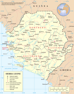
Sierra Leone, officially the Republic of Sierra Leone, is a country on the southwest coast of West Africa. It shares its southeastern border with Liberia, and the northern half is surrounded by Guinea. Covering a total area of 71,740 km2 (27,699 sq mi), it has a tropical climate, with environments ranging from savanna to rainforests. It has a population of 7,092,113 as of the 2015 census. Freetown is the capital and largest city. The country is divided into five administrative regions, which are subdivided into 16 districts.
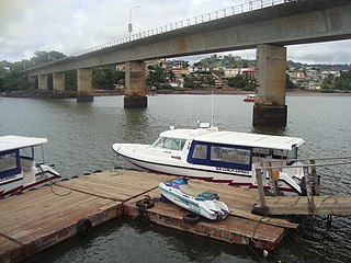
Freetown is the capital and largest city of Sierra Leone. It is a major port city on the Atlantic Ocean and is located in the Western Area of the country. Freetown is Sierra Leone's major urban, economic, financial, cultural, educational and political centre, as it is the seat of the Government of Sierra Leone. The population of Freetown was 1,055,964 at the 2015 census.

The provinces of Sierra Leone are divided into 16 districts, as of July 2017. Previously, the country was divided into 14 districts. The Western Area is divided into two districts. Sierra Leone's capital Freetown is located in the Western Area of the country and its makes up the Western Area Urban District.

Bo, also commonly referred to as Bo Town, is the second largest city in Sierra Leone by landscape/geographical location and the largest city in the Southern Province. Bo is the capital and administrative centre of Bo District. The city of Bo had a population of 149,957 in the 2004 census and had a population of about 233,684 based on 2017 estimate. Bo is an urban centre, and lies approximately 160 miles (250 km) east-southeast of Freetown, and about 40 miles (71 km) to Kenema. Bo is the leading financial, educational and economic centre of southern Sierra Leone.

Kabala is the capital and largest town of Koinadugu District in the Northern Province of Sierra Leone. Kabala is one of the main towns in Northern Sierra Leone and is set in a rural landscape, surrounded by mountains.

Kenema is the third largest city in Sierra Leone, and the largest city in the country's Eastern Province. It is the capital of Kenema District and a major economic center of the Eastern Province. At the 2015 national census, Kenema had a population of 200,354. Kenema is located approximately 200 miles from Freetown, and 60 kilometres (40 mi) south of Bo.

Bo District is a district in the Southern Province of Sierra Leone. It is one of the sixteen Districts of Sierra Leone. Bo District is the second most populous District in Sierra Leone. Its capital and largest city is the city of Bo, which is also the second most populous city in Sierra Leone. other major towns in the district include Baoma, Bumpeh, Serabu, Sumbuya, Baiima and Yele.

The Western Area or Freetown Peninsula is one of five principal divisions of Sierra Leone. It comprises the oldest city and national capital Freetown and its surrounding towns and countryside. It covers an area of 557 km2 and has a population of 1,447,271. The Western Area is located mostly around the peninsula and is divided into two districts: the Western Area Rural and the Western Area Urban.
Port Loko is the capital of Port Loko District and since 2017 the North West Province of Sierra Leone. The city had a population of 21,961 in the 2004 census and current estimate of 44,900. Port Loko lies approximately 36 miles north-east of Freetown. The area in and around Port Loko is a major bauxite mining and trade centre. The town lies on the main highway linking Freetown to Guinea's capital Conakry. It also lies on the over-land highway between Freetown and its major airport, Lungi International Airport, although most travellers complete this journey via the much shorter ferry or helicopter transit.

Bonthe District is a district that comprises several islands and mainland of the Atlantic Ocean in the Southern Province of Sierra Leone. Bonthe is one of the sixteen districts of Sierra Leone. Its capital is the town of Bonthe Island and its largest city is Bonthe, on Sherbro Island. As of the 2015 census, the district had a population of 200,730. Bonthe District is one of the sixteen districts of Sierra Leone. Bonthe District is subdivided into eleven chiefdoms.
Bonthe is a coastal town located on Sherbro Island in Bonthe District in the southern Province of Sierra Leone. The town lies on the eastern shore of Sherbro Island, on the Sherbro River estuary. Bonthe is about 60 miles south-west of Bo and 187 miles south-east of Freetown.
Magburaka is the capital and largest city of Tonkolili District in the Northern Province of Sierra Leone. Its population was 16,313 in the 2004 census. and a current estimate of 40,313. It is located at around 8°43′1″N11°56′36″W, along the Rokel River. Magburaka lies just about 26 miles (42 km) drive south-west of Makeni, the economic center of Northern Sierra Leone and about 80 miles (135 km) drive east of the country's capital Freetown. Magburaka is a trade center and is one of the main cities in Northern Sierra Leone. As with most parts of Sierra Leone, the Krio language of the Sierra Leone Creole people is the most widely spoken language in Magburaka.
Kono District is a district in the Eastern Province of Sierra Leone. Its capital and largest city is Koidu Town. Motema is the second most populous city in the district. The other major towns in the district include Yengema, Tombodu, Jaiama Nimikor and Sewafe. The district is the largest diamond producer in Sierra Leone. The population of Kono District is 505,767. Kono District borders Kenema District to the southwest, The Republic of Guinea to the east, Koinadugu District to the northeast and Kailahun District to the southeast. Kono District is divided into fourteen chiefdoms.

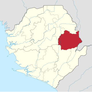
Kenema District is a district in the Eastern Province of Sierra Leone. Its capital and largest city is Kenema, which is the third most populous city in Sierra Leone, after Freetown and Bo. Tongo is the second most populous city in the district. Other major towns in Kenema District include Blama and Yomboma. The district is the most populous district in the Eastern province with a population 609,873. Kenema District has an area of 6,053 km2 (2,337 sq mi) and comprises sixteen chiefdoms.

The Western Area Rural District is one of the sixteen districts of Sierra Leone. It is located mostly around the peninsula in the Western Area of Sierra Leone. The Western Area Rural District has a 2015 census population of 442,951. The district capital and largest city is Waterloo. Other major towns in the district include Newton, Benguema, Leicester, Tombo and Regent. Most of the towns and villages in the Western area rural District are close to the capital Freetown; and are part of the Freetown Metropolitan Area.
Petifu is a rural town in Port Loko District in the Northern Province of Sierra Leone. Petifu lies about 20 miles to Lungi. The town population is predominantly from the Susu, Temne and Fula ethnic group. The town is predominantly muslim.

Sierra Leone is officially a secular state, although Islam and Christianity are the two main and dominant religions in the country. The constitution of Sierra Leone provides for freedom of religion and the Sierra Leone Government generally protects it. The Sierra Leone Government is constitutionally forbidden from establishing a state religion, though Muslim and Christian prayers are usually held in the country at the beginning of major political occasions, including presidential inauguration.
Bumpe is a small town in Bo District in the Southern Province of Sierra Leone. As of 2013 it had an estimated population of 16,123. The town is located south-west of Bo.
The following is a timeline of the history of the city of Freetown, Sierra Leone.