
Astley and Tyldesley are situated on the Manchester Coalfield, historically in Lancashire, now in Greater Manchester, England.
Astley and Tyldesley are situated on the Manchester Coalfield, historically in Lancashire, now in Greater Manchester, England.
The underlying geology of Astley and Tyldesley comprises the sandstones, shales and coal seams of the Middle Coal Measures laid down during the Carboniferous period more than 300 million years ago and which outcrop from Shakerley to New Manchester where coal was mined from seams between the Worsley Four Foot and Arley mines. [lower-alpha 1] The seams generally dip towards the south and west and are affected by small faults. The Upper Coal Measures are not worked in this part of the coalfield. To the south of Astley the Coal Measures dip beneath the Permo-Triassic New Red Sandstone.
Coal was got in Tyldesley in 1429 when a dispute over "seacole" was recorded. It was used in the smithies of the Shakerley nailers. Some of the earliest small coal pits belonged to Francis Egerton, 3rd Duke of Bridgewater, and his successors the Bridgewater Trustees, and were situated at the east of the township near Chaddock Lane, and north at New Manchester where the coal seams outcropped. Other colliery companies operating in the area included Tyldesley Coal Company whose pits were north of Manchester Road as were those of the Shakerley Collieries. Astley and Tyldesley Collieries had coal mines at Gin Pit to the south of the railway. The last pit to open was Astley Green Colliery by the Bridgewater Canal in Astley Green.
Some of these companies joined with others to form Manchester Collieries in 1929 as a response to the decline in coal mining and better survive the difficult economic conditions of the time. Several collieries survived until after nationalisation in 1947. [1] The last colliery to close was Astley Green in 1970.
| Colliery | Locality | Owner | Notes | Refs |
|---|---|---|---|---|
| Astley Green Colliery 53°29′42″N2°26′49″W / 53.495°N 2.447°W | Astley Green | Clifton and Kersley Coal Company | Astley Green Colliery was sunk by a subsidiary of the Clifton and Kersley Coal Company immediately to the north of the Bridgewater Canal to exploit the deep coal seams under Chat Moss where the exposed coalfield dips under the Permian strata. Shaft sinking started in 1908 and the pit opened in 1912. The colliery was absorbed into Manchester Collieries in 1929 and nationalised in 1947. The pit closed in 1970 and is now the site of Astley Green Colliery Museum. | |
| Chaddock Pit 53°30′07″N2°25′41″W / 53.502°N 2.428°W | Tyldesley, south of Chaddock Lane | Bridgewater Trustees | Chaddock Pit had two shafts, an engine pit for pumping and a winding shaft. It was sunk around 1820 and was operating in 1837 when it was the biggest coal mine in the Tyldesley township. [2] It was connected to the Bridgewater Canal at Boothstown basin by an underground level. [3] [4] In 1840 the Chaddock Pits employed 54 colliers, 55 boys, 35 girls and 19 boatmen. [5] The mines worked from the Chaddock Level were closed by 1842. [6] The extent of the navigable level in the Chaddock Pit was 814 yards to the west and 1,178 yards to the east in the four Foot mine. | [7] |
| Cleworth Hall Colliery 53°31′01″N2°27′12″W / 53.5169°N 2.4532°W | Tyldesley, north of Manchester Road | Tyldesley Coal Company | The two original shafts at Cleworth Hall were sunk in 1874. The Crombouke mine was reached at 71 yards, the Rams mine at 115 yards and the Black and White at 220 yards. As reserves from these seams were worked out, a third shaft was sunk to the Trencherbone mine accessing several other seams. At the bottom of No.2 shaft was a furnace, this was the upcast ventilation shaft for the pit. The colliery was owned by the Tyldesley Coal Company until it was nationalised in 1947. | [8] [9] [10] [11] |
| Combermere Colliery 53°31′26″N2°27′11″W / 53.524°N 2.453°W | Tyldesley, Combermere Lane | Tyldesley Coal Company | Combermere Colliery had two shafts to the Rams and Black and White mines. Coal production ceased in 1893 but the pit continued to produce fireclay to supply brickworks that were built on the site. | [8] [9] [12] |
| Cross Hillock Pit 53°29′56″N2°27′36″W / 53.499°N 2.460°W | Astley | Astley and Tyldesley Collieries | Cross Hillock Pit was sunk by Astley and Tyldesley Collieries south-east of the junction of Manchester Road and Higher Green Lane. It was liable to flooding and closed by 1887. | |
| Ellenbrook | New Manchester | Bridgewater Trustees | The Ellenbrook Pit had two shafts for winding coal from the Worsley Four Foot mine and was operational by 1870. | [8] [5] |
| Gatley | New Manchester | Thomas Fletcher. | Gatley Pit's two shafts were sunk to the Worsley Four Foot mine between 1840 and 1850. | [8] [5] |
| Gin Pit Colliery 53°30′12″N2°28′10″W / 53.5034°N 2.4695°W | Tyldesley, Gin Pit | Astley and Tyldesley Salt Company | The modern colliery was sunk in 1866 in an area where coal had previously been mined. Gin Pit worked the Crombouke and Six Foot mines. When they were worked out the Brassey mine was developed. [13] The colliery closed in 1958. | [9] [14] [15] |
| Great Boys Colliery | Tyldesley, north of Sale Lane | William Atkin 1854, Thomas Fletcher and Sons | Great Boys colliery was situated on the north side of Sale Lane in Tyldesley west of the Colliers Arms public house. It was begun by William Atkin and sold in 1855 to John Fletcher and Samuel Scowcroft. The company had become John Fletcher and Sons in 1877. Shafts were sunk on Pear Tree Farm, near Mort Lane and these became part of Great Boys Colliery which closed before 1885. The colliery accessed the Brassey mine at about 170 yards and the Six Feet mine at 182 yards. | [8] [16] |
| Henfold Pit, west of Chaddock Lane | Tyldesley | Bridgewater Trustees | The Henfold Pit under the Chaddock Hall estate was sunk to the Worsley Four Foot mine around 1820 and was connected by an underground level to the Chaddock Pit and the Worsley Navigable Levels at Ingles Pit in Worsley. [3] A tunnel eastwards connected it to the Queen Anne Pit near Chaddock Lane. The mines worked from the Chaddock Level were closed by 1842. The extent the branch of the navigable level at the pit was 1,914 yards. | [6] [7] |
| Mosley Common Colliery 53°30′29″N2°25′01″W / 53.508°N 2.417°W | Mosley Common | Bridgewater Trustees | In 1862 work began at Mosley Common to access the deeper seams earlier mining had not reached. Five shafts were sunk. In 1923 the Mosley Common, Nos 1, 2 and 5 pits employed 1,338 underground and 198 surface workers while Nos 3 and 4 pits employed 951 underground and 143 above ground. Mosley Common was one of the country's largest and most modern pits after refurbishment and development work in the 1960s when it employed 3000 workers. The colliery closed in 1968 though its coal reserves had not been exhausted. The site was cleared by 1974. | |
| Nelson Pit originally Shakerley Colliery (Ramsdens) 53°31′19″N2°27′54″W / 53.522°N 2.465°W | Shakerley, east of Lancaster Avenue | Shakerley Collieries | Shakerley Colliery was sunk in the late 1830s north of Shakerley Hall on land owned by Ellis Fletcher. It was renamed Nelson Pit in the early 1880s. The colliery was sold to Manchester Collieries in 1935 and closed in 1938. | [9] [17] |
| New Lester Colliery 53°31′08″N2°26′10″W / 53.519°N 2.436°W | Tyldesley, Mort Lane | James Roscoe | New Lester Colliery was owned by James Roscoe and two shafts were sunk in about 1865 on the east side of Mort Lane. James Roscoe and Sons was formed in 1892 and operated until 1938 when Peel Collieries took ove. New Lester shafts accessed the Arley mine (seam), the Yard mine, the Four foot, Cannel, Plodder and Three Quarters mines. In 1939 the colliery employed 499 men underground and 169 surface workers. The colliery was closed by 1947. | [8] [9] |
| Nook Colliery 53°30′26″N2°28′10″W / 53.5073°N 2.4694°W | Tyldesley, Gin Pit | Astley and Tyldesley Coal and Salt Company | Nook's first shaft was sunk to the Rams mine in 1866 by the Astley and Tyldesley Coal and Salt Company. The colliery expanded and eventually had five shafts and became one of the largest pits on the coalfield. No.2 upcast shaft was sunk in 1873 and deepened to the Arley mine. No.3 shaft was sunk the Trencherbone mine through water bearing rock in 1899. No.4 shaft, sunk in 1913, intersected every workable coal seam. The colliery became part of Manchester Collieries in 1929 and the National Coal Board in 1947. | [8] [9] [14] |
| Pear Tree | Tyldesley | Tyldesley Coal Company | Shafts were sunk on Pear Tree Farm, near Mort Lane and these became part of Great Boys Colliery which closed before 1885. | |
| Peel | Tyldesley, accessed from Little Hulton | Thomas Grundy | Thomas Grundy sank Peel Colliery in the north of the township near the border with Little Hulton. | [16] |
| Peelwood Colliery 53°31′38″N2°27′53″W / 53.5272°N 2.4646°W | Tyldesley, off Engine Lane, Shakerley | Tyldesley Coal Company | Peelwood began producing coal in 1883. The colliery had two shafts accessing the Trencherbone and Seven Feet mines. | [9] [12] |
| Queen Anne Pit | Tyldesley Chaddock Lane | Bridgewater Trustees | The Queen Anne Pit was sunk by 1820 to the Worsley Four Foot mine. It was connected by underground levels to Chaddock Pit and Ingles Pit. A tunnel linked the pit with Henfold Pit to the west. The mines worked from the Chaddock Level were closed by 1842. The extent of the navigable levels was 902 yards to the west and 506 yards to the east. | [3] [6] [7] |
| Shakerley Colliery (Greens) | Shakerley Common | Tyldesley Coal Company | The first Shakerley Colliery was sunk in 1867 and operating in 1878. The colliery on Shakerley Common had a single shaft which was sunk to the Rams mine at 300 feet by George Green. It became part of the Tyldesley Coal Company in 1870. It had the first iron headgear in the country but closed by 1886. | [8] [16] |
| St George's Colliery (Back o't' Church) 53°30′43″N2°28′21″W / 53.5119°N 2.4726°W | Tyldesley, south of railway line | Astley and Tyldesley Coal and Salt Company | St George's Colliery, Back o't' Church, opened in 1866 south of Tyldesley Station. Its two shafts were sunk by Astley and Tyldesley Coal and Salt Company to the Rams mine. It was linked to Gin Pit Colliery for ventilation. A third shaft to the Trencherbone mine was sunk in 1884 and was deepened to the Arley mine. The colliery worked the Seven Foot mine until 1929 when it became part of Manchester Collieries and ceased coal production in 1941 but was retained for ventilation until 1964. | [8] [9] |
| Wellington Colliery originally Messhing Trees | Tyldesley | William Ramsden | Wellington Pit, originally named Messhing Trees, was sunk by William Ramsden and became part of Ramsden's Shakerley Collieries. The colliery worked the Trencherbone mine at 360 yards and was ventilated by furnace in 1895. Coal to make gas and household coal was produced in 1896 from the Arley, Hell hole, Trencherbone and Yard mines. The colliery lasted until 1935 when the company was taken over by Manchester Collieries and closed. | [8] |
| Yew Tree Colliery | Tyldesley, north of Manchester Road | Tyldesley Coal Company | Yew Tree Colliery dates from around 1850 but sinking started several years earlier. [18] It was situated north of Manchester Road and had two shafts sunk to the Six Feet mine and deepened to the Seven feet. Yew Tree closed in 1910. | [8] [9] [19] |

Astley is a village in the Metropolitan Borough of Wigan, Greater Manchester, England. Within the boundaries of the historic county of Lancashire, it is crossed by the Bridgewater Canal and the A580 East Lancashire Road. Continuous with Tyldesley, it is equidistant from Wigan and Manchester, both 8.3 miles (13.4 km) away. Astley Mosley Common ward had a population of 11,270 at the 2011 Census.

Mosley Common is a suburb of Tyldesley at the far-eastern edge of the Metropolitan Borough of Wigan, in Greater Manchester, England. Historically part of Lancashire, it was anciently a hamlet in the east of the township of Tyldesley cum Shakerley, in the ancient parish of Leigh. The area of Mosley Common in 1747 was 34 acres (14 ha) statute s.

The Lancashire Coalfield in North West England was an important British coalfield. Its coal seams were formed from the vegetation of tropical swampy forests in the Carboniferous period over 300 million years ago.
The Astley and Tyldesley Collieries Company formed in 1900 owned coal mines on the Lancashire Coalfield south of the railway in Astley and Tyldesley, then in the historic county of Lancashire, England. The company became part of Manchester Collieries in 1929 and some of its collieries were nationalised in 1947.
Tyldesley Coal Company was a coal mining company formed in 1870 in Tyldesley, on the Manchester Coalfield in the historic county of Lancashire, England that had its origins in Yew Tree Colliery, the location for a mining disaster that killed 25 men and boys in 1858.
Ramsden's Shakerley Collieries was a coal mining company operating the Nelson and Wellington Pits from the mid 19th century in Shakerley, Tyldesley in the historic county of Lancashire, England.
Bedford Colliery, also known as Wood End Pit, was a coal mine on the Manchester Coalfield in Bedford, Leigh, Lancashire, England. The colliery was owned by John Speakman, who started sinking two shafts on land at Wood End Farm in the northeast part of Bedford, south of the London and North Western Railway's Tyldesley Loopline in about 1874. Speakman's father owned Priestners, Bankfield, and Broadoak collieries in Westleigh. Bedford Colliery remained in the possession of the Speakman family until it was amalgamated with Manchester Collieries in 1929.
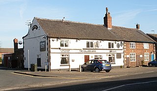
Great Boys Colliery was a coal mine operating on the Manchester Coalfield in the second half of the 19th century in Tyldesley, then in the historic county of Lancashire, England. It was sunk on Great Boys farm, which in 1778 was described as a "messuage with eight Cheshire acres of land" on the north side of Sale Lane west of the Colliers Arms public house. It was owned by William Atkin and sold in 1855 to mineowners, John Fletcher of Bolton and Samuel Scowcroft. By 1869 their partnership was dissolved and the company became John Fletcher and Sons in 1877. Shafts were sunk for a colliery on Pear Tree Farm on the corner of Mort Lane and Sale Lane which appear in the 1867 Mines Lists and became part of Great Boys Colliery. Fletcher and Schofield were granted permission to construct a mineral railway to join the London and North Western Railway's Tyldesley Loopline in 1868 but there is no evidence that it was built. The colliery closed before 1885. The colliery accessed the Brassey mine at about 170 yards and the Six Foot mine at 182 yards. The deeper coal seams were accessed by New Lester Colliery.

The Manchester Coalfield is part of the South Lancashire Coalfield, the coal seams of which were laid down in the Carboniferous Period. Some easily accessible seams were worked on a small scale from the Middle Ages, and extensively from the beginning of the Industrial Revolution in the early 19th century until the last quarter of the 20th century. The Coal Measures lie above a bed of Millstone Grit and are interspersed with sandstones, mudstones, shales, and fireclays. The Lower Coal Measures occupy the high ground of the West Pennine Moors above Bolton and are not worked in the Manchester Coalfield. The most productive of the coal measures are the lower two thirds of the Middle Coal Measures where coal is mined from seams between the Worsley Four Foot and Arley mines. The deepest and most productive collieries were to the south of the coalfield. The coalfield is affected by the northwest to southeast aligned Pendleton Fault along the Irwell Valley and the Rossendale Valley anticline. The Coal Measures generally dip towards the south and west. Numerous other smaller faults affect the coalfield. The Upper Coal Measures are not worked in the Manchester Coalfield.
Manchester Collieries was a coal mining company with headquarters in Walkden formed from a group of independent companies operating on the Manchester Coalfield in 1929. The Mining Industry Act of 1926 attempted to stem the post-war decline in coal mining and encourage independent companies to merge in order to modernise and better survive the economic conditions of the day. Robert Burrows of the Atherton company Fletcher Burrows proposed a merger of several independent companies operating to the west of Manchester. The merger was agreed and took place in March 1929.
Fletcher, Burrows and Company was a coal mining company that owned collieries and cotton mills in Atherton, Greater Manchester, England. Gibfield, Howe Bridge and Chanters collieries exploited the coal mines (seams) of the middle coal measures in the Manchester Coalfield. The Fletchers built company housing at Hindsford and a model village at Howe Bridge which included pithead baths and a social club for its workers. The company became part of Manchester Collieries in 1929. The collieries were nationalised in 1947 becoming part of the National Coal Board.
New Lester Colliery was a coal mine operating on the Manchester Coalfield from the second half of the 19th century to the first half of the 20th century in Tyldesley, then in the historic county of Lancashire, England. It was owned by James Roscoe and two shafts were sunk in about 1865 on the east side of Mort Lane on the road to Little Hulton where Roscoe had sunk the Peel Hall and New Watergate pits.
Bridgewater Collieries originated from the coal mines on the Manchester Coalfield in Worsley in the historic county of Lancashire owned by Francis Egerton, 3rd Duke of Bridgewater in the second half of the 18th century. After the Duke's death in 1803 his estate was managed by the Bridgewater Trustees until the 3rd Earl of Ellesmere inherited the estates in 1903. Bridgewater Collieries was formed in 1921 by the 4th Earl. The company merged with other prominent mining companies to form Manchester Collieries in 1929.
New Manchester or The City was an isolated mining community on the Manchester Coalfield north of Mosley Common in the Tyldesley township, England. It lies west of a boundary stone at Ellenbrook which marks the ancient boundary of the Hundreds of Salford and West Derby, the boundary of Eccles and Leigh ecclesiastical parishes, Tyldesley, Worsley and Little Hulton townships and the metropolitan districts of Wigan and Salford. The route of the Roman road from Manchester to Wigan and the Tyldesley Loopline passed south of the village. The Lancashire and Yorkshire Railway's Manchester to Southport line passed to the north.

Astley Green Colliery was a coal mine in Astley, Greater Manchester, then in the historic county of Lancashire, England. It was the last colliery to be sunk in Astley. Sinking commenced in 1908 by the Pilkington Colliery Company, a subsidiary of the Clifton and Kersley Coal Company, at the southern edge of the Manchester Coalfield, working the Middle Coal Measures where they dipped under the Permian age rocks under Chat Moss. The colliery was north of the Bridgewater Canal. In 1929 it became part of Manchester Collieries, and in 1947 was nationalised and integrated into the National Coal Board. It closed in 1970, and is now Astley Green Colliery Museum.
Gin Pit was a coal mine operating on the Lancashire Coalfield from the 1840s in Tyldesley, Greater Manchester then in the historic county of Lancashire, England. It exploited the Middle Coal Measures of the Manchester Coalfield and was situated to the south of the Tyldesley Loopline.
Cleworth Hall Colliery was a coal mine operating on the Manchester Coalfield after 1874 in Tyldesley, Greater Manchester, then in the historic county of Lancashire, England.
Peelwood Colliery was a coal mine operating on the Manchester Coalfield after 1883 in Shakerley, Tyldesley, Greater Manchester, then in the historic county of Lancashire, England.
Nelson Pit was a coal mine operating on the Manchester Coalfield from the 1830s or 1840s in Shakerley, Tyldesley, Greater Manchester, then in the historic county of Lancashire, England.
Mosley Common Colliery was a coal mine originally owned by the Bridgewater Trustees operating on the Manchester Coalfield after 1866 in Mosley Common, Greater Manchester, then in the historic county of Lancashire, England. The colliery eventually had five shafts and became the largest colliery on the Lancashire Coalfield with access to around 270 million tons of coal under the Permian rocks to the south.