Hallau
| KGS No.? | Picture | Name | Street Address | CH1903 X coordinate | CH1903 Y coordinate | Location |
|---|---|---|---|---|---|---|
| 4328 | 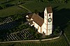 | Hilltop Church of St. Moritz | 676.742 | 284.030 | 47°42′09″N8°27′40″E / 47.702381°N 8.461044°E | |
| Unknown | ISOS Dorf: Hallau |
This list contains all cultural property of national significance (class A) in the canton of Schaffhausen from the 2009 Swiss Inventory of Cultural Property of National and Regional Significance. It is sorted by municipality and contains 47 individual buildings, 7 collections and 18 archaeological finds.
The geographic coordinates provided are in the Swiss coordinate system as given in the Inventory.
| KGS No.? | Picture | Name | Street Address | CH1903 X coordinate | CH1903 Y coordinate | Location |
|---|---|---|---|---|---|---|
| Unknown | ISOS Dorf: Dörflingen |
| KGS No.? | Picture | Name | Street Address | CH1903 X coordinate | CH1903 Y coordinate | Location |
|---|---|---|---|---|---|---|
| 9657 | Goldäcker, Neolithic Settlement | 679.200 | 283.950 | 47°42′05″N8°29′38″E / 47.701369°N 8.493774°E | ||
| Unknown | ISOS Dorf: Gächlingen |
| KGS No.? | Picture | Name | Street Address | CH1903 X coordinate | CH1903 Y coordinate | Location |
|---|---|---|---|---|---|---|
| 4328 | | Hilltop Church of St. Moritz | 676.742 | 284.030 | 47°42′09″N8°27′40″E / 47.702381°N 8.461044°E | |
| Unknown | ISOS Dorf: Hallau |
| KGS No.? | Picture | Name | Street Address | CH1903 X coordinate | CH1903 Y coordinate | Location |
|---|---|---|---|---|---|---|
| 9658 | Sankert, Iron Age Burial Mound Group | 704.350 | 282.800 | 47°41′15″N8°49′43″E / 47.687505°N 8.828503°E |
| KGS No.? | Picture | Name | Street Address | CH1903 X coordinate | CH1903 Y coordinate | Location |
|---|---|---|---|---|---|---|
| Unknown | ISOS Dorf: Lohn (SH) |
| KGS No.? | Picture | Name | Street Address | CH1903 X coordinate | CH1903 Y coordinate | Location |
|---|---|---|---|---|---|---|
| Unknown | ISOS Dorf: Löhningen |
| KGS No.? | Picture | Name | Street Address | CH1903 X coordinate | CH1903 Y coordinate | Location |
|---|---|---|---|---|---|---|
| 9736 | Parish Church's Barn | Kirchgasse | 687.640 | 290.609 | 47°45′37″N8°36′27″E / 47.760173°N 8.60752°E | |
| Unknown | ISOS Dorf: Merishausen |
| KGS No.? | Picture | Name | Street Address | CH1903 X coordinate | CH1903 Y coordinate | Location |
|---|---|---|---|---|---|---|
| 4345 |  | Villa Charlottenfels | Charlottenweg 2 | 688.795 | 282.877 | 47°41′26″N8°37′17″E / 47.69049°N 8.62137°E |
| KGS No.? | Picture | Name | Street Address | CH1903 X coordinate | CH1903 Y coordinate | Location |
|---|---|---|---|---|---|---|
| 9659 | Old City, Medieval / Early Modern City | 679.600 | 282.700 | 47°41′24″N8°29′56″E / 47.69008°N 8.498877°E | ||
| 10157 | City Walls | 679.740 | 282.800 | 47°41′27″N8°30′03″E / 47.690962°N 8.50076°E | ||
| Unknown | ISOS Kleinstadt / Flecken: Neunkirch |
| KGS No.? | Picture | Name | Street Address | CH1903 X coordinate | CH1903 Y coordinate | Location |
|---|---|---|---|---|---|---|
| 9660 | Überhürst, Neolithic Graves | 677.930 | 283.700 | 47°41′57″N8°28′37″E / 47.699273°N 8.476812°E | ||
| Unknown | ISOS Dorf: Oberhallau |
| KGS No.? | Picture | Name | Street Address | CH1903 X coordinate | CH1903 Y coordinate | Location |
|---|---|---|---|---|---|---|
| 4363 | 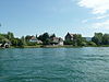 | Bibernhofgut (Mill on the Biber River) | Bibermühle 3 | 702.594 | 281.913 | 47°40′47″N8°48′18″E / 47.679807°N 8.804913°E |
| Unknown | ISOS Dorf: Ramsen | |||||
| Unknown | ISOS Spezialfall: Bibermühle |
| KGS No.? | Picture | Name | Street Address | CH1903 X coordinate | CH1903 Y coordinate | Location |
|---|---|---|---|---|---|---|
| Unknown | ISOS Dorf: Rüdlingen |
| KGS No.? | Picture | Name | Street Address | CH1903 X coordinate | CH1903 Y coordinate | Location |
|---|---|---|---|---|---|---|
| 4369 |  (Now City Administration Building) | Old Armory (Now City Administration Building) | Beckenstube 7 | 689.774 | 283.417 | 47°41′43″N8°38′04″E / 47.695212°N 8.634517°E |
| 9661 | 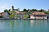 | Old City, Medieval / Early Modern City | 689.800 | 283.550 | 47°41′47″N8°38′06″E / 47.696405°N 8.634891°E | |
| 4395 | Bach School House | Bachstrasse 62 | 689.918 | 283.851 | 47°41′57″N8°38′11″E / 47.699095°N 8.636523°E | |
| 4372 | 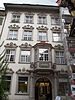 | Doppelhaus Wasserquelle and Zieglerburg | Vordergasse 26, 28 | 689.966 | 283.534 | 47°41′46″N8°38′14″E / 47.696238°N 8.637098°E |
| 4373 |  | Former Benedictine Kloster Allerheiligen Schaffhausen (German: Allerheiligen) | Münsterplatz | 689.900 | 283.400 | 47°41′42″N8°38′10″E / 47.695042°N 8.636192°E |
| 9286 | Former Kammgarnspinnerei | Baumgartenstrasse 19 | 689.898 | 283.345 | 47°41′40″N8°38′10″E / 47.694548°N 8.636154°E | |
| 4374 |  | Fronwagturm | Fronwagplatz 4 | 689.682 | 283.543 | 47°41′47″N8°38′00″E / 47.696358°N 8.633317°E |
| 9040 | Giesserei +GF+ | Werk I, Mühlentalstrasse 78 | 689.410 | 284.378 | 47°42′14″N8°37′48″E / 47.703904°N 8.629863°E | |
| 8878/extendedHtmlPopup 4376, 8878 | Grosses Haus and City Archives of Schaffhausen | Fronwagplatz 24 | 689.709 | 283.643 | 47°41′50″N8°38′01″E / 47.697254°N 8.633697°E | |
| 4404 |  | Haber House | Neustadt 51 | 689.588 | 283.430 | 47°41′43″N8°37′55″E / 47.695355°N 8.632043°E |
| 8502 |  | Hallen für neue Kunst | Baumgartenstrasse 23 | 689.846 | 283.307 | 47°41′39″N8°38′08″E / 47.694213°N 8.635454°E |
| 4377 |  | House zum Goldenen Ochsen | Vorstadt 17 | 689.722 | 283.732 | 47°41′53″N8°38′02″E / 47.698052°N 8.633889°E |
| 4378 |  | House zum Korallenbaum | Herrenacker 2 | 689.740 | 283.430 | 47°41′43″N8°38′03″E / 47.695334°N 8.634067°E |
| 4379 | House zum Luchs | Herrenacker 9 | 689.654 | 283.415 | 47°41′43″N8°37′59″E / 47.695211°N 8.632919°E | |
| 4380 |  | House zum Ritter | Vordergasse 65 | 689.797 | 283.526 | 47°41′46″N8°38′05″E / 47.696189°N 8.634846°E |
| 4381 | 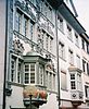 | House zum Steinbock | Oberstadt 16 | 689.622 | 283.578 | 47°41′48″N8°37′57″E / 47.696681°N 8.632525°E |
| 4382 | Herblingen, Grüthalde, Neolithic Settlement | 692.910 | 287.850 | 47°44′05″N8°40′38″E / 47.734637°N 8.677217°E | ||
| 4434 |  | Kaufleutstube | Vordergasse 58 | 689.816 | 283.600 | 47°41′49″N8°38′06″E / 47.696852°N 8.635114°E |
| 4385 | 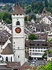 | Church of St. Johann | Vordergasse | 689.890 | 283.560 | 47°41′47″N8°38′10″E / 47.696482°N 8.636091°E |
| 8800 | Company Archives of Georg Fischer AG | Amsler-Laffon-Strasse 9 | 690.446 | 284.894 | 47°42′30″N8°38′38″E / 47.708401°N 8.64377°E | |
| 4383 |  | Korn- und Kaufhaus | Herrenacker 15 | 689.621 | 283.450 | 47°41′44″N8°37′57″E / 47.69553°N 8.632486°E |
| 11703/extendedHtmlPopup 8503, 11703 |  Cantonal Archeological Collection | Museum zu Allerheiligen and Cantonal Archeological Collection | Klosterstrasse | 689.861 | 283.390 | 47°41′42″N8°38′08″E / 47.694958°N 8.635671°E |
| 4387 |  | Rathaus (Town council house) and Archive with Schatzgewölbe | Vordergasse 73 | 689.752 | 283.513 | 47°41′46″N8°38′03″E / 47.696079°N 8.634244°E |
| 4388 |  Paleolithic Wohnhöhle | Schweizersbild, Paleolithic Wohnhöhle | 690.130 | 286.610 | 47°43′26″N8°38′24″E / 47.723875°N 8.639909°E | |
| 4389 | Sonnenburggut | Sonnenburggutstrasse 53 | 688.628 | 283.904 | 47°41′59″N8°37′10″E / 47.699748°N 8.619351°E | |
| 8817 | State Archives of Schaffhausen | Rathausbogen 4 | 689.750 | 283.480 | 47°41′45″N8°38′03″E / 47.695782°N 8.63421°E | |
| 10160 |  | City Walls | 689.000 | 283.600 | 47°41′49″N8°37′27″E / 47.696964°N 8.624245°E | |
| 9344 | 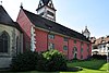 | City Library of Schaffhausen | Münsterplatz 1 | 689.962 | 283.440 | 47°41′43″N8°38′13″E / 47.695393°N 8.637026°E |
| 4392 |  | Stadthaus (Haus zur Freudenquelle) | Krummgasse 2 | 689.765 | 283.616 | 47°41′49″N8°38′04″E / 47.697003°N 8.634438°E |
| 10450 |  | Waldfriedhof | Rheinhardstrasse | 691.016 | 284.880 | 47°42′30″N8°39′05″E / 47.708197°N 8.65136°E |
| 4375 | Herrenstube Guildhouse | Fronwagplatz 3 | 689.690 | 283.539 | 47°41′47″N8°38′00″E / 47.696321°N 8.633423°E | |
| 4394 | 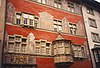 | Schmiedstube Guildhouse | Vordergasse 61 | 689.821 | 283.525 | 47°41′46″N8°38′07″E / 47.696177°N 8.635165°E |
| 4433 | 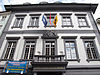 | Zum Rüden Guildhouse | Oberstadt 20 | 689.597 | 283.581 | 47°41′48″N8°37′56″E / 47.696711°N 8.632193°E |
| 4393 | 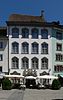 | Zur Gerberstube Guildhouse | Bachstrasse 8 | 690.067 | 283.514 | 47°41′46″N8°38′18″E / 47.696044°N 8.63844°E |
| Unknown | ISOS Stadt: Schaffhausen |
| KGS No.? | Picture | Name | Street Address | CH1903 X coordinate | CH1903 Y coordinate | Location |
|---|---|---|---|---|---|---|
| 9662 | Hebsack, Early Medieval Graves | 678.525 | 288.900 | 47°44′45″N8°29′08″E / 47.745962°N 8.485661°E | ||
| 4437 |  Roman era Vicus | Juliomagus, Roman era Vicus | 678.150 | 288.350 | 47°44′28″N8°28′50″E / 47.741061°N 8.480564°E | |
| 9663 | Vorholz, Roman era Building | 680.080 | 290.440 | 47°45′35″N8°30′24″E / 47.759622°N 8.506671°E | ||
| Unknown | ISOS Dorf: Schleitheim |
| KGS No.? | Picture | Name | Street Address | CH1903 X coordinate | CH1903 Y coordinate | Location |
|---|---|---|---|---|---|---|
| Unknown | Auf dem Stein, Early La Tène Culture (?) Graves |
| KGS No.? | Picture | Name | Street Address | CH1903 X coordinate | CH1903 Y coordinate | Location |
|---|---|---|---|---|---|---|
| 4447 |  | Hohenklingen Castle | Hohenklingen 1 | 706.622 | 280.547 | 47°40′01″N8°51′30″E / 47.666881°N 8.858216°E |
| 10554 |  Late-Roman era Castle | Burg, Late-Roman era Castle | 706.650 | 279.350 | 47°39′22″N8°51′30″E / 47.656113°N 8.858301°E | |
| 4456 |  | Former Monastery Church of St. Georg | Chirchhofplatz 10 | 706.792 | 279.656 | 47°39′32″N8°51′37″E / 47.658841°N 8.860264°E |
| 4448 |  | Former Benedictine Abbey of St. Georgen | 706.771 | 279.644 | 47°39′31″N8°51′36″E / 47.658737°N 8.859982°E | |
| 4451 | 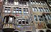 | Former Gasthaus (Combination Hotel and Restaurant) Rother Ochsen | Rathausplatz 9 | 706.707 | 279.701 | 47°39′33″N8°51′33″E / 47.65926°N 8.859144°E |
| 4449 |  | Haus Neubu | Bärengass 7 | 706.663 | 279.678 | 47°39′33″N8°51′31″E / 47.65906°N 8.858553°E |
| 4450 |  | Haus zum Lindwurm | Understadt 18 | 706.643 | 279.848 | 47°39′38″N8°51′30″E / 47.660592°N 8.858327°E |
| 4454 |  | Haus zum Weissen Adler | Oberstadt 1 | 706.754 | 279.726 | 47°39′34″N8°51′35″E / 47.659477°N 8.859775°E |
| 4455 |  | Haus zur Vorderen Krone | Rathausplatz 7 | 706.712 | 279.695 | 47°39′33″N8°51′33″E / 47.659205°N 8.859209°E |
| 4458 |  | Auf Burg Church | Hohenklingen 4 | 706.680 | 279.400 | 47°39′24″N8°51′31″E / 47.656558°N 8.858712°E |
| 4457 |  | Rathaus (Town council house) | Rathausplatz 1 | 706.749 | 279.699 | 47°39′33″N8°51′35″E / 47.659235°N 8.859702°E |
| 10162 | 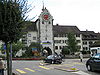 | City Fortifications | 706.700 | 279.800 | 47°39′37″N8°51′33″E / 47.660151°N 8.859074°E | |
| Unknown | ISOS Kleinstadt / Flecken: Stein am Rhein |
| KGS No.? | Picture | Name | Street Address | CH1903 X coordinate | CH1903 Y coordinate | Location |
|---|---|---|---|---|---|---|
| 4467 |  | Herblingen Castle | 691.704 | 287.715 | 47°44′01″N8°39′40″E / 47.733593°N 8.661114°E |
| KGS No.? | Picture | Name | Street Address | CH1903 X coordinate | CH1903 Y coordinate | Location |
|---|---|---|---|---|---|---|
| 4472 |  | Haus Zum Hirzen | Schulstrasse 3 | 695.357 | 289.389 | 47°44′53″N8°42′37″E / 47.748124°N 8.710164°E |
| 4473 | Haus zum Rebstock | Im Oberhof 4 | 695.503 | 289.356 | 47°44′52″N8°42′44″E / 47.747806°N 8.712104°E | |
| 4469 |  | Kesslerloch, Paleolithic Cave | 694.100 | 289.050 | 47°44′43″N8°41′36″E / 47.745257°N 8.693333°E | |
| 4468 | Weier, Neolithic Shore Front Settlement | 694.950 | 288.050 | 47°44′10″N8°42′16″E / 47.736143°N 8.70445°E | ||
| Unknown | ISOS Verstädtertes Dorf: Thayngen |
| KGS No.? | Picture | Name | Street Address | CH1903 X coordinate | CH1903 Y coordinate | Location |
|---|---|---|---|---|---|---|
| 4479 | Flühhalde, Neolithic Hilltop Settlement | 677.930 | 279.715 | 47°39′48″N8°28′34″E / 47.663438°N 8.476111°E | ||
| 4362 | Trottenhaus | Osterfingen | 678.520 | 279.800 | 47°39′51″N8°29′02″E / 47.664132°N 8.483979°E | |
| 4361 | House (with Bath) | Osterfingen | 678.534 | 278.969 | 47°39′24″N8°29′02″E / 47.656657°N 8.484019°E | |
| Unknown | ISOS Dorf: Osterfingen | |||||
| Unknown | ISOS Dorf: Wilchingen |