Altdorf
| KGS No.? | Picture | Name | Street Address | CH1903 X coordinate | CH1903 Y coordinate | Location |
|---|---|---|---|---|---|---|
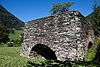
| 5772 |  | Ossuary Chapel of St. Anna | Kirchplatz 2 | 691.734 | 193.139 | 46°52′59″N8°38′32″E / 46.883038°N 8.642185°E |
| 8582 |  | Dätwyler-Stiftung | Gotthardstrasse 31 | 692.097 | 192.566 | 46°52′40″N8°38′49″E / 46.877834°N 8.646831°E |
| 5786 |  | Federal Grain Silo | Eyschachen | 691.037 | 191.692 | 46°52′12″N8°37′58″E / 46.870119°N 8.632753°E |
| 9057 | 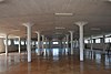 | Federal Magazine | Eyschachen | 691.010 | 191.775 | 46°52′15″N8°37′57″E / 46.870869°N 8.632415°E |
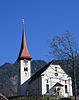
| 5775 |  | Fremdenspital with Chapel | Gemeindehausplatz 2 | 691.677 | 193.134 | 46°52′59″N8°38′29″E / 46.883001°N 8.641436°E |
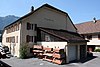
| 5789 | 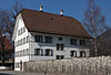 | House im Eselmätteli | Herrengasse 1 | 691.576 | 193.094 | 46°52′58″N8°38′24″E / 46.882655°N 8.640103°E |
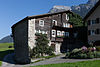
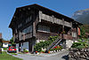
| 5776 |  | Jauch House or Suworow House | Hellgasse 9 | 692.062 | 192.877 | 46°52′50″N8°38′47″E / 46.880636°N 8.646435°E |
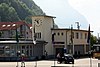
| 8579 |  | Historical Museum of Uri | Gotthardstrasse 18 | 691.955 | 192.564 | 46°52′40″N8°38′42″E / 46.877835°N 8.644968°E |
| 5778 |  | Catholic Parish Church of St. Martin | Kirchplatz | 691.730 | 193.168 | 46°53′00″N8°38′32″E / 46.883299°N 8.642138°E |
| 8791 |  | State Archives of Uri | Bahnhofstrasse 13 | 691.671 | 192.895 | 46°52′51″N8°38′29″E / 46.880852°N 8.641309°E |
| 5783 |  | Tell Monument and Türmli (Tower) | Rathausplatz | 691.872 | 192.999 | 46°52′54″N8°38′38″E / 46.881759°N 8.643967°E |
| Unknown | ISOS Stadt: Altdorf |