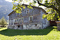
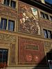
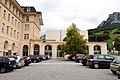
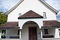
List of cultural property of national significance in Switzerland: Schwyz

Last updated

Map all coordinates using: OpenStreetMap  
Download coordinates as: KML

This list contains all cultural property of national significance (class A) in the canton of Schwyz from the 2009 Swiss Inventory of Cultural Property of National and Regional Significance. It is sorted by municipality and contains 49 individual buildings, 8 collections, 10 archaeological finds and 1 other, special site or object.

Contents

The geographic coordinates provided are in the Swiss coordinate system as given in the Inventory.

Altendorf

KGS No.?
PictureNameStreet Address CH1903 X coordinateCH1903 Y coordinateLocation
10482 Alt Rapperswil,
Castle Site
706.300226.950 47°11′06″N8°50′28″E / 47.184953°N 8.841181°E / 47.184953; 8.841181
4763
St. Johann Chapel and Sigristen House Kapelle St Johann Altendorf.jpg
St. Johann Chapel and Sigristen House
St. Johann Chapel and Sigristen HouseBurgweg 28706.300226.950 47°11′06″N8°50′28″E / 47.184953°N 8.841181°E / 47.184953; 8.841181
Unknown ISOS Weiler: Seestatt

Arth

KGS No.?
PictureNameStreet Address CH1903 X coordinateCH1903 Y coordinateLocation
11625
Alte Post Haus Arth Alte Post 3.jpg
Alte Post Haus
Alte Post HausGotthardstrasse 29683.280212.238 47°03′21″N8°32′05″E / 47.055932°N 8.534784°E / 47.055932; 8.534784
10175
High Platform of the Rigibahn Arth-Rigi-Bahn, winter.jpg
High Platform of the Rigibahn
High Platform of the Rigibahn Bahnhofstrasse684.278211.499 47°02′57″N8°32′52″E / 47.049159°N 8.54778°E / 47.049159; 8.54778
11626
Reding Chapel Arth Reding Kapelle 1.jpg
Reding Chapel
Reding ChapelGotthardstrasse 25683.224212.313 47°03′24″N8°32′03″E / 47.056614°N 8.53406°E / 47.056614; 8.53406
9673
Medieval Letzinen Letzimauer Oberarth 2.JPG
Medieval Letzinen
Medieval Letzinen683.260212.280 47°03′23″N8°32′04″E / 47.056312°N 8.534528°E / 47.056312; 8.534528
4766
Parish Church of St. Georg and Zeno Arth Pfarrkirche St. Georg und Zeno 8.jpg
Parish Church of St. Georg and Zeno
Parish Church of St. Georg and Zeno682.380213.080 47°03′49″N8°31′23″E / 47.063618°N 8.523092°E / 47.063618; 8.523092
Unknown ISOS Dorf: Arth

Einsiedeln

KGS No.?
PictureNameStreet Address CH1903 X coordinateCH1903 Y coordinateLocation
9309
Library of the Werner Oechslin Foundation Einsiedeln Bibliothek Oechslin 1.jpg
Library of the Werner Oechslin Foundation
Library of the Werner Oechslin FoundationLuegetenstrasse 11699.321220.179 47°07′31″N8°44′51″E / 47.125142°N 8.747626°E / 47.125142; 8.747626
8913, 8520/extendedHtmlPopup 4774, 8913, 8520
Einsiedeln Abbey Kloster Einsiedeln IMG 2852.JPG
Einsiedeln Abbey
Einsiedeln Abbey 699.700220.370 47°07′36″N8°45′10″E / 47.126803°N 8.752663°E / 47.126803; 8.752663
9400
Zur Ilge House Einsiedeln Haus zur Ilge.jpg
Zur Ilge House
Zur Ilge HouseSchwanenstrasse 44699.488220.303 47°07′34″N8°44′59″E / 47.126232°N 8.749854°E / 47.126232; 8.749854
4778
Meinrads Chapel and St. Meinrad Pilgrims' House Etzel Meinrad.jpg
Meinrads Chapel and St. Meinrad Pilgrims' House
Meinrads Chapel and St. Meinrad Pilgrims' House701.101225.55 47°10′23″N8°46′20″E / 47.173177°N 8.772284°E / 47.173177; 8.772284
4777
Teufelsbrucke am Etzel Teufelsbrucke1SZ.JPG
Teufelsbrücke am Etzel
Teufelsbrücke am Etzel700.730224.900 47°10′03″N8°46′02″E / 47.167388°N 8.767246°E / 47.167388; 8.767246
Unknown ISOS Kleinstadt / Flecken: Einsiedeln
Unknown ISOS ISOS Spezialfall: Etzelpass, St. Meinrad

Freienbach

KGS No.?
PictureNameStreet Address CH1903 X coordinateCH1903 Y coordinateLocation
9669
Hurden / Seedamm,
Prehistoric & Historic Bridge Seedamm rapperswil.jpg
Hurden / Seedamm,
Prehistoric & Historic Bridge
Hurden / Seedamm,
Prehistoric & Historic Bridge
703.750230.680 47°13′08″N8°48′30″E / 47.218903°N 8.808402°E / 47.218903; 8.808402
4787
Parish church of St. Peter and Paul and Martinskapelle Kirche Freienbach.JPG
Parish church of St. Peter and Paul and Martinskapelle
Parish church of St. Peter and Paul and Martinskapelle Ufnau 701.500230.540 47°13′05″N8°46′43″E / 47.217993°N 8.77867°E / 47.217993; 8.77867
8514
Seedamm Cultural Center - Pfaffikon Seedamm Kulturzentrum Pfaffikon.JPG
Seedamm Cultural Center - Pfäffikon
Seedamm Cultural Center - PfäffikonGwattstrasse 15 / Talstrasse702.710228.641 47°12′03″N8°47′39″E / 47.200728°N 8.794209°E / 47.200728; 8.794209
4788
Stiftsstatthalterei with Castle Tower and moat Schlossanlage Pfaffikon3.JPG
Stiftsstatthalterei with Castle Tower and moat
Stiftsstatthalterei with Castle Tower and moatUnterdorfstrasse701.236229.051 47°12′17″N8°46′29″E / 47.204642°N 8.774851°E / 47.204642; 8.774851
9670
Ufnau,
Prehistoric Lake Shore Settlement / Roman era temple /
Medieval settlement Insel Ufnau.JPG
Ufnau,
Prehistoric Lake Shore Settlement / Roman era temple /
Medieval settlement
Ufnau,
Prehistoric Lake Shore Settlement / Roman era temple /
Medieval settlement
701.500230.540 47°13′05″N8°46′43″E / 47.217993°N 8.77867°E / 47.217993; 8.77867
Unknown ISOS Spezialfall: Pfäffikon Unterdorf
Unknown ISOS Spezialfall: Insel Ufnau

Galgenen

KGS No.?
PictureNameStreet Address CH1903 X coordinateCH1903 Y coordinateLocation
4795
St. Jost Chapel St. Jost Galgenen 1.jpg
St. Jost Chapel
St. Jost Chapel708.791226.265 47°10′42″N8°52′26″E / 47.178387°N 8.873876°E / 47.178387; 8.873876
4794
Catholic Parish Church of St. Martin Galgenen, Katholische Pfarrkirche Sankt Martin KGS4794 foto2 2014-07-20 11.06.jpg
Catholic Parish Church of St. Martin
Catholic Parish Church of St. Martin708.820226.700 47°10′56″N8°52′28″E / 47.182294°N 8.874363°E / 47.182294; 8.874363
Unknown ISOS Verstädtertes Dorf: Siebnen Galgenen

Gersau

KGS No.?
PictureNameStreet Address CH1903 X coordinateCH1903 Y coordinateLocation
4799
Parish Church of St. Marzellus Picswiss SZ-22-06.jpg
Parish Church of St. Marzellus
Parish Church of St. MarzellusGrandstrasse682.960205.040 46°59′28″N8°31′45″E / 46.991232°N 8.529256°E / 46.991232; 8.529256
Unknown ISOS Dorf: Gersau

Ingenbohl

KGS No.?
PictureNameStreet Address CH1903 X coordinateCH1903 Y coordinateLocation
Unknown ISOS Verstädtertes Dorf: Brunnen

Küssnacht

KGS No.?
PictureNameStreet Address CH1903 X coordinateCH1903 Y coordinateLocation
4813
Ruins of the Gesslerburg Castle Kuessnacht-Gesslerburg.jpg
Ruins of the Gesslerburg Castle
Ruins of the Gesslerburg Castle Seebodenstrasse676.700215.050 47°04′55″N8°26′55″E / 47.082018°N 8.448663°E / 47.082018; 8.448663
4815
Hohle Gasse with Tell Chapel Hohle Gasse.jpeg
Hohle Gasse with Tell Chapel
Hohle Gasse with Tell ChapelHohle Gasse677.027216.231 47°05′33″N8°27′11″E / 47.092602°N 8.453169°E / 47.092602; 8.453169
Unknown ISOS Kleinstadt / Flecken: Küssnacht am Rigi
Unknown ISOS Weiler: Merlischachen

Lachen

KGS No.?
PictureNameStreet Address CH1903 X coordinateCH1903 Y coordinateLocation
4823
Catholic Parish Church of Heilig-Kreuz LachenKircheinnen.JPG
Catholic Parish Church of Heilig-Kreuz
Catholic Parish Church of Heilig-KreuzKirchplatz707.020227.790 47°11′33″N8°51′03″E / 47.192391°N 8.850879°E / 47.192391; 8.850879
Unknown ISOS Kleinstadt / Flecken: Lachen

Morschach

KGS No.?
PictureNameStreet Address CH1903 X coordinateCH1903 Y coordinateLocation
11627
Silbergasse House Silbergasse morschach.jpg
Silbergasse House
Silbergasse House690.063204.213 46°58′58″N8°37′21″E / 46.982868°N 8.622457°E / 46.982868; 8.622457
11628
Tannen House Tannen.JPG
Tannen House
Tannen House689.871201.875 46°57′43″N8°37′10″E / 46.961866°N 8.619471°E / 46.961866; 8.619471
11629
Tannen (Strabismattli) House Haus Tannen (Strabismattli) renoviert.JPG
Tannen (Sträbismattli) House
Tannen (Sträbismattli) House689.944201.854 46°57′42″N8°37′14″E / 46.961667°N 8.620426°E / 46.961667; 8.620426

Muotathal

KGS No.?
PictureNameStreet Address CH1903 X coordinateCH1903 Y coordinateLocation
4833
Catholic Parish Church of St. Sigismund and Walpurga Kirche muotathal winter.jpg
Catholic Parish Church of St. Sigismund and Walpurga
Catholic Parish Church of St. Sigismund and WalpurgaWil700.540203.770 46°58′39″N8°45′36″E / 46.97738°N 8.760048°E / 46.97738; 8.760048
Unknown ISOS Dorf: Muotathal

Rothenthurm

KGS No.?
PictureNameStreet Address CH1903 X coordinateCH1903 Y coordinateLocation
9672
Medieval Letzinen, A Watchtower Rothenthurm.4177a.JPG
Medieval Letzinen, A Watchtower
Medieval Letzinen, A Watchtower693.460217.800 47°06′17″N8°40′12″E / 47.104599°N 8.669903°E / 47.104599; 8.669903
11652
Roter Turm und Tor
(Red Tower and Gate) Rothenturm Tor01520.jpg
Roter Turm und Tor
(Red Tower and Gate)
Roter Turm und Tor
(Red Tower and Gate)
693.932217.970 47°06′22″N8°40′34″E / 47.106061°N 8.676155°E / 47.106061; 8.676155
Unknown ISOS Weiler: Biberegg

Sattel

KGS No.?
PictureNameStreet Address CH1903 X coordinateCH1903 Y coordinateLocation
9674/extendedHtmlPopup 10210, 9674
Letziturm and
Medieval Letzinen (Fortifications) Picswiss SZ-20-04.jpg
Letziturm and
Medieval Letzinen (Fortifications)
Letziturm and
Medieval Letzinen (Fortifications)
690.800216.290 47°05′29″N8°38′04″E / 47.091388°N 8.634562°E / 47.091388; 8.634562
4842
Battle of Morgarten Memorial and Chapel Morgarten-Kapelle.jpg
Battle of Morgarten Memorial and Chapel
Battle of Morgarten Memorial and ChapelÄgeristrasse690.727216.151 47°05′25″N8°38′01″E / 47.090148°N 8.633572°E / 47.090148; 8.633572
Unknown ISOS Weiler: Ecce Homo

Schübelbach

KGS No.?
PictureNameStreet Address CH1903 X coordinateCH1903 Y coordinateLocation
4848
Siebnen Powerplant Kraftwerk siebnen.jpg
Siebnen Powerplant
Siebnen PowerplantKraftwerk Wägital710.790225.550 47°10′18″N8°54′00″E / 47.171625°N 8.900066°E / 47.171625; 8.900066
Unknown ISOS Verstädtertes Dorf: Siebnen (Galgenen

Schwyz

KGS No.?
PictureNameStreet Address CH1903 X coordinateCH1903 Y coordinateLocation
4850
Bundesbriefmuseum
(Federal Charter Museum) Bundesbriefmuseum.jpg
Bundesbriefmuseum
(Federal Charter Museum)
Bundesbriefmuseum
(Federal Charter Museum)
Bahnhofstrasse 20691.965208.613 47°01′20″N8°38′54″E / 47.022181°N 8.648345°E / 47.022181; 8.648345
4858
Dominican Nuns Convent of St. Peter am Bach Frauenkloster www.f64.ch-2.jpg
Dominican Nuns Convent of St. Peter am Bach
Dominican Nuns Convent of St. Peter am BachStrehlgasse 18692.584208.374 47°01′12″N8°39′23″E / 47.019945°N 8.656437°E / 47.019945; 8.656437
9675
Village,
Medieval / Early Modern Settlement Luftaufnahme Schwyz1.jpg
Village,
Medieval / Early Modern Settlement
Village,
Medieval / Early Modern Settlement
692.500208.450 47°01′14″N8°39′19″E / 47.020641°N 8.655348°E / 47.020641; 8.655348
11689
Hermitage with Chapel,
14 Emergency Helpers and a Brothers' House Einsiedelei Schwyz www.f64.ch-1.jpg
Hermitage with Chapel,
14 Emergency Helpers and a Brothers' House
Hermitage with Chapel,
14 Emergency Helpers and a Brothers' House
Bergstrasse, Tschütschi, Rickenbach693.750208.380 47°01′11″N8°40′18″E / 47.019836°N 8.671773°E / 47.019836; 8.671773
11789
Forum der Schweizer Geschichte
(Forum of Swiss History) Forum der schweizer geschichte04.jpg
Forum der Schweizer Geschichte
(Forum of Swiss History)
Forum der Schweizer Geschichte
(Forum of Swiss History)
Hofmatt, Zeughausstrasse 5692.213208.521 47°01′17″N8°39′06″E / 47.021319°N 8.651588°E / 47.021319; 8.651588
4861
Ab Yberg im Grund House with St. Sebastian Chapel Haus Ab Yberg Schwyz 1-www.f64.ch.jpg
Ab Yberg im Grund House with St. Sebastian Chapel
Ab Yberg im Grund House with St. Sebastian ChapelGrundstrasse 82692.674207.559 47°00′45″N8°39′27″E / 47.012603°N 8.657454°E / 47.012603; 8.657454
9750
Bethlehem House Schwyz Haus Bethlehem und Grosser Mythen.jpg
Bethlehem House
Bethlehem HouseReichsstrasse 9692.474208.504 47°01′16″N8°39′18″E / 47.02113°N 8.655017°E / 47.02113; 8.655017
4862
Ceberg im Feldli House Haus Ceberg Schwyz www.f64.ch-3.jpg
Ceberg im Feldli House
Ceberg im Feldli HouseTheodosiusweg 20692.500208.880 47°01′28″N8°39′20″E / 47.024508°N 8.655436°E / 47.024508; 8.655436
11630
House Gotthardstrasse 99 www.f64.ch-1.jpg
House
HouseGotthardstrasse 99, Ibach691.705207.744 47°00′52″N8°38′41″E / 47.014401°N 8.64475°E / 47.014401; 8.64475
4860
Grosshus House Grosshus Schwyz www.f64.ch-2.jpg
Grosshus House
Grosshus HouseStrehlgasse 12692.488208.383 47°01′12″N8°39′19″E / 47.02004°N 8.655176°E / 47.02004; 8.655176
11631
Immenfeld House Haus Immenfeld Schwyz www.f64.ch-9.jpg
Immenfeld House
Immenfeld House692.995207.620 47°00′47″N8°39′42″E / 47.013106°N 8.661688°E / 47.013106; 8.661688
11632
House Langfeldweg 14 www.f64.ch-3.jpg
House
HouseLangfeldweg 14, Kaltbach691.634209.895 47°02′02″N8°38′39″E / 47.033757°N 8.644251°E / 47.033757; 8.644251
11633
House Schonenbuch Schwyz www.f64.ch-2.jpg
House
HouseOberschönenbuch 79, Ibach691.911205.844 46°59′50″N8°38′49″E / 46.997284°N 8.647074°E / 46.997284; 8.647074
4879
Herrenhaus Waldegg Waldegg Schwyz www.f64.ch-3.jpg
Herrenhaus Waldegg
Herrenhaus WaldeggWaldeggstrasse693.030207.839 47°00′54″N8°39′44″E / 47.015071°N 8.662193°E / 47.015071; 8.662193
4866
Hettlingerhauser Hettlingerhaeuser Schwyz www.f64.ch-4.jpg
Hettlingerhäuser
HettlingerhäuserRickenbachstrasse 31, 35692.625208.615 47°01′20″N8°39′25″E / 47.022107°N 8.657026°E / 47.022107; 8.657026
4852
Hofstatt Ital Reding Ital-Reding-Hofstatt Schwyz.jpg
Hofstatt Ital Reding
Hofstatt Ital RedingRickenbachstrasse 24692.539208.564 47°01′18″N8°39′21″E / 47.02166°N 8.655884°E / 47.02166; 8.655884
4853/extendedHtmlPopup 9749, 4853
Catholic Parish Church of St. Martin
with Kerchel and Heiligkreuz Chapel Kopp1august 1.JPG
Catholic Parish Church of St. Martin
with Kerchel and Heiligkreuz Chapel
Catholic Parish Church of St. Martin
with Kerchel and Heiligkreuz Chapel
Hauptplatz / Schulgasse692.360208.518 47°01′17″N8°39′13″E / 47.021272°N 8.653521°E / 47.021272; 8.653521
4873
Maihof Maihof Palais Niederoest 2-www.f64.ch.jpg
Maihof
MaihofPalais Nideröst, Schlagstrasse691.751209.265 47°01′41″N8°38′44″E / 47.028075°N 8.645662°E / 47.028075; 8.645662
4854
Palais Bueler (formerly Palais von Weber) Palais Bueeler Schwyz www.f64.ch-1.jpg
Palais Büeler (formerly Palais von Weber)
Palais Büeler (formerly Palais von Weber)Herrengasse 42691.992208.748 47°01′24″N8°38′55″E / 47.023391°N 8.648727°E / 47.023391; 8.648727
4855
Rathaus (Town council house) Schwyz Rathaus.jpg
Rathaus (Town council house)
Rathaus (Town council house)Hauptplatz 1692.387208.458 47°01′15″N8°39′14″E / 47.020728°N 8.653863°E / 47.020728; 8.653863
4876
Reding House Schwyz Hofstatt Ital Reding.jpg
Reding House
Reding HouseSchmiedgasse 6692.256208.422 47°01′14″N8°39′08″E / 47.020423°N 8.652133°E / 47.020423; 8.652133
8802
State Archives of Schwyz Staatsarchiv www.f64.ch-2.jpg
State Archives of Schwyz
State Archives of SchwyzKollegiumstrasse 30692.423208.873 47°01′28″N8°39′16″E / 47.024456°N 8.654421°E / 47.024456; 8.654421
9757
House (Koplihaus) Koeplihaus Seewen SZ 6.jpg
House (Köplihaus)
House (Köplihaus)Engiberg 4, 8690.555210.280 47°02′15″N8°37′48″E / 47.037368°N 8.630133°E / 47.037368; 8.630133
Unknown ISOS Kleinstadt / Flecken: Schwyz

Steinen

KGS No.?
PictureNameStreet Address CH1903 X coordinateCH1903 Y coordinateLocation
4884
Beinhaus Steinen Beinhaus 7.jpg
Beinhaus
BeinhausDorfplatz689.265211.680 47°03′00″N8°36′48″E / 47.050135°N 8.613438°E / 47.050135; 8.613438
11765
Former Cistercian Nuns Convent in of the Au Steinen Kapelle in der Au 2.jpg
Former Cistercian Nuns Convent in of the Au
Former Cistercian Nuns Convent in of the Au688.650210.570 47°02′25″N8°36′18″E / 47.040234°N 8.605128°E / 47.040234; 8.605128
11766
House Steinen Haus Herrengasse 11 1.jpg
House
HouseHerrengasse 11689.161211.572 47°02′57″N8°36′43″E / 47.049177°N 8.612048°E / 47.049177; 8.612048
11767
House Steinen Haus Herrengasse 15 1.jpg
House
HouseHerrengasse 15689.150211.579 47°02′57″N8°36′43″E / 47.049242°N 8.611905°E / 47.049242; 8.611905
11768
House Steinen Haus Rabengasse 17 2.jpg
House
HouseRäbengasse 17 (Feld)689.172211.139 47°02′43″N8°36′44″E / 47.045281°N 8.612108°E / 47.045281; 8.612108
Unknown ISOS Dorf: Steinen

Tuggen

KGS No.?
PictureNameStreet Address CH1903 X coordinateCH1903 Y coordinateLocation
Unknown
Grinau Tower Grynau Turm.jpg
Grinau Tower
Grinau Tower716.005230.634 47°12′59″N8°58′13″E / 47.216452°N 8.970149°E / 47.216452; 8.970149
Unknown ISOS Spezialfall: Grinau

Wangen

KGS No.?
PictureNameStreet Address CH1903 X coordinateCH1903 Y coordinateLocation
Unknown ISOS Verstädtertes Dorf: Siebnen (Galgenen

References