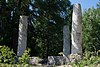
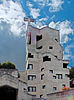
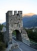
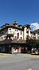
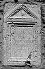
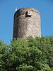
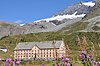
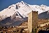
List of cultural property of national significance in Switzerland: Valais

Last updated

This list contains all cultural property of national significance (class A) in the canton of Valais from the 2009 Swiss Inventory of Cultural Property of National and Regional Significance. It is sorted by municipality and contains 58 individual buildings, 16 collections, 15 archaeological finds and 2 other, special sites or objects.

Contents

The geographic coordinates provided are in the Swiss coordinate system as given in the Inventory.

Albinen

KGS No.?
PictureNameStreet Address CH1903 X coordinateCH1903 Y coordinateLocation
Unknown ISOS Dorf: Albinen

Anniviers

KGS No.?
PictureNameStreet Address CH1903 X coordinateCH1903 Y coordinateLocation
9699
Ilot Bosquet / Chlasche Grimentz-pierre-06.jpg
Ilôt Bosquet / Chlasche
Ilôt Bosquet / Chlasche Grimentz 610.100113.250 46°10′14″N7°34′10″E / 46.170644°N 7.569413°E / 46.170644; 7.569413
Unknown ISOS village: Ayer
Unknown ISOS village: Grimentz
Unknown ISOS village: Saint-Jean
Unknown ISOS village: Vissoie
Unknown ISOS hameau: Pinsec

Bellwald

KGS No.?
PictureNameStreet Address CH1903 X coordinateCH1903 Y coordinateLocation
Unknown ISOS Weiler: Bodma

Bettmeralp

KGS No.?
PictureNameStreet Address CH1903 X coordinateCH1903 Y coordinateLocation
Unknown ISOS Weiler: Eggen

Binn

KGS No.?
PictureNameStreet Address CH1903 X coordinateCH1903 Y coordinateLocation
6629
Bogenbrucke (Bridge) with the Chapel of St. Anton CH Binn bridge.jpg
Bogenbrücke (Bridge) with the Chapel of St. Anton
Bogenbrücke (Bridge) with the Chapel of St. AntonBei der Brücke657.358135.005 46°21′50″N8°11′02″E / 46.363969°N 8.183964°E / 46.363969; 8.183964
Unknown ISOS Dorf: Schmidigehischere
Unknown ISOS Weiler: Fäld

Bitsch

KGS No.?
PictureNameStreet Address CH1903 X coordinateCH1903 Y coordinateLocation
Unknown ISOS Weiler: Wasen

Blatten

KGS No.?
PictureNameStreet Address CH1903 X coordinateCH1903 Y coordinateLocation
Unknown ISOS Dorf: Blatten
Unknown ISOS Weiler: Eisten
Unknown ISOS Weiler: Weissenried

Bourg-Saint-Pierre

KGS No.?
PictureNameStreet Address CH1903 X coordinateCH1903 Y coordinateLocation
6648
Church of St-Pierre
with romanesque Tower Bourg-Saint-Pierre church.jpg
Church of St-Pierre
with romanesque Tower
Church of St-Pierre
with romanesque Tower
582.130088.640 45°56′57″N7°12′29″E / 45.949106°N 7.208191°E / 45.949106; 7.208191
6649
Hospice with outbuildings
library, museum and archives Hospice du Grand Saint-Bernard - 2.jpg
Hospice with outbuildings
library, museum and archives
Hospice with outbuildings
library, museum and archives
Col du Grand Saint-Bernard579.196079.752 45°52′09″N7°10′15″E / 45.869073°N 7.170747°E / 45.869073; 7.170747
Unknown ISOS petite City / bourg: Bourg-Saint-Pierre
Unknown ISOS cas particulier: Grand-Saint-Bernard

Brig-Glis

KGS No.?
PictureNameStreet Address CH1903 X coordinateCH1903 Y coordinateLocation
6661
Old and New Stockalperpalast Stockalper castle.jpg
Old and New Stockalperpalast
Old and New Stockalperpalast Alte Simplonstrasse 28642.520129.468 46°18′55″N7°59′26″E / 46.315265°N 7.990656°E / 46.315265; 7.990656
6659 GamsenmauerTalsperre639.240128.000 46°18′08″N7°56′53″E / 46.30226°N 7.947951°E / 46.30226; 7.947951
6660
Church of Maria Himmelfahrt with Ossuary Wlm briga 1160.JPG
Church of Mariä Himmelfahrt with Ossuary
Church of Mariä Himmelfahrt with Ossuary 641.550128.950 46°18′38″N7°58′41″E / 46.310666°N 7.978018°E / 46.310666; 7.978018
Unknown ISOS Stadt: Brig-Glis

Bürchen

KGS No.?
PictureNameStreet Address CH1903 X coordinateCH1903 Y coordinateLocation
Unknown ISOS Spezialfall:Turtig/Wandfluh
shared between Bürchen, Raron,

Unterbäch

Chamoson

KGS No.?
PictureNameStreet Address CH1903 X coordinateCH1903 Y coordinateLocation
6682
Church of St-Pierre and Priory Eglise St-Pierre-de-Clages Suisse.jpg
Church of St-Pierre and Priory
Church of St-Pierre and Priory Rue De L’Eglise584.460115.650 46°11′32″N7°14′14″E / 46.19213°N 7.237345°E / 46.19213; 7.237345
Unknown ISOS village: Saint-Pierre de Clages

Conthey

KGS No.?
PictureNameStreet Address CH1903 X coordinateCH1903 Y coordinateLocation
Unknown ISOS cas particulier: Conthey-Bourg / Saint-Séverin

Crans-Montana

KGS No.?
PictureNameStreet Address CH1903 X coordinateCH1903 Y coordinateLocation
6853
Fairy Rock Castle (Roches Des Fees) Lower Schelter of the Rock Castle Fairy Rock in Crans Montana, Valais Switzerland, 2020.jpg
Fairy Rock Castle (Roches Des Fées)
Fairy Rock Castle (Roches Des Fées)606.280130.460 46°19′32″N7°31′13″E / 46.325505°N 7.520183°E / 46.325505; 7.520183
10361 Hotel Bella LuiMontana-Station 21602.862128.976 46°18′44″N7°28′33″E / 46.312178°N 7.475791°E / 46.312178; 7.475791

Eischoll

KGS No.?
PictureNameStreet Address CH1903 X coordinateCH1903 Y coordinateLocation
Unknown ISOS Dorf: Eischoll

Eisten

KGS No.?
PictureNameStreet Address CH1903 X coordinateCH1903 Y coordinateLocation
Unknown ISOS Village: Eisten

Ernen

KGS No.?
PictureNameStreet Address CH1903 X coordinateCH1903 Y coordinateLocation
6709
Erner Galgen Ernen-Galgen.jpg
Erner Galgen
Erner Galgen654.500139.360 46°24′12″N8°08′50″E / 46.403382°N 8.14734°E / 46.403382; 8.14734
10356 Jost-Sigristen HouseDorf654.406138.807 46°23′54″N8°08′46″E / 46.398415°N 8.146053°E / 46.398415; 8.146053
6715
Tellen House Ernen-Tellenhaus.jpg
Tellen House
Tellen HouseDorf654.390138.870 46°23′56″N8°08′45″E / 46.398983°N 8.145852°E / 46.398983; 8.145852
Unknown ISOS Village: Ernen
Unknown ISOS Village: Mühlebach

Evionnaz

KGS No.?
PictureNameStreet Address CH1903 X coordinateCH1903 Y coordinateLocation
Unknown ISOS village: Evionnaz

Evolène

KGS No.?
PictureNameStreet Address CH1903 X coordinateCH1903 Y coordinateLocation
9698
Alpage De Cotter
Prehistoric Rock Carvings Alpage de Cotter - Pierre aux immoles.jpg
Alpage De Cotter
Prehistoric Rock Carvings
Alpage De Cotter
Prehistoric Rock Carvings
606.200107.320 46°07′02″N7°31′08″E / 46.117348°N 7.518837°E / 46.117348; 7.518837
10358
Maison d'habitation RaccardEvolene.jpg
Maison d’habitation
Maison d’habitationLes Haudères604.000106.000 46°06′20″N7°29′25″E / 46.105491°N 7.490368°E / 46.105491; 7.490368
Unknown ISOS village: Evolène
Unknown ISOS village: Les Haudères
Unknown ISOS hameau: Lana

Ferden

KGS No.?
PictureNameStreet Address CH1903 X coordinateCH1903 Y coordinateLocation
10360 Rotigostadel624.600138.070 46°23′37″N7°45′30″E / 46.39354°N 7.758467°E / 46.39354; 7.758467

Finhaut

KGS No.?
PictureNameStreet Address CH1903 X coordinateCH1903 Y coordinateLocation
Unknown ISOS cas particulier: Finhaut

Fully

KGS No.?
PictureNameStreet Address CH1903 X coordinateCH1903 Y coordinateLocation
Unknown ISOS hameau: Branson

Goms

KGS No.?
PictureNameStreet Address CH1903 X coordinateCH1903 Y coordinateLocation
6878
Church of St. Maria
with Cemetery Chapel Munster - Eglise Sainte-Marie.jpg
Church of St. Maria
with Cemetery Chapel
Church of St. Maria
with Cemetery Chapel
Münster-Geschinen663.480148.750 46°29′13″N8°15′55″E / 46.487056°N 8.265391°E / 46.487056; 8.265391
6948
Church of Maria Geburt ReckingenVS1.JPG
Church of Mariä Geburt
Church of Mariä GeburtFurkastrasse, Reckingen-Gluringen661.738146.781 46°28′10″N8°14′33″E / 46.469508°N 8.242443°E / 46.469508; 8.242443
Unknown ISOS Dorf: Niederwald
Unknown ISOS Dorf: Gluringen
Unknown ISOS Dorf: Reckingen
Unknown ISOS Dorf: Biel
Unknown ISOS Dorf: Ritzingen
Unknown ISOS Dorf: Selkingen
Unknown ISOS Dorf: Geschinen
Unknown ISOS Dorf: Münster
Unknown ISOS Weiler: Ammere / Gadme /Wiler
Unknown ISOS Weiler: Bodmen

Grengiols

KGS No.?
PictureNameStreet Address CH1903 X coordinateCH1903 Y coordinateLocation
Unknown ISOS Dorf: Grengiols

Guttet-Feschel

KGS No.?
PictureNameStreet Address CH1903 X coordinateCH1903 Y coordinateLocation
Unknown ISOS Dorf: Feschel

Hérémence

KGS No.?
PictureNameStreet Address CH1903 X coordinateCH1903 Y coordinateLocation
10521
Saint-Nicolas Church, Heremence Heremence Kirche-5.jpg
Saint-Nicolas Church, Hérémence
Saint-Nicolas Church, Hérémence 597.361114.329 46°10′50″N7°24′16″E / 46.180421°N 7.404461°E / 46.180421; 7.404461
6775
aux Fees Cave Grotte aux Fees.jpg
aux Fées Cave
aux Fées Cave596.000109.830 46°08′24″N7°23′13″E / 46.139943°N 7.386874°E / 46.139943; 7.386874
9047
La Grande Dixence Dam Dixence-Staumauer.jpg
La Grande Dixence Dam
La Grande Dixence Dam597.255103.230 46°04′50″N7°24′11″E / 46.08058°N 7.403153°E / 46.08058; 7.403153
Unknown ISOS village: Hérémence
Unknown ISOS hameau: Mâche / Mâchette

Isérables

KGS No.?
PictureNameStreet Address CH1903 X coordinateCH1903 Y coordinateLocation
Unknown ISOS village: Isérables

Kippel

KGS No.?
PictureNameStreet Address CH1903 X coordinateCH1903 Y coordinateLocation
Unknown ISOS Dorf: Kippel

Lens

KGS No.?
PictureNameStreet Address CH1903 X coordinateCH1903 Y coordinateLocation
Unknown ISOS village: Lens

Leuk

KGS No.?
PictureNameStreet Address CH1903 X coordinateCH1903 Y coordinateLocation
6808
Dalaturm Dalaturm.jpg
Dalaturm
Dalaturm614.182129.490 46°19′00″N7°37′22″E / 46.316659°N 7.62276°E / 46.316659; 7.62276
6801
Church of St. Stephan Picswiss VS-69-18.jpg
Church of St. Stephan
Church of St. StephanHauptplatz 16615.125129.564 46°19′02″N7°38′06″E / 46.317304°N 7.635005°E / 46.317304; 7.635005
6802
Rathaus (Town council house) Picswiss VS-69-05.jpg
Rathaus (Town council house)
Rathaus (Town council house)Rathausplatz 1615.113129.434 46°18′58″N7°38′05″E / 46.316135°N 7.634845°E / 46.316135; 7.634845
6803
Ringacker Chapel of Maria Empfangnis
with Hermitage Picswiss VS-69-07.jpg
Ringacker Chapel of Mariä Empfängnis
with Hermitage
Ringacker Chapel of Mariä Empfängnis
with Hermitage
615.150129.190 46°18′50″N7°38′07″E / 46.313939°N 7.635317°E / 46.313939; 7.635317
6804
Zen-Ruffinen Castle / Loretan Picswiss VS-69-04.jpg
Zen-Ruffinen Castle / Loretan
Zen-Ruffinen Castle / Loretan615.037129.440 46°18′58″N7°38′02″E / 46.31619°N 7.633858°E / 46.31619; 7.633858
Unknown ISOS Kleinstadt / Flecken: Leuk
Unknown ISOS Village: Erschmatt

Leukerbad

KGS No.?
PictureNameStreet Address CH1903 X coordinateCH1903 Y coordinateLocation
6820
Gemmi Daubenwand Gemmipass.jpg
Gemmi Daubenwand
Gemmi Daubenwand613.680138.041 46°23′37″N7°36′59″E / 46.39359°N 7.616494°E / 46.39359; 7.616494

Liddes

KGS No.?
PictureNameStreet Address CH1903 X coordinateCH1903 Y coordinateLocation
6825
Les Moulins Les Moulins de Liddes (1).jpg
Les Moulins
Les Moulins579.037094.794 46°00′16″N7°10′05″E / 46.004375°N 7.168032°E / 46.004375; 7.168032
Unknown ISOS village: Liddes

Martigny

KGS No.?
PictureNameStreet Address CH1903 X coordinateCH1903 Y coordinateLocation
6831
Centre valaisan du film Mediatheque et centre valaisan du film, Martigny.jpg
Centre valaisan du film
Centre valaisan du filmAvenue du Grand-St-Bernard 4571.618105.511 46°06′02″N7°04′18″E / 46.100507°N 7.071616°E / 46.100507; 7.071616
6832
La Batiaz Castle Chateau Batiaz.jpg
La Bâtiaz Castle
La Bâtiaz Castle 571.440106.020 46°06′18″N7°04′09″E / 46.105078°N 7.069284°E / 46.105078; 7.069284
9384
Gallo-Roman Museum,
Automobile Museum,
Fondation Pierre Gianadda Fondation Gianadda.jpg
Gallo-Roman Museum,
Automobile Museum,
Fondation Pierre Gianadda
Gallo-Roman Museum,
Automobile Museum,
Fondation Pierre Gianadda
571.549104.914 46°05′42″N7°04′15″E / 46.095134°N 7.07076°E / 46.095134; 7.07076
9700
City,
Roman era and Modern City 20020809 circus 04.jpg
City,
Roman era and Modern City
City,
Roman era and Modern City
571.800105.300 46°05′55″N7°04′26″E / 46.098616°N 7.073983°E / 46.098616; 7.073983
Unknown ISOS ville: Martigny-Ville
Unknown ISOS petite City / bourg: Martigny-Bourg

Martigny-Combe

KGS No.?
PictureNameStreet Address CH1903 X coordinateCH1903 Y coordinateLocation
Unknown ISOS cas particulier: Plan Cerisier

Massongex

KGS No.?
PictureNameStreet Address CH1903 X coordinateCH1903 Y coordinateLocation
9701
Tarnaiae,
Celtic - Gallo Roman Vicus Massongex, Tarnaiae, pierre gravee.jpg
Tarnaiae,
Celtic - Gallo Roman Vicus
Tarnaiae,
Celtic - Gallo Roman Vicus
565.320121.375 46°14′34″N6°59′20″E / 46.242915°N 6.989001°E / 46.242915; 6.989001

Mont-Noble

KGS No.?
PictureNameStreet Address CH1903 X coordinateCH1903 Y coordinateLocation
Unknown ISOS village: Mase

Naters

KGS No.?
PictureNameStreet Address CH1903 X coordinateCH1903 Y coordinateLocation
6888
Ossuary Beinhaus Naters.jpg
Ossuary
Ossuary Beinhausweg642.320130.600 46°19′32″N7°59′17″E / 46.325461°N 7.988163°E / 46.325461; 7.988163
6887
Church of St. Mauritius Kirche Naters.jpg
Church of St. Mauritius
Church of St. Mauritius642.300130.615 46°19′32″N7°59′16″E / 46.325597°N 7.987905°E / 46.325597; 7.987905
Unknown ISOS Urbanized Village: Naters
Unknown ISOS Village: Blatten
Unknown ISOS Hamlet: Bodmen

Niedergesteln

KGS No.?
PictureNameStreet Address CH1903 X coordinateCH1903 Y coordinateLocation
6903
Gestelnburg Gestelnburg1.jpg
Gestelnburg
Gestelnburg626.540129.150 46°18′48″N7°46′59″E / 46.313226°N 7.78318°E / 46.313226; 7.78318
Unknown ISOS Dorf: Niedergesteln

Noble-Contrée

KGS No.?
PictureNameStreet Address CH1903 X coordinateCH1903 Y coordinateLocation
7163
Tower Chateau et eglise de Venthone.jpg
Tower
Tower 607.199128.480 46°18′28″N7°31′56″E / 46.307684°N 7.532085°E / 46.307684; 7.532085
Unknown ISOS village: Venthône

Obergoms

KGS No.?
PictureNameStreet Address CH1903 X coordinateCH1903 Y coordinateLocation
Unknown ISOS Dorf: Obergesteln
Unknown ISOS Dorf: Ulrichen
Unknown ISOS Spezialfall: Gletsch

Oberwald

KGS No.?
PictureNameStreet Address CH1903 X coordinateCH1903 Y coordinateLocation
10362
Furkabahn
Cog-Wheel Railway DFB2-Furka.jpeg
Furkabahn
Cog-Wheel Railway
Furkabahn
Cog-Wheel Railway
669.000154.000 46°32′01″N8°20′17″E / 46.533734°N 8.33806°E / 46.533734; 8.33806

Orsières

KGS No.?
PictureNameStreet Address CH1903 X coordinateCH1903 Y coordinateLocation
10447
Botanical Gardens of Alpin Flore-Alpe Jardin botanique alpin Flore-Alpe.jpg
Botanical Gardens of Alpin Flore-Alpe
Botanical Gardens of Alpin Flore-AlpeChampex574.109098.241 46°02′07″N7°06′15″E / 46.035211°N 7.104229°E / 46.035211; 7.104229
Unknown ISOS hameau: Commeire

Raron

KGS No.?
PictureNameStreet Address CH1903 X coordinateCH1903 Y coordinateLocation
6940 Heidnischbühl,
Prehistoric Site
628.600128.800 46°18′36″N7°48′36″E / 46.309993°N 7.809901°E / 46.309993; 7.809901
6936
Church of St. Roman
with old Rectory BurgkircheRaron.JPG
Church of St. Roman
with old Rectory
Church of St. Roman
with old Rectory
Burghügel628.085128.872 46°18′38″N7°48′12″E / 46.310662°N 7.80322°E / 46.310662; 7.80322
6939
Wohnturm der Viztume Wohnturm der Viztume von Raron.jpg
Wohnturm der Viztume
Wohnturm der Viztume628.126128.895 46°18′39″N7°48′14″E / 46.310867°N 7.803754°E / 46.310867; 7.803754
Unknown ISOS Dorf: Raron
Unknown ISOS Weiler: Rarner Chumma
Unknown ISOS Spezialfall:Turtig/Wandfluh
shared with Bürchen, Raron and Unterbäch

Riederalp

KGS No.?
PictureNameStreet Address CH1903 X coordinateCH1903 Y coordinateLocation
Unknown ISOS Dorf: Goppisberg
Unknown ISOS Dorf: Greich

Saas-Balen

KGS No.?
PictureNameStreet Address CH1903 X coordinateCH1903 Y coordinateLocation
6967
Church of Maria Himmelfahrt Rundkirche Saas Balen.jpg
Church of Mariä Himmelfahrt
Church of Mariä Himmelfahrt637.711111.452 46°09′13″N7°55′36″E / 46.153491°N 7.92677°E / 46.153491; 7.92677
Unknown ISOS Weiler: Bidermatten

Saillon

KGS No.?
PictureNameStreet Address CH1903 X coordinateCH1903 Y coordinateLocation
10448
Fortifications SaillonPorte.jpg
Fortifications
Fortifications580.392113.356 46°10′17″N7°11′05″E / 46.171388°N 7.184748°E / 46.171388; 7.184748
6975
Bayard Tower Tour Bayart.jpg
Bayard Tower
Bayard Tower 580.230113.260 46°10′14″N7°10′58″E / 46.17052°N 7.182654°E / 46.17052; 7.182654
Unknown ISOS petite city / bourg: Saillon

Saint-Gingolph

KGS No.?
PictureNameStreet Address CH1903 X coordinateCH1903 Y coordinateLocation
Unknown ISOS cas particulier: Saint-Gingolph

Saint-Léonard

KGS No.?
PictureNameStreet Address CH1903 X coordinateCH1903 Y coordinateLocation
9702 Crête Des Barmes,
gravures rupestres néolithiques
598.850123.700 46°15′53″N7°25′25″E / 46.264723°N 7.423721°E / 46.264723; 7.423721

Saint-Luc

KGS No.?
PictureNameStreet Address CH1903 X coordinateCH1903 Y coordinateLocation
7106
Groupe Des 5 Moulins Moulins-St-Luc-2a.jpg
Groupe Des 5 Moulins
Groupe Des 5 Moulins612.840118.360 46°13′00″N7°36′18″E / 46.216565°N 7.60503°E / 46.216565; 7.60503

Saint-Maurice

KGS No.?
PictureNameStreet Address CH1903 X coordinateCH1903 Y coordinateLocation
7114
8825
8669
9703
St-Maurice D'Agaune Abbey,
Foundation of Historical Archives,
Archeological Discoveries of the Abbey 32126 St-Maurice, Abteikirche 1990-06-03.jpg
St-Maurice D’Agaune Abbey,
Foundation of Historical Archives,
Archeological Discoveries of the Abbey
St-Maurice D’Agaune Abbey,
Foundation of Historical Archives,
Archeological Discoveries of the Abbey
566.420118.750 46°13′10″N7°00′12″E / 46.219358°N 7.003451°E / 46.219358; 7.003451
7117
8710
Castle,
Cantonal Military Museum St-Maurice-Schloss.jpg
Castle,
Cantonal Military Museum
Castle,
Cantonal Military Museum
Route du Chablais566.396119.184 46°13′24″N7°00′11″E / 46.223261°N 7.003109°E / 46.223261; 7.003109
7118
Maison de la Pierre Maisonpierre03.JPG
Maison de la Pierre
Maison de la PierreGrand-Rue 54566.527118.750 46°13′10″N7°00′17″E / 46.219364°N 7.004838°E / 46.219364; 7.004838
10365
Bridge over the Rhone,
shared with Bex, Vaud Pont sur le Rhone - Saint-Maurice.jpg
Bridge over the Rhône,
shared with Bex, Vaud
Bridge over the Rhône,
shared with Bex, Vaud
Route du Chablais / Route de Saint-Maurice566.421119.207 46°13′24″N7°00′12″E / 46.223469°N 7.003431°E / 46.223469; 7.003431
Unknown ISOS petite City / bourg: Saint-Maurice

Salvan

KGS No.?
PictureNameStreet Address CH1903 X coordinateCH1903 Y coordinateLocation
6980
Les Marecottes,
A Storage Basin for the Swiss Federal Railways KGS Les-Marecottes SBB-Bassin-(2).JPG
Les Marécottes,
A Storage Basin for the Swiss Federal Railways
Les Marécottes,
A Storage Basin for the Swiss Federal Railways
566.500106.500 46°06′33″N7°00′19″E / 46.109169°N 7.005364°E / 46.109169; 7.005364
Unknown ISOS hameau: Le Trétien

Sembrancher

KGS No.?
PictureNameStreet Address CH1903 X coordinateCH1903 Y coordinateLocation
Unknown ISOS petite City / bourg: Sembrancher

Sierre

KGS No.?
PictureNameStreet Address CH1903 X coordinateCH1903 Y coordinateLocation
7007
Centrale Electrique and Batiments Alusuisse Maison Alusuisse.jpg
Centrale Électrique and Bâtiments Alusuisse
Centrale Électrique and Bâtiments AlusuisseChippis607.850125.770 46°17′00″N7°32′26″E / 46.283299°N 7.54049°E / 46.283299; 7.54049
Unknown ISOS cas particulier: Sierre

Simplon

KGS No.?
PictureNameStreet Address CH1903 X coordinateCH1903 Y coordinateLocation
7030
Old Hospiz Hospice de Simplon.jpg
Old Hospiz
Old Hospiz644.495120.575 46°14′07″N8°00′56″E / 46.235142°N 8.015448°E / 46.235142; 8.015448
Unknown ISOS Dorf: Simplon Village
Unknown ISOS Weiler: Eggen
Unknown ISOS Spezialfall: Simplon Pass

Sion

KGS No.?
PictureNameStreet Address CH1903 X coordinateCH1903 Y coordinateLocation
8823 Archives De L’Etat Du ValaisRue Des Vergers 7593.822120.028 46°13′54″N7°21′31″E / 46.231664°N 7.358555°E / 46.231664; 7.358555
8723
8904
8903
Archives and Museum de l'Eveche de Sion
et Archives du venerable Chapitre cathedral de Sion Museum des Bistums Sitten 2013-09-17 18-06-39.jpg
Archives and Museum de l’Evêché de Sion
et Archives du vénérable Chapitre cathédral de Sion
Archives and Museum de l’Evêché de Sion
et Archives du vénérable Chapitre cathédral de Sion
Rue de la Tour 12593.801120.258 46°14′01″N7°21′30″E / 46.233732°N 7.358279°E / 46.233732; 7.358279
7035
Notre-Dame Cathedral 041122Cathedrale.jpg
Notre-Dame Cathedral
Notre-Dame Cathedral593.875120.286 46°14′02″N7°21′33″E / 46.233985°N 7.359238°E / 46.233985; 7.359238
7058
9349
Couvent des Capucins and Library Couvent des Capucins, Sion.JPG
Couvent des Capucins and Library
Couvent des Capucins and Library593.840120.700 46°14′16″N7°21′32″E / 46.237709°N 7.358779°E / 46.237709; 7.358779
7037
Church and Castle Notre-Dame de Valere Sion Valere Castle 20070730.jpg
Church and Castle Notre-Dame de Valère
Church and Castle Notre-Dame de Valère Ruelle de Tous-Vents 15594.267120.249 46°14′01″N7°21′52″E / 46.233656°N 7.36432°E / 46.233656; 7.36432
7038
Church of St-Theodule Sion, Eglise Saint-Theodule, exterieurs.jpg
Church of St-Théodule
Church of St-Théodule593.858120.236 46°14′01″N7°21′32″E / 46.233535°N 7.359018°E / 46.233535; 7.359018
7040
Hotel de Ville (City Hall) Sion city hall.JPG
Hôtel de Ville (City Hall)
Hôtel de Ville (City Hall)Rue du Grand-Pont 12593.985120.263 46°14′02″N7°21′38″E / 46.233779°N 7.360664°E / 46.233779; 7.360664
7041
La Majorie Castle Majorie.jpg
La Majorie Castle
La Majorie Castle Rue des châteaux 19594.083120.338 46°14′04″N7°21′43″E / 46.234455°N 7.361934°E / 46.234455; 7.361934
10367
Le Vidomnat Sion, le Vidomnat.jpg
Le Vidomnat
Le VidomnatPlace de la Majorie15594.033120.327 46°14′04″N7°21′41″E / 46.234355°N 7.361286°E / 46.234355; 7.361286
7042
Maison Supersaxo Sion, la Maison Supersaxo.jpg
Maison Supersaxo
Maison SupersaxoRue Supersaxo 4593.928120.208 46°14′00″N7°21′36″E / 46.233284°N 7.359926°E / 46.233284; 7.359926
9316
Mediatheque Valais Sion Mediatheque Valais.jpg
Médiathèque Valais Sion
Médiathèque Valais SionRue des Vergers 9593.822120.028 46°13′54″N7°21′31″E / 46.231664°N 7.358555°E / 46.231664; 7.358555
8721
8722
Cantonal Museum of Fine Arts and History Museum Sion, Musee cantonal des Beaux-arts.jpg
Cantonal Museum of Fine Arts and History Museum
Cantonal Museum of Fine Arts and History Museum594.075120.311 46°14′03″N7°21′43″E / 46.234212°N 7.361831°E / 46.234212; 7.361831
7044
Ruins of Tourbillon Castle Tourbillon (Sion, Schweiz 2006).JPG
Ruins of Tourbillon Castle
Ruins of Tourbillon Castle 594.470120.560 46°14′11″N7°22′01″E / 46.236455°N 7.366948°E / 46.236455; 7.366948
9704
Old City,
Neolithic and Modern City Sion, la ville, vue depuis Valere.jpg
Old City,
Neolithic and Modern City
Old City,
Neolithic and Modern City
593.600119.800 46°13′47″N7°21′20″E / 46.229611°N 7.35568°E / 46.229611; 7.35568
Unknown ISOS ville: Sion
Unknown ISOS village: Bramois

Stalden

KGS No.?
PictureNameStreet Address CH1903 X coordinateCH1903 Y coordinateLocation
7086 Kinbrücke (bridge) over the
Mattervispa with a Wayside shrine
633.370119.880 46°13′46″N7°52′16″E / 46.229533°N 7.871183°E / 46.229533; 7.871183
Unknown ISOS Dorf: Stalden (VS)
Unknown ISOS Spezialfall: Neubrück

Törbel

KGS No.?
PictureNameStreet Address CH1903 X coordinateCH1903 Y coordinateLocation
7134
Mill Muehle toerbel.jpg
Mill
MillWalke631.175120.940 46°14′21″N7°50′34″E / 46.239174°N 7.842802°E / 46.239174; 7.842802
Unknown ISOS Dorf: Törbel
Unknown ISOS Weiler: Burge
Unknown ISOS Weiler: Feld

Turtmann

KGS No.?
PictureNameStreet Address CH1903 X coordinateCH1903 Y coordinateLocation
Unknown ISOS Dorf: Turtmann

Unterbäch

KGS No.?
PictureNameStreet Address CH1903 X coordinateCH1903 Y coordinateLocation
Unknown ISOS Spezialfall:Turtig/Wandfluh
shared with Bürchen, Raron, Unterbäch

Val-d'Illiez

KGS No.?
PictureNameStreet Address CH1903 X coordinateCH1903 Y coordinateLocation
10368
Maison D'Habitation Val-d'Illiez, maison d'habitation, vue d'ensemble.jpg
Maison D’Habitation
Maison D’HabitationPlat557.560116.364 46°11′51″N6°53′20″E / 46.197395°N 6.888848°E / 46.197395; 6.888848

Val de Bagnes

KGS No.?
PictureNameStreet Address CH1903 X coordinateCH1903 Y coordinateLocation
6604
Alpage De Louvie Vieille alpage de Louvie, entre ses eboulis et son lac.jpg
Alpage De Louvie
Alpage De LouvieMauvoisin589.920100.060 46°03′07″N7°18′30″E / 46.051994°N 7.308404°E / 46.051994; 7.308404
6603
Church of St-Maurice,
Ossuary and Former Rectory Eglise du Chable.jpg
Church of St-Maurice,
Ossuary and Former Rectory
Church of St-Maurice,
Ossuary and Former Rectory
Le Châble582.230103.240 46°04′50″N7°12′32″E / 46.080441°N 7.20893°E / 46.080441; 7.20893
Unknown ISOS village: Bruson
Unknown ISOS village: Le Châble
Unknown ISOS village: Médières
Unknown ISOS village: Sarreyer
Unknown ISOS hameau: Fontenelle
Unknown ISOS village: Vollèges
Unknown ISOS hameau: Vens

Vernayaz

KGS No.?
PictureNameStreet Address CH1903 X coordinateCH1903 Y coordinateLocation
Unknown ISOS hameau: Miéville

Vionnaz

KGS No.?
PictureNameStreet Address CH1903 X coordinateCH1903 Y coordinateLocation
Unknown ISOS village: Vionnaz

Visp

KGS No.?
PictureNameStreet Address CH1903 X coordinateCH1903 Y coordinateLocation
Unknown ISOS Kleinstadt / Flecken: Visp

Visperterminen

KGS No.?
PictureNameStreet Address CH1903 X coordinateCH1903 Y coordinateLocation
9705 Oberstalden,
Bronze Age / Medieval Settlement
635.200124.600 46°16′19″N7°53′43″E / 46.271899°N 7.895259°E / 46.271899; 7.895259
Unknown ISOS Weiler: Barmüli
Unknown ISOS Weiler: Bitzinen
Unknown ISOS Weiler: Niederhäusern
Unknown ISOS Weiler: Oberstalden
Unknown ISOS Weiler: Unterstalden

Vouvry

KGS No.?
PictureNameStreet Address CH1903 X coordinateCH1903 Y coordinateLocation
Unknown ISOS village: Vouvry

Zermatt

KGS No.?
PictureNameStreet Address CH1903 X coordinateCH1903 Y coordinateLocation
9706 Hubelwäng,
Petroglyphs / Prehistoric Grinding Stones
Felszeichnungen / prähistorische622.500095.600 46°00′42″N7°43′45″E / 46.011575°N 7.729122°E / 46.011575; 7.729122

Zwischbergen

KGS No.?
PictureNameStreet Address CH1903 X coordinateCH1903 Y coordinateLocation
7229 Ruins of the Gold Mine at Gondo654.150115.400 46°11′16″N8°08′24″E / 46.187884°N 8.140004°E / 46.187884; 8.140004

See also

References