Balm bei Günsberg
| KGS No.? | Picture | Name | Street Address | CH1903 X coordinate | CH1903 Y coordinate | Location |
|---|---|---|---|---|---|---|
| 4492 |  | Ruins of Balmfluh Castle | 608.820 | 233.850 | 47°15′20″N7°33′19″E / 47.2555°N 7.555157°E |
This list contains all cultural property of national significance (class A) in the canton of Solothurn from the 2009 Swiss Inventory of Cultural Property of National and Regional Significance. It is sorted by municipality and contains 35 individual buildings, 9 collections and 17 archaeological finds.
The geographic coordinates provided are in the Swiss coordinate system as given in the Inventory.
| KGS No.? | Picture | Name | Street Address | CH1903 X coordinate | CH1903 Y coordinate | Location |
|---|---|---|---|---|---|---|
| 4486 | Burgäschisee Prehistoric Lake Shore Settlement | 617.700 | 224.250 | 47°10′08″N7°40′20″E / 47.168973°N 7.672092°E |
| KGS No.? | Picture | Name | Street Address | CH1903 X coordinate | CH1903 Y coordinate | Location |
|---|---|---|---|---|---|---|
| 4492 | | Ruins of Balmfluh Castle | 608.820 | 233.850 | 47°15′20″N7°33′19″E / 47.2555°N 7.555157°E |
| KGS No.? | Picture | Name | Street Address | CH1903 X coordinate | CH1903 Y coordinate | Location |
|---|---|---|---|---|---|---|
| 4497 |  | Ruins of Neu-Falkenstein Castle | 620.540 | 241.371 | 47°19′22″N7°42′37″E / 47.322887°N 7.710332°E | |
| Unknown | ISOS Kleinstadt / Flecken: Balsthal | |||||
| Unknown | ISOS Spezialfall: Fabrikanlage Innere Klus |
| KGS No.? | Picture | Name | Street Address | CH1903 X coordinate | CH1903 Y coordinate | Location |
|---|---|---|---|---|---|---|
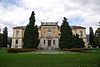
| 4506 |  | Former Benedictine Beinwil Abbey | Kloster 116 | 611.215 | 245.708 | 47°21′44″N7°35′14″E / 47.36212°N 7.587093°E |
| Unknown | ISOS Spezialfall: Monastery Beinwil |
| KGS No.? | Picture | Name | Street Address | CH1903 X coordinate | CH1903 Y coordinate | Location |
|---|---|---|---|---|---|---|
| 9666 | Inkwilersee, Paleolithic Settlement / Neolithic and Bronze Age Lake Shore Settlement | 616.949 | 227.499 | 47°11′54″N7°39′44″E / 47.198217°N 7.662309°E |
| KGS No.? | Picture | Name | Street Address | CH1903 X coordinate | CH1903 Y coordinate | Location |
|---|---|---|---|---|---|---|
| Unknown | ISOS Dorf: Aetingen | |||||
| Unknown | ISOS Dorf: Gossliwil | |||||
| Unknown | ISOS Dorf: Hessigkofen | |||||
| Unknown | ISOS Dorf: Mühledorf (SO) | |||||
| Unknown | ISOS Dorf: Tscheppach |
| KGS No.? | Picture | Name | Street Address | CH1903 X coordinate | CH1903 Y coordinate | Location |
|---|---|---|---|---|---|---|
| Unknown | (SO) ISOS Dorf: Büren |
| KGS No.? | Picture | Name | Street Address | CH1903 X coordinate | CH1903 Y coordinate | Location |
|---|---|---|---|---|---|---|
| 4527 |  Surrounding Buildings | Goetheanum with Surrounding Buildings | Hügelweg 45 | 613.695 | 259.492 | 47°29′10″N7°37′13″E / 47.486048°N 7.620344°E |
| 10167 |  | De Jaager House | Rüttiweg 20 | 613.681 | 259.346 | 47°29′05″N7°37′13″E / 47.484735°N 7.620154°E |
| 10168 |  | Duldeck House | Rüttiweg 15 | 613.572 | 259.462 | 47°29′09″N7°37′07″E / 47.485781°N 7.618711°E |
| 4526 |  | Ruins of Dorneck Castle | 614.280 | 258.820 | 47°28′48″N7°37′41″E / 47.479992°N 7.628084°E | |
| Unknown | ISOS Spezialfall: Goetheanum |
| KGS No.? | Picture | Name | Street Address | CH1903 X coordinate | CH1903 Y coordinate | Location |
|---|---|---|---|---|---|---|
| 4536 | Buechholz, Iron Age Hilltop Settlement | 644.300 | 247.900 | 47°22′50″N8°01′31″E / 47.380442°N 8.025256°E |
| KGS No.? | Picture | Name | Street Address | CH1903 X coordinate | CH1903 Y coordinate | Location |
|---|---|---|---|---|---|---|
| Unknown | ISOS Dorf: Niedererlinsbach |
| KGS No.? | Picture | Name | Street Address | CH1903 X coordinate | CH1903 Y coordinate | Location |
|---|---|---|---|---|---|---|
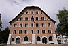
| 4539 |  | Waldegg Castle | Waldegg 1–4 | 608.315 | 230.278 | 47°13′24″N7°32′54″E / 47.223378°N 7.54842°E |
| Unknown | ISOS ISOS Spezialfall: Waldegg / Feldbrunnnen-St.Niklaus |
| KGS No.? | Picture | Name | Street Address | CH1903 X coordinate | CH1903 Y coordinate | Location |
|---|---|---|---|---|---|---|
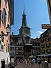
| 10170 |  | Parish Church of St. Peter and Paul | Kirchgasse 31 | 612.073 | 231.672 | 47°14′09″N7°35′53″E / 47.235859°N 7.598074°E |
| KGS No.? | Picture | Name | Street Address | CH1903 X coordinate | CH1903 Y coordinate | Location |
|---|---|---|---|---|---|---|
| Unknown | ISOS Verstädtertes Dorf: Grenchen |
| KGS No.? | Picture | Name | Street Address | CH1903 X coordinate | CH1903 Y coordinate | Location |
|---|---|---|---|---|---|---|
| 4563 |  | Kastelhöhle, Paleolithic Cave | 609.850 | 253.000 | 47°25′40″N7°34′09″E / 47.427728°N 7.569185°E |
| KGS No.? | Picture | Name | Street Address | CH1903 X coordinate | CH1903 Y coordinate | Location |
|---|---|---|---|---|---|---|
| Unknown | ISOS Dorf: Hochwald |
| KGS No.? | Picture | Name | Street Address | CH1903 X coordinate | CH1903 Y coordinate | Location |
|---|---|---|---|---|---|---|
| 4569 |  | Ruins of Alt-Bechburg Castle | 625.170 | 242.450 | 47°19′57″N7°46′18″E / 47.332432°N 7.771635°E |
| KGS No.? | Picture | Name | Street Address | CH1903 X coordinate | CH1903 Y coordinate | Location |
|---|---|---|---|---|---|---|
| Unknown | ISOS Weiler: Höngen |
| KGS No.? | Picture | Name | Street Address | CH1903 X coordinate | CH1903 Y coordinate | Location |
|---|---|---|---|---|---|---|
| Unknown | ISOS Dorf: Lüsslingen | |||||
| Unknown | ISOS Dorf: Nennigkofen |
| KGS No.? | Picture | Name | Street Address | CH1903 X coordinate | CH1903 Y coordinate | Location |
|---|---|---|---|---|---|---|
| Unknown | ISOS Dorf: Meltingen |
| KGS No.? | Picture | Name | Street Address | CH1903 X coordinate | CH1903 Y coordinate | Location |
|---|---|---|---|---|---|---|
| Unknown | ISOS Dorf: Balm bei Messen | |||||
| Unknown | ISOS Dorf: Messen |
| KGS No.? | Picture | Name | Street Address | CH1903 X coordinate | CH1903 Y coordinate | Location |
|---|---|---|---|---|---|---|
| 9307/extendedHtmlPopup 4603, 9307 |  | Benedictine Mariastein Abbey with Library | Klosterplatz 1–4 | 604.021 | 258.397 | 47°28′35″N7°29′31″E / 47.47633°N 7.491979°E |
| Unknown | ISOS Dorf: Metzerlen | |||||
| Unknown | ISOS Spezialfall: Mariastein |
| KGS No.? | Picture | Name | Street Address | CH1903 X coordinate | CH1903 Y coordinate | Location |
|---|---|---|---|---|---|---|
| Unknown | ISOS Dorf: Neuendorf |
| KGS No.? | Picture | Name | Street Address | CH1903 X coordinate | CH1903 Y coordinate | Location |
|---|---|---|---|---|---|---|
| Unknown | ISOS Dorf: Niederbuchsiten |
| KGS No.? | Picture | Name | Street Address | CH1903 X coordinate | CH1903 Y coordinate | Location |
|---|---|---|---|---|---|---|
| 10463 |  | Church and Tower | Schlossrainstrasse 9 | 641.772 | 247.033 | 47°22′22″N7°59′30″E / 47.372809°N 7.991701°E |
| Unknown | ISOS Verstädtertes Dorf: Schönenwerd |
| KGS No.? | Picture | Name | Street Address | CH1903 X coordinate | CH1903 Y coordinate | Location |
|---|---|---|---|---|---|---|
| Unknown | ISOS Dorf: Oberbuchsiten |
| KGS No.? | Picture | Name | Street Address | CH1903 X coordinate | CH1903 Y coordinate | Location |
|---|---|---|---|---|---|---|
| 4628 | Parish and Pilgrimage Church | Kirchgasse 11 | 604.870 | 230.938 | 47°13′46″N7°30′11″E / 47.229349°N 7.502943°E | |
| Unknown | ISOS Dorf: Oberdorf (SO) |
| KGS No.? | Picture | Name | Street Address | CH1903 X coordinate | CH1903 Y coordinate | Location |
|---|---|---|---|---|---|---|
| 9667 | Lehnflue, Prehistoric and Roman era Hilltop Settlement, Medieval Castle | 619.832 | 237.548 | 47°17′19″N7°42′03″E / 47.288523°N 7.700798°E | ||
| 4637 |  | Neu Bechburg Castle | 621.130 | 238.370 | 47°17′45″N7°43′05″E / 47.295876°N 7.717995°E |
| KGS No.? | Picture | Name | Street Address | CH1903 X coordinate | CH1903 Y coordinate | Location |
|---|---|---|---|---|---|---|
| 4639 |  Medieval and Early Modern City | Old City, Roman era Vicus, Medieval and Early Modern City | 635.140 | 244.440 | 47°21′00″N7°54′13″E / 47.349874°N 7.903692°E | |
| 4642 |  | Train Station | Bahnhofstrasse 22 | 635.436 | 244.679 | 47°21′07″N7°54′27″E / 47.352008°N 7.907628°E |
| 4640 | Dickenbännli, Prehistoric and Roman era Hilltop Settlement | 634.625 | 245.070 | 47°21′20″N7°53′49″E / 47.355568°N 7.896925°E | ||
| 4641 |  | Covered Wooden Bridge over the Aare River | Hauptgasse/Bahnhofquai | 635.250 | 244.400 | 47°20′58″N7°54′19″E / 47.349509°N 7.905144°E |
| 8581 | Naturmuseum | Kirchgasse 10 | 634.967 | 244.447 | 47°21′00″N7°54′05″E / 47.349946°N 7.901403°E | |
| Unknown | ISOS Kleinstadt / Flecken: Olten |
| KGS No.? | Picture | Name | Street Address | CH1903 X coordinate | CH1903 Y coordinate | Location |
|---|---|---|---|---|---|---|
| Unknown | ISOS Dorf: Rodersdorf |
| KGS No.? | Picture | Name | Street Address | CH1903 X coordinate | CH1903 Y coordinate | Location |
|---|---|---|---|---|---|---|
| 4664 | 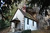 | Hermitage and Pilgrimage Site | Einsiedelei 4 | 607.243 | 230.387 | 47°13′28″N7°32′03″E / 47.224371°N 7.534268°E |
| Unknown | ISOS Spezialfall: Hermitage | |||||
| Unknown | ISOS Spezialfall: Kreuzen |
| KGS No.? | Picture | Name | Street Address | CH1903 X coordinate | CH1903 Y coordinate | Location |
|---|---|---|---|---|---|---|
| Unknown | ISOS Dorf: Schnottwil |
| KGS No.? | Picture | Name | Street Address | CH1903 X coordinate | CH1903 Y coordinate | Location |
|---|---|---|---|---|---|---|
| 9288 | Bally Areal | 642.000 | 246.000 | 47°21′49″N7°59′41″E / 47.363504°N 7.994623°E | ||
| 4669 |  | Christian Catholic Collegiate church of St. Leodegar | 642.723 | 246.930 | 47°22′19″N8°00′15″E / 47.371822°N 8.004282°E | |
| 9891 | Granary im Ballypark | Parkstrasse | 642.189 | 246.391 | 47°22′01″N7°59′50″E / 47.367008°N 7.997161°E | |
| Unknown | ISOS Verstädtertes Dorf: Schönenwerd |
| KGS No.? | Picture | Name | Street Address | CH1903 X coordinate | CH1903 Y coordinate | Location |
|---|---|---|---|---|---|---|
| 8574 | 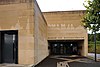 | Museum for Musikautomaten | Bollhübel 1 | 616.806 | 254.402 | 47°26′25″N7°39′41″E / 47.440196°N 7.661429°E |
| Unknown | ISOS Dorf: Seewen |
| KGS No.? | Picture | Name | Street Address | CH1903 X coordinate | CH1903 Y coordinate | Location |
|---|---|---|---|---|---|---|
| 9668 |  | Altreu, Medieval Ruined City | 600.940 | 226.600 | 47°11′25″N7°27′04″E / 47.190347°N 7.45104°E |
| KGS No.? | Picture | Name | Street Address | CH1903 X coordinate | CH1903 Y coordinate | Location |
|---|---|---|---|---|---|---|
| 4748 | Erdbeereinschlag, Iron Age Graves | 615.280 | 227.800 | 47°12′03″N7°38′25″E / 47.200965°N 7.640294°E |
| KGS No.? | Picture | Name | Street Address | CH1903 X coordinate | CH1903 Y coordinate | Location |
|---|---|---|---|---|---|---|
| 4750 |  | Ruins of Frohburg Castle (12th-14th Century) | 634.080 | 247.680 | 47°22′45″N7°53′24″E / 47.379071°N 7.88991°E |
| KGS No.? | Picture | Name | Street Address | CH1903 X coordinate | CH1903 Y coordinate | Location |
|---|---|---|---|---|---|---|
| 4755 | Käsloch, Paleolithic Cave | 636.800 | 246.200 | 47°21′56″N7°55′33″E / 47.365613°N 7.925805°E |