
The Murray River is a river in south-eastern Australia. It is Australia's longest river at 2,508 km (1,558 mi) extent. Its tributaries include five of the next six longest rivers of Australia. Together with that of the Murray, the catchments of these rivers form the Murray–Darling basin, which covers about one-seventh the area of Australia. It is widely considered Australia's most important irrigated region.

Mitta Mitta River, a perennial river and a direct tributary of the Murray River within the Murray–Darling basin, is located in the alpine district of Victoria, Australia.

The African Great Lakes are a series of lakes constituting the part of the Rift Valley lakes in and around the East African Rift. They include Lake Victoria, the third-largest fresh water lake in the world by area, Lake Tanganyika, the world's second-largest freshwater lake by volume and depth, and Lake Malawi, the world's eighth-largest fresh water lake by area. Collectively, they contain 31,000 km3 of water, which is more than either Lake Baikal or the North American Great Lakes. This total constitutes about 25% of the planet's unfrozen surface fresh water. The large rift lakes of Africa are the ancient home of great biodiversity, and 10% of the world's fish species live in this region.

The Goulburn River, a major inland perennial river of the Goulburn Broken catchment, part of the Murray-Darling basin, is located in the alpine, Northern Country/North Central, and Southern Riverina regions of the Australian state of Victoria. The headwaters of the Goulburn River rise in the western end of the Victorian Alps, below the peak of Corn Hill before descending to flow into the Murray River near Echuca, making it the longest river in Victoria at 654 kilometres (406 mi). The river is impounded by the Eildon Dam to create Lake Eildon, the Eildon Pondage, the Goulburn Weir and Waranga Basin.

The Mara River is a river in that begins in Narok County (Kenya) and in ends in Mara Region (Tanzania), and lies across the migration path of ungulates in the Maasai Mara/Serengeti ecosystem.
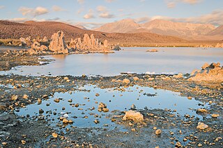
Mono Lake Tufa State Natural Reserve is located near Yosemite National Park within Mono County, in eastern California. It was established in 1981 by the California State Legislature to preserve the natural limestone "tufa tower" formations at Mono Lake.
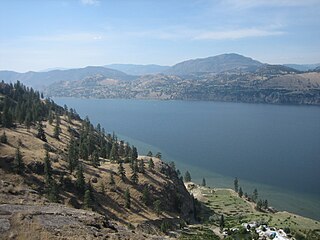
Skaha Lake, historically known as Dog Lake and, prior to that, as Lac Du Chien, is a freshwater lake located along the course of the Okanagan River in the Okanagan Valley of British Columbia, Canada. It has a surface area of approximately 20 km2, with a maximum depth of 55 metres. The lake is situated directly south of Okanagan Lake and forms the southern shoreline and boundary of the city of Penticton, British Columbia. The community of Okanagan Falls is located at its southern end, the community of Kaleden lies in the upland area to its west.

The Lake Tahoe Basin Management Unit is a United States national forest that manages and protects public land surrounding Lake Tahoe and the Lake Tahoe Basin. Straddling the state borders of California and Nevada in the Sierra Nevada, the LTBMU encompasses 154,851 acres (626 km²) of National Forest system lands, ranging in altitude above sea level from 6,225 feet at lake level to 10,881 feet at Freel Peak. The U.S. Forest Service established the LTBMU in 1973. The name of the Lake Tahoe Basin Management Unit reflects a unique sort of National Forest, as unique as the resources of the Tahoe Basin.

The Albertine Rift is the western branch of the East African Rift, covering parts of Uganda, the Democratic Republic of the Congo (DRC), Rwanda, Burundi and Tanzania. It extends from the northern end of Lake Albert to the southern end of Lake Tanganyika. The geographical term includes the valley and the surrounding mountains.

The Tambo River or Berrawan is a perennial river of the Mitchell River catchment, located in the East Gippsland region of the Australian state of Victoria. With a total length in excess of 186 kilometres (116 mi), the Tambo River is one of the longest rivers in the East Gippsland drainage basin, extending from the steep forested southern slopes of the Victorian Alps through forest and farmland to the Gippsland Lakes.

The Big River, an inland perennial river of the Goulburn Broken catchment, part of the Murray-Darling basin, is located in the lower South Eastern Highlands bioregion and Northern Country/North Central regions of the Australian state of Victoria. The headwaters of the Big River rise on the northern slopes of the Yarra Ranges and descend to flow into the Goulburn River within Lake Eildon.
The Murrindindi River, an inland perennial river of the Goulburn Broken catchment, part of the Murray-Darling basin, is located in the lower South Eastern Highlands bioregion and Northern Country/North Central regions of the Australian state of Victoria. The headwaters of the Murrindindi River rise on the western slopes of the Victorian Alps and descend to flow into the Yea River.

The Victoria Basin forest–grassland mosaic is an ecoregion that lies mostly in Uganda and extends into neighboring countries. The ecoregion is centered north and west of Lake Victoria, with an outlier on the border of Ethiopia and South Sudan.

The Yala River is a river of western Kenya, a tributary of Lake Victoria. It generally flows fast over a rocky bed through a wide valley before joining the Nzoia River to form the Yala Swamp on the border of Lake Victoria. The land along its course is mostly cultivated or used for grazing, with relatively few remnants of the original forest. Soil erosion is visible throughout the river basin, particularly in the lower parts. Projects are underway to exploit the river for hydroelectricity.