List of historical markers of the Philippines in Mimaropa

Last updated

Gate of Plaza Cuartel, Puerto Princesa City with markers in both Filipino and English Plaza Cuartel Entrance.jpg
Gate of Plaza Cuartel, Puerto Princesa City with markers in both Filipino and English

This list of historical markers installed by the National Historical Commission of the Philippines (NHCP) in Mimaropa (Region IV-B) is an annotated list of people, places, or events in the region that have been commemorated by cast-iron plaques issued by the said commission. The plaques themselves are permanent signs installed in publicly visible locations on buildings, monuments, or in special locations.

Contents

While many Cultural Properties have historical markers installed, not all places marked with historical markers are designated into one of the particular categories of Cultural Properties.

Related to the discovered shipwrecks (Japanese ship Musashi) in Sibuyan Island, Romblon, a group has been pushing the transfer of the marker Labanan sa Karagatan ng Sibuyan (Battle of Sibuyan Sea) to the said island from the town of Alcantara. [1]

This article lists thirty-nine (39) markers from the MIMAROPA Region, including four (4) that are part of the Quincentennial historical markers series.

Marinduque

This article lists fourteen (14) markers from the Province of Marinduque.

Marker titleEnglish TranslationCategoryTypeDescriptionLocationLanguageDate IssuedImage
Casa NarvasNarvas HouseBuildingHouseDeclared as a heritage house by the NHCP.BoacEnglish2007
Labanan sa PayeBattle of PayeSite of the second battle of Marinduque in the Filipino-American War.BoacFilipinoJuly 31, 1986; July 31, 2000
Ang Labanan sa Pulang Lupa Battle of Red GroundSiteSiteMonument to a successful battle of the Filipinos against the Americans in the Philippine–American War.TorrijosFilipinoSeptember 12, 1971; September 13, 2000
Liwasang KalayaanFreedom ParkWhere the document was signed which ended the Filipino-American war in MarinduqueBoacFilipinoDecember 6, 1975
Maharlikang Tahanan ni Kapitan PirokoNoble House of Captain PirocoBuildingHouseWhere locals requested that Marinduque be made a separate province. Ricardo Paras, Sr. became first governor.BoacFilipinoFebruary 23, 1973
Tanda ng Ika-sandaang Taong Pagkakatatag [2] Marker of the Hundredth Year of FoundationFormer Boac High School, now Marinduque National High School; became a garrison for the Japanese, but burned down by guerilla movements.BoacFilipinoSeptember 24, 2014
Marinduque Revolutionary ForceOrganized by Gov. Martin Lardizabal pursuant to the order of Gen. Mariano Trias after the outbreak of the Filipino-American War.TorrijosEnglishSeptember 13, 2000
Museo at Aklatan ng BoacMuseum and Library of BoacBuildingHouseSite of the oldest Catholic school in Marinduque. Rebuilt in 1987 as museum and library.BoacFilipinoNovember 30, 1987
Pilar Hidalgo Lim First woman to finish with distinction from the University of the Philippines in 1913 One of the leaders of the woman suffrage.BoacFilipinoMay 24, 1982
Puwerto ng Laylay, BoacPort of Laylay, BoacStructurePortMain port of Marinduque, used as port for ships departing for Manila and other provinces.BoacFilipinoJune 4, 2015
Ricardo M. Paras, Jr. Chief Justice of the Supreme Court. Known for his writings regarding Philippine jurisprudence.BoacFilipinoMay 30, 2005
Salvador del Mundo Leading Filipino chemist. Chief chemist of the Ceramics Laboratory of the Bureau of Science.BoacFilipinoMay 24, 1982 Salvador del Mundo Historical Marker.jpg
Simbahan ng Boac Boac ChurchBuildingHouse of WorshipBuilt in 1792. Parish priest named Saturnino Trinidad helped Colonel Maximo Abad surrender to the Americans under H.H. Bandholtz.BoacFilipinoMay 7, 1972 [3] Simbahan ng Boac.jpg
Station Balanacan
Datum Origin of the Luzon Datum of 1911
SiteGeographic centerPrimary geodetic station for the triangulation network of the Philippines; the geographical center of the PhilippinesMogpogFilipinoAugust 9, 2011

Occidental Mindoro

This article lists two (2) markers from the Province of Occidental Mindoro.

Marker titleEnglish TranslationCategoryTypeDescriptionLocationLanguageDate IssuedImage
Lumang Simbahan ng Sablayan [4] Old Church of SablayanEstablished as a Recollect parish in 1843. Damaged by a tsunami in 1877. Restored from 1877-1879.Sablayan Church, SablayanFilipinoJuly 12, 2018
Pagdaong sa MindoroMindoro LandingCommemorates the landing of the Visayan Attack Force on December 15, 1944 as well as the Filipino guerillas in Mindoro.San JoseFilipino2010

Oriental Mindoro

This article lists three (3) markers from the Province of Oriental Mindoro.

Marker titleEnglish TranslationCategoryTypeDescriptionLocationLanguageDate IssuedImage
Church of Calapan Fortified with stone wall, to watchtowers, and twenty-two cannons.CalapanEnglish1937, post-war Calapan Church historical marker.jpg
Mga Guho ng Simbahang KutaRuins of the Church-FortServed as an evacuation center during invasions. Destroyed during the Muslim invasions of 1753-1754 because of their opposition to Spanish rule.So. Kuta, Brgy. Anilao, BongabongFilipinoMay 8, 2013 [5]
Isinilang sa Pook na Ito, 10 ng Marso 1869
Macario Adriatico
Born here, March 10, 1869
Macario Adriatico
Lawyer and writer. First representative of Mindoro in the Asemblea Filipina.CalapanFilipino1949

Palawan

This article lists sixteen (16) markers from the Province of Palawan.

Marker titleEnglish TranslationCategoryTypeDescriptionLocationLanguageDate IssuedImage
Balabac

Ruta ng Ekspedisyong Magallanes - Elcano sa Pilipinas

Balabac

Route of the Magallanes - Elcano Expedition in the Philippines

This island served as a guide for the expedition towards Brunei. [6] Brgy. Poblacion V, Balabac FilipinoOctober 11, 2021 [7]
Church of St. John the Baptist [8] Church fortress finished construction in 1748. Built by the Augustinian Recollects.AgutayaEnglish
Culion Leper Colony [9] Established on August 22, 1904. Biggest leprosarium in the world during the 1920s.CulionFilipinoJuly 26, 2014
Dulo ng Palawan

Ruta ng Ekspedisyong Magallanes - Elcano sa Pilipinas

End of Palawan

Route of the Magallanes - Elcano Expedition in the Philippines

Tuan Mahamud, Palawan leader, was captured by the expedition in exchange for food.Brgy. Buliluyan, Bataraza FilipinoNovember 9, 2021 [10]
Fort Culion StructureFortificationSquare stone fort built about 1740 by Recollect-Augustinians.CulionEnglish1939
Fort Cuyo StructureFortificationFort built about 1680 by Recollect-Augustinians under the plans of Rev. Juan de San Severo, A.R..CuyoEnglish1939 Fort Cuyo historical marker 01.jpg
Fort Labo Site of Fort Labo, built in 1719 by the Recollect and Augustinians to protect the town against pirates.Labog, Sofronio Española (currently within NHCP storage)English1939 Fort Labo HistoricalMarker NHCPStorageManila.JPG
Fort of San Juan Bautista Constructed to protect the town from pirates. Maintained by the Recollect Augustinians.Lutaya, Agutaya (currently within NHCP storage)English1939 Fort of San Juan Bautista HistoricalMarker NHCPStorageManila.JPG
Higinio A. Mendoza
(1898 - 1944) [11]
Public servant and doctor. Established the Mendoza Guerilla Unit during World War II.Puerto Princesa CityFilipino2011 Historical Marker of Higinio Mendoza.JPG
Iwahig Penal Colony BuildingPenitentiaryColony established on Nov 16 1904. Originally named Iuhuit Penal Settlement.Puerto Princesa CityEnglish1954
Kutang Santa Isabel Santa Isabel FortStructureFortificationFirs built by Recollects in 1667 using wood. Main station of the pacification campaign of the Spanish in Paragua (Palawan).TaytayFilipinoApril 16, 1993

Fort Sta. Isabel Marker.JPG

Palawan

Ruta ng Ekspedisyong Magallanes - Elcano sa Pilipinas

Palawan

Route of the Magallanes - Elcano Expedition in the Philippines

From Mapun, the Magellan-Elcano expedition went to Palawan where they were first driven away by the locals. [12] Sitio Marikit, Barangay San Juan, Aborlan [13] FilipinoSeptember 22, 2021 [14]
Paglunsad sa Pulong RamosLanding at Ramos IslandWhere six Filipino radio operators and technicians landed on June 8, 1944 to ready the liberation of Palawan.BalabacFilipinoJuly 8, 1997 [15]
Plaza Cuartel StructureMilitary Structure, SiteMilitary stronghold against the Japanese in WWII and site of the Palawan massacre.Puerto PrincesaFilipino, EnglishMarch 5, 2005; English marker, April 22, 2016
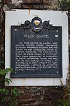
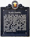
 Historical Marker at the Plaza Cuartel.JPG Plaza Cuartel NHCP historical marker (English).jpg
San Ezekiel Moreno
(1848-1906) [16]
Saint Ezekiel MorenoAugustinian Recollect priest and saint, founder of the town of Puerto Princesa. Puerto Princesa Cathedral FilipinoDecember 8, 2014
Tagusao (Dyguazam/Tegozzao)

Ruta ng Ekspedisyong Magallanes - Elcano sa Pilipinas

Tagusao

Route of the Magallanes - Elcano Expedition in the Philippines

The expedition encountered Bastiam, a trader from the Mollucas who knows Portuguese.Sitio Tagusao, Brgy. Barong-Barong, Brooke's Point FilipinoOctober 19, 2021 [17]

Romblon

This article lists four (4) markers from the Province of Romblon.

Marker titleEnglish TranslationCategoryTypeDescriptionLocationLanguageDate IssuedImage
Fort Romblon StructureFortificationFort built in 1650 under the guidance of Rev. Pedro de San Agustin, A.R.Fort San Andrés, RomblonEnglish1939
Gabriel Fabella

1898-1982

Elected as representative of Romblon in 1935. One of the founders of the Philippine Historical Association.In front of Banton Civic Center, BantonFilipinoOctober 3, 2018 [18] Gabriel Fabella historical marker (cropped).jpg
Labanan sa Karagatan ng Sibuyan Battle of the Sibuyan SeaSiteSiteOne of the greatest naval battles of WWII. Helped the American forces advance to Leyte.AlcantaraFilipino2007 Labanan sa Karagatan ng Sibuyan historical marker 2.jpg
Manuel T. Alberto y AzoresFather of the Local Autonomy Bill. Helped established the towns of Corcuera and Magdiwang.CorcueraFilipinoApril 30, 1983

See also

Related Research Articles

<span class="mw-page-title-main">Palawan</span> Province in Mimaropa, Philippines

Palawan, officially the Province of Palawan, is an archipelagic province of the Philippines that is located in the region of Mimaropa. It is the largest province in the country in terms of total area of 14,649.73 km2 (5,656.29 sq mi). The capital and largest city is Puerto Princesa wherein it is geographically grouped but administered independently from the province. Palawan is known as the Philippines' Last Frontier and as the Philippines' Best Island.

<span class="mw-page-title-main">Southern Tagalog</span> Former administrative region of the Philippines

Southern Tagalog, designated as Region IV, was an administrative region in the Philippines that comprised the current regions of Calabarzon and Mimaropa, the province of Aurora in Central Luzon, and most of the National Capital Region. It was the largest region in the Philippines in terms of both land area and population. After its partition on May 17, 2002, Southern Tagalog continues to exist as a cultural-geographical region.

<span class="mw-page-title-main">Culion</span> Municipality in Palawan, Philippines

Culion, officially the Municipality of Culion, is a 3rd class municipality in the province of Palawan, Philippines. According to the 2020 census, it has a population of 23,213 people.

<span class="mw-page-title-main">Agutaya</span> Municipality in Palawan, Philippines

Agutaya, officially the Municipality of Agutaya, is a 5th class municipality in the province of Palawan, Philippines. According to the 2020 census, it has a population of 12,867 people.

<span class="mw-page-title-main">Historical markers of the Philippines</span> Commemorative plaques in the Philippines

Historical markers are installed by the National Historical Commission of the Philippines (NHCP) and its predecessor agencies in the Philippines and places abroad that signify important and historic events, persons, structures, and institutions. The commemorative plaques are permanent signs installed by the NHCP in publicly visible locations on buildings, monuments, or in special locations. The NHCP also allows local municipalities and cities to install markers of figures and events of local significance, although these markers are barred from using the seal of the Republic of the Philippines.

<span class="mw-page-title-main">Puerto Princesa Cathedral</span> Roman Catholic church in Palawan, Philippines

The Puerto Princesa Cathedral, also known as the Immaculate Conception Cathedral Parish, is a Roman Catholic cathedral in the city of Puerto Princesa, Palawan in western Philippines. It is in the Neo-Gothic architectural tradition and is the mother church of the Apostolic Vicariate of Puerto Princesa which covers the municipalities of Palawan west of Puerto Princesa City. It is located at the border of Barangay Matiyaga Poblacion and Liwanag Poblacion, near the Port of Puerto Princesa. At 118° east longitude, it is the westernmost cathedral in the country.

References

Footnotes

  1. Cinco, Maricar. "Discovery of Japanese wreck 'surprises' Sibuyan folk" . Retrieved 2018-01-13.
  2. "NHCP unveils the Tanda ng Ika-Sandaang Taong Pagkakatatag historical marker | NATIONAL HISTORICAL COMMISSION OF THE PHILIPPINES". Archived from the original on 2014-10-06. Retrieved 2014-10-04. NHCP UNVEILS THE TANDA NG IKA-SANDAANG TAONG PAGKAKATATAG HISTORICAL MARKER
  3. National Historical Institute Annual Report 1971-1972. National Historical Institute. 1972.
  4. "Marffinn Sadaya-Tuscano Bayog Dulay". www.facebook.com. Retrieved 2018-07-15.
  5. "Archived copy" (PDF). Archived from the original (PDF) on 2013-07-24. Retrieved 2014-08-31.{{cite web}}: CS1 maint: archived copy as title (link)
  6. "National Quincentennial Committee Philippines on Twitter: "ICYMI: Two…". Twitter. Archived from the original on 2022-05-02. Retrieved 2021-10-23.
  7. @nqcPhilippines (October 13, 2021). "ICYMI: Two Quincentennial Markers were unveiled in the past few weeks in Palawan. #Palawan Marker was unveiled last 22 September at Aborlan, Palawan while the #Balabac Marker was unveiled on 11 October at Balabac, Palawan" (Tweet) via Twitter.
  8. Agutaya (2007-08-21). "iHeartAgutaya: SAVE THE FORTRESS". iHeartAgutaya. Retrieved 2018-12-03.
  9. "NHCP unveils the Culion Leper Colony historical marker | NATIONAL HISTORICAL COMMISSION OF THE PHILIPPINES". Archived from the original on 2014-09-04. Retrieved 2014-09-04. NHCP UNVEILS THE CULION LEPER COLONY HISTORICAL MARKER
  10. "Palawan Studies Center added a... - Palawan Studies Center". www.facebook.com. Retrieved 2021-11-20.
  11. http://www.puertoprincesa.ph/basicpage/city-paradise A CITY PARADISE
  12. "Log into Facebook". Facebook. Retrieved 2021-10-23.{{cite web}}: Cite uses generic title (help)
  13. Ganancial, Rachel (2021-09-26). "Magellan voyage's quincentennial marker unveiled in Palawan". PALAWAN NEWS. Retrieved 2021-10-23.
  14. "Radyo Pilipinas Palawan on Facebook". Facebook . Archived from the original on 2022-04-30.[ user-generated source ]
  15. National Historical Institute Annual Report 1997. National Historical Institute. 1997.
  16. "NHCP unveils the San Exequiel Moreno historical marker | NATIONAL HISTORICAL COMMISSION OF THE PHILIPPINES". Archived from the original on 2014-12-29. Retrieved 2014-12-29.
  17. "National Quincentennial Committee Philippines on Twitter: "ICYMI: The…". Twitter. Archived from the original on 2022-05-02. Retrieved 2021-10-23.
  18. "Gil Siegfried Fajarillo Fabella". www.facebook.com. Retrieved 2018-10-03.

Bibliography