List of historical markers of the Philippines in Eastern Visayas

Last updated

Suluan quincentennial monument and historical marker, unveiled as part of the 2021 Quincentennial Commemorations Suluan quincentennial monument and historical marker.jpg
Suluan quincentennial monument and historical marker, unveiled as part of the 2021 Quincentennial Commemorations

This list of historical markers installed by the National Historical Commission of the Philippines (NHCP) in Eastern Visayas (Region VIII) is an annotated list of people, places, or events in the region that have been commemorated by cast-iron plaques issued by the said commission. The plaques themselves are permanent signs installed in publicly visible locations on buildings, monuments, or in special locations.

Contents

While many Cultural Properties have historical markers installed, not all places marked with historical markers are designated into one of the particular categories of Cultural Properties.

This article lists fifty-one (51) markers from the Eastern Visayas Region, including four that are part of the Quincentennial historical markers series, including nine (9) that are part of the Quincentennial historical markers series.

Biliran

This article lists one (1) marker from the Province of Biliran.

Marker titleEnglish TranslationCategoryTypeDescriptionLocationLanguageDate IssuedImage
Bantayan ng Biliran Biliran WatchtowerStructureWatchtowerChurch and watchtower built from 1765 to 1774. Made from coral and stones.Brgy. San Roque, BiliranFilipinoSeptember 10, 2008

Biliran Watchtower historical marker.jpg

Leyte

This article lists twenty (20) markers from the Province of Leyte.

Marker titleEnglish TranslationCategoryTypeDescriptionLocationLanguageDate IssuedImage
Redoña House used as provisional seat of government of the Philippines. [1] Tacloban CityEnglish1959
Baybay

Ruta ng Ekspedisyong Magallanes - Elcano sa Pilipinas

Baybay

Route of the Magallanes - Elcano Expedition in the Philippines

From the waters of Canigao, the expedition went to the waters of Baybay, April 5, 1521. [2] Punta Church, Brgy. Punta, Baybay FilipinoApril 5, 2021 [3]
Canigao

Ruta ng Ekspedisyong Magallanes - Elcano sa Pilipinas

Canigao

Route of the Magallanes - Elcano Expedition in the Philippines

Antonio Pigafetta said that they went to the island of Canigao on their way to Cebu. Canigao Island, Matalom FilipinoApril 5, 2021 [3]
Capitol Building of the
Philippines, 1944-1945
[4]
BuildingGovernment CenterServed as the capitol of the Philippines and where Sergio Osmeña was formally installed as president of the Commonwealth.Leyte Provincial Capitol, Tacloban CityEnglish1950

Capitol Building of the Philippines, 1944-1945 historical marker.jpg

The Cathedral of Palo Palo CathedralBuildingHouse of WorshipFirst church built by the Jesuits; used as a hospital by American Liberation Forces.Palo Cathedral, PaloEnglish1954 The Cathedral of Palo historical marker.jpg
Church of Tanauan, LeyteBuildingHouse of WorshipFirst church built by the Jesuits in 1704. Withstood hurricane and tidal wave of 1897.TanauanEnglish1949 Tanauan Church historical marker.jpg
Don Vicente Orestes Romualdez y Lopez (1885 - 1955)Became a leader of the guerilla forces during the Japanese Occupation.Tacloban CityFilipino1985
Don Vicente Orestes Romualdez y Lopez (1885 - 1955)Became a leader of the guerilla forces during the Japanese Occupation.Daniel Z. Romualdez Memorial Elementary School, TolosaFilipino, EnglishJuly 1, 1985
Gatighan

Ruta ng Ekspedisyong Magallanes - Elcano sa Pilipinas

Gatighan

Route of the Magallanes - Elcano Expedition in the Philippines

Antonio Pigafetta noted local animals like bats and birds.Himokilan Island, Hindang FilipinoApril 5, 2021 [3]
Jaime C. De VeraBecame first Filipino governor of Leyte from 1906 to 1907. Director of the National Language Institute from 1937 to 1941.TanauanFilipinoNovember 4, 1973 Jaime C. De Veyra NHI Marker.jpg
Japanese Pillbox Whitebeach, San Jose, Tacloban CityJapanese fortification during WWII. Captured by allies and was used as shelter against Japanese air raids.Patio Victoria Beach Resort, Tacloban CityEnglish1979
Labanan sa Look ng OrmocBattle of Ormoc BaySites/EventsSitePart of the Last Allied operations in Leyte that ended in December 25, 1944.Ormoc CityFilipinoFebruary 28, 2023 Labanan sa Look ng Ormoc historical marker - NHCP.jpg
Leyte Landing McArthur landing site on October 20, 1944, to drive the Japanese out of the Philippines. MacArthur Landing Memorial National Park, PaloEnglish1949 Leyte landing historical marker.jpg
Norberto Romualdez 1875 - 1941Became a Supreme Court magistrate and a delegate to the 1934 Constitutional Convention. Site of birthplace.Ave. Maria cor. Santa Ana Sts., BurauenFilipino1975
Pagdaong sa Dulag, LeyteDulag, Leyte LandingSiteSiteSite of landing of the US 24th and 10th corps on October 20, 1944.DulagFilipino2008 Pagdaong sa Dulag, Leyte historical marker.jpg
Paglunsad sa Leyte Leyte LandingSites/EventsSite McArthur landing site on October 20, 1944. He was with President Osmeña and other government officials. MacArthur Landing Memorial National Park, PaloFilipino, English2004 Paglunsad sa Leyte historical marker.jpg
Provisional CapitolBuildingHouseBuilding was constructed in 1910. Served as provisional capitol 20–23 October 1944. Price Mansion (CAP Building), Tacloban CityEnglish1950 Provisional Capitol historical marker.jpg
Simbahan ng HilongosHilongos ChurchStarted as a visita of Ormoc. First evangelization of the Jesuits in 1603.HilongosFilipinoDecember 22, 1994 Simbahan Ng Hilongos NHCP Marker.jpg
Walter William Marquardt (1878 - 1962)Arrived in the Philippines in 1901. Principal of Philippine School of Arts and Trade.Burauen North Central School, BurauenFilipino, EnglishApril 5, 1987 Walter William Marquardt Tagalog NHI historical marker.jpg

Walter William Marquardt English NHI historical marker.jpg

The Convent of PaloConstructed by the Jesuits in 1596. Served as Leyte provincial capitol from February 1898 to March 1901.Palo Convent, Tacloban CityEnglish1954 The Convent of Palo PHC historical marker.jpg

Eastern Samar

This article lists twelve (13) markers from the Province of Eastern Samar.

Marker titleEnglish TranslationCategoryTypeDescriptionLocationLanguageDate IssuedImage
Balangiga Massacre EventSiteSite of the bloody massacre of the American forces in the span of six months.BalangigaFilipinoSeptember 28, 1982 Historical marker at the foot of Valeriano Abanador statue.JPG
Ang Labanan sa Borongan (1899 Himagsikang Pilipino–Amerikano) [5] The Battle of Borongan (1899 Philippine–American War)Where revolutionary Filipinos won in Samar under Capt. Ramon Serrano.City of BoronganFilipinoNovember 14, 2012 [6] Ang Labanan sa Borongan (1899 Himagsikang Pilipino-Amerikano) historical marker.jpg
Eugenio Daza y Salazar
(1870–1954)
Revolutionary general and lawmaker. Became representative of the Third District of Samar on the Philippine First Assembly in 1907.Real Street, Borongan poblacionFilipino1992
Eugenio Daza y Salazar
(1870–1954)
Revolutionary general and lawmaker. Became representative of the Third District of Samar on the Philippine First Assembly in 1907.Borongan–Guiuan Road, BoronganFilipinoAugust 11, 1992 Eugenio Daza NHI Historical Marker.jpg
Homonhon Where Ferdinand Magellan landed on March 17, 1521, on the feast of Saint Lazarus, which became the namesake of the Philippines.Homonhon Island, Guiuan1952
HomonhonPlace where Magellan first landed on March 17, 1521, and made contact with the natives the next day.Barangay Pagbabangnan, Homonhon, GuiuanMarch 18, 2022 Homonhon 2022 NHCP historical marker.jpg
Homonhon

Ruta ng Ekspedisyong Magallanes - Elcano sa Pilipinas

Homonhon

Route of the Magallanes - Elcano Expedition in the Philippines

SiteSiteCommemorates the 500th anniversary of the landing of the Magellan-Elcano expedition on the island on March 17, 1521.Homonhon Island, Guiuan Filipino March 17, 2021 [7] Homonhon quincentennial historical marker - NQC.jpg
Katedral ng Borongan Borongan CathedralOriginal stone church built in 1710. Became a cathedral in 1961.BoronganFilipinoSeptember 7, 1998 Katedral ng Borongan NHI Marker.jpg
Samar

Ruta ng Ekspedisyong Magallanes - Elcano sa Pilipinas

Samar

Route of the Magallanes - Elcano Expedition in the Philippines

SiteSiteCommemorates the 500th anniversary of the arrival of the Magellan-Elcano expedition in the area on March 16, 1521.Calicoan Island, Guiuan Filipino, SpanishMarch 18, 2021 [8]
Simbahan ng BalangigaChurch of BalangigaHouse of WorshipFirst built by the Jesuits in the 17th century within a fort. The bell was rung here on September 28, 1901, to signify Filipino uprising against the Americans.BalangigaFilipinoApril 3, 1993 Balangiga Church historical marker.jpg
Simbahan ng Guiuan Church of GuiuanHouse of WorshipFirst built in 1718, declared a National Cultural Treasure in 2001, destroyed by Typhoon Haiyan in 2003, then restored by the National Museum.GuiuanFilipinoMarch 18, 2021
Suluan

Ruta ng Ekspedisyong Magallanes - Elcano sa Pilipinas

Suluan

Route of the Magallanes - Elcano Expedition in the Philippines

SiteSiteCommemorates the 500th anniversary of the arrival of the Magellan-Elcano expedition in the area on March 16, 1521.Suluan Island, Guiuan Filipino March 16, 2021 Suluan quincentennial historical marker - NQC.jpg
United Nations Evacuation Center
Tubabao, Guiuan, Silangang Samar [9]
United Nations Evacuation Center
Tubabao, Guiuan, Eastern Samar
SiteSiteWhere over 6,000 Russian refugees sought asylum in the 1950s. They were accepted by President Elpidio Quirino.Tubabao Island, [10] GuiuanFilipinoNovember 16, 2016 UN Refugees in Tubabao Island Guiuan NHCP Marker.jpg

Northern Samar

This article lists seven (8) markers from the Province of Northern Samar.

Marker titleEnglish TranslationCategoryTypeDescriptionLocationLanguageDate IssuedImage
Agustin Sumuroy [11] Rebel leader against the Spaniards. Rebelled against forced labor and abuses against the natives.PalapagFilipino Agustin Sumuroy historical marker.jpg
Daungang Galyon ng Palapag, SamarGalleon Port of Palapag, SamarSitePortOne of the official ports of galleons from Mexico before departing for Cavite.PalapagFilipinoAugust 10, 2015
Padre Francisco Ignacio Alcina, S.J.

(1610–1674)

(Spanish Jesuit missionary. Published an extensive history of the Visayas.)PalapagFilipinoJuly 30, 2024 [12]
Labanan sa Catubig [11] Battle of CatubigOne of the successful battles won by Filipinos during the Philippine-American War.CatubigFilipino2007 Labanan Sa Catubig NHI Marker.jpg
Lumang Simbahan ng PalapagOld Church of PalapagBuildingHouse of WorshipRuins of the church built by the Jesuits. Established in 1605. Where the revolt of Sumuroy started.PalapagFilipinoMarch 16, 2010 Palapag Church Ruins historical marker.jpg
Parola ng Capul Capul LughthouseBuilt from 1893 to 1896. Serves as a guide for ships traversing the San Bernardino Strait.Capul Island LighthouseFilipinpOctober 24, 2018 [13]
Simbahan ng Capul Capul ChurchBuildingHouse of WorshipChurch first built by the Jesuits as a mission in 1856. Built under the patronage of Ignatius of Loyola.CapulFilipinoAugust 5, 2011 Historical Marker of Capul Church, Northern Samar.JPG
University of Eastern Philippines Pamantasan ng Silangang PilipinasUniversityInstitutionFormerly known as the Catarman Farm School.CatarmanFilipinoSeptember 12, 2014 University of Eastern Philippines NHCP Marker.jpg

Samar

This article lists two (2) markers from the Province of Samar.

Marker titleEnglish TranslationCategoryTypeDescriptionLocationLanguageDate IssuedImage
Katedral ng Calbayog [14] Calbayog CathedralEstablished by the Jesuits in 1599 as a parish of Capul. Current structure was constructed in 1840.Calbayog Church, Calbayog CityFilipinoNovember 25, 2018 Calbayog Cathedral NHCP Marker.jpg
Simbahan ng BaseyChurch of BaseyOld Jesuit parish in 1591. Transferred to the Augustinians in 1768.Basey Church facade, BaseyFilipinoSeptember 29, 1987 St Michael the Archangel Church Basey Samar Marker.jpg

Southern Leyte

This article lists seven (7) markers from the Province of Southern Leyte.

Marker titleEnglish TranslationCategoryTypeDescriptionLocationLanguageDate IssuedImage
First Mass in the Philippines Sites/EventsSiteFirst mass celebrated on Easter Sunday March 31, 1521 by Magellan and his men.LimasawaEnglish1950
First Mass in the Philippines Sites/EventsSiteFirst mass celebrated on Easter Sunday March 31, 1521 by Magellan and his men. (Replica of the marker at Limasawa.)Padre BurgosEnglishMarch 31, 1951 First Mass in the Philippines.jpg
Hinunangan

Ruta ng Ekspedisyong Magallanes - Elcano sa Pilipinas

Hinunangan

Route of the Magallanes - Elcano Expedition in the Philippines

After getting necessities from Homonhon, the expedition went to Hinunangan, March 25, 1521. [15] HinunanganFilipinoMarch 25, 2021 [16]
Katedral ng Maasin Maasin CathedralBuildingHouse of WorshipBuilt by the Jesuits in 1700. Became a cathedral on August 14, 1968, as seat of the Diocese of Maasin.Maasin CityFilipino1983 Maasin Church historical marker.jpg
Leyte

Ruta ng Ekspedisyong Magallanes - Elcano sa Pilipinas

Leyte

Route of the Magallanes - Elcano Expedition in the Philippines

From Mazaua, the expedition went northwards to Leyte.Brgy. Combado, Maasin FilipinoApril 4, 2021 [3]
Limasawa (Mazaua)

Ruta ng Ekspedisyong Magallanes - Elcano sa Pilipinas

Limasawa (Mazaua)

Route of the Magallanes - Elcano Expedition in the Philippines

Where the Magellan expedition realized that they have circled the world as Rajah Colambu and Enrique de Malacca have understood each other through the Malay language.LimasawaFilipinoMarch 31, 2021 [17]
Oppus Ancestral HouseDeclared a Heritage House on 6 October 2005.Southern Leyte Provincial Library & Information Center, Agbao, R. Kangleon St., Maasin CityEnglishApril 17, 2018 Oppus Ancestral House (Southern Leyte Provincial Library) (cropped).jpg

See also

Related Research Articles

<span class="mw-page-title-main">Leyte (province)</span> Province in Eastern Visayas, Philippines

Leyte, officially the Province of Leyte, is a province in the Philippines located in the Eastern Visayas region occupying the northern three-quarters of Leyte Island. Its capital is the city of Tacloban, administered independently from the province. Leyte is thus north of Southern Leyte, south of Biliran, and west of Samar Island. To the west across the Camotes Sea is the province of Cebu.

<span class="mw-page-title-main">Eastern Samar</span> Province in Eastern Visayas, Philippines

Eastern Samar, officially the Province of Eastern Samar, is a province in the Philippines located in the Eastern Visayas region. Its capital is the city of Borongan, which is the most populous. Eastern Samar occupies the eastern portion of the island of Samar. Bordering the province to the north is the province of Northern Samar and to the west is Samar province. To the east lies the Philippine Sea, part of the vast Pacific Ocean, while to the south lies Leyte Gulf.

<span class="mw-page-title-main">Homonhon</span> Island in Eastern Samar, Philippines

Homonhon Island is an island in the province of Eastern Samar, Philippines, on the east side of Leyte Gulf. The 20-kilometre (12 mi) long island is part of the municipality of Guiuan, encompassing eight barangays: Bitaugan, Cagusu-an, Canawayon, Casuguran, Culasi, Habag, Inapulangan, and Pagbabangnan.

<span class="mw-page-title-main">Samar</span> Third-largest island in the Philippines

Samar is the third-largest and seventh-most populous island in the Philippines, with a total population of 1,909,537 as of the 2020 census. It is located in the eastern Visayas, which are in the central Philippines. The island is divided into three provinces: Samar, Northern Samar, and Eastern Samar. These three provinces, along with the provinces on the nearby islands of Leyte and Biliran, are part of the Eastern Visayas region.

<span class="mw-page-title-main">Borongan</span> Capital of Eastern Samar, Philippines

Borongan, officially the City of Borongan, is a 1st class component city and capital of the province of Eastern Samar, Philippines. According to the 2020 census, it has a population of 71,961 people.

<span class="mw-page-title-main">Guiuan</span> Municipality in Eastern Samar, Philippines

Guiuan, officially the Municipality of Guiuan, is a 2nd class municipality in the province of Eastern Samar, Philippines. It constitutes the southeastern extremity of Samar Island and some adjacent islands, surrounded by Leyte Gulf and the Philippine Sea, two major bodies of water that makes the town the surfing capital of the Visayas. According to the 2020 census, it has a population of 53,361 people, making it the most populous municipality in Eastern Samar and the second most populous administrative division in the entire province after the capital city Borongan.

<span class="mw-page-title-main">Gibusong</span>

Gibusong, variously Hibusong and Hibuson, is a Waray-speaking island in Mindanao, Philippines, in the province of Dinagat Islands. It lies northwest of Dinagat Island, at the north end of Surigao Strait connecting with Leyte Gulf and is under the jurisdiction of the municipality of Loreto. The island, together with the smaller Little Gibusong Island, is administratively divided into three barangays: Liberty, Helene, and Magsaysay. A ferry route connects Liberty with the main port of Loreto.

<span class="mw-page-title-main">Suluan</span> Island in Eastern Samar, Philippines

Suluan is an island barangay in the Philippines, in the municipality of Guiuan, Eastern Samar. It lies east of Leyte Gulf and west of Emden Deep. The inhabitants of the island were the first Filipinos to trade and interact with Ferdinand Magellan's expedition which anchored on the nearby island of Homonhon on March 16, 1521.

The isle of Gatighan was a way station of the Armada de Molucca under Captain-General Ferdinand Magellan on their way to Cebu in Central Philippines. The location of Gatighan has not been conclusively determined.

<span class="mw-page-title-main">Historical markers of the Philippines</span> Commemorative plaques in the Philippines

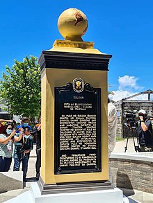
The National Historical Commission of the Philippines (NHCP) and its predecessor agencies in the Philippines and abroad installs historical markers to signify important and historic events, persons, structures, and institutions. The commemorative plaques are permanent signs installed by the NHCP in publicly visible locations on buildings, monuments, or in special locations. The NHCP also allows local municipalities and cities to install markers of figures and events of local significance, although these markers are barred from using the seal of the Republic of the Philippines.

Roderick "Derrick" Columnas Macutay is a Filipino mural artist and contemporary painter, known for his distinctive subject of surreal portraits of humans, robots, cyborgs and android like creatures and his signature color of monochrome blue usually with a vibrant accent color. His works range from mural paintings to oil paintings and illustrations.

<span class="mw-page-title-main">Guiuan Church</span> Roman Catholic church in Eastern Samar, Philippines

The Immaculate Conception Parish Church, commonly known as Guiuan Church, is a Roman Catholic church in the municipality of Guiuan, Eastern Samar, Philippines, within the jurisdiction of the Diocese of Borongan.

<span class="mw-page-title-main">First Mass in the Philippines</span> 1521 Mass during Magellans expedition

The first documented Catholic Mass in the Philippines was held on March 31, 1521, Easter Sunday. It was conducted by Father Pedro de Valderrama of Ferdinand Magellan's expedition along the shores of what was referred to in the journals of Antonio Pigafetta as "Mazaua".

<span class="mw-page-title-main">Eastern Visayas</span> Administrative region of the Philippines

Eastern Visayas is an administrative region in the Philippines, designated as Region VIII. It consists of three main islands: Samar, Leyte, and Biliran. The region has six provinces: Biliran, Leyte, Northern Samar, Samar, Eastern Samar, Southern Leyte, one independent city, Ormoc, and one highly urbanized city, Tacloban. The highly urbanized city of Tacloban is the sole regional center. These provinces and cities occupy the easternmost islands of the Visayas group of islands, hence the region's name. Some historians believe that the oldest ancient kingdom in the Philippines is found in this region, the Lakanate of Lawan, which plays a significant role in the Polynesian and Austronesian intermigration.

<span class="mw-page-title-main">Guiuan Protected Landscape and Seascape</span> Protected area in the Philippines

The Guiuan Protected Landscape and Seascape, also known as the Guiuan Marine Reserve, is a protected area associated with the Guiuan Island Group which is located off the coast of the municipality of Guiuan on the eastern side of Leyte Gulf in the Philippines. The protected area consists of the following islands from within the group: Calicoan, Manicani, Suluan, Tubabao, Victory, Homonhon and other smaller islands and their surrounding reefs. It also includes the coastal area of mainland Guiuan in Eastern Samar covering a total area of 60,448 hectares. The land which now comprises the conservation area was previously declared as a Marine Reserve and Tourist Zone and was placed under the administration and control of the Philippine Tourism Authority in 1978. It was re-proclaimed and re-classified as a protected landscape/seascape in 1994 under the National Integrated Protected Areas System Act of 1992.

<span class="mw-page-title-main">Mactan Shrine</span> Public park and memorial in Mactan, Philippines

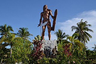
Mactan Shrine, also known as Liberty Shrine, is a memorial park on the island of Mactan in Lapu-Lapu City, Philippines. It hosts two monuments, namely the Magellan Monument, which is dedicated to Portuguese explorer Ferdinand Magellan and the Lapu Lapu Monument, a bronze statue which commemorates Lapu Lapu, a native leader who defeated Spanish soldiers led by Magellan in the 1521 Battle of Mactan.

<span class="mw-page-title-main">2021 Quincentennial Commemorations in the Philippines</span> 500th anniversary of Magellans landing and Lapu-Lapus victory

The 2021 Quincentennial Commemorations in the Philippines was a series of observances organized to mark the 500th anniversary of various events in the Philippines, notably the introduction of Christianity in the Philippines, the role of the country in the Magellan–Elcano circumnavigation, and the victory of Lapulapu in the Battle of Mactan.

References

Footnotes

  1. "Redoña House marker". Retrato: Photo archive of the Filipinas Heritage Library. Archived from the original on 2014-10-25.
  2. "National Quincentennial Committee, Republic of the Philippines - "The story of Baybay in the first circumnavigation of the world must be treated with utmost care. If you will read the account of Antonio Pigafetta, the chronicler of the Magellan-Elcano expedition, and the logbook of pilot Francisco Albo, Baybay was described as a separate island from Leyte. Pigafetta was not clear whether the expedition approached Baybay, but Albo observed how contiguous the land area was, with highlands seen from afar. "This kind of impression was not isolated to Baybay. Pigafetta, from which we rely upon much of our story in 1521, also mistakenly recorded that Hinunangan, a town in Southern Leyte province, was a separate island from mainland Leyte. Nonetheless, we cannot accuse Pigafetta or Albo of being erroneous for what they thought was true at that time for them. But how do we know? This can be answered by the science of History. "History details what actually happened based on credible sources like written accounts or recollections recorded straight from those who witnessed the event as it unfolded before their eyes. These materials known as primary sources need an expert to make sense out of them, on top of establishing their origin and understanding them, because Pigafetta's original accounts are in Italian and French, while Albo's logbook is in Spanish. Here, the expert, which we call historian, provides us a semblance of what actually happened: like when Pigafetta and Albo thought Baybay was a separate island from Leyte. But in processing what actually happened, History reminds us to be emphatic: that at that time, these people, like Magellan, had no idea of the islands of our ancestors primarily because these weren't yet included in the world map. So, here, we realize how fortunate we are to have precise Google Earth on our iPhones or Android phones. The fact of the time was that Magellan, Pigafetta, and Albo helped improved map-making in the last 500 years. It is tantamount to 500 years of understanding our home planet, and as a Filipino we will mark every place and site in the Philippines, like Baybay, to remind us and the whole world how we contributed to moving the human race forward. "On the other hand, History teaches us to think and feel like Filipino. In these quincentennial milestones, we struggle to locate ourselves in this global commemoration. Previously, when we hear Magellan and the year 1521, we always look down on ourselves as a people 'discovered' by the Europeans. This 2021, the National Quincentennial Committee aspired to enliven that Filipino in each and every one of us—that we already have culture, society, and history thousands of years before Magellan came. Our territory may be absent in the European maps, but that does not mean we are nothing. When Jose Rizal wrote Philippine History from our own lens and voice in 1889, he reminded us that "The first thing noticed by Pigafetta, who came with Magellan in 1521, on arriving [in] the Philippines... was the courtesy and kindness of the inhabitants and their commerce." Pigafetta recorded how our ancestors exhibited compassion and kindness to the starving, undernourished, dehydrated, and dying crew of Magellan during their first meeting in Homonhon. If they ignored these foreigners, maybe the Catholics have nothing to celebrate like the 500 Years of Christianity or even having this occasion in Baybay or as a nation, we cannot identify a towering event that partly inspired the founders of the Filipino nation in 1896-1899: the 500th anniversary of the Victory at Mactan, or up until now, a lot of us still believe that the earth is flat, or global network and exchanges will not come into fruition. "Let me emphasize that we can still commemorate the achievement of humanity and science in circumnavigating the earth for the first time while celebrating the memory of our ancestors and educating our own people and the foreigners of our history and identity. - Usec. Anthony Gerard Gonzales Office of the Presidential Assistant for the Visayas and Member, National Quincentennial Committee Message delivered during the unveiling of the quincentennial historical marker for Baybay, Baybay City, Leyte, 5 April 2021". Facebook.com. Retrieved 2021-10-27.
  3. 1 2 3 4 Meniano, Sarwell; Amazona, Roel (6 April 2021). "More quincentennial markers unveiled in Leyte". Philippine News Agency. Retrieved 10 April 2021.
  4. "Provincial Capitol: Leyte". harrybalais.com. November 25, 2012. Archived from the original on 2015-04-03.
  5. "Labanan Sa Borongan Marker". Facebook. 14 November 2012.[ user-generated source ]
  6. "Labanan Sa Borongan Marker". Facebook . Retrieved 27 December 2020.
  7. "PH historical body unveils first-circumnavigation marker on Homonhon". ABS-CBN News. 18 March 2021. Retrieved 18 March 2021.
  8. Morandante, Ace (18 March 2021). "Quincentennial marker unveiled on Calicoan island". ABS-CBN News. Retrieved 19 March 2021.
  9. Caspe, Mel (November 23, 2015). "Guiuan marker". The Standard. Archived from the original on 2015-11-25.
  10. GMB (Guiuan Media Bureau) (25 November 2015). "Unveiling of Historical Markers sa Tubabao Island". Facebook. Retrieved 2018-11-25.
  11. 1 2 de la Cruz, Mio Gálit (2014). Northern Samar: Our Home. Quezon City: Write It Right. ISBN   978-9-719530-510.
  12. https://www.facebook.com/nhcp1933/posts/pfbid029vwiiZYfCk8bXoKT8FqtB9ebCq9BqmP9TU3rTXz3B3fHxHyL7zPEB3pqyswuMTial [ bare URL ]
  13. "Capul Tourism". Facebook.com. Retrieved 2018-10-24.[ dead link ]
  14. "Calbayog City Tourism Office". Facebook.com. Retrieved 2018-11-23.
  15. "Water Connects Us More Than Divides Us". 2021 Quincentennial Commemorations in the Philippines. Retrieved 2021-10-27.
  16. "NQC misubo sa 2 ka historical markers". Sunstar (in Cebuano). 28 March 2021. Retrieved 10 April 2021.
  17. "NQC unveils Limasawa Quincentennial historical marker". Philippine Information Agency. Office of the Presidential Assistant for the Visayas. 1 April 2021. Retrieved 10 April 2021.

Bibliography