Related Research Articles

The national parks of New Zealand are protected natural areas administered by the Department of Conservation (DOC). The first national parks established in the country were all focused on mountain scenery. Since the 1980s the focus has been on developing a more diverse representation of New Zealand landscapes. The parks are all culturally significant and many also contain historic features. Tongariro National Park is one of the World Heritage Sites that are of both cultural and natural significance, while four of the South Island national parks form Te Wahipounamu, another World Heritage Site. There are currently 13 national parks; a 14th, Te Urewera National Park, was disestablished in 2014.

Nelson Lakes National Park is in the South Island of New Zealand, at the northern end of the Southern Alps. It was formed after the passing of the National Parks Act in 1952. It was created in 1956. The park contains beech forests, multiple lakes, snow-covered mountains and valleys created by glaciers during the ice ages.

Arthur's Pass National Park is located in the South Island of New Zealand and covers 1,185 km2 of mostly mountainous terrain. Adjacent to it lies Craigieburn Forest Park.

Richmond is a town and the seat of the Tasman District Council in New Zealand. It lies 13 kilometres (8 mi) south of Nelson in the South Island, close to the southern extremity of Tasman Bay / Te Tai-o-Aorere. The town, first settled by Europeans in 1842, was named in 1854 after the town of Richmond on Thames near London. The town has an estimated population of 18,450 as of June 2022.

Protected areas of New Zealand are areas that are in some way protected to preserve their environmental, scientific, scenic, historical, cultural or recreational value. There are about 10,000 protected areas covering about a third of the country. The method and aims of protection vary according to the importance of the resource and whether it is publicly or privately owned.
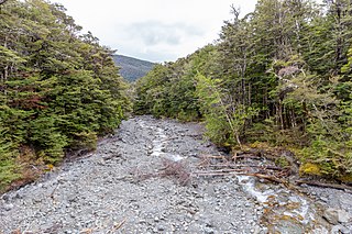
The Arnst River in New Zealand is a tributary of the Travers River, which itself flows into Lake Rotoiti, in Nelson Lakes National Park.

Torrent Bay / Rākauroa is a bay in Abel Tasman National Park, New Zealand.
The Hinemoatū / Howard River is a river of the northern South Island of New Zealand. A tributary of the Buller River, the Hinemoatū/Howard starts at the confluence of the Hodgson and Tier Streams in the Travers Range of Nelson Lakes National Park, flowing north between Lakes Rotoroa and Rotoiti, before reaching the Buller between Kawatiri and Saint Arnaud. Close to its confluence with the Buller, the river is bridged by State Highway 63 and further up by Howard Valley Road.

The Waiheke River is a river of the West Coast Region of New Zealand's South Island. It flows west from its origins on Mount Barron in the Southern Alps to reach the Ahaura River, which it forms where it joins the Tūtaekurī River, 20 kilometres northwest of Lake Sumner.

Lake Ngatu is a dune lake in the Northland Region of New Zealand. It is located to the northwest of Awanui, near Waipapakauri.

Cape Rodney-Okakari Point Marine Reserve is a 5.5 km2 (2.1 sq mi) protected area in the North Island of New Zealand.

The North Island kōkako is an endangered forest bird which is endemic to the North Island of New Zealand. It is grey in colour, with a small black mask. It has blue wattles. Because of its wattle, the bird is sometimes locally called the blue-wattled crow, although it is not a corvid.

Glenduan is a small township lying to the north of Nelson, New Zealand. It lies on the shore of Tasman Bay / Te Tai-o-Aorere between the northern end of Boulder Bank and Pepin Island.

Marybank is a suburb of Nelson, New Zealand. It lies on State Highway 6 close to the northern end of Nelson Haven, between Atawhai and Wakapuaka.
Nelson South is an inner suburb of Nelson, New Zealand. It lies to the southwest of Nelson city centre, between it and Bishopdale, close to the foot of The Grampians. The main inland route to Stoke, New Zealand, Waimea Road, is Nelson South's main road.

Mount Richmond Forest Park is a forest park in New Zealand, administered by the Department of Conservation.
Long Island-Kokomohua Marine Reserve is a marine reserve, in the Marlborough Region of New Zealand's South Island. It covers an area of 619 hectares at the entrance to the Queen Charlotte Sound in the Marlborough Sounds. It was the first marine reserve established on the South Island.
Northland Conservation Park is a group of protected areas in the Northland Region of New Zealand's North Island.

Westhaven Marine Reserve is a marine reserve covering an area of 536 hectares in the Whanganui Inlet at the top of New Zealand's South Island. It was established in 1994 and is administered by the Department of Conservation.
Maniniaro / Angelus Peak is a mountain in Nelson Lakes National Park, near the northwestern extent of New Zealand's main divide. Although it is not the tallest peak in the Angelus Ridge or the wider Travers Range, Maniniaro remains a popular tramping destination and is significant to the Ngāti Apa ki te Rā Tō iwi, who claim mana whenua within the area. According to Ngāti Apa ki te Rā Tō beliefs, the mountain is intrinsically linked with nearby Rotomaninitua / Lake Angelus, with the two both said to represent the footprints of the iwi's ancestors as they embarked on their journey back to Hawaiki. It is also near both major lakes of the national park, being roughly 6 kilometres (3.7 mi) from the southern ends of both Lakes Rotoiti and Rotoroa.
References
- ↑ "Nelson Parks and Reserves". gdc.govt.nz. Gisborne District Council.
- ↑ "DOC Places to Go - Nelson-Tasman". doc.govt.nz. Department of Conservation.