List of rivers of Orange County, California

Last updated

Map showing the main Orange County watersheds and watercourses. Orange County watershed map.png
Map showing the main Orange County watersheds and watercourses.

This is a list of rivers of Orange County, California , part of the Greater Los Angeles Area in Southern California.The Santa Ana River and San Gabriel River are the largest in Orange County; their extensive watersheds extend into neighboring Los Angeles, Riverside and San Bernardino Counties. A number of smaller streams originate in or flow largely within Orange County, chief of which are Coyote Creek, Santiago Creek, San Diego Creek, Aliso Creek, and San Juan Creek. Many streams in the area received their names from Spanish explorers in the 18th century.

Contents

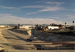
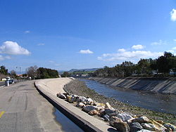
With the exception of mountain regions, Orange County is characterized by dense suburban and urban development. To protect the county's 3 million people from floods, many streams were channelized and/or lined with concrete in the 20th century. In addition, some wholly artificial streams were constructed to drain the large coastal wetlands and floodplains in north Orange County, namely in the Anaheim Bay watershed. Although the purpose of channelization is to carry floodwaters to the sea in an efficient manner, Orange County's streams have also been impacted by stormwater capture projects, to reduce the county's reliance on imported water. Such projects range from Irvine Lake – the county's largest body of fresh water, created by damming Santiago Creek in 1931 – to the extensive Santa Ana River groundwater recharge operations that provide as much as half the domestic water used in the county.

WatershedTotal
area
Area within
Orange County
%Total OC
land area
Aliso Creek [1] 22,400 acres
(91 km2)
22,400 acres
(91 km2)
4.38%
Anaheim Bay
Huntington Harbor [2]
51,422 acres
(208 km2)
51,422 acres
(208 km2)
10.06%
Newport Bay [3] 97,293 acres
(394 km2)
97,293 acres
(394 km2)
19.02%
San Gabriel River [4] [5] 440,960 acres
(1,786 km2)
53,760 acres
(218 km2)
10.51%
San Juan Creek [6] [7] 112,640 acres
(456 km2)
102,387 acres
(415 km2)
20.02%
San Mateo Creek [8] [9] 88,960 acres
(360 km2)
12,262 acres
(50 km2)
2.39%
Santa Ana River [10] [11] 1,696,000 acres
(6,869 km2)
134,701 acres
(546 km2)
26.34%

San Gabriel River watershed

North Fork Coyote Creek in La Mirada Coyote Creek (San Gabriel River).jpg
North Fork Coyote Creek in La Mirada

The San Gabriel River flows mainly in Los Angeles County, and forms part of the border between Orange and Los Angeles Counties.

Anaheim Bay watershed

Santa Ana River watershed

Huntington Beach and the Huntington Beach Channel Huntington Beach CA Aerial by Don Ramey Logan.jpg
Huntington Beach and the Huntington Beach Channel
Santa Ana River in Orange Santa Ana River (20140426-0356).JPG
Santa Ana River in Orange

The 100-mile (160 km)-long Santa Ana River begins in San Bernardino County and flows through Riverside County before bisecting northern Orange County.

Newport Bay watershed

San Diego Creek in Irvine 20140629-0185 San Diego Creek at Alton Pkwy.JPG
San Diego Creek in Irvine

Aliso Creek watershed

Aliso Creek at Laguna Beach Aliso Creek Mouth.JPG
Aliso Creek at Laguna Beach

San Juan Creek watershed

San Juan Creek in San Juan Capistrano San Juan Creek in San Juan Capistrano.JPG
San Juan Creek in San Juan Capistrano

San Mateo Creek watershed

San Mateo Creek is mostly in Riverside and San Diego Counties, with only a small portion in Orange County; however, some of its tributaries extend into Orange County.

Coastal streams

A number of smaller streams flow into the Pacific Ocean along the Orange County coast. They are listed below from north to south. Waterways indicated in the above lists are italicized, to clarify location:

Notes

  1. The Talbert watershed would naturally have drained into Santa Ana River but a separate artificial ocean outlet, just to the west of the Santa Ana River mouth, was constructed in the early 1900s.

Related Research Articles

<span class="mw-page-title-main">Santa Ana River</span> River in California, United States

The Santa Ana River is the largest river entirely within Southern California in the United States. It rises in the San Bernardino Mountains and flows for most of its length through San Bernardino and Riverside counties, before cutting through the northern Santa Ana Mountains via Santa Ana Canyon and flowing southwest through urban Orange County to drain into the Pacific Ocean. The Santa Ana River is 96 miles (154 km) long, and its drainage basin is 2,650 square miles (6,900 km2) in size.

<span class="mw-page-title-main">Santa Ana Mountains</span> Mountain range in California, United States

The Santa Ana Mountains are a short peninsular mountain range along the coast of Southern California in the United States. They extend for approximately 61 miles (98 km) southeast of the Los Angeles Basin largely along the border between Orange and Riverside counties.

<span class="mw-page-title-main">Trabuco Canyon, California</span> Unincorporated community in California, United States

Trabuco Canyon is a small unincorporated community located in the foothills of the Santa Ana Mountains in eastern Orange County, California, and lies partly within the Cleveland National Forest.

<span class="mw-page-title-main">San Joaquin Hills</span> Range of hills in Orange County, California, United States

The San Joaquin Hills are a low mountain range of the Peninsular Ranges System, located in coastal Orange County, California.

<span class="mw-page-title-main">San Juan Creek</span> River in Orange County, California, United States

San Juan Creek, also called the San Juan River, is a 29-mile (47 km) long stream in Orange and Riverside Counties, draining a watershed of 133.9 square miles (347 km2). Its mainstem begins in the southern Santa Ana Mountains in the Cleveland National Forest. It winds west and south through San Juan Canyon, and is joined by Arroyo Trabuco as it passes through San Juan Capistrano. It flows into the Pacific Ocean at Doheny State Beach. San Juan Canyon provides a major part of the route for California State Route 74.

<span class="mw-page-title-main">Aliso Creek (Orange County)</span> River in the United States of America

Aliso Creek is a 19.8-mile (31.9 km)-long, mostly urban stream in south Orange County, California. Originating in the Cleveland National Forest in the Santa Ana Mountains, it flows generally southwest and empties into the Pacific Ocean at Laguna Beach. The creek's watershed drains 34.9 square miles (90 km2), and it is joined by seven main tributaries. As of 2018, the watershed had a population of 144,000 divided among seven incorporated cities.

<span class="mw-page-title-main">Oso Creek</span> Tributary of Arroyo Trabuco in Orange County, California

Oso Creek is an approximately 13.5-mile (21.7 km) tributary of Arroyo Trabuco in southern Orange County in the U.S. state of California. Draining about 20 square miles (52 km2) in a region north of the San Joaquin Hills and south of the Santa Ana Mountains, the creek is Trabuco Creek's largest tributary, and is part of the San Juan Creek drainage basin. Beginning in the foothills of the Santa Ana Mountains near the city of Mission Viejo, the creek is dammed twice to form Upper Oso Reservoir and Lake Mission Viejo. The creek is channelized and polluted along much of its length.

<span class="mw-page-title-main">Arroyo Trabuco</span> Major tributary of San Juan Creek in Orange County, California

Arroyo Trabuco is a 22-mile (35 km)-long stream in coastal southern California in the United States. Rising in a rugged canyon in the Santa Ana Mountains of Orange County, the creek flows west and southwest before emptying into San Juan Creek in the city of San Juan Capistrano. Arroyo Trabuco's watershed drains 54 square miles (140 km2) of hilly, semi-arid land and lies mostly in Orange County, with a small portion extending northward into Riverside County. The lower section of the creek flows through three incorporated cities and is moderately polluted by urban and agricultural runoff.

<span class="mw-page-title-main">Salt Creek (Orange County)</span> River in California, United States

Salt Creek is a small coastal stream in southern Orange County in the U.S. state of California. The 4-mile (6.4 km) creek drains 6.1 square miles (16 km2) in parts of the cities of Laguna Niguel, Dana Point, and San Juan Capistrano. The mostly channelized creek has no named surface tributaries. The creek begins in the central portion of the city of Laguna Niguel and flows west and south through a narrow canyon referred to as the Salt Creek Corridor, which is mostly inside a long and narrow regional park. It then flows into the Monarch Beach Golf Course in the city of Dana Point and enters a subsurface storm channel which carries it to its discharge point at Salt Creek County Beach.

<span class="mw-page-title-main">Santiago Creek</span> River in California, United States

Santiago Creek is a major watercourse in Orange County in the U.S. state of California. About 34 miles (55 km) long, it drains most of the northern Santa Ana Mountains and is a tributary to the Santa Ana River. It is one of the longest watercourses entirely within the county. The creek shares its name with Santiago Peak, at 5,687 ft (1,733 m) the highest point in Orange County, on whose slopes its headwaters rise.

<span class="mw-page-title-main">Laguna Canyon</span> Canyon in Orange County, California

Laguna Canyon, also called Cañada de las Lagunas, is a gorge that cuts through the San Joaquin Hills in southern Orange County, California, in the United States, directly south of the city of Irvine. The canyon runs from northeast to southwest, and is drained on the north side by tributaries of San Diego Creek and on the south by Laguna Canyon Creek. It is deeper and more rugged on the southwestern end near Laguna Beach.

<span class="mw-page-title-main">San Diego Creek</span> River in California, United States

San Diego Creek is a 16-mile (26 km) urban waterway flowing into Upper Newport Bay in Orange County, California in the United States. Its watershed covers 112.2 square miles (291 km2) in parts of eight cities, including Irvine, Tustin, and Costa Mesa. From its headwaters in Laguna Woods the creek flows northwest to its confluence with Peters Canyon Wash, where it turns abruptly southwest towards the bay. Most of the creek has been converted to a concrete flood control channel, but it also provides important aquatic and riparian habitat along its course and its tidal estuary.

<span class="mw-page-title-main">Sulphur Creek (California)</span> Creek in California, United States

Sulphur Creek is a 4.5-mile (7.2 km) tributary of Aliso Creek in Orange County in the U.S. state of California. The creek drains about 6 square miles (16 km2) of residential communities and parks in the southern San Joaquin Hills.

<span class="mw-page-title-main">Coyote Creek (San Gabriel River tributary)</span> Tributary of the San Gabriel River in California

Coyote Creek is a principal tributary of the San Gabriel River in northwest Orange County, southeast Los Angeles County, and southwest Riverside County, California. It drains a land area of roughly 41.3 square miles (107 km2) covering eight major cities, including Brea, Buena Park, Fullerton, Hawaiian Gardens, La Habra, Lakewood, La Palma, and Long Beach. Some major tributaries of the creek in the highly urbanized watershed include Brea Creek, Fullerton Creek, and Carbon Creek. The mostly flat creek basin is separated by a series of low mountains, and is bounded by several small mountain ranges, including the Chino Hills, Puente Hills, and West Coyote Hills.

Brea Creek is one of four principal tributaries of Coyote Creek, which is a lower tributary of the San Gabriel River in California. It drains parts of Orange, Riverside, and San Bernardino counties. The creek flows 11.7 miles (18.8 km) from the cities of Brea and Anaheim to Whittier, where its mouth is on the left bank of Coyote Creek, at a point 481 feet (147 m) lower in elevation.

<span class="mw-page-title-main">Bell Canyon</span> River in California, USA

Bell Canyon is a major drainage of the Santa Ana Mountains in Orange County, California in the United States. Bell Creek flows about 14.4 miles (23.2 km) in a southerly direction to its confluence with San Juan Creek. The Bell Canyon drainage is located to the east and parallel to Cañada Gobernadora, and to the south of Trabuco Creek. After Trabuco Creek, it is the second largest tributary of San Juan Creek in terms of length and its watershed area of 26 square miles (67 km2).

<span class="mw-page-title-main">Course of San Juan Creek</span>

San Juan Creek is a creek in Orange County in the U.S. state of California. It is about 29 miles (47 km) long, and along with its major tributary, Trabuco Creek, drains 133 square miles (340 km2) near the southernmost extent of Orange County. This article describes the course of San Juan Creek.

<span class="mw-page-title-main">San Mateo Creek (Southern California)</span> River in California, United States

San Mateo Creek is a stream in Southern California in the United States, whose watershed mostly straddles the border of Orange and San Diego Counties. It is about 22 miles (35 km) long, flowing in a generally southwesterly direction. Draining a broad valley bounded by the Santa Ana Mountains and Santa Margarita Mountains, San Mateo Creek is notable for being one of the last unchannelized streams in Southern California.

References

  1. "Orange County, California - Aliso Creek". Archived from the original on 2016-06-02. Retrieved 2016-06-26.
  2. "Orange County, California - Anaheim Bay Huntington Harbour". Archived from the original on 2016-06-02. Retrieved 2016-06-26.
  3. "Orange County, California - Newport Bay Watershed". Archived from the original on 2016-06-02. Retrieved 2016-06-26.
  4. "San Gabriel River Watershed". California State Water Resources Control Board.
  5. "What is a watershed?" (PDF). LA County Public Works.
  6. "Orange County, California - San Juan Creek Watershed". Archived from the original on 2016-08-16. Retrieved 2016-06-26.
  7. http://ocwatersheds.com/civicax/filebank/blobdload.aspx?BlobID=10364 [ dead link ]
  8. "Orange County, California - San Mateo Creek Watershed". Archived from the original on 2016-06-02. Retrieved 2016-06-26.
  9. http://sanmateocc.org/files/sanmateocreekwatershedprofile.pdf [ bare URL PDF ]
  10. "Orange County, California - Santa Ana River Watershed". Archived from the original on 2016-07-06. Retrieved 2016-06-26.
  11. http://www.sawpa.org/wp-content/uploads/2014/01/3.0-Watershed-Setting_tc_11-20-2013_FINAL1.pdf [ bare URL PDF ]

See also