Administrative divisions are geographical areas into which a particular independent sovereign state is divided. Such a unit usually has an administrative authority with the power to take administrative or policy decisions for its area.
A county is a geographic region of a country used for administrative or other purposes in some nations. The term is derived from the Old French comté denoting a jurisdiction under the sovereignty of a count (earl) or a viscount. Literal equivalents in other languages, derived from the equivalent of "count", are now seldom used officially, including comté, contea, contado, comtat, condado, Grafschaft, graafschap, and zhupa in Slavic languages; terms equivalent to 'commune' or 'community' are now often instead used.

Local government is a generic term for the lowest tiers of governance or public administration within a particular sovereign state.
A prefecture is an administrative jurisdiction traditionally governed by an appointed prefect. This can be a regional or local government subdivision in various countries, or a subdivision in certain international church structures, as well as in antiquity a Roman district.
A township is a form of human settlement or administrative subdivision. Its exact definition varies among countries.
The administrative divisions of China have consisted of several levels since ancient times, due to China's large population and geographical area. The constitution of China provides for three levels of government. However in practice, there are five levels of local government; the provincial, prefecture, county, township, and village.
A district is a type of administrative division that in some countries is managed by the local government. Across the world, areas known as "districts" vary greatly in size, spanning regions or counties, several municipalities, subdivisions of municipalities, school district, or political district.

A prefecture-level city or prefectural city is an administrative division of the People's Republic of China (PRC), ranking below a province and above a county in China's administrative structure.
A sub-provincial division in China is a prefecture-level city governed by a province promoted by half-a-level. Thus, it is half-a-level under the provincial level, and half-a-level above the prefecture-level, hence the name "sub-provincial".
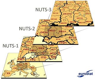
Nomenclature of Territorial Units for Statistics or NUTS is a geocode standard for referencing the administrative divisions of countries for statistical purposes. The standard, adopted in 2003, is developed and regulated by the European Union, and thus only covers the EU member states in detail. The Nomenclature of Territorial Units for Statistics is instrumental in the European Union's Structural Funds and Cohesion Fund delivery mechanisms and for locating the area where goods and services subject to European public procurement legislation are to be delivered.
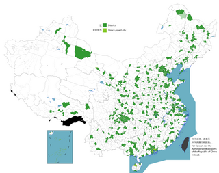
The term district, in the context of China, is used to refer to several unrelated political divisions in both ancient and modern China.

The census geographic units of Canada are the census subdivisions defined and used by Canada's federal government statistics bureau Statistics Canada to conduct the country's quinquennial census. These areas exist solely for the purposes of statistical analysis and presentation; they have no government of their own. They exist on four levels: the top-level (first-level) divisions are Canada's provinces and territories; these are divided into second-level census divisions, which in turn are divided into third-level census subdivisions and fourth-level dissemination areas.
The administrative divisions of North Korea are organized into three hierarchical levels. These divisions were created in 2002. Many of the units have equivalents in the system of South Korea. At the highest level are nine provinces and four special municipalities. The second-level divisions are cities, counties, and districts. These are further subdivided into third-level entities: towns, dongs (neighborhoods), ris (villages), and workers' districts.
An incorporated town is a town that is a municipal corporation.
A tehsil is a local unit of administrative division in India and Pakistan. It is a subdistrict of the area within a district including the designated populated place that serves as its administrative centre, with possible additional towns, and usually a number of villages. The terms in India have replaced earlier terms, such as pargana (pergunnah) and thana.
Districts are administrative subdivisions of the Republic of China (Taiwan)'s special municipalities of the second level and provincial cities of the third level formerly under its provinces. There are two types of district in the administrative scheme.

Government in Spain is divided into three spheres or levels: the State itself, the regions or autonomous communities and local entities. These levels are not hierarchical, meaning there is no supremacy or primacy of one over the other, but rather they are separately defined by their jurisdictional powers.
Townships, formally township-level divisions, are the basic level of political divisions in the People's Republic of China. They are similar to municipalities and communes in other countries and in turn may contain village committees and villages. In 1995 there were 29,648 townships and 17,570 towns in China which included the territories held by the Republic of China and claimed by the PRC.