Listed buildings in Bradmore, Nottinghamshire

Last updated

Bradmore is a civil parish in the Rushcliffe district of Nottinghamshire, England. The parish contains 19 listed buildings that are recorded in the National Heritage List for England. All the listed buildings are designated at Grade II, the lowest of the three grades, which is applied to "buildings of national importance and special interest". [1] The parish contains the village of Bradmore and the surrounding area, and all the listed buildings are in the village. The village buildings were largely destroyed by a fire in 1705, including the body of the church, but its tower and spire survived and are listed. Following the fire, Sir Thomas Parkyns of Bunny Hall, designed new buildings for the village, many of which are listed, and these include houses, farmhouses and farm buildings. The other listed buildings include a chapel and a telephone kiosk.

Contents

Map all coordinates using: OpenStreetMap  
Download coordinates as: KML

Buildings

Name and locationPhotographDateNotes
Tower and spire of former church
52°52′30″N1°08′02″W / 52.87487°N 1.13380°W / 52.87487; -1.13380 (Tower and spire of former church)
Bradmore Church - geograph.org.uk - 112265.jpg
13th centuryThe body of the church was destroyed in a fire in 1705. The tower is in stone on a plinth and has two stages, the upper stage dating from the 14h century. The lower stage has quoins and a window with a pointed arch. The upper stage contains bell openings with trefoil-arched lights. At the top is a parapet and the remains of a gargoyle, and it is surmounted by a broach spire. [2] [3]
Innisfree
52°52′28″N1°08′04″W / 52.87433°N 1.13436°W / 52.87433; -1.13436 (Innisfree)
17th centuryA timber framed cottage with brick infill, rendered at the rear, with a pantile roof. There is a single storey and an attic, and two bays. On the front is a porch and a 20th-century window, and at the rear are two dormers. Inside there is exposed timber framing. [4]
Blackcliffe Farmhouse
52°52′32″N1°07′58″W / 52.87565°N 1.13290°W / 52.87565; -1.13290 (Blackcliffe Farmhouse)
Blackcliffe Farmhouse, Bradmore.jpg
c. 1700The farmhouse is in red brick with stone dressings, floor bands, and a tile roof with brick coped gables and kneelers. There are two storeys and four bays, and to the left is a lean-to with a pantile roof. The doorway has a segmental head, and the windows are two-light casements with mullions. [5] [6]
Rufford Lodge, outbuildings and barn
52°52′31″N1°07′58″W / 52.87519°N 1.13276°W / 52.87519; -1.13276 (Rufford Lodge, outbuildings and barn)
Rufford Lodge, Bradmore.jpg
c. 1700The house is in rendered red brick, with floor bands, and a pantile roof with lead coped gables and kneelers. There are two storeys and attics, and three bays, and two rear wings. In the centre is a doorway, and the windows are two-light casements with mullions. Attached at the rear is a single-storey outbuilding converted for residential use, and beyond that is a two-storey barn with a large doorway, and a single-storey range. [5] [7]
15 Farmer Street
52°52′33″N1°07′59″W / 52.87581°N 1.13302°W / 52.87581; -1.13302 (15 Farmer Street)
15 Farmer Street, Bradmore.jpg
Early 18th centuryA house in red brick with a floor band, dentilled eaves, and a pantile roof with brick coped gables and kneelers. There are two storeys, three bays, a two-storey rear wing, and a single-storey single-bay wing on the left. In the centre is a doorway, the windows are tripartite casements, and the ground floor openings have segmental heads. [8]
Barn behind Blackcliffe Farmhouse
52°52′33″N1°07′56″W / 52.87591°N 1.13224°W
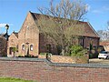
 / 52.87591; -1.13224 (Barn behind Blackcliffe Farmhouse)
Barn behind Blackcliffe Farmhouse, Bradmore.jpg
Early 18th centuryThe barn, later converted for residential use, is in red brick, and has a roof of tile and pantile with brick coped gables and kneelers. There is a single storey and attics, and two bays. The barn contains a large doorway, a smaller doorway with a segmental head, and blocked slit vents. [9]
Debdale and barn
52°52′29″N1°07′52″W / 52.87461°N 1.13124°W / 52.87461; -1.13124 (Debdale and barn)
Debdale, Bradmore.jpg
Early 18th centuryA farmhouse, later a house and cottage, and an attached barn, in red brick with two storeys. The house has a plinth, raised eaves bands, and a tile roof with brick coped gables and kneelers. There are two storeys and four bays, a doorway and casement windows, all with segmental heads. To the right is a lower cottage with a pantile roof and two bays, and further to the right is a single-storey single-bay outbuilding. To the left of the house is a barn with a pantile roof and five bays. In the ground floor are various blocked openings, including slit vents, and the upper floor contains fixed lights. [5] [10]
Barn east of Rancliffe Farmhouse
52°52′27″N1°07′54″W / 52.87419°N 1.13166°W / 52.87419; -1.13166 (Barn east of Rancliffe Farmhouse)
Early 18th centuryThe barn, later converted for residential use, is in red brick, and has a roof of pantile with brick coped gables and kneelers. There are two storeys and two bays. The barn contains a two-storey doorway, a casement windows, and eight slit vents. [11]
Stafford House and barn
52°52′32″N1°07′59″W / 52.87551°N 1.13304°W / 52.87551; -1.13304 (Stafford House and barn)
Stafford House and Barn, Bradmore.jpg
Early 18th centuryThe house and adjoining barn are in red brick. The house has floor bands, and a tile roof with a coped gable and a kneeler on the right. There are two storeys and five bays. Steps lead up to the central doorway, and the windows are a mix of sashes and casements. The barn attached to the left is of the same height, with a pantile roof and three storeys. The openings include a large segmental archway flanked by pilaster buttresses, and slit vents, and there are two blind segmental arches. [5] [12]
The Old Barn
52°52′26″N1°07′54″W / 52.87394°N 1.13176°W / 52.87394; -1.13176 (The Old Barn)
Early 18th centuryA threshing barn converted into a house in about 1980. It is in red brick on a splayed plinth, and has a pantile roof with brick coped gables and kneelers. There are two storeys and five bays. It contains a two-storey doorway flanked by pilaster buttresses, and to the right are two segmental arches. To the left is a fixed light in a former doorway with a segmental hood mould, a fixed light and blocked slit vents. [13]
Tofts Farmhouse
52°52′27″N1°07′51″W / 52.87416°N 1.13081°W / 52.87416; -1.13081 (Tofts Farmhouse)
Tofts Farmhouse, Bradmore.jpg
Early 18th centuryThe farmhouse is in red brick on a stepped plinth, with raised eaves bands and a tile roof. There are two storeys and a cellar, and three bays, and to the right is a lower wing with two storeys and an attic, and two bays. The windows in the main part are casements with raised brick arches, and in the wing they have flat heads. [14] [15]
Southwell House
52°52′28″N1°08′01″W / 52.87457°N 1.13371°W / 52.87457; -1.13371 (Southwell House)
Southwell House, Bradmore.jpg
1730A red brick house on a plinth, with stone dressings, a floor band, dentilled eaves, and a pantile roof with brick coped gables and kneelers. There are two storeys and six bays. On the front is a doorway and casement windows, the openings on the ground floor with segmental heads. In the left gable is a dated plaque. [5] [16]
Rancliffe Farmhouse
52°52′27″N1°07′55″W / 52.87424°N 1.13196°W / 52.87424; -1.13196 (Rancliffe Farmhouse)
Rancliffe Farmhouse, Bradmore.jpg
1736The farmhouse is in red brick with some black brick and stone, on a plinth, with a raised eaves band, and a tile roof with brick coped gables and corbelled out kneelers. There are three storeys and a cellar, and a double depth plan, with two gabled bays, and a recessed single-storey wing on the right. The cellar has four blocked segmental arches, and the windows are casements with segmental arches and brick hood moulds. In the gable apices are initials and the date in black brick headers. [2] [17]
28 Farmer Street
52°52′32″N1°08′00″W / 52.87560°N 1.13340°W
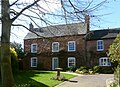
 / 52.87560; -1.13340 (28 Farmer Street)
28 Farmer Street, Bradmore.jpg
Mid 18th centuryTwo houses later combined into one, they are in red brick. The older house to the left dates mainly from the early 19th century, and has the remains of a floor band, dogtooth eaves and a slate roof. There are two storeys and three bays, a central doorway and sash windows, all the openings with segmental heads. The right house dates from the 20th-century and is lower, with a tile roof, two storeys and three bays, and various openings. [18]
130 Loughborough Road and outbuildings
52°52′26″N1°07′51″W / 52.87397°N 1.13072°W / 52.87397; -1.13072 (130 Loughborough Road and outbuildings)
Mid 18th centuryThe main range of the house dates from the early 19th century. It is in red brick with dentilled eaves and a pantile roof, two storeys and three bays. In the centre is a doorway, the windows are sashes, and all the openings have segmental heads. At the rear is an earlier wing with a single storey and attics and two bays with a tile roof. To the left of the house is a range of outbuildings. [19]
1 Main Street
52°52′29″N1°08′00″W / 52.87470°N 1.13342°W / 52.87470; -1.13342 (1 Main Street)
1 Main Street, Bradmore.jpg
Mid 18th centuryA house in whitewashed brick with a raised eaves band and a pantile roof. There are two storeys and four bays. On the front are a doorway, a single horizontally-sliding sash window in the upper floor, and the other windows are casements. All the openings in the ground floor have segmental arches. [20]
27 Farmer Street
52°52′30″N1°07′56″W / 52.87508°N 1.13236°W / 52.87508; -1.13236 (27 Farmer Street)
27 Farmer Street (2), Bradmore.jpg
Early 19th centuryA house in red brick with dogtooth eaves and a pantile roof. There are two storeys and four bays, the right bay added later. On the front is a recessed doorway and tripartite casement windows, the window in the right bay with a segmental arch. [21]
Wesleyan Methodist Chapel
52°52′31″N1°07′57″W / 52.87522°N 1.13243°W / 52.87522; -1.13243 (Wesleyan Methodist Chapel)
Bradmore Methodist Church - geograph.org.uk - 1771498.jpg
1830The chapel is built with red brick stretchers and pink headers, and has a hipped slate roof. There is a single storey and three bays, and it contains three round-arched casement windows. [2] [22]
Telephone kiosk
52°52′29″N1°07′59″W / 52.87486°N 1.13312°W
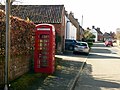
 / 52.87486; -1.13312 (Telephone kiosk)
Telephone kiosk, Bradmore.jpg
1935The K6 type telephone kiosk in Main Street near Rufford Lodge was designed by Giles Gilbert Scott. Constructed in cast iron with a square plan and a dome, it has three unperforated crowns in the top panels. [23]

Related Research Articles

Ribchester is a civil parish in Ribble Valley, Lancashire, England. It contains 23 listed buildings that are recorded in the National Heritage List for England. Of these, one is listed at Grade I, the highest of the three grades, one is at Grade II*, the middle grade, and the others are at Grade II, the lowest grade. The parish contains the village of Ribchester, and surrounding countryside. Most of the listed buildings are houses and associated structures, or farmhouses and farm buildings, some of which are in the village, and others are in the rural area. The other listed buildings are two churches, a presbytery, a sundial, a public house with a mounting block outside, a bridge, and almshouses with a wellhead in the grounds.

Barlow is a civil parish in the North East Derbyshire district of Derbyshire, England. The parish contains 18 listed buildings that are recorded in the National Heritage List for England. Of these, three are listed at Grade II*, the middle of the three grades, and the others are at Grade II, the lowest grade. The parish contains the village of Barlow and the surrounding countryside, mainly to the west of the village. It is almost entirely rural, and the listed buildings are mainly houses and associated structures, farmhouses and farm buildings. The other listed buildings are a church, its former rectory, a bridge, a former school, a pinfold, and a village pump.

Beeley is a civil parish in the Derbyshire Dales district of Derbyshire, England. The parish contains 20 listed buildings that are recorded in the National Heritage List for England. Of these, three are listed at Grade II*, the middle of the three grades, and the others are at Grade II, the lowest grade. The parish contains the village of Beeley and the surrounding countryside and moorland, mainly to the east of the village. Most of the listed buildings are houses, cottages, and associated structures. The other listed buildings include a church, a public house, a guide post and guide stone, a farmhouse, a converted barn, a former school, and a former vicarage.

Brampton is a civil parish in the North East Derbyshire district of Derbyshire, England. The parish contains 37 listed buildings that are recorded in the National Heritage List for England. Of these, one is listed at Grade I, the highest of the three grades, three are at Grade II*, the middle grade, and the others are at Grade II, the lowest grade. The parish contains the villages of Cutthorpe, Old Brampton, and Wadshelf, and the surrounding countryside. Most of the listed buildings are houses and associated structures, farmhouses and farm buildings. The other listed buildings include a church, a chapel, and two guide posts.

Crich is a civil parish in the Amber Valley district of Derbyshire, England. The parish contains 52 listed buildings that are recorded in the National Heritage List for England. Of these, one is listed at Grade I, the highest of the three grades, one is at Grade II*, the middle grade, and the others are at Grade II, the lowest grade. The parish contains the villages of Crich, Fritchley, Whatstandwell, and Wheatcroft, and the surrounding countryside. Most of the listed buildings are houses, cottages and associated structures, farmhouses and farm buildings. In the parish is the National Tramway Museum, and a number of structures that have been moved from other sites to the museum are listed. The other listed buildings include churches and chapels, a bridge over the Cromford Canal and a road bridge over the River Derwent, public houses, buildings associated with tramways, a milepost, a village cross, a memorial tower, and a village telephone kiosk.

Eckington is a civil parish in the North East Derbyshire district of Derbyshire, England. The parish contains 81 listed buildings that are recorded in the National Heritage List for England. Of these, two are listed at Grade I, the highest of the three grades, two are at Grade II*, the middle grade, and the others are at Grade II, the lowest grade. The parish contains the town of Eckington, the villages of Renishaw, Ridgeway, and Spinkhill, the hamlet of Birley Hay, and the surrounding countryside. The major building in the parish is the country house, Renishaw Hall, which is listed, together with associated structures and items in its grounds. Most of the other listed buildings are houses, cottages and associated structures, farmhouses and farm buildings. The rest of the listed buildings include churches, chapels and associated items, a former Sunday school, a former toll house, a public house, and two bridges.

Kirk Ireton is a civil parish in the Derbyshire Dales district of Derbyshire, England. The parish contains 27 listed buildings that are recorded in the National Heritage List for England. Of these, one is listed at Grade I, the highest of the three grades, one is at Grade II*, the middle grade, and the others are at Grade II, the lowest grade. The parish contains the village of Kirk Ireton and the surrounding countryside. Most of the listed buildings are houses, cottages and associated structures, farmhouses and farm buildings, and the others are churches and associated structures, and a public house.

Unstone is a civil parish in the North East Derbyshire district of Derbyshire, England. The parish contains 15 listed buildings that are recorded in the National Heritage List for England. Of these, two are listed at Grade II*, the middle of the three grades, and the others are at Grade II, the lowest grade. The parish contains the villages of Unstone, Apperknowle and West Handley and smaller settlements, and is otherwise rural. Apart from a railway viaduct, all the listed buildings are houses, cottages and associated structures, farmhouses, and farm buildings.

Walton-on-Trent is a civil parish in the South Derbyshire district of Derbyshire, England. The parish contains nine listed buildings that are recorded in the National Heritage List for England. Of these, two are listed at Grade II*, the middle of the three grades, and the others are at Grade II, the lowest grade. The parish contains the village of Walton-on-Trent and the surrounding area. The listed buildings consist of houses, cottages and associated structures, farmhouses and farm buildings, and a church and its lychgate.

Wormhill is a civil parish in the High Peak district of Derbyshire, England. The parish contains 26 listed buildings that are recorded in the National Heritage List for England. Of these, three are listed at Grade II*, the middle of the three grades, and the others are at Grade II, the lowest grade. The parish contains the village of Wormhill and the surrounding area. Most of the listed buildings are houses, cottages and associated structures, farmhouses and farm buildings. The other listed buildings include a church and associated structures, a village cross moved into the churchyard, a railway viaduct, and a memorial fountain.

Yeaveley is a civil parish in the Derbyshire Dales district of Derbyshire, England. The parish contains nine listed buildings that are recorded in the National Heritage List for England. Of these, one is listed at Grade I, the highest of the three grades, one is at Grade II*, the middle grade, and the others are at Grade II, the lowest grade. The parish contains the village of Yeaveley and the surrounding countryside. The oldest listed building in the parish consists of the remains of a preceptory of the Knights Hospitaller. The other listed buildings are houses and associated structures, farmhouses and farm buildings, and a church.

Yeldersley is a civil parish in the Derbyshire Dales district of Derbyshire, England. The parish contains 14 listed buildings that are recorded in the National Heritage List for England. All the listed buildings are designated at Grade II, the lowest of the three grades, which is applied to "buildings of national importance and special interest". The parish is almost entirely rural, with no substantial settlements, and the listed buildings consist of houses, cottages and associated structures, farmhouses and farm buildings, and a milepost.

Youlgreave is a civil parish in the Derbyshire Dales district of Derbyshire, England. The parish contains 57 listed buildings that are recorded in the National Heritage List for England. Of these, one is listed at Grade I, the highest of the three grades, one is at Grade II*, the middle grade, and the others are at Grade II, the lowest grade. The parish contains the village of Youlgreave, the hamlet of Alport and the surrounding countryside. Most of the listed buildings are houses, cottages and associated structures, farmhouses and farm buildings. The other listed buildings include a church and associated structures, a public house, bridges, a milestone, a conduit head, a school, a youth hostel and a telephone kiosk.

Babworth is a civil parish in the Bassetlaw District of Nottinghamshire, England. The parish contains 21 listed buildings that are recorded in the National Heritage List for England. Of these, one is listed at Grade I, the highest of the three grades, one is at Grade II*, the middle grade, and the others are at Grade II, the lowest grade. The parish contains the villages of Babworth and Ranby, and is otherwise rural. The listed buildings include three country houses, their lodges and associated structures. The other listed buildings are a church, houses and cottages, a public house, a canal bridge, a commemorative stone, and a war memorial.

Ordsall is a village in the Bassetlaw District of Nottinghamshire, England, near the market town of Retford. The village contains seven listed buildings that are recorded in the National Heritage List for England. Of these, one is at Grade II*, the middle of the three grades, and the others are at Grade II, the lowest grade. The listed buildings consist of a church, its former rectory, a war memorial in the churchyard, and houses and cottages with associated structures.

Bathley is a civil parish in the Newark and Sherwood district of Nottinghamshire, England. The parish contains five listed buildings that are recorded in the National Heritage List for England. All the listed buildings are designated at Grade II, the lowest of the three grades, which is applied to "buildings of national importance and special interest". The parish contains the village of Bathley and the surrounding countryside, and the listed buildings consist of houses, farmhouses and a farm building.

Beckingham is a civil parish in the Bassetlaw District of Nottinghamshire, England. The parish contains 15 listed buildings that are recorded in the National Heritage List for England. Of these, one is listed at Grade II*, the middle of the three grades, and the others are at Grade II, the lowest grade. The parish contains the village of Beckingham and the surrounding countryside. Most of the listed buildings are houses, farmhouses and associated structures, and the others include a church and its churchyard wall, three buildings associated with Beckingham railway station, and a war memorial.

Blidworth is a civil parish in the Newark and Sherwood district of Nottinghamshire, England. The parish contains nine listed buildings that are recorded in the National Heritage List for England. Of these, one is at Grade II*, the middle of the three grades, and the others are at Grade II, the lowest grade. The parish contains the village of Blidworth and the surrounding area. The listed buildings consist of a church, headstones in the churchyard and its gateway, a house and associated features, a farmhouse, a former windmill, and a well head.

Blyth is a civil parish in the Bassetlaw District of Nottinghamshire, England. The parish contains 53 listed buildings that are recorded in the National Heritage List for England. Of these, three are listed at Grade I, the highest of the three grades, and the others are at Grade II, the lowest grade. The parish contains the village of Blyth and the surrounding countryside. To the north of the village is the country house Serlby Hall, which is listed, together with associated structures around the house and in Serlby Park. The other listed buildings are in or around the village, and most of them are houses, cottages and associated structures, farmhouses and farm buildings. The other listed buildings include a church and items in the churchyard, a hotel and public houses, bridges, a milestone, a war memorial and a telephone kiosk.

Hodsock is a civil parish in the Bassetlaw District of Nottinghamshire, England. The parish contains 17 listed buildings that are recorded in the National Heritage List for England. Of these, one is listed at Grade I, the highest of the three grades, and the others are at Grade II, the lowest grade. The parish is almost entirely rural, containing no substantial settlements. The most important building in the parish is a 16th-century gatehouse, which is listed, together with its associated country house. The other listed buildings consist of houses and associated structures, farmhouses and farm buildings, a former watermill, a bridge and a war memorial.

References

Citations

Sources