Widnes is an industrial town in the Borough of Halton, Cheshire, England, on the north bank of the River Mersey where it narrows at Runcorn Gap. The town contains 24 buildings that are recorded in the National Heritage List for England as designated listed buildings. Of these, 5 are classified at Grade II*, and the rest are at Grade II; Widnes has no Grade I listed buildings. In the United Kingdom, the term "listed building" refers to a building or other structure officially designated as being of special architectural, historical, or cultural significance. Listed buildings are categorised in three grades: Grade I consists of buildings of outstanding architectural or historical interest; Grade II* includes particularly significant buildings of more than local interest; Grade II consists of buildings of special architectural or historical interest. Buildings in England are listed by the Secretary of State for Culture, Media and Sport on recommendations provided by English Heritage, which also determines the grading.
The Grade I listed buildings in Cheshire, excluding those in the city of Chester, total around 80. Almost half of these are churches that are contained in a separate list.
Grappenhall and Thelwall is a civil parish in the Borough of Warrington and the ceremonial county of Cheshire, England, and includes the villages of Grappenhall and Thelwall. The Bridgewater Canal and the A56 road pass through Grappenhall and to the south of Thelwall in an east–west direction, and the A50 road runs in a north–south direction between them. Within the parish are 30 buildings that are recorded in the National Heritage List for England as designated listed buildings. Of these, one is listed at Grade I, the highest of the three grades, and the other 28 at Grade II, the lowest grade. The Grade I listed building is a church dating back to the 12th century. The Grade II listed buildings comprise a variety of structures, including another church, houses, aqueducts, bridges, a public house, farm buildings, stocks, a sundial, a milepost, a mounting block, a war memorial, and a telephone kiosk.
Croft is a village and civil parish in the Borough of Warrington in Cheshire, England, north of the town of Warrington. It contains 13 buildings that are recorded in the National Heritage List for England as designated listed buildings. All of these are listed at Grade II, the lowest of the three gradings given to listed buildings, applied to "buildings of national importance and special interest". The parish is mainly rural, and other than a milestone its listed buildings are related to churches, houses or farms.
Winwick is a village and civil parish in the Borough of Warrington in Cheshire, England, north of the town of Warrington. It contains 16 buildings that are recorded in the National Heritage List for England as designated listed buildings. The parish is partly residential and partly rural. The listed buildings include two churches, a holy well, two milestones, and a mounting block. The other structures are houses, farms, or buildings related to them.
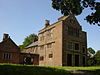
Walton is a civil parish in the Borough of Warrington in Cheshire, England. It contains 22 buildings that are recorded in the National Heritage List for England as designated listed buildings. The parish is centred on Walton Hall, the former home of the Greenall family. The hall itself is listed, as are surrounding structures related to the hall. Also listed are the nearby parish church and its lychgate, and cottages and a former school in the Walton Hall Estate. The Bridgewater Canal runs through the parish; related to this are six listed structures, namely five bridges and an aqueduct. The other listed buildings are a former farmhouse dating from about 1800, a late 18th-century house, and an early 19th-century farmhouse. All the buildings are listed at Grade II, other than the parish church which is listed at Grade II*.
Culcheth and Glazebury is a civil parish in the Borough of Warrington, ceremonial county of Cheshire and historic county of Lancashire, England, northeast of the town of Warrington. It contains eleven buildings that are recorded in the National Heritage List for England as designated listed buildings. Other than the villages of Culcheth and Glazebury, the parish is rural. The A574 road runs through it, and two milestones adjacent to the road are listed. In addition a parish boundary stone on the B5207 road is listed. The church in Glazebury is also listed; all the other listed buildings are related to houses or farms.
Great Sankey is a civil parish in the Borough of Warrington in Cheshire, England, and is a suburb to the west of the town of Warrington. It contains seven buildings that are recorded in the National Heritage List for England as designated listed buildings, all of which are at Grade II. This is the lowest of the three gradings given to listed buildings, applied to "buildings of national importance and special interest". The parish is almost completely residential. The listed buildings consist of a church and a sundial in its churchyard, a railway station, a mounting block, a former pillbox, and two milestones.
Warrington is a town, borough and unitary authority area of Cheshire, England. The unitary authority contains 18 civil parishes, which are distributed around its periphery. Its central area, including the town, is unparished. This list contains the 141 structures in the unparished area that are designated by English Heritage as listed buildings and included in the National Heritage List for England. Of these, three buildings are listed at Grade I, and ten at Grade II*. The remaining buildings are listed at Grade II. The listed buildings in the civil parishes are included in separate lists.
There are over 9,000 Grade I listed buildings and 20,000 Grade II* listed buildings in England. This page is a list of these buildings in the unitary authority of Warrington in Cheshire, including the town of Warrington and 18 other civil parishes.
There are over 20,000 Grade II* listed buildings in England. This page is a list of these buildings in the unitary authority of Cheshire West and Chester.
St Helens is a town in the Metropolitan Borough of St Helens, Merseyside, England. The unparished area contains 67 buildings that are recorded in the National Heritage List for England as designated listed buildings. Of these, one is listed at Grade I, the highest grade, five are listed at Grade II*, the middle of the three grades, and the others are at Grade II, the lowest grade. The main town in the district is St Helens, the others being Newton-le-Willows and Earlestown. Until the Industrial Revolution, the area was largely rural. Coal mining began in the 16th century, but modern industrial development began with the construction of the Sankey Canal in the late 18th century, linking St Helens with the River Mersey. The early 19th century saw new industries, including copper smelting, production of alkali, and the manufacture of glass. Of these, the major industry was glass making, the main business being that of Pilkingtons. The first major railway line in the world, the Liverpool and Manchester Railway was built through the district, opening in 1830.
Rainford is a civil parish in St Helens, Merseyside, England. It contains 27 buildings that are recorded in the National Heritage List for England as designated listed buildings. Of these, one is listed at Grade II*, the middle of the three grades, and the others are at Grade II, the lowest grade. Apart from the village of Rainford, the parish is rural. The listed buildings are mainly houses, farmhouses, farm buildings and associated structures. Other listed buildings include a public house, a church, village stocks, a former mill, and a pair of statues.
Eccleston is a civil parish in the Borough of Chorley, Lancashire, England. The parish contains 16 buildings that are recorded in the National Heritage List for England as designated listed buildings. Of these, three are listed at Grade II*, the middle grade, and the others are at Grade II, the lowest grade. The parish contains the village of Eccleston, which is surrounded by agricultural land. Most of the listed buildings are houses, farmhouses, and farm buildings. The other listed buildings are the parish church and structures in its churchyard, a public house, a former school, a bridge, and a former savings bank.
Bickerstaffe is a civil parish in the West Lancashire district of Lancashire, England. It contains twelve listed buildings that are recorded in the National Heritage List for England. All of the listed buildings are designated at Grade II, the lowest of the three grades, which is applied to "buildings of national importance and special interest". The parish contains the village of Bickerstaffe and the hamlet of Barrow Nook, and is otherwise rural. The listed buildings include houses, farmhouses and farm buildings, a church, structures associated with the Friends' Burial Ground, a converted windmill, a boundary stone, stocks, and a war memorial.
Dalton is a civil parish in the West Lancashire district of Lancashire, England. It contains ten buildings that are recorded in the National Heritage List for England as designated listed buildings. Of these, one is at Grade II*, the middle grade, and the others are at Grade II, the lowest grade. The parish contains the village of Dalton, and is otherwise rural. Most of the listed buildings are farmhouses, or houses and associated structures, the others being a church, and a landmark in the form of a beacon.
Haigh is a civil parish in the Metropolitan Borough of Wigan, Greater Manchester, England. It contains 30 listed buildings that are recorded in the National Heritage List for England. Of these, one is listed at Grade II*, the middle grade, and the others are at Grade II, the lowest grade. The parish contains the village of Haigh, the estate of Haigh Hall, and the surrounding countryside. The most important building in the parish is Haigh Hall; this and a number of buildings in the estate are listed. The Leeds and Liverpool Canal runs through the parish, and three bridges associated with it are listed. The other listed buildings include farmhouses, farm buildings, a set of stocks, houses, workers' cottages, a church and associated structures, a school, and a bridge over a disused railway.
Standish is a town in the Metropolitan Borough of Wigan, Greater Manchester, England. It contains 22 listed buildings that are recorded in the National Heritage List for England. Of these, one is listed at Grade I, the highest of the three grades, two are at Grade II*, the middle grade, and the others are at Grade II, the lowest grade. The town and the surrounding countryside contain a variety of listed buildings, including three medieval cross bases, a village cross and stocks, houses, a church and associated structures, farmhouses, three mileposts, a drinking fountain, and two war memorials.