Listed buildings in Monyash

Last updated

Monyash is a civil parish in the Derbyshire Dales district of Derbyshire, England. The parish contains 17 listed buildings that are recorded in the National Heritage List for England. Of these, one is listed at Grade II*, the middle of the three grades, and the others are at Grade II, the lowest grade. The parish contains the village of Monyash and the surrounding countryside. Most of the listed buildings are houses, cottages and associated structures, farmhouses and farm buildings. The other listed buildings include a church, a former chapel, a village cross, a public house, and a telephone kiosk.

Contents

Key

Map all coordinates using: OpenStreetMap
GradeCriteria [1]
II*Particularly important buildings of more than special interest
IIBuildings of national importance and special interest

Buildings

Name and locationPhotographDateNotesGrade
St Leonard's Church
53°11′43″N1°46′29″W / 53.19515°N 1.77477°W / 53.19515; -1.77477 (St Leonard's Church)
St Leonard's, Monyash - geograph.org.uk - 1338049.jpg
Early 13th centuryThe church has been altered and extended through the centuries, and was restored and extended in 1885–88 by William Butterfield. It is built in limestone with gritstone dressings, and has roofs mainly in stone slate, with some lead. The church consists of a nave with north and south aisles, a south porch, north and south transepts, a chancel and a west steeple. The steeple has a tower with three stages, buttresses, moulded string courses, a north clock face, a north gargoyle, an embattled parapet, and a recessed octagonal spire with two tiers of lucarnes. [2] [3] II*
Village Cross
53°11′45″N1°46′37″W / 53.19586°N 1.77701°W / 53.19586; -1.77701 (Village Cross)
Monyash, market cross.jpg
MedievalThe oldest part of the cross is the base, with the shaft dating from later. The base consists of large limestone blocks with smaller square plinth. On this is a gritstone octagonal base, and a gritstone tapering shaft about 7 feet (2.1 m) high, with a small head. [4] [5] II
The Bull's Head Public House
53°11′46″N1°46′36″W / 53.19600°N 1.77662°W / 53.19600; -1.77662 (The Bull's Head Public House)
The Bull's Head - geograph.org.uk - 1338042.jpg
1619The public house, which was extended in the 18th century, is in limestone with quoins and tile roofs. The original part has two storeys and two bays, gritstone dressings, and a coped gable on the west. To the left is a blocked doorway with a quoined surround, a four-centred arched head, incised spandrels, and a dated lintel, to its right is a 19th-century doorway with a large lintel and a hood mould, and further to the right is a 20th-century doorway with a flat hood on brackets. The windows in this part are mullioned. The extension to the right has three storeys and two bays, and limestone dressings. The windows have chamfered surrounds, and those in the lower two floors have hoods. [4] [6] II
Former Quaker Chapel
53°11′50″N1°46′37″W / 53.19722°N 1.77701°W
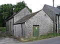
 / 53.19722; -1.77701 (Former Quaker Chapel)
Former Quaker Chapel, Monyash.jpg
c. 1711The chapel was converted from a cottage, enlarged in the 19th century, and later used for other purposes. It is in limestone with dressings in limestone and gritstone and has a roof of stone slate and tile. There are two storeys and single-storey additions. The doorway has a large lintel, there is one tall sash window, and the other windows are mullioned. At the rear, the south front is open and carried on cast iron columns. [4] [7] II
Manor House Farmhouse
53°11′36″N1°46′29″W / 53.19332°N 1.77459°W / 53.19332; -1.77459 (Manor House Farmhouse)
House by a lane corner in Monyash - geograph.org.uk - 2870402.jpg
1714The farmhouse, which was refronted in the 19th century, is in limestone with gritstone dressings, chamfered quoins, a moulded eaves cornice, and a tile roof with a coped north gable and a moulded kneeler. There are two storeys, a double pile plan and three bays. The central doorway has a moulded surround, an initialled and dated lintel, and a moulded hood on brackets. The windows are sashes with long-and-short surrounds and keystones. On the sides of the house are three-light mullioned windows. [8] II
Shuttle Hill Cottage
53°11′50″N1°46′37″W / 53.19731°N 1.77693°W / 53.19731; -1.77693 (Shuttle Hill Cottage)
1747A pair of cottages with massive quoins and a slate roof. There are two storeys, and each cottage has two bays. The doorways in the centre have large lintels, most of the windows are mullioned, and some are inserted casements. Between the doorways is an initialled datestone. [9] II
One Ash Grange Farmhouse, cottage and barn
53°11′02″N1°44′55″W / 53.18388°N 1.74855°W / 53.18388; -1.74855 (One Ash Grange Farmhouse, cottage and barn)
18th centuryA farmhouse, cottage and barn under a continuous roof, they are in limestone with gritstone dressings, quoins, and a stone slate roof with coped gables and moulded kneelers on the west. There are two storeys with attics over the middle part, the house has six bays and the barn has two. Most of the windows are mullioned, and there are some sashes and casements, and a doorway with a segmental arched head. In the barn is a large segmental archway with a keystone. [10] II
Pigsties, One Ash Grange
53°11′03″N1°44′56″W / 53.18411°N 1.74881°W / 53.18411; -1.74881 (Pigsties, One Ash Grange)
Pigsties at One Ash Grange 01.jpg
18th centuryA row of pigsties in limestone with gritstone dressings and a stone slate roof. There is a single storey with four pens in front, enclosed by walls with slab copings. On the front are four gateways with feeding troughs between, consisting of twin niches with sloping stone slabs. Each sty has a low opening. [11] II
Sheldon House
53°11′52″N1°46′37″W / 53.19782°N 1.77687°W / 53.19782; -1.77687 (Sheldon House)
Sheldon House, Monyash 02.jpg
1774A limestone house with quoins, string courses, and a stone slate roof. There are three storeys and two bays, the left bay projecting, with a porch in the angle. The windows are mullioned, and on the left bay is a square plaque with moulded edges inscribed with a circle and a date. [12] II
Ivy Cottage
53°11′45″N1°46′29″W / 53.19572°N 1.77470°W
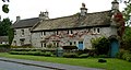
 / 53.19572; -1.77470 (Ivy Cottage)
Houses on Church Street, Monyash - geograph.org.uk - 2613488.jpg
Late 18th centuryA farmhouse, later a private house, in limestone with gritstone dressings, and a stone slate roof with moulded gable copings and kneelers. There are two storeys and four bays. The doorway has a large lintel and to its left is a single-light casement window. The other windows are mullioned with two casements, those in the ground floor with hood moulds. [13] II
Mere Farmhouse and outbuilding
53°11′41″N1°46′39″W / 53.19476°N 1.77742°W / 53.19476; -1.77742 (Mere Farmhouse and outbuilding)
Mere Farmhouse, Monyash.jpg
Late 18th centuryThe farmhouse is in limestone with painted dressings and a tile roof. There are two storeys and two bays. The central doorway has a four-centred arch and a canopy, and the windows are mullioned with two lights. The outbuilding is attached to the south. [14] II
Townend Farmhouse
53°11′56″N1°46′37″W / 53.19884°N 1.77694°W / 53.19884; -1.77694 (Townend Farmhouse)
Late 18th centuryThe farmhouse is in limestone with gritstone dressings, chamfered quoins, and a tile roof with coped gables and moulded kneelers. There are two storeys and four bays. The doorway has a chamfered quoined surround, and a lintel with incised voussoirs and a keystone. Over the doorway is a single-light window, and the other windows are mullioned with two lights. [15] II
Former Post Office, house and dairy
53°11′45″N1°46′39″W / 53.19583°N 1.77749°W / 53.19583; -1.77749 (Former Post Office, House and dairy)
Row of terraced cottages in Monyash - geograph.org.uk - 1846683.jpg
Early 19th centuryA terrace of three cottages in limestone with limestone dressings and a tile roof. There are two storeys and six bays. The doorways have flush surrounds, there is one shop window, and the other windows are sashes. [16] II
The Whim Farmhouse
53°11′39″N1°47′52″W / 53.19415°N 1.79783°W / 53.19415; -1.79783 (The Whim Farmhouse)
The Whim Farmhouse, Monyash.jpg
Early 19th centuryThe farmhouse is in painted limestone with gritstone dressings, quoins, and a stone slate roof. There are two storeys and two bays. The central doorway has plain jambs and a lintel, and a moulded hood, and the windows are sashes. [17] II
Old Hall Cottages
53°11′39″N1°46′38″W / 53.19419°N 1.77713°W / 53.19419; -1.77713 (Old Hall Cottages)
Monyash - Old Hall Cottages - 20180122100829.jpg
c. 1840A terrace of four cottages, the left cottage added later. They are in limestone with gritstone dressings, quoins, and a tile roof hipped on the right. There are two storeys and six bays. The windows are sashes, some of the doorways have quoined surrounds, and some of the ground floor openings have Tudor-style hood moulds. [18] II
Chandlers
53°11′42″N1°46′39″W / 53.19508°N 1.77753°W / 53.19508; -1.77753 (Chandlers)
Chandlers, Monyash.jpg
Mid-19th centuryA farmhouse in limestone with gritstone dressings, quoins, a plain eaves band, and a stone slate roof with coped gables and moulded kneelers. There are two storeys and three bays. The central doorway has a quoined surround, a fanlight, and a bracketed hood. The windows are sashes in quoined surrounds. [19] II
Telephone kiosk
53°11′46″N1°46′38″W / 53.19601°N 1.77732°W / 53.19601; -1.77732 (Telephone kiosk)
Chapel Lane - geograph.org.uk - 1338077.jpg
1935The K6 type telephone kiosk in an enclosure by the village green was designed by Giles Gilbert Scott. Constructed in cast iron with a square plan and a dome, it has three unperforated crowns in the top panels. [20] II

Related Research Articles

Biggin by Hulland is a civil parish in the Derbyshire Dales district of Derbyshire, England. The parish contains eight listed buildings that are recorded in the National Heritage List for England. All the listed buildings are designated at Grade II, the lowest of the three grades, which is applied to "buildings of national importance and special interest". Apart from the village of Biggin by Hulland, the parish is entirely rural, and all the listed buildings are houses or cottages.

Bonsall is a civil parish in the Derbyshire Dales district of Derbyshire, England. The parish contains 13 listed buildings that are recorded in the National Heritage List for England. Of these, two are listed at Grade II*, the middle of the three grades, and the others are at Grade II, the lowest grade. The parish contains the village of Bonsall and the surrounding area. The listed buildings consist of houses, cottages and associated structures, a farmhouse and an outbuilding, a market cross, two churches, a public house, a sawmill converted for residential use, and a telephone kiosk.

Bretby is a civil parish in the South Derbyshire district of Derbyshire, England. The parish contains 13 listed buildings that are recorded in the National Heritage List for England. Of these, two are listed at Grade II*, the middle of the three grades, and the others are at Grade II, the lowest grade. The parish contains the village of Bretby and the surrounding countryside. The listed buildings include houses, cottages and associated structures, a farmhouse and farm buildings, a church, a former school, a former watermill, a bottle kiln and factory, a war memorial and village pump, and a telephone kiosk.

Castleton is a civil parish in the High Peak district of Derbyshire, England. The parish contains 25 listed buildings that are recorded in the National Heritage List for England. Of these, one is listed at Grade I, the highest of the three grades, one is at Grade II*, the middle grade, and the others are at Grade II, the lowest grade. The parish contains the village of Castleton and the surrounding countryside and moorland. The most important building in the parish is the ruined Peveril Castle, which is listed at Grade I. The other listed buildings include houses, cottages and associated structures, farmhouses and farm buildings, a church and a sundial in the churchyard, a hotel and a public house, a former watermill, three mileposts, a school, a war memorial, and a telephone kiosk.

Crich is a civil parish in the Amber Valley district of Derbyshire, England. The parish contains 52 listed buildings that are recorded in the National Heritage List for England. Of these, one is listed at Grade I, the highest of the three grades, one is at Grade II*, the middle grade, and the others are at Grade II, the lowest grade. The parish contains the villages of Crich, Fritchley, Whatstandwell, and Wheatcroft, and the surrounding countryside. Most of the listed buildings are houses, cottages and associated structures, farmhouses and farm buildings. In the parish is the National Tramway Museum, and a number of structures that have been moved from other sites to the museum are listed. The other listed buildings include churches and chapels, a bridge over the Cromford Canal and a road bridge over the River Derwent, public houses, buildings associated with tramways, a milepost, a village cross, a memorial tower, and a village telephone kiosk.

Elvaston is a civil parish in the South Derbyshire district of Derbyshire, England. The parish contains 28 listed buildings that are recorded in the National Heritage List for England. Of these, one is listed at Grade I, the highest of the three grades, one is at Grade II*, the middle grade, and the others are at Grade II, the lowest grade. The parish contains the village of Elvaston and the surrounding area, including the country house Elvaston Castle, which is listed, together with associated structures and buildings in its grounds. The other listed buildings are houses and cottages, a church and associated structures, two mileposts, a former school and schoolmaster's house, and a war memorial.

Great Longstone is a civil parish in the Derbyshire Dales district of Derbyshire, England. The parish contains 31 listed buildings that are recorded in the National Heritage List for England. Of these, one is listed at Grade I, the highest of the three grades, one is at Grade II*, the middle grade, and the others are at Grade II, the lowest grade. The parish contains the village of Great Longstone and the surrounding area. Most of the listed buildings are houses, cottages and farmhouses and associated structures. Part of the gardens of Thornbridge Hall are in the parish, and these contain a number of listed buildings. The other listed buildings include a church, a cross in the churchyard, the village cross, two public houses, a former guidepost used as a gatepost, a former railway station, a war memorial, and a telephone kiosk.

Hartington Nether Quarter is a civil parish in the Derbyshire Dales district of Derbyshire, England. The parish contains 24 listed buildings that are recorded in the National Heritage List for England. Of these, one is listed at Grade II*, the middle of the three grades, and the others are at Grade II, the lowest grade. The parish is mainly rural, to the east of the village of Hartington, and it contains the settlements of Biggin, Friden, Heathcote, Newhaven and Pikehall. Most of the listed buildings are houses, cottages, farmhouses, and associated structures, and the others are a hotel, a church, and two mileposts.

Hognaston is a civil parish in the Derbyshire Dales district of Derbyshire, England. The parish contains nine listed buildings that are recorded in the National Heritage List for England. Of these, one listed at Grade II*, the middle of the three grades, and the others are at Grade II, the lowest grade. The parish contains the village of Hognaston and the surrounding area. The listed buildings consist of houses, cottages, farmhouses, a church, and a telephone kiosk.

Horsley and Horsley Woodhouse are civil parishes in the Amber Valley district of Derbyshire, England. The parishes contain eight listed buildings that are recorded in the National Heritage List for England. Of these, one is listed at Grade I, the highest of the three grades, and the others are at Grade II, the lowest grade. The parishes contain the villages of Horsley and Horsley Woodhouse and the surrounding area. The listed buildings consist of a church, a cottage, a farmhouse and farm buildings, the remains of buildings in the garden of a demolished house, a milepost, a water fountain, and a former post box.

Ingleby is a civil parish in the South Derbyshire district of Derbyshire, England. The parish contains five listed buildings that are recorded in the National Heritage List for England. Of these, one is listed at Grade II*, the middle of the three grades, and the others are at Grade II, the lowest grade. The parish contains the village of Ingleby and the surrounding area, and the listed buildings consist of houses, cottages, farmhouses, and associated structures.

Linton is a civil parish in the South Derbyshire district of Derbyshire, England. The parish contains three listed buildings that are recorded in the National Heritage List for England. All the listed buildings are designated at Grade II, the lowest of the three grades, which is applied to "buildings of national importance and special interest". The parish contains the village of Linton and the surrounding countryside, and the listed buildings consist of a house, a farmhouse, and a cottage orné.

Middleton and Smerrill is a civil parish in the Derbyshire Dales district of Derbyshire, England. The parish contains 31 listed buildings that are recorded in the National Heritage List for England. All the listed buildings are designated at Grade II, the lowest of the three grades, which is applied to "buildings of national importance and special interest". The parish contains the village of Middleton-by-Youlgreave and the surrounding countryside. Most of the listed buildings are houses, cottages and associated structures, farmhouses and farm buildings. The other listed buildings include a church, a former chapel with a tomb in its grounds, a smithy, a former public house, a drinking fountain and a telephone kiosk.

Over Haddon is a civil parish in the Derbyshire Dales district of Derbyshire, England. The parish contains eight listed buildings that are recorded in the National Heritage List for England. All the listed buildings are designated at Grade II, the lowest of the three grades, which is applied to "buildings of national importance and special interest". The parish contains the village of Over Haddon and the surrounding countryside. The listed buildings consist of three farmhouses and associated structures, a former cotton mill and sluice gate, a footbridge over the River Lathkill, a house, a church, and a telephone kiosk.

Repton is a civil parish in the South Derbyshire district of Derbyshire, England. The parish contains 53 listed buildings that are recorded in the National Heritage List for England. Of these, six are listed at Grade I, the highest of the three grades, one is at Grade II*, the middle grade, and the others are at Grade II, the lowest grade. The parish contains the village of Repton, the smaller village of Milton, and the surrounding area. The major complex of buildings is associated with Repton School, built on the site of an earlier priory. Many of these are listed, four of them at Grade I. The other Grade I listed buildings are St Wystan's Church and the market cross. Most of the other listed buildings are houses, cottages and associated structures, the earlier ones timber framed, and the later ones in red brick. The rest of the listed buildings include farmhouses and farm buildings, bridges, a water management system, a war memorial, and a telephone, kiosk.

Somersal Herbert is a civil parish in the Derbyshire Dales district of Derbyshire, England. The parish contains twelve listed buildings that are recorded in the National Heritage List for England. Of these, one is listed at Grade I, the highest of the three grades, one is at Grade II*, the middle grade, and the others are at Grade II, the lowest grade. The parish contains the village of Somersal Herbert and the surrounding area. The major building in the parish is Somersal Herbert Hall, which is listed, together with associated structures. The other listed buildings are houses, a farmhouse, cottages and associated structures, a church and its lychgate, a churchyard cross and a telephone kiosk.

South Darley is a civil parish in the Derbyshire Dales district of Derbyshire, England. The parish contains nine listed buildings that are recorded in the National Heritage List for England. Of these, one is listed at Grade I, the highest of the three grades, and the others are at Grade II, the lowest grade. The parish contains the villages of Darley Bridge, Snitterton and Wensley, and the surrounding countryside. The listed buildings consist of houses and associated structures, a public house, a church, a milestone and a telephone kiosk.

Twyford and Stenson is a civil parish in the South Derbyshire district of Derbyshire, England. The parish contains twelve listed buildings that are recorded in the National Heritage List for England. Of these, one is listed at Grade I, the highest of the three grades, one is at Grade II*, the middle grade, and the others are at Grade II, the lowest grade. The parish contains the villages of Twyford and Stenson and the surrounding countryside. The Trent and Mersey Canal runs through the north of the parish, and the listed buildings associated with it are bridges, a lock and a cottage. The other listed buildings are a church, houses, cottages and associated structures, and farmhouses and farm buildings.

Unstone is a civil parish in the North East Derbyshire district of Derbyshire, England. The parish contains 15 listed buildings that are recorded in the National Heritage List for England. Of these, two are listed at Grade II*, the middle of the three grades, and the others are at Grade II, the lowest grade. The parish contains the villages of Unstone, Apperknowle and West Handley and smaller settlements, and is otherwise rural. Apart from a railway viaduct, all the listed buildings are houses, cottages and associated structures, farmhouses, and farm buildings.

Youlgreave is a civil parish in the Derbyshire Dales district of Derbyshire, England. The parish contains 57 listed buildings that are recorded in the National Heritage List for England. Of these, one is listed at Grade I, the highest of the three grades, one is at Grade II*, the middle grade, and the others are at Grade II, the lowest grade. The parish contains the village of Youlgreave, the hamlet of Alport and the surrounding countryside. Most of the listed buildings are houses, cottages and associated structures, farmhouses and farm buildings. The other listed buildings include a church and associated structures, a public house, bridges, a milestone, a conduit head, a school, a youth hostel and a telephone kiosk.

References

Citations

Sources