Listed buildings in Risley, Derbyshire

Last updated

Risley is a civil parish in the Borough of Erewash in Derbyshire, England. The parish contains 17 listed buildings that are recorded in the National Heritage List for England. Of these, five are listed at Grade II*, the middle of the three grades, and the others are at Grade II, the lowest grade. The parish contains the village of Risley and the surrounding area. The listed buildings include a country house and structures in its grounds, a church and items in the churchyard, smaller houses, buildings associated with a school, a farmhouse and barn, and two mileposts.

Contents

Key

GradeCriteria [1]
II*Particularly important buildings of more than special interest
IIBuildings of national importance and special interest

Buildings

Name and locationPhotographDateNotesGrade
All Saints' Church
52°55′00″N1°18′57″W / 52.91679°N 1.31573°W
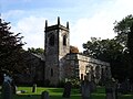
 / 52.91679; -1.31573 (All Saints' Church)
All Saints, Risley - geograph.org.uk - 990045.jpg
1593The north aisle and vestry were added in 1841. The church is built in stone and has a slate roof behind parapets. It consists of a combined nave and chancel, a large north aisle and vestry, and a west tower. The tower has two stages, the upper stage slightly corbelled out. In the bottom stage is a small lancet window on the west side, and the upper stage contains bell openings with four-centred arches and two lights, and a hood mould. Above is a moulded string course, parapets with chamfered copings, and corner pinnacles. The south doorway has a four-centred arch, a moulded surround and a hood mould, and above it is a plaque with a coat of arms and the date. [2] [3] II*
Balustrades, gateway and bridge, Risley Hall
52°54′55″N1°18′58″W / 52.91522°N 1.31609°W / 52.91522; -1.31609 (Balustrades, gateway and bridge, Risley Hall)
Bridge and gateway in grounds of Risley Hall (10).JPG
Early 17th centuryCrossing a stream in the garden is a stepped bridge and a gateway. The gateway has a doorway with a moulded surround and a four-centred arch and contains an iron gate. It is flanked by semicircular-headed niches with moulded arches, shield keystones and moulded capitals. Over it is a hood mould and a crowstepped gable with steeple finials. The balustrades have shaped splat balusters and piers with moulded edges, each pier with a pedestal and a finial. [4] [5] II*
Garden walls and gateway, Risley Hall
52°54′59″N1°18′59″W / 52.91625°N 1.31649°W / 52.91625; -1.31649 (Garden walls and gateway, Risley Hall)
Gabled Gateway at Risley Hall - geograph.org.uk - 3603088.jpg
Early 17th centuryThe gateway at the northern entrance to the grounds of the hall is in stone, and is set at an angle to the walls. It contains a four-centred arch with a moulded surround, over which is a large lintel and a moulded hood mould. Over this is a crowstepped gable with moulded ridgeback copings, and the gateway contains a pair of wooden gates. Flanking it are low stone garden walls with moulded ridgeback copings, stepping up near the gateway. [6] II
Brook House
52°55′03″N1°18′56″W / 52.91753°N 1.31562°W / 52.91753; -1.31562 (Brook House)
17th centuryA timber framed house on a stone plinth, largely rebuilt in red brick and whitewashed, and with a pantile roof. There is a single storey and attics, and three bays. On the front is a doorway with a divided fanlight, the windows are casements, above are two raking dormers, and in the east gable wall is a horizontally-sliding sash window. Inside the house is an inglenook fireplace. [7] II
Church Cottage
52°55′01″N1°18′57″W / 52.91694°N 1.31574°W / 52.91694; -1.31574 (Church Cottage)
Church Cottage - geograph.org.uk - 2536454.jpg
17th centuryThe cottage, which was partly rebuilt in 1888, is built partly in stone, partly in timber framing, and partly in red brick, and has a tile roof with overhanging eaves. There is a single storey and an attic, and two bays. The doorway and the windows have segmental heads, and above the doorway is a stone plaque with an inscription and date. Inside the cottage is an inglenook fireplace. [8] II
Risley Hall and wall
52°54′57″N1°19′02″W / 52.91578°N 1.31712°W / 52.91578; -1.31712 (Risley Hall and wall)
RisleyHall1.jpg
17th centuryA country house that has been extended, particularly in the 18th century, and later altered and used for other purposes. The earliest part is in stone on a chamfered plinth, with a continuous hood mould, and a tile roof. It has two storeys and six bays. The 18th-century wing is in red brick on a chamfered plinth, with floor bands, a sawtooth eaves band, and a hipped tile roof. There are two storeys and attics and six bays, and on the garden front is a Doric porch that has a fluted frieze with roundels, carried on columns and pilasters, and it has a semicircular-headed doorway with a traceried fanlight. On this front are two canted bay windows, and sash windows with rusticated wedge lintels and double keystones, and in the roof are four hipped dormers. At the rear of the range is a semicircular bay window, a doorway with a four-centred arch over which is a coat of arms and an embattled parapet, and mullioned and transomed windows. Attached to the house is a 17th-century garden wall with moulded copings. [9] [10] II
Latin House
52°55′00″N1°18′55″W / 52.91655°N 1.31536°W / 52.91655; -1.31536 (Latin House)
Latin House, Risley - geograph.org.uk - 990034.jpg
1706A schoolhouse, later a private house, it is in red brick with vitrified headers in the ground floor, on a brick plinth with chamfered stone copings, stone dressings, rusticated quoins, a floor band, a moulded stone cornice, and a hipped tile roof. There are two storeys, attics and a basement, and a square plan with fronts of five and four bays. Semicircular steps lead up to the central doorway that has a frieze containing an inscription and the date in Latin. Above this is a moulded broken segmental pediment on acanthus consoles, containing an achievement. The windows are sashes with moulded surrounds and carved keystones, and there is a frieze and hood mould over the ground floor windows. On the east and west fronts are pedimented dormers. [11] [12] II*
Churchyard walls, gates and war memorial, All Saints' Church
52°54′59″N1°18′57″W / 52.91646°N 1.31581°W
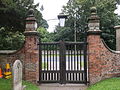
 / 52.91646; -1.31581 (Churchyard walls, gates and war memorial, All Saints' Church)
All Saints, Risley (gates, 02).JPG
1707Flanking the entrance to the churchyard are square brick gate piers, about 10 feet (3.0 m) high, each with a moulded stone cornice, and a pedestal on which is a ball finial with a moulded base. On the east arch is a dated brick, and between the piers are wooden gates, and an iron scrolled lantern arch and lantern. Attached to the piers are ramped curving brick walls on a chamfered plinth with rounded stone copings, and vitrified headers in a lozenge pattern. The walls continue to encircle the churchyard, and contain small abutments. To the left of the entrance is a stone war memorial that has a moulded square plinth with inscriptions relating to the two World Wars. Above is a tapering square pier with an inset dated square panel, and at the top is a moulded cornice. [11] [13] II
Latin College and the Latin Cottage
52°55′00″N1°18′54″W / 52.91669°N 1.31492°W / 52.91669; -1.31492 (Latin College and the Latin Cottage)
Latin Cottage, Risley (17).JPG
c. 1720A school, later divided into a schoolroom and a cottage, it is in red brick with sandstone dressings, on a sandstone plinth with chamfered copings, a stepped and dentilled eaves cornice, and a tile roof with rounded stone gable copings and brick kneelers. There is a single storey, a basement and attics, and four bays. Steps lead up to a central doorway in a flat-headed recess, that has a plain surround and a chamfered inner edge. It is flanked by tall windows with mullions and double transoms, and stone wedge lintels, over which are dentilled bands. [11] [14] II*
The Grammar School
52°55′00″N1°18′52″W / 52.91680°N 1.31442°W / 52.91680; -1.31442 (The Grammar School)
The Grammar School, Risley.jpg
c. 1720The former school is in red brick with sandstone dressings, on a sandstone plinth with chamfered copings, a stepped and dentilled eaves cornice, and a tile roof with rounded stone gable copings and brick kneelers. There is a single storey and attics, and four bays. Steps lead up to a central doorway in a flat-headed recess, that has a plain surround and a chamfered inner edge. It is flanked by tall windows with mullions and double transoms, and stone wedge lintels. [11] [15] II
The Old School House
52°55′01″N1°18′53″W / 52.91686°N 1.31476°W / 52.91686; -1.31476 (The Old School House)
The Old School House, Risley.jpg
c. 1720The school house, later a private house, is in red brick with yellow brick headers, gauged brick dressings, floor bands with vitrified headers, a stepped and dentilled eaves cornice, and a tile roof with moulded gable copings and plain kneelers. There are two storeys and attics, a T-shaped plan, and a front of five bays. The central doorway has a plain surround and a chamfered inner edge, and above it is a shell canopy. This is flanked by sash windows, and in the upper floor are casement cross windows. [11] [16] II*
Walls to front of Latin College and the Latin Cottage
52°55′00″N1°18′53″W / 52.91654°N 1.31483°W / 52.91654; -1.31483 (Walls to front of Latin College and the Latin Cottage)
Latin Cottage, Risley (18).JPG
Early 18th centuryThe walls enclosing the front garden are in red brick with rounded stone copings. There are brick piers in the centre and at the west end with rounded pyramidal copings, and at the east end is a pier with a stone pedestal and a cornice. [17] II
Pair of chest tombs
52°55′00″N1°18′57″W / 52.91659°N 1.31574°W / 52.91659; -1.31574 (Pair of chest tombs)
All Saints' Churchyard, Risley (01).JPG
Early 18th centuryThe chest tombs are in the churchyard of All Saints' Church, the later one dating from the middle of the 18th century. The tombs have sides in red brick, and each has a stone slab with moulded edges, and an inscription on the west end. The southern tomb has a pair of inscriptions, each set in a moulded panel, with an angel between the panels. [18] II
Pair of urns, Risley Hall
52°54′58″N1°19′01″W / 52.91598°N 1.31689°W / 52.91598; -1.31689 (Pair of urns, Risley Hall)
Urn, Risley Hall.jpg
Late 18th centuryIn the garden of the hall is a pair of matching stone urns about 12 feet (3.7 m) high. Each urn has a moulded square plinth with steps on each side, and a vase-shaped base. On this is a tall urn, gadrooned at the base, with floral swags to the neck, and a fluted gadrooned top, on which is a fruit bowl finial. [19] II
Risleyhall Farmhouse and barn
52°54′48″N1°18′55″W / 52.91340°N 1.31531°W / 52.91340; -1.31531 (Risleyhall Farmhouse and barn)
1806The farmhouse is in rendered brick with a dentilled eaves band and a hipped slate roof. There are three storeys and three bays. The central doorway and the windows, which are casements, have segmental heads. The attached barn is in stone with red brick at the top, and has quoins, a dentilled eaves band and a slate roof. It contains a central opening flanked by slit vents, and on the south side is a 19th-century pump. [20] II
Milepost (east)
52°55′01″N1°18′46″W / 52.91699°N 1.31283°W / 52.91699; -1.31283 (Milepost (east))
Old Milepost by the B5010 in Risley (geograph 5623807).jpg
Early 19th centuryThe milepost on the north side of Derby Road (B5010 road) is in cast iron, and about 3 feet (0.91 m) high. It has a narrow circular stem, a wider cylindrical head, and a moulded top. The milepost is inscribed with the distances to Nottingham and Derby, and on the stem are details of the manufacturer. [21] II
Milepost (west)
52°54′59″N1°19′59″W / 52.91634°N 1.33310°W / 52.91634; -1.33310 (Milepost (west))
Old Milepost by the B5010, west of Risley (geograph 5623806).jpg
Early 19th centuryThe milepost on the north side of Derby Road (B5010 road) is in cast iron, and about 3 feet (0.91 m) high. It has a narrow circular stem, a wider cylindrical head, and a moulded top. The milepost is inscribed with the distances to Nottingham and Derby, and on the stem are details of the manufacturer. [22] II

Related Research Articles

Alfreton is a civil parish and a town in the Amber Valley district of Derbyshire, England. The parish contains 18 listed buildings that are recorded in the National Heritage List for England. Of these, one is listed at Grade II*, the middle of the three grades, and the others are at Grade II, the lowest grade. The listed buildings include two churches, a chest tomb and a sundial in a churchyard, houses and associated structures, a former village lock-up, a hotel, a milepost, a school and a war memorial.

Aston is a civil parish in the High Peak district of Derbyshire, England. The parish contains three listed buildings that are recorded in the National Heritage List for England. All the listed buildings are designated at Grade II, the lowest of the three grades, which is applied to "buildings of national importance and special interest". The parish contains the village of Aston, and is otherwise rural. The listed buildings consist of a house, a farmhouse and an outbuilding combined into a house, and a milepost.

Castleton is a civil parish in the High Peak district of Derbyshire, England. The parish contains 25 listed buildings that are recorded in the National Heritage List for England. Of these, one is listed at Grade I, the highest of the three grades, one is at Grade II*, the middle grade, and the others are at Grade II, the lowest grade. The parish contains the village of Castleton and the surrounding countryside and moorland. The most important building in the parish is the ruined Peveril Castle, which is listed at Grade I. The other listed buildings include houses, cottages and associated structures, farmhouses and farm buildings, a church and a sundial in the churchyard, a hotel and a public house, a former watermill, three mileposts, a school, a war memorial, and a telephone kiosk.

Denby is a civil parish in the Amber Valley district of Derbyshire, England. The parish contains nine listed buildings that are recorded in the National Heritage List for England. Of these, one is listed at Grade I, the highest of the three grades, two are at Grade II*, the middle grade, and the others are at Grade II, the lowest grade. The parish contains the village of Denby and the surrounding area. The listed buildings consist of a church, a tombstone and a war memorial in the churchyard, farmhouses and associated structures, and a milepost.

Draycott and Church Wilne is a civil parish in the Borough of Erewash district of Derbyshire, England. The parish contains 17 listed buildings that are recorded in the National Heritage List for England. Of these, one is listed at Grade I, the highest of the three grades, and the others are at Grade II, the lowest grade. The parish contains the village of Draycott, the hamlet of Church Wilne, and the surrounding countryside. Most of the listed buildings are mill buildings in Draycott village, and the others consist of houses and associated structures, a church, a milepost, and three railway bridges.

Elvaston is a civil parish in the South Derbyshire district of Derbyshire, England. The parish contains 28 listed buildings that are recorded in the National Heritage List for England. Of these, one is listed at Grade I, the highest of the three grades, one is at Grade II*, the middle grade, and the others are at Grade II, the lowest grade. The parish contains the village of Elvaston and the surrounding area, including the country house Elvaston Castle, which is listed, together with associated structures and buildings in its grounds. The other listed buildings are houses and cottages, a church and associated structures, two mileposts, a former school and schoolmaster's house, and a war memorial.

Hartington Nether Quarter is a civil parish in the Derbyshire Dales district of Derbyshire, England. The parish contains 24 listed buildings that are recorded in the National Heritage List for England. Of these, one is listed at Grade II*, the middle of the three grades, and the others are at Grade II, the lowest grade. The parish is mainly rural, to the east of the village of Hartington, and it contains the settlements of Biggin, Friden, Heathcote, Newhaven and Pikehall. Most of the listed buildings are houses, cottages, farmhouses, and associated structures, and the others are a hotel, a church, and two mileposts.

Horsley and Horsley Woodhouse are civil parishes in the Amber Valley district of Derbyshire, England. The parishes contain eight listed buildings that are recorded in the National Heritage List for England. Of these, one is listed at Grade I, the highest of the three grades, and the others are at Grade II, the lowest grade. The parishes contain the villages of Horsley and Horsley Woodhouse and the surrounding area. The listed buildings consist of a church, a cottage, a farmhouse and farm buildings, the remains of buildings in the garden of a demolished house, a milepost, a water fountain, and a former post box.

Kedleston is a civil parish in the Amber Valley district of Derbyshire, England. The parish contains 19 listed buildings that are recorded in the National Heritage List for England. Of these, four are listed at Grade I, the highest of the three grades, eight are at Grade II*, the middle grade, and the others are at Grade II, the lowest grade. The parish contains the village of Kedleston and the surrounding area. The major building in the parish is Kedleston Hall, which is listed together with associated structures, including a church, and buildings in the gardens and surrounding park. The listed buildings outside the park are a rectory, a smithy converted into a private house, and a milepost.

Kirk Langley is a civil parish in the Amber Valley district of Derbyshire, England. The parish contains 18 listed buildings that are recorded in the National Heritage List for England. Of these, one is listed at Grade I, the highest of the three grades, and the others are at Grade II, the lowest grade. The parish contains the village of Kirk Langley and the surrounding countryside. Most of the listed buildings are houses and associated structures, and farmhouses. The other listed buildings include a church, a cross in the churchyard, a memorial hall, a boundary post, and a milepost.

Mackworth is a civil parish in the Amber Valley district of Derbyshire, England. The parish contains 14 listed buildings that are recorded in the National Heritage List for England. Of these, two are listed at Grade I, the highest of the three grades, and the others are at Grade II, the lowest grade. The parish consists of the village of Mackworth and the surrounding area, The listed buildings consist of a church with associated structures, a ruined gatehouse, houses, cottages and farmhouses, a boundary post and a milepost, and a school.

Quarndon is a civil parish in the Amber Valley district of Derbyshire, England. The parish contains ten listed buildings that are recorded in the National Heritage List for England. Of these, one is listed at Grade II*, the middle of the three grades, and the others are at Grade II, the lowest grade. The parish contains the village of Quarndon and the surrounding countryside. The listed buildings consist of the remains of a former church, a current church and items in the churchyard, a hotel, an iron screen, a barn, houses, a well house and a milepost.

Sandiacre is a civil parish in the Borough of Erewash in Derbyshire, England. The parish contains ten listed buildings that are recorded in the National Heritage List for England. Of these, one is listed at Grade I, the highest of the three grades, and the others are at Grade II, the lowest grade. The parish contains the village of Sandiacre and the surrounding area. The listed buildings consist of a church, a village lock-up and pound, two bridges crossing the Erewash Canal, a house, a milepost, a former lace factory and its office block, and two pairs of almshouses.

Sheldon is a civil parish in the Derbyshire Dales district of Derbyshire, England. The parish contains five listed buildings that are recorded in the National Heritage List for England. All the listed buildings are designated at Grade II, the lowest of the three grades, which is applied to "buildings of national importance and special interest". The parish contains the village of Sheldon and the surrounding countryside. The listed buildings consist of a cottage with attached outbuildings, a house, a church, and two buildings associated with a bobbin mill.

South Normanton is a civil parish in the Bolsover District of Derbyshire, England. The parish contains eight listed buildings that are recorded in the National Heritage List for England. Of these, two are listed at Grade II*, the middle of the three grades, and the others are at Grade II, the lowest grade. The parish contains the village of South Normanton and the surrounding area, and the listed buildings consist of a country house and its coach house, a church, a former windmill, a former farmhouse, a school and two mileposts.

Swarkestone is a civil parish in the South Derbyshire district of Derbyshire, England. The parish contains 19 listed buildings that are recorded in the National Heritage List for England. Of these, one is listed at Grade I, the highest of the three grades, three are at Grade II*, the middle grade, and the others are at Grade II, the lowest grade. The parish contains the village of Swarkestone and the surrounding area. The Trent and Mersey Canal passes through the northern part of the parish, and the listed buildings associated with it are bridges, a lock, mileposts, and a former toll house with an outbuilding. The other listed buildings include houses and associated structures, farmhouses and farm buildings, a church and a cross in the churchyard, a public house and its former stable block, and former reading rooms.

Taddington is a civil parish in the Derbyshire Dales district of Derbyshire, England. The parish contains 13 listed buildings that are recorded in the National Heritage List for England. Of these, one is listed at Grade I, the highest of the three grades, and the others are at Grade II, the lowest grade. The parish contains the village of Taddington and the surrounding countryside. Most of the listed buildings are farmhouses and farm buildings, and the others consist of a house, a church, three mileposts, a railway viaduct, and a row of lime kilns.

Weston Underwood is a civil parish in the Amber Valley district of Derbyshire, England. The parish contains 16 listed buildings that are recorded in the National Heritage List for England. Of these, two are listed at Grade I, the highest of the three grades, one is at Grade II*, the middle grade, and the others are at Grade II, the lowest grade. The parish contains the villages of Weston Underwood and Mugginton and the surrounding area, including part of Kedleston Park. The listed buildings in the park are a bridge and a cascade, a Gothic temple, and a sawmill and engine houses. Elsewhere, they include houses, cottages and associated structures, farmhouses and farm buildings, a church and two mileposts.

Weston-on-Trent is a civil parish in the South Derbyshire district of Derbyshire, England. The parish contains twelve listed buildings that are recorded in the National Heritage List for England. Of these, one is listed at Grade I, the highest of the three grades, one is at Grade II*, the middle grade, and the others are at Grade II, the lowest grade. The parish contains the village of Weston-on-Trent and the surrounding area. The Trent and Mersey Canal passes through the parish, and the listed buildings associated with it are bridges, a lock and mileposts. The other listed buildings are a church and houses.

Wingerworth is a civil parish in the North East Derbyshire district of Derbyshire, England. The parish contains 20 listed buildings that are recorded in the National Heritage List for England. Of these, one is listed at Grade I, the highest of the three grades, one is at Grade II*, the middle grade, and the others are at Grade II, the lowest grade. The parish contains the village of Wingerworth and the surrounding countryside. Most of the listed buildings are houses, cottages and associated structures, farmhouses and farm buildings. The other listed buildings include churches, a public house, a pair of lodges and associated structures, two mileposts, and a bridge with an associated sheepwash.

References

Citations

Sources