Listed buildings in Shipley, Derbyshire

Last updated

Shipley is a civil parish in the Amber Valley district of Derbyshire, England. The parish contains twelve listed buildings that are recorded in the National Heritage List for England. Of these, one is listed at Grade II*, the middle of the three grades, and the others are at Grade II, the lowest grade. The parish contains the village of Shipley and the surrounding area. The most important building in the parish was Shipley Hall, but this was demolished in 1948. [1] A number of buildings in its grounds are listed, including a model farm, a former water tower, a house, and two lodges with their associated gateways. The Erewash Canal passes through the parish and the listed buildings associated with it are a bridge, a lock and a cottage. The other listed buildings are two road bridges to the south of Shipley Lake.

Contents

Key

Map all coordinates using: OpenStreetMap  
Download coordinates as: KML
GradeCriteria [2]
II*Particularly important buildings of more than special interest
IIBuildings of national importance and special interest

Buildings

Name and locationPhotographDateNotesGrade
Colliery Road Bridge
52°59′26″N1°20′13″W / 52.99047°N 1.33689°W
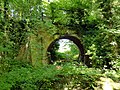
 / 52.99047; -1.33689 (Colliery Road Bridge)
Colliery Road Bridge, Shipley Park.jpg
Late 18th centuryThe road bridge to the south of Shipley Reservoir is in sandstone with brick under the arch. It consists of a single semicircular arch with rusticated voussoirs, on raised impost locks, on a stone base. Above is a plain band and parapets. [3] II
Paul's Arm Bridge
52°59′25″N1°20′22″W / 52.99033°N 1.33945°W / 52.99033; -1.33945 (Paul's Arm Bridge)
Paul's Arm Bridge.jpg
Late 18th centuryThe road bridge to the south of Shipley Reservoir is in sandstone and brick. It consists of two semicircular arches with rusticated voussoirs, and a central pier with triangular cutwaters. Above the arch is a plain band and parapets, and the side walls curve outwards and end in square piers. [4] II
The Cottage, Shipley Gate Lock
53°00′13″N1°18′43″W / 53.00353°N 1.31193°W
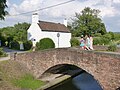
 / 53.00353; -1.31193 (The Cottage, Shipley Gate Lock)
Bridge and canalside cottage at Shipley Gate - geograph.org.uk - 3556757.jpg
Late 18th centuryA pair of cottages combined into one, it is in rendered brick with a pantile roof. There are two storeys, two bays, a gabled projection to the east, and a lean-to south porch. The cottage contains a segmental-headed opening and sash windows, one of which is horizontally-sliding. [5] II
Canal bridge at Shipley Gate
53°00′13″N1°18′44″W / 53.00349°N 1.31217°W / 53.00349; -1.31217 (Canal bridge at Shipley Gate)
Canal Bridge - geograph.org.uk - 2972699.jpg
1779The bridge carries Long Lane over the Erewash Canal. It is in red brick with stone copings, and consists of a single low segmental arch. The bridge has low brick parapets, and the side walls splay outwards and end in square brick piers. [6] II
Lock, lock gates and basin at Shipley Gate
53°00′13″N1°18′45″W / 53.00362°N 1.31250°W / 53.00362; -1.31250 (Lock, lock gates and basin at Shipley Gate)
Shipley Lock.jpg
1779The lock on the Erewash Canal has a basin in sandstone and red brick with stone copings, and the gates are in wood and reinforced in metal. The gates have wooden balance beams with metal handrails and rack and pinion mechanisms to either side, there are semi-circular footholds, and on the sides are bollards. On the north side is a metal ladder. [7] II
Home Farmhouse and farm buildings
52°59′38″N1°21′05″W / 52.99393°N 1.35147°W / 52.99393; -1.35147 (Home Farmhouse and farm buildings)
Home Farm, Shipley Hall.jpg
1860–61A model farm designed by W. E. Nesfield for the former Shipley Hall. The buildings are in red brick with sandstone dressings, bands in sandstone and buff brick, plinths with blue brick copings, tile roofs with geometric designs in red tiles and blue tile banding, and crested ridge tiles. The farmhouse has a single storey and attics, and a square tower at the northeast corner. The farm buildings include an octagonal dairy, a north range of pigsties and cowsheds, and a west range of stables with a large central carriage arch, at the south end of which is a circular dovecote with a conical roof and a sunburst finial. [1] [8] II*
The Gardens
52°59′37″N1°21′08″W / 52.99353°N 1.35224°W / 52.99353; -1.35224 (The Gardens)
The Gardens, Shipley.jpg
1882A house, later offices, in red brick with stone dressings, quoins, and floor bands. The upper floor is jettied and timber framed with brick nogging, and with plaster infill in the gables. The roof is tiled, with overhanging eaves and gables with bargeboards. There are two storeys and fronts of two bays. The east front has two gables and contains a bow window. In the west gable is a plaster plaque with a crest, initials and the date. Most of the windows are mullioned and have four-centred arched lights and incised spandrels. On the south front is an open gabled porch with a four-centred arch on octagonal piers and carved spandrels, and a doorway with a four-centred arched head. [1] [9] II
Former water tower
52°59′37″N1°21′03″W / 52.99368°N 1.35092°W / 52.99368; -1.35092 (Former water tower)
Converted water tower at Shipley Hall - geograph.org.uk - 1995367.jpg
1892The water tower, later used for other purposes, is in the grounds of the former Shipley Hall, and was extended in about 1920. The original tower is octagonal, in stone, with four storeys, quoins, a coped plinth, a moulded eaves band, and a moulded cornice. The extension is circular with five storeys, in red brick, with brown brick sawtooth bands between the storeys, and with a conical wooden roof. Between the towers are glazed wooden screens. In the east front of the original tower are mullioned windows with semicircular-headed lights, and a stone plaque with a crest, initials and the date, and in the north front is a doorway. [1] [10] II
Derby Lodge
52°59′45″N1°21′08″W / 52.99570°N 1.35212°W / 52.99570; -1.35212 (Derby Lodge)
Derby Lodge, Shipley Park.jpg
c. 1903A lodge to the former Shipley Hall, which was designed by Walter Tapper in Tudor style, is in sandstone, and has a stone slate cruciform roof with chamfered stone gable copings on plain kneelers. There is a single storey and attics, and a square plan with a single gabled bay on each side. On each corner is a semicircular arch with a moulded arch. In the eastern arch is a doorway with a moulded surround, and the windows are mullioned. The western gable contains a plaque with a rusticated surround containing a coat of arms, and in the other gables are ventilation slits. [1] [11] II
Western gatepiers and walls,
Derby Lodge
52°59′44″N1°21′08″W / 52.99567°N 1.35225°W
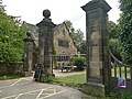
 / 52.99567; -1.35225 (Western gatepiers and walls, Derby Lodge)
Gateway, Derby Lodge, Shipley Park.jpg
c. 1903The gate piers and walls, designed by Walter Tapper, are in sandstone. The central piers are square, about 15 feet (4.6 m) high, and each pier has a moulded base and cornice, inset panels on the east and west sides, broad pilaster strips with scrolled tops on the north and south sides, and a ball finial. They are flanked by similar smaller piers, and between them are pairs of wooden gates. Attached to the smaller piers are stone coped walls which curve and end in square piers, and there are further sections of walls beyond. [12] II
Nottingham Lodge
52°59′39″N1°20′46″W / 52.99415°N 1.34599°W / 52.99415; -1.34599 (Nottingham Lodge)
Nottingham Lodge, Shipley Park.jpg
c. 1903A lodge to the former Shipley Hall, which was designed by Walter Tapper in Tudor style, is in sandstone, and has a stone slate cruciform roof with chamfered stone gable copings on plain kneelers. There is a single storey and attics, and a square plan with a single gabled bay on each side. On each corner is a semicircular arch with a moulded arch. In the western arch is a doorway with a moulded surround, and the windows are mullioned. The western gable contains a plaque with a rusticated surround containing a coat of arms, and in the other gables are ventilation slits. [1] [13] II
Gatepiers and wall,
Nottingham Lodge
52°59′39″N1°20′45″W / 52.99430°N 1.34591°W
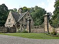
 / 52.99430; -1.34591 (Gatepiers and wall, Nottingham Lodge)
Gateway, Nottingham Lodge, Shipley Park.jpg
c. 1903The gate piers and walls, designed by Walter Tapper, are in sandstone. The piers are tall and square, and each pier has a moulded base and cornice, broad pilasters on the sides with scrolled tops, and a ball finial, and between them are wooden gates. The walls have stone copings, and curve in a semicircle, with smaller square piers at the ends, and there are further sections of walls beyond. [14] II

Related Research Articles

Mellor is a civil parish in Ribble Valley, Lancashire, England. It contains ten listed buildings that are recorded in the National Heritage List for England. Of these, one is at Grade II*, the middle grade, and the others are at Grade II, the lowest grade. The parish contains the village of Mellor, and is otherwise rural. The only listed building in the village is the church. The other listed buildings are houses and associated structures, farmhouses, and a bridge.

Alderwasley is a civil parish in the Amber Valley district of Derbyshire, England. The parish contains 16 listed buildings that are recorded in the National Heritage List for England. All the listed buildings are designated at Grade II, the lowest of the three grades, which is applied to "buildings of national importance and special interest". The parish contains the village of Alderwasley and the surrounding countryside. The listed buildings consist of houses and associated structures, farmhouses, a country house converted into a school, a church and a former chapel, a public house, a road bridge, a milestone, a former toll house, and a war memorial.

Barlborough is a civil parish in the Bolsover district of Derbyshire, England. The parish contains 29 listed buildings that are recorded in the National Heritage List for England. Of these, one is listed at Grade I, the highest of the three grades, six are at Grade II*, the middle grade, and the others are at Grade II, the lowest grade. The parish contains the village of Barlborough and the surrounding area. The listed buildings include two country houses, smaller houses and associated structures, a church, a village cross, farmhouses and farm buildings, a former almshouse, two monuments in a garden, the walls of a burial ground, a memorial gateway, and a school.

Barlow is a civil parish in the North East Derbyshire district of Derbyshire, England. The parish contains 18 listed buildings that are recorded in the National Heritage List for England. Of these, three are listed at Grade II*, the middle of the three grades, and the others are at Grade II, the lowest grade. The parish contains the village of Burton and the surrounding countryside, mainly to the west of the village. It is almost entirely rural, and the listed buildings are mainly houses and associated structures, farmhouses and farm buildings. The other listed buildings are a church, its former rectory, a bridge, a former school, a pinfold, and a village pump.

Brampton is a civil parish in the North East Derbyshire district of Derbyshire, England. The parish contains 37 listed buildings that are recorded in the National Heritage List for England. Of these, one is listed at Grade I, the highest of the three grades, three are at Grade II*, the middle grade, and the others are at Grade II, the lowest grade. The parish contains the villages of Cutthorpe, Old Brampton, and Wadshelf, and the surrounding countryside. Most of the listed buildings are houses and associated structures, farmhouses and farm buildings. The other listed buildings include a church, a chapel, and two guide posts.

Brimington is a civil parish in the Borough of Chesterfield, Derbyshire, England. The parish contains 14 listed buildings that are recorded in the National Heritage List for England. Of these, one is listed at Grade II*, the middle of the three grades, and the others are at Grade II, the lowest grade. The parish contains the village of Brimington and the surrounding area, and the listed buildings consist of houses and associated structures, a church, part of a school, and a set of war memorial gates.

Dale Abbey is a civil parish in the Erewash district of Derbyshire, England. The parish contains 20 listed buildings that are recorded in the National Heritage List for England. Of these, three are listed at Grade I, the highest of the three grades, one is at Grade II*, the middle grade, and the others are at Grade II, the lowest grade. The parish contains the village of Dale Abbey and the surrounding area. The village gets its name from the abbey of the same name, which is in ruins. The abbey ruins are listed, together with buildings in the village, including houses, farmhouses and farm buildings, and a church with an attached house. To the north of the village is a post mill, which is listed together with two associated buildings. To the west of the village is Locko Park, a country house, which is listed together with associated structures and items in its grounds.

Dethick, Lea and Holloway is a civil parish in the Amber Valley district of Derbyshire, England. The parish contains 36 listed buildings that are recorded in the National Heritage List for England. Of these, five are listed at Grade II*, the middle of the three grades, and the others are at Grade II, the lowest grade. The parish contains the villages of Dethick, Lea, and Holloway, and the surrounding area. Most of the listed buildings are country houses, smaller houses, cottages, and associated structures. The other listed buildings include churches and chapels, a public house, farmhouses and farm buildings, and a bridge.

Long Eaton is a town and unparished area in the Borough of Erewash in Derbyshire, England. The town and the surrounding area contain 31 listed buildings that are recorded in the National Heritage List for England. Of these, two are listed at Grade II*, the middle of the three grades, and the others are at Grade II, the lowest grade. The Erewash Canal and the Cranfleet Canal pass through the area, and the listed buildings associated with them are bridges, locks, and a lockkeeper's cottage. The other listed buildings include houses and associated structures, churches and a Sunday school, a set of park gates, a college chapel, commercial buildings, cemetery buildings, a library, schools designed by G. H. Widdows, and a war memorial.

Ilkeston is a town and unparished area in the Borough of Erewash in Derbyshire, England. The town and surrounding area contain 28 listed buildings that are recorded in the National Heritage List for England. Of these, one is listed at Grade I, the highest of the three grades, three are at Grade II*, the middle grade, and the others are at Grade II, the lowest grade. The Erewash Canal passes through the area, and the listed buildings associated with it are two bridges and two locks. The other listed buildings include churches and a chapel, a church tower, houses, a museum, the town hall, two factories, a drinking fountain, a brick kiln, a library, cemetery buildings, two cinemas, a school, and two war memorials.

Etwall is a civil parish in the South Derbyshire district of Derbyshire, England. The parish contains 16 listed buildings that are recorded in the National Heritage List for England. Of these, one is listed at Grade I, the highest of the three grades, two are at Grade II*, the middle grade, and the others are at Grade II, the lowest grade. The parish contains the village of Etwall and the surrounding area, and all the listed buildings are in the village. Most of them are houses and associated structures, and the others include a church, a group of almshouses and its gateway, a public house, and a well head.

Holbrook is a civil parish in the Amber Valley district of Derbyshire, England. The parish contains 14 listed buildings that are recorded in the National Heritage List for England. Of these, one is listed at Grade II*, the middle of the three grades, and the others are at Grade II, the lowest grade. The parish contains the village of Holbrook, the hamlet of Coxbench, and the surrounding area. Most of the listed buildings are houses, cottages and associated structures, farmhouses and farm buildings. The other listed buildings include a church and associated structures, and two former stocking frame knitter's workshops.

Holmesfield is a civil parish in the North East Derbyshire district of Derbyshire, England. The parish contains 41 listed buildings that are recorded in the National Heritage List for England. Of these, five are listed at Grade II*, the middle of the three grades, and the others are at Grade II, the lowest grade. The parish contains the village of Holmesfield, the hamlet of Cartledge, and the surrounding countryside and moorland. Most of the listed buildings are houses, cottages and associated structures, farmhouses, and farm buildings. The other listed buildings include two medieval crosses, a cross dated 1619, a church, public houses, a former toll house, a milepost, and two milestones.

Hopton is a civil parish in the Derbyshire Dales district of Derbyshire, England. The parish contains 21 listed buildings that are recorded in the National Heritage List for England. All the listed buildings are designated at Grade II, the lowest of the three grades, which is applied to "buildings of national importance and special interest". The parish contains the village of Hopton and the surrounding countryside. Most of the listed buildings are houses, cottages and associated structures, farmhouses and farm buildings. The other listed buildings include a guide post, a row of almshouses, the base of a former windmill, a well, and a railway bridge.

Longford is a civil parish in the Derbyshire Dales district of Derbyshire, England. The parish contains 22 listed buildings that are recorded in the National Heritage List for England. Of these, one is listed at Grade I, the highest of the three grades, four are at Grade II*, the middle grade, and the others are at Grade II, the lowest grade. The parish contains the village of Longford and the surrounding area. The major building in the parish is Longford Hall, which is listed, together with associated structures, and the adjacent farm and farm buildings. The other listed buildings include a church, a cross and tombs in the churchyard, houses and cottages, farmhouses, a row of almshouses, now in ruins, two bridges, a former watermill, and a former cheese factory.

Repton is a civil parish in the South Derbyshire district of Derbyshire, England. The parish contains 53 listed buildings that are recorded in the National Heritage List for England. Of these, six are listed at Grade I, the highest of the three grades, one is at Grade II*, the middle grade, and the others are at Grade II, the lowest grade. The parish contains the village of Repton, the smaller village of Milton, and the surrounding area. The major complex of buildings is associated with Repton School, built on the site of an earlier priory. Many of these are listed, four of them at Grade I. The other Grade I listed buildings are St Wystan's Church and the market cross. Most of the other listed buildings are houses, cottages and associated structures, the earlier ones timber framed, and the later ones in red brick. The rest of the listed buildings include farmhouses and farm buildings, bridges, a water management system, a war memorial, and a telephone, kiosk.

Ripley is a civil parish in the Amber Valley district of Derbyshire, England. The parish contains 62 listed buildings that are recorded in the National Heritage List for England. Of these, five are listed at Grade II*, the middle of the three grades, and the others are at Grade II, the lowest grade. The parish contains the town of Ripley, smaller settlements including Ambergate, Bullbridge, Butterley, Fritchley, Heage, Nether Heage and Waingroves, and the surrounding countryside. The Cromford Canal, now partly closed, runs through the parish, and the listed buildings associated with it are bridges and an embankment. Also running through the parish is a railway that originated as the North Midland Railway with a later branch, the Manchester, Buxton, Matlock and Midland Junction Railway, and associated with these are bridges, viaducts, a goods shed, and the portals of a tunnel. Most of the other listed buildings are houses, cottages and associated structures, farmhouses and farm buildings. The other listed buildings include churches, a windmill, a pair of coke iron furnaces, factory buildings, public houses, mileposts, colliery buildings, a railway station and signal box at Butterley, and a war memorial.

Risley is a civil parish in the Borough of Erewash in Derbyshire, England. The parish contains 17 listed buildings that are recorded in the National Heritage List for England. Of these, five are listed at Grade II*, the middle of the three grades, and the others are at Grade II, the lowest grade. The parish contains the village of Risley and the surrounding area. The listed buildings include a country house and structures in its grounds, a church and items in the churchyard, smaller houses, buildings associated with a school, a farmhouse and barn, and two mileposts.

Sandiacre is a civil parish in the Borough of Erewash in Derbyshire, England. The parish contains ten listed buildings that are recorded in the National Heritage List for England. Of these, one is listed at Grade I, the highest of the three grades, and the others are at Grade II, the lowest grade. The parish contains the village of Sandiacre and the surrounding area. The listed buildings consist of a church, a village lock-up and pound, two bridges crossing the Erewash Canal, a house, a milepost, a former lace factory and its office block, and two pairs of almshouses.

Shardlow and Great Wilne is a civil parish in the South Derbyshire district of Derbyshire, England. The parish contains 48 listed buildings that are recorded in the National Heritage List for England. Of these, one is listed at Grade II*, the middle of the three grades, and the others are at Grade II, the lowest grade. The parish contains the village of Shardlow, the smaller village of Great Wilne, and the surrounding area. Shardlow is at the southern end of the Trent and Mersey Canal, and a number of buildings relating to the canal are listed, including warehouses, mileposts, a bridge and a lock. Most of the other listed buildings are houses, cottages and associated structures, farmhouses and farm buildings. The rest of the listed buildings include public houses, a church and associated structures including a war memorial, a road milepost, the sign from a former toll house, and a school.

References

Citations

Sources