
Tanat Valley Light Railway & Llanfyllin Branch | ||||||||||||||||||||||||||||||||||||||||||||||||||||||||||||||||||||||||||||||||||||||||||||||||||||||||||||||||||||||||||||||||||||||||||||||||||||||||||||
|---|---|---|---|---|---|---|---|---|---|---|---|---|---|---|---|---|---|---|---|---|---|---|---|---|---|---|---|---|---|---|---|---|---|---|---|---|---|---|---|---|---|---|---|---|---|---|---|---|---|---|---|---|---|---|---|---|---|---|---|---|---|---|---|---|---|---|---|---|---|---|---|---|---|---|---|---|---|---|---|---|---|---|---|---|---|---|---|---|---|---|---|---|---|---|---|---|---|---|---|---|---|---|---|---|---|---|---|---|---|---|---|---|---|---|---|---|---|---|---|---|---|---|---|---|---|---|---|---|---|---|---|---|---|---|---|---|---|---|---|---|---|---|---|---|---|---|---|---|---|---|---|---|---|---|---|---|
| ||||||||||||||||||||||||||||||||||||||||||||||||||||||||||||||||||||||||||||||||||||||||||||||||||||||||||||||||||||||||||||||||||||||||||||||||||||||||||||
The Llanfyllin Branch was a railway line extension of the Oswestry and Newtown Railway to access the limestone resources within the Llanfyllin area; it opened in 1863.
Surveyed and engineered by a Mr Savin and his brother-in-law, Mr Ward, a stipulation of the authorising Act of Parliament was that the railway should not interfere with the existing access rights of: tramways of the mines; the Ellesmere Canal company branch; or the Tanat Valley Light Railway (TVLR). This necessitated the construction of two bridges on what was a relatively flat valley floor. [1]
Branching off from the former Oswestry and Newtown Railway at Llanymynech station, the lines access was to the north of the station to provide sufficient clearance height before crossing the canal. Unable to justify the expense of an aqueduct to pass under the canal, trains would hence proceed up what was called the "Rock Siding" towards the Hoffmann kilns, before reversing onto the Llanfyllin branch. [2]
After crossing the canal, the Llanfyllin branch diverged north on the loopline through Carreghofa Halt, before branching southwest before the junction of the loopline with the TVLR. The Nantmawr Branch was next on the loopline, while the Porth-y-waen branch was after the station at Porthywaen Halt, in fact not much more than a siding to serve the Porth-y-waen limestone quarry. The loopline then accessed the O&NR again, this time merging north via Llynclys junction towards Weston Wharf and onwards to the companies headquarters in the station at Oswestry. [3]
After leaving the loopline, the Llanfyllin branch passed through: Llansantffraid; Llanfechain; Bryngwyn; before terminating at Llanfyllin. [3]
The last piece of transport to arrive in Llanymynech was the Potteries, Shrewsbury and North Wales Railway (Potts), which ran from Shrewsbury Abbey. To access the Nantmawr branch for similar mineral extraction purposes, it ran under the O&NR via a bridge, and the canal via an aqueduct.
However, the Potts ran into financial difficulties, and services were suspended in June 1880. On 28 January 1881 the CR came to an agreement with the Potts receiver and its Chief Engineer Richard Samuel Francis (who also owned the mineral rights along the Nantmawr valley), [4] to maintain the stunted Nantmawr branch. The Cambrian would pay a royalty of 3d per ton, which was renewed but the toll was reduced to 2d a ton in January 1886. [4]
On 11 April 1894 the CR agreed to build a 0.5-mile (0.80 km) deviation from the Llanfyllin branch to join the Nantmawr line at Wern. This enabled the CR to access the Potts aqueduct under the canal, and hence stop use of the "Rock Siding" with immediate effect. [5] The CR also agreed to junction the Potts on the level with the CR mainline north of Llanymynech station. The Nantmawr branch reopened as a Cambrian subsidiary on 1 January 1896, and the deviation to the Llanfyllin branch followed on 27 January. A lease for 99 years followed on 12 April 1900, with the CR paying £555 a year: half itself, half from the TVLR which opened on 5 January 1904. [4]
The "Rock Siding" continued to serve the kilns until their closure in 1914, after which it was used to store redundant wagons, until the siding was removed in 1939. [2]

The line opened for operations from 10 April 1863. [1] It was worked by typical CR motive power of 0-6-0 and GWR 2301 Class "Dean Goods" up till the mid-1950s after which Ivatt Class 2 locomotives of the 46503–46527 series were almost exclusively used. Operations on the line were controlled by signal boxes at: Llanymynech; Llansantffraid; and Llanfyllin. [6]
After being controlled by the Great Western Railway from the Railways Act 1921, and then British Railways Western division from nationalisation in 1948 onwards, the former CR lines were vested to the London Midland Region of British Railways from 1963. The route from Llynclys junction south to Welshpool (Buttington Junction), closed on 18 January 1965.
The result was the simultaneous closure of the TVLR, as well as the Porthywaen and the Llanfyllin branches. A single line south from Oswestry to Llynclys junction enabled stone services to continue on the Nantmawr branch as far as Llanyblodwel quarry until 1988.
The line from Gobowen to Llanyblodwel remains in place, and forms the core revival plan of the Cambrian Heritage Railways to join with the enthusiast revived TVLR at Llanddu junction (Blodwel Quarry). Neither society has a plan at present to revive the Llanfyllin branch.

The Cambrian Railways owned 230 miles (370 km) of track over a large area of mid Wales. The system was an amalgamation of a number of railways that were incorporated in 1864, 1865 and 1904. The Cambrian connected with two larger railways with connections to the northwest of England via the London and North Western Railway, and the Great Western Railway for connections between London and Wales. The Cambrian Railways amalgamated with the Great Western Railway on 1 January 1922 as a result of the Railways Act 1921. The name is continued today in the route known as the Cambrian Line.
The Shropshire and Montgomeryshire Light Railway was a railway running from Shrewsbury, England to Llanymynech, Wales, with a branch to Criggion. It was promoted by Holman Fred Stephens, better known as Colonel Stephens, proprietor of several ultra-low budget light railways. It adopted the track network of the defunct Potteries, Shrewsbury and North Wales Railway that had closed in 1880; the S&MLR opened in 1911. Running through sparsely inhabited terrain, it struggled to achieve financial stability, and following a serious deterioration of maintenance conditions, it closed to passengers in 1933, continuing with a basic goods and mineral service.
The Potteries, Shrewsbury and North Wales Railway,, was a railway built between Shrewsbury, England, and quarry locations at Nantmawr and Criggion in Wales. It was initially opened in 1866; despite the extensive title it never reached further than those extremities. It had cost about £1.5 million to construct, but its financial performance was extremely poor, and economies resulted in near-suspension of maintenance, leading to dangerous conditions. The line rapidly became very run down as a result of low revenues and poor maintenance, and was closed at the instigation of the Board of Trade for safety reasons in June 1880. It lay derelict for 30 years but was revived when the Shropshire and Montgomeryshire Railway re-opened it as a light railway in 1911.

Llanymynech is a village and former civil parish straddling the border between Montgomeryshire/Powys, Wales, and Shropshire, England, about 9 miles (14 km) north of the Welsh town of Welshpool. The name is Welsh for "Church of the Monks". The village is on the banks of the River Vyrnwy, and the Montgomery Canal passes through it.

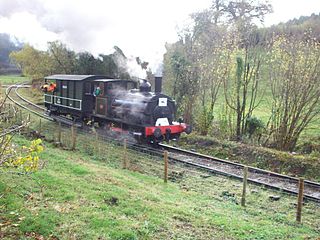
The Cambrian Heritage Railways is a heritage railway company, trust and society based at both Llynclys and Oswestry in its newly restored Oswestry railway station, Shropshire, England.

The English county of Shropshire has a fairly large railway network, with 19 National Rail stations on various national lines; there are also a small number of heritage and freight lines, including the famous heritage Severn Valley Railway running along its eastern border with Worcestershire.

Llynclys ) is a small village in Shropshire, England, in the civil parish of Llanyblodwel. It lies north of Pant at the crossroads of the A483 and B4396, where there are several houses and a pub, the White Lion.

Llansantffraid-ym-Mechain is a large village in Powys, Mid Wales, close to the border with Shropshire in England, about 7 miles (11 km) south-west of Oswestry and 8 miles (13 km) north of Welshpool. It is on the A495 road and is at the confluence of the River Vyrnwy and the River Cain. The population as of the 2011 UK census was 1,415. The community includes the village of Deuddwr and several hamlets.

Pant is a village in Shropshire, England. It lies near the border with Wales. Pant means 'hollow' in Welsh: it is located directly below the disused mines at Llanymynech Rocks Nature Reserve. The population at the 2011 census is listed under the Civil Parish of Llanymynech and Pant. The built-up area of Pant and Llanymynech is roughly 2,000.

Llanyblodwel and Pant was a ward in the county of Shropshire.
Penygarreg Lane is a halt on the Cambrian Heritage Railways' line in Shropshire. It is on the northern edge of the village of Pant, north of the disused Pant station. Prior to its construction, trains stopped here only to reverse back towards Llynclys and passengers could not board or alight here.
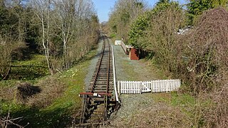
The Tanat Valley Light Railway (TVLR) was a 15-mile (24 km) long standard gauge light railway. It ran westwards from Llanyblodwel in Shropshire, about 5 miles or 8 km south-west of Oswestry. It crossed the Wales–England border and continued up the Tanat valley, terminating at Llangynog in Powys. It opened in 1904, providing access to a fairly remote area, and transport facilities for slate production and agriculture.

Llanyblodwel is a village and civil parish in Shropshire, England; the spelling "Llanyblodwell" was commonly used in the past, and the village was sometimes simply referred to as "Blodwel". The population of the civil parish at the 2011 census was 767. It lies 7 miles west of the nearest town, Oswestry, in the valley of the River Tanat. Simon Jenkins, in his guide to English churches says of Llanyblodwel that "the Welsh Marches are seldom so lovely as where the River Tanat crosses the border through the steep wooded valleys west of Oswestry."

Oswestry railway station is a Grade II listed heritage railway station in Oswestry, Shropshire, England. It was closed when passenger services were withdrawn in 1966. The station building today is used as commercial premises, although the Cambrian Railways Society are restoring it.
The Oswestry and Newtown Railway was a British railway company that built a line between Oswestry in Shropshire and Newtown Montgomeryshire, now Powys. The line opened in stages in 1860 and 1861. It was conceived to open up the area to rail transport, when local opinion formed the view that the trunk railway companies would not do so. Subscription money for the construction proved very difficult to generate. It was the action of a contractor partnership, Davies and Savin, in agreeing to accept shares as the majority of their payment for construction work, that saved the company from failure.

Llanfyllin railway station is the former terminal station of the Llanfyllin Branch of Cambrian Railways, which served the town of Llanfyllin in Powys, Wales.

Llanymynech railway station was an important junction station on the Cambrian Railways mainline from Welshpool, Powys to Oswestry, Shropshire, serving the village of Llanymynech which is partly situated in Shropshire, England and partly in Powys, Wales.

Llanymynech Heritage Area is an historic former lime kiln, quarry and industrial site near the village of Llanymynech, Shropshire in the Welsh Marches. The site is adjacent to the A483 road and close to the Montgomery Canal. It is about 6 miles (10 km) south of Oswestry on the English side of the border, and about 9 miles (14 km) north of the Powys town of Welshpool.

Blodwell Junction railway station was a station in Llanyblodwel, Shropshire, England. The station opened on 18 April 1870 as Llanyblodwel before being renamed in 1904. The station closed to passengers on 15 January 1951 and closed completely on 6 January 1964. There is no trace of the station today.

Porthywaen Halt railway station was a station in Porth-y-waen, Shropshire, England, on the Tanat Valley Railway and the Potteries, Shrewsbury and North Wales Railway. The station opened in 1904 and closed in 1951. The short platform had a shelter and there was also signal box at the east end which controlled access to the quarry branches. Cambrian Heritage Railways has plans to re-open the station as part of its aim of reopening the line from Gobowen to Blodwel. The platform is still extant.