Lochiel, Arizona

Last updated

Lochiel, Arizona
Signs In Lochiel Arizona 2014.JPG
Road signs in Lochiel. Part of the town and the international border can be seen in the background.
USA Arizona location map.svg
Red pog.svg
Lochiel, Arizona
Location within Santa Cruz County
Usa edcp location map.svg
Red pog.svg
Lochiel, Arizona
Lochiel, Arizona (the United States)
Coordinates: 31°20′08″N110°37′26″W / 31.33556°N 110.62389°W / 31.33556; -110.62389
Country United States
State Arizona
County Santa Cruz
Elevation
[1]
4,685 ft (1,428 m)
Time zone UTC-7 (Mountain (MST))
FIPS code 04-41750
GNIS feature ID 31163

Lochiel is a populated place and former border crossing in southern Santa Cruz County, Arizona, United States, approximately 25 miles east of Nogales. Basically a ghost town, the townsite is located in the southwestern part of the San Rafael Valley on Washington Gulch, about 1.5 miles west of the Santa Cruz River. [2] It was first settled in the late-1870s and mostly abandoned by 1986. [3] [4] The town served the ranches of the San Rafael Valley and the Washington Camp and Duquesne mining towns of the Patagonia Mountains, approximately five miles to the northwest up Washington Gulch. [2]

Contents

Name

The present-day Lochiel was originally known by local Mexican settlers as La Noria, which is Spanish for a wheel-drawn well, and later as Luttrell, before being renamed "Lochiel" by the rancher Colin Cameron in 1884. [4] [5]

Lochiel is the main branch of Clan Cameron, some of the chiefs of which − such as Donald Cameron of Lochiel − figure prominently in Scottish history. "The Lands of Lochiel" were united into the Barony of Lochiel in the early sixteenth century. It was originally "bounded by [the lands of] Clanranald on the west, by the waters of Lochy and Lochiel on the south, and by [the lands of Clan] Mackintosh on the east and north." In 1633, an act of Scottish Parliament transferred certain Mackintosh lands to Lochiel, including Tor Castle. [6]

History

The Lochiel area was originally inhabited by a small community of Mexican ranchers before a smelting works was erected in the late 1870s to serve the nearby mines in the Patagonia Mountains, bringing in American settlers. By 1881, a town by the name of Luttrell had formed and was home to some 400 people, most of whom worked in the smelter or in the mines, as well as five stores, three saloons, a brewery, a butcher shop, a bakery, livery stables, and a boarding house operated by Dr. James Monroe Luttrell, for whom the town was originally named. [4] [5]

In 1884 the cattle baron Colin Cameron established the San Rafael Ranch about a mile north of Luttrell. That same year he managed to have the postmaster in town rename it "Lochiel", after his homeland back in Scotland. Several years after that, the international boundary between Sonora and Arizona was surveyed and it was found that half of the settlement was in Mexican territory. The town was then split in two. La Noria became the name of the Mexican part of town while the American side continued to be known as Lochiel. [4] [5]

In the early 1910s, Pancho Villa and his men rustled cattle and horses in the area on more than one occasion. By this time, the famed businessman William Cornell Greene had acquired ownership of the San Rafael Ranch to use as his headquarters for his cattle ranching empire. The ranch remained in the ownership of Greene's family all the way up until 1998, when it was sold to The Nature Conservancy and Arizona State Parks for use as a nature preserve. [4] [7] [8]

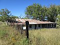
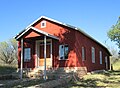
A few people still live in Lochiel to this day. In addition to a collection of old houses, Lochiel is the site of an adobe one-room schoolhouse, a teacherage, an old adobe church and cemetery, and an abandoned U.S. Customs station. [9] Lochiel is also the site where Fray Marcos de Niza first entered what is now Arizona. [4] A large memorial just to the west of town was erected in his honor in 1939 by the National Youth Administration. [10]

See also

Related Research Articles

<span class="mw-page-title-main">Santa Cruz County, Arizona</span> County in Arizona, United States

Santa Cruz is a county in southern Arizona, United States. As of the 2020 census, the population is 47,669. The county seat is Nogales. The county was established in 1899. It borders Pima County to the north and west, Cochise County to the east, and the Mexican state of Sonora to the south.

<span class="mw-page-title-main">Nogales, Arizona</span> City in Arizona, United States

Nogales is a city in Santa Cruz County, Arizona. The population was 20,837 at the 2010 census and estimated 20,103 in 2019. Nogales forms part of the larger Tucson–Nogales combined statistical area, with a total population of 1,027,683 as of the 2010 Census. The city is the county seat of Santa Cruz County.

<span class="mw-page-title-main">Patagonia, Arizona</span> Town in Arizona, United States

Patagonia is a town in Santa Cruz County, Arizona, United States. As of the 2010 census it had a population of 913. It developed in the mid-19th century as a trading and supply center for nearby mines and ranches. In the 21st century, it is a tourist destination, retirement community, and arts and crafts center.

<span class="mw-page-title-main">Fairbank, Arizona</span> Ghost town in Cochise County, Arizona

Fairbank is a ghost town in Cochise County, Arizona, next to the San Pedro River. First settled in 1881, Fairbank was the closest rail stop to nearby Tombstone, which made it an important location in the development of southeastern Arizona. The town was named for Chicago investor Nathaniel Kellogg Fairbank who partially financed the railroad, and was the founder of the Grand Central Mining Company, which had an interest in the silver mines in Tombstone. Today Fairbank is located within the San Pedro Riparian National Conservation Area.

<span class="mw-page-title-main">Santa Cruz River (Arizona)</span> River in Arizona, United States

The Santa Cruz River is a left tributary of the Gila River in Southern Arizona and northern Sonora, Mexico. It is approximately 184 miles (296 km) long.

<span class="mw-page-title-main">Sonoita Creek</span> Waterway in Santa Cruz County, Arizona

Sonoita Creek is a tributary stream of the Santa Cruz River in Santa Cruz County, Arizona. It originates near and takes its name from the abandoned Pima mission in the high valley near Sonoita. It flows steadily for the first 15 miles (24 km) of its westward course past Patagonia, its bird sanctuary and Patagonia Lake, but sinks beneath the sand seven to eight miles before joining the Santa Cruz River a few miles north of Nogales. This confluence provides water for Tumacácori and Tubac and collects in the marsh lands around San Xavier del Bac downstream, to the north. The Santa Rita Mountains lie to the north and the Canelo Hills, Red Mountain and the Patagonia Mountains lie to the south. Harshaw Creek is a southern tributary which joins the Sonoita near Patagonia. Harshaw Creek drains the area between the Patagonia Mountains to the west and the high San Rafael Valley grasslands to the east. The ghost town of Harshaw lies within its watershed.

<span class="mw-page-title-main">Kentucky Camp, Arizona</span> United States historic place

Kentucky Camp is a ghost town and former mining camp along the Arizona Trail in Pima County, Arizona, United States, near the community of Sonoita. The Kentucky Camp Historic District is listed on the National Register of Historic Places and has been since 1995. As it is located within Coronado National Forest, the United States Forest Service is responsible for the upkeep of the remaining buildings within the Kentucky Camp Historic District.

<span class="mw-page-title-main">Mission San Cayetano de Calabazas</span> Historic mission ruins in Arizona

Mission San Cayetano de Calabazas, also known as Calabasas, is a Spanish Mission in the Sonoran Desert, located near present-day Tumacacori, Arizona, United States. The Mission was named for the Italian Saint Cajetan.

<span class="mw-page-title-main">San Rafael Valley</span> Landform in Santa Cruz County, Arizona

The San Rafael Valley is a high intermontane grass valley in eastern Santa Cruz County, Arizona. The valley is bounded to the west by the Patagonia Mountains, to the north and northeast by the Canelo Hills and to the east by the Huachuca Mountains in Cochise County. The valley forms the headwaters of the Santa Cruz River which flows south into Sonora, Mexico just east of the historic Lochiel townsite.

<span class="mw-page-title-main">Harshaw, Arizona</span> Ghost town in Arizona, United States

Harshaw is a ghost town in Santa Cruz County in the southeastern part of the U.S. state of Arizona. The town was settled in the 1870s, in what was then Arizona Territory. Founded as a mining community, Harshaw is named after the cattleman-turned-prospector David Tecumseh Harshaw, who first successfully located silver in the area. At the town's peak near the end of the 19th century, Harshaw's mines were among Arizona's highest producers of ore, with the largest mine, the Hermosa, yielding approximately $365,455 in bullion over a four-month period in 1880.

<span class="mw-page-title-main">The Little Outfit Schoolhouse</span> United States historic place

The Little Outfit Schoolhouse is a ranch school that was built in 1940 in southeastern Arizona. It is located on the Little Outfit Ranch in San Rafael Valley, about ten miles east-southeast of Patagonia, in Santa Cruz County, which borders Mexico on the south and is about 80 miles from Arizona's eastern border with New Mexico.

<span class="mw-page-title-main">Patagonia Mountains</span> Landform in Santa Cruz County, Arizona, US and Sonora, Mexico

The Patagonia Mountains are a 15-mile-long (24 km) mountain range within the Coronado National Forest, and in Santa Cruz County, Arizona, United States.

<span class="mw-page-title-main">Pajarito Mountains (Arizona)</span> Mountain range in the US state of Arizona and the Mexican state of Sonora

The Pajarito Mountains is a small mountain range of western Santa Cruz County, Arizona, United States, that extend south into Sonora, Mexico. The range is adjacent the Atascosa Mountains at its north, with both ranges in the center of a north-south sequence of ranges called the Tumacacori Highlands. The Highlands have the Tumacacori Mountains at the north, and south of the U.S.-Mexico border, the Sierra La Esmeralda range. The Tumacacori Highlands are part of a regional conservancy study of "travel corridors" for cats, called Cuatro Gatos, Four Cats, for mountain lions, ocelot, bobcat, and jaguar.

<span class="mw-page-title-main">San Rafael Ranch</span> United States historic place

The San Rafael Ranch, formerly known as the Greene Ranch, is a historic cattle ranch located in the San Rafael Valley about a mile and a half north of Lochiel, Arizona, near the international border with Sonora, Mexico.

<span class="mw-page-title-main">Hale Ranch</span> Cattle ranch in Santa Cruz County, Arizona

The Hale Ranch is a working cattle ranch headquartered in the ghost town of Harshaw, in the Patagonia Mountains of southeastern Arizona.

<span class="mw-page-title-main">Duquesne, Arizona</span> Ghost town in Santa Cruz County, Arizona

Duquesne is a ghost town in the Patagonia Mountains in eastern Santa Cruz County, Arizona, near the international border with Sonora, Mexico. The town, which is currently under private ownership and closed to the public although the roads are almost all public, was once the headquarters of the Duquesne Mining and Reduction Company and is the site of the Bonanza Mine. Washington Camp is approximately one mile northwest of Duquesne and was where the mine's reduction plant was located.

<span class="mw-page-title-main">Little Boquillas Ranch</span> Historic ranch in Cochise County, Arizona

The Little Boquillas Ranch is an historic ranch property located in western Cochise County, Arizona, near the Fairbank Historic Townsite in what is now part of the San Pedro Riparian National Conservation Area.

<span class="mw-page-title-main">Calabasas, Arizona</span> Ghost town in Santa Cruz County, Arizona, US

Calabasas is a former populated place or ghost town, within the Census-designated place of Rio Rico, a suburb of Nogales in Santa Cruz County, Arizona.

References

  1. "Feature Detail Report for: Lochiel". Geographic Names Information System . United States Geological Survey, United States Department of the Interior.
  2. 1 2 Nogales, Arizona, 30x60 Minute Topographic Quadrangle, USGS, 1994
  3. Massey, Peter; Welburn Wilson, Jeanne (2006). Backcountry Adventures Arizona: The Ultimate Guide to the Arizona Backcountry for Anyone With a Sport Utility Vehicle. Backcountry Adventures Series. Adler Publishing. p. 42. ISBN   978-1930193284.
  4. 1 2 3 4 5 6 James E. & Barbara H., Sherman (1969). Ghost Towns of Arizona. University of Oklahoma. ISBN   0806108436.
  5. 1 2 3 Barr, Betty (2006). Hidden Treasures of Santa Cruz County. BrockingJ Books. ISBN   0979026105.
  6. Fraser-Mackintosh, C. (1888). The Celtic Magazine: A Monthly Periodical Devoted to the Literature, History, Antiquities, Folk-lore, Traditions, and the Social and Material Interests of the Celt at Home and Abroad, Volume 13. A. & W. Mackenzie. pp. 466–7.
  7. Price, Jay M. (2004). Gateways to the Southwest: The Story of Arizona State Parks. University of Arizona Press. ISBN   0816522871.
  8. "Arizona State Parks: San Rafael Ranch". Archived from the original on December 27, 2014. Retrieved December 10, 2014.
  9. Varney, Philip (1980). "Nine: South of Sonoita". Arizona's Best Ghost Towns. Flagstaff: Northland Press. p. 100. ISBN   0873582179. LCCN   79-91724.
  10. "Archaeology Southwest: Descriptions of Important Historic Sites" (PDF). Archaeology Southwest. Retrieved February 16, 2015.